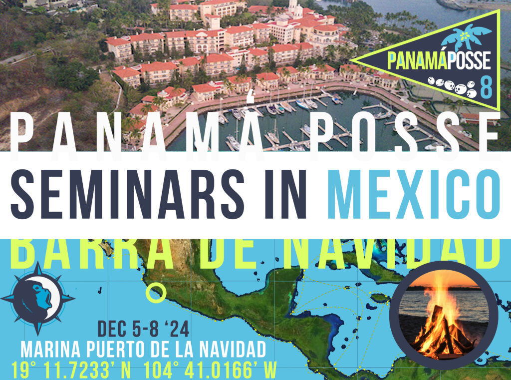
https://oceanposse.com/events/ocean-posse-kick-off-week/

OCEAN POSSE KICK OFF 🇲🇽 BARRA DE NAVIDAD, MEXICO December 3-7 2025

WHEN: December 3-7 2025

WHERE: Barra de Navidad, MX at the Marina Puerto de la Navidad

RSVP PLEASE AND CONTACT THE MARINA DIRECTLY TO RESERVE A SLIP

RSVP Some of these seminars are recorded and place them online for participants >>

Here are our tentative dates for our seminars in early December in Barra de Navidad, Mexico !


Wednesday December 3, 2025    

    1)  10:00 PANAMA POSSE INTRO AND OVERVIEW   and Fleet Tracking

   2)  13:00 ROUTE PLANNING & NAVIGATION    


Thursday December 4,  2025

   3)  10:00 DANGERS & SAFETY

  4)  13:00 COMMUNICATIONS, WEATHER,

   5)  17:00 PANAMA POSSE KICK OFF PARTY


Friday  December 5, 2025

   6)  13:00 SATELLITE CHARTS / OPEN CPN / GOOD NAUTICAL

  7)  17:00 PANAMA POSSE OVER THE TOP POT LUCK RED CUP DOCK PARTY
-> details here on how to win the chef award ->


Saturday December 6, 2026

   8)  10:00 AM  Swapmeet

   9 )   13:00 PROVISIONING, WHAT TO SEE AND DO, RECAP, Q&A  


SUNDAY December 7, 2025

  10) SAIL TO TENECATITA BAY FOR A SUNDAY OF BEACH AND FUN

  11)  BONFIRE ON THE BEACH ⚓ 19° 17.975' N 104° 50.1316' W


MARINA PUERTO AVENTURAS 🇲🇽 SPONSORS THE OCEAN POSSE

MARINA PUERTO AVENTURAS 🇲🇽 SPONSORS THE OCEAN POSSE
20°29.7333′ N 087°13.4666′ W

Marina Puerto Aventuras

Thank you for your phone call. It’s a pleasure. We are pleased to offer a 15% discount to all Ocean Posse members.

Captain gsegrove70@hotmail.com

HARBORMASTER Cap. Gerardo Segrove

Whatsapp +52 984 8010117
Whatsapp +52 984 1163813

VHF 79 A & 16
TEL: +52  984 873 5108
Cell: +52 984 116 3813

 Puerto Aventuras is the only marina between Cancun and Belize that offers boaters all the services of a high-seas nautical destination for boats up to 150 feet, including catamarans and sailboats.

From here, discover the infinity of destinations that you can visit while sailing through the Riviera Maya and the paradisiacal coasts and islands of the Mexican Caribbean. A few nautical miles you can find places like the Mujeres Islands, Cozumel, Contoy and Holbox; as well as Chinchorro, the coasts of Belize and many other places in the Caribbean.

AMENITIES

  • 30/50/100 AMP Shore-power
  • Water
  • Diesel Fuel
  • 24 Hour Security
  • Restaurants
  • Shops
  • Laundry
  • Farmers Market
  • Beaches
  • Beach & Pool Club  ( subject to access / consumption fees )
  • Supermarket  Chedraui 2.7 km

Marina Puerto Aventuras approach

SAFE APPROACH TO MARINA PUERTO AVENTURAS MAX DEPTH 2 M


MARKERS
safe approach

LOCATION


MEXICO 🇲🇽 PACIFIC & CARIBBEAN – CRUISING MEXICO AND CENTRAL AMERICA WITH THE OCEAN POSSE


🇲🇽 MEXICO - PACIFIC

THE BAJA RUN

1. Ensenada (Cruiseport Village Marina)

Located just 65 miles south of San Diego, Ensenada is the first major port of entry in Mexico. The Cruiseport Village Marina offers a convenient spot for clearing customs and immigration. Ensenada itself is known for its vibrant nightlife, including iconic places like Hussong’s Cantina. Aside from practical marina services, the town has a lively blend of culture, history, and food. Wine enthusiasts often venture into the nearby Valle de Guadalupe, a premier Mexican wine region. Ensenada is also a popular stop to stock up on provisions before continuing down the Baja coast.

2. Punta Santo Tomas

This anchorage, approximately 50 miles south of Ensenada, is a quieter spot, ideal for those looking to get away from the city. While the bay offers protection from northwesterly winds, you must navigate around outlying rocks and kelp beds. There isn’t much development ashore, but it’s a peaceful and scenic location for an overnight stop. It’s a great place for fishing and exploring the surrounding rugged coastline.

3. Bahía Colonet

Around 40 miles south of Punta Santo Tomas, Bahía Colonet offers another quiet anchorage with good protection from northwesterly winds. The bay is surrounded by steep cliffs and sandy beaches, making it a scenic spot to relax. There is little to no development here, making it a perfect spot for those seeking a more remote and natural environment. The waters are often calm, and the anchorage provides excellent holding ground for vessels.


4. Isla San Martín

Located about 30 nautical miles south of Bahía Colonet, Isla San Martín offers two anchorages: one on the north and another on the south, depending on the swell. The island itself is a volcanic formation, offering protection from the wind but not from strong south swells. The waters around Isla San Martín are rich in marine life, making it a favorite spot for divers and fishermen. Ashore, you’ll find a barren landscape with some low-lying vegetation, but the real attraction here is the sense of isolation and tranquility. The island’s rocky shoreline requires careful navigation when anchoring.

5. Bahía San Quintín

About 110 nautical miles south of Ensenada, Bahía San Quintín is a large bay offering well-protected anchorage suitable for a range of vessel sizes. The bay is shallow on the west side, while the deeper parts can accommodate deeper-draft vessels. You need to be cautious of shoaling near the entrance, but once inside, the bay is calm and offers good holding. The surrounding area is known for its fishing industry, and there are opportunities to go ashore to explore the nearby villages. This bay is a popular stopover for cruisers making their way down the Baja coast or returning north.

6. Isla San Geronimo

Approximately 39 nautical miles south of Bahía San Quintín, Isla San Geronimo offers a fair-weather anchorage. It’s a small, isolated island, known for its bird populations and scenic cliffs. The island provides minimal protection, so it’s not ideal in adverse weather. However, when the weather is calm, this spot is a peaceful, scenic stopover with crystal-clear waters, great for snorkeling and exploring the surrounding rocks. Mariners should be cautious of two submerged rocks located south of the island.

7. Fondadero San Carlos

Located 68 nautical miles south of Bahía San Quintín, Fondadero San Carlos is a popular anchorage, particularly for vessels heading north. The anchorage is somewhat exposed but offers decent protection from the wind. Mariners should be aware of kelp beds and some shoaling on the northern bight. The area is remote, with no major facilities ashore, but it provides a peaceful stopover during long transits. Wildlife is abundant in the region, and it’s a good spot for a quiet night on anchor before continuing further south.

8. Isla Cedros (North Anchorage)

Isla Cedros, about 80 nautical miles south of Fondadero San Carlos, is a popular stop for cruisers, especially those waiting for favorable weather to continue their journey. The northern anchorage of Isla Cedros, also known as the “Cedros Island Yacht Club Anchorage,” is a roadstead that offers limited protection, as it’s exposed to both northern and southern winds. Despite this, it’s a common stop due to its proximity to shipping lanes and the wildlife in the area, including sea lions and a variety of bird species. Cedros Island has a small fishing village that provides limited services, but it’s a charming spot to explore the rugged coastline and local culture. The anchorage can be quite rolly, particularly in the afternoon when winds pick up, so many cruisers prefer to leave early in the morning.

9. Bahía Tortugas (Turtle Bay)

Bahía Tortugas, or Turtle Bay, is one of the most well-known stops along the Baja Run. Located about 50 nautical miles south of Isla Cedros, this large bay offers excellent protection from winds and swells, making it a comfortable and reliable anchorage. The surrounding village is small and dusty, but it offers some basic services, including fuel (although at a premium). Fuel can be procured from the dock or delivered by panga, but cruisers are advised to check the quality and pricing of fuel carefully. Bahía Tortugas is often considered the halfway point to Cabo San Lucas, making it a significant stop for provisioning and resting before continuing south.

10. Bahía Asunción

Roughly 50 nautical miles south of Bahía Tortugas lies Bahía Asunción. This fair-weather anchorage offers good holding ground and protection from the northwesterly winds. The surrounding area is sparsely populated, with a small fishing village offering limited facilities. The area is known for its rich marine life, making it an excellent spot for fishing and diving. While it’s a quiet and scenic stop, weather conditions can make it uncomfortable, so it’s best to visit during calmer periods. The landscape is rugged, with cliffs and sandy beaches providing an idyllic setting for those seeking a more isolated anchorage.

11. Bahía San Hipólito

Located approximately 40 nautical miles south of Bahía Asunción, Bahía San Hipólito is another excellent spot for cruisers making their way down the Baja coast. The bay offers decent protection from northwesterly winds and is home to a small fishing community. While there aren’t many facilities available here, the bay is known for its pristine waters and abundant marine life. Fishing and diving are popular activities, with lobster being a significant catch in the area. The shoreline is rugged, with sandy beaches and rocky cliffs, making it a scenic and peaceful stopover for cruisers.

12. Punta Abreojos

About 45 miles south of Bahía San Hipólito, Punta Abreojos offers a well-protected anchorage, though it can be exposed to strong winds, particularly in the afternoons. The area is known for its rich biodiversity, especially its grey whale migration, which can be observed between December and April. The surrounding village is small but friendly, with limited services and provisions. Punta Abreojos is a remote location, with beautiful sandy beaches and opportunities for wildlife watching, particularly birdlife. This spot is ideal for cruisers looking to experience Baja’s natural beauty and tranquility.

13. Bahía Ballenas

Situated just north of Bahía Magdalena, Bahía Ballenas offers a well-sheltered anchorage with protection from the prevailing winds. The bay is surrounded by beautiful beaches and dunes, making it a great spot for exploring ashore. The waters are generally calm, and the holding ground is good, making this a reliable stop for those traveling down the coast. There are no significant facilities here, so it’s a place for peaceful anchoring and relaxation rather than provisioning.

14. Bahía Magdalena (Mag Bay)

Bahía Magdalena, often referred to as “Mag Bay,” is one of the most famous anchorages along the Baja coast. Located about 160 miles south of Punta Abreojos, it’s a vast, protected bay with calm waters and abundant wildlife. The bay is known for its role in the annual grey whale migration, making it a popular destination for wildlife enthusiasts between December and March. The surrounding area is mostly undeveloped, but the nearby town of Puerto San Carlos offers some provisions and fuel. Mag Bay is also known for its excellent fishing, with marlin, tuna, and other game fish frequently caught in the area. Cruisers often spend several days here to enjoy the natural beauty and wildlife.

15. Cabo San Lucas

At the southern tip of the Baja Peninsula lies Cabo San Lucas, a world-renowned destination for sailors and tourists alike. Cabo offers modern marina facilities, excellent restaurants, and vibrant nightlife, making it a major hub for cruisers entering or leaving the Sea of Cortez. The waters around Cabo are teeming with marine life, and it’s a great spot for snorkeling, diving, and sportfishing. While the town itself can be bustling and tourist-oriented, it’s an essential stop for provisioning, repairs, and relaxation after a long journey down the Baja coast.


INTO THE SEA OF CORTEZ

1. Cabo San Lucas

Cabo San Lucas is the jumping-off point for entering the Sea of Cortez. The modern marinas and excellent services in Cabo make it an ideal place to restock and prepare for the journey. It’s a lively spot with vibrant nightlife, fantastic restaurants, and good repair facilities.

2. Los Frailes

Located about 45 nautical miles northeast of Cabo, Los Frailes is a calm and beautiful anchorage. It offers excellent protection from the north winds and is a fantastic spot for snorkeling and diving at the nearby Cabo Pulmo National Park, one of the oldest coral reefs in the Pacific. The bay has good holding, and its clear waters make it popular with cruisers looking to unwind and explore.

3. Bahía de los Muertos (Bahía de los Sueños)

Around 50 nautical miles from Los Frailes, Bahía de los Muertos is a well-protected bay with a sandy bottom, making for excellent holding. It’s a great spot to rest after a day of sailing, with crystal-clear waters and some beachside restaurants nearby. This bay is often referred to as Bahía de los Sueños (Bay of Dreams), and it’s a favorite stop for cruisers due to its calm conditions.

4. La Paz

La Paz, the capital of Baja California Sur, is a major stop for cruisers and a gateway to the Sea of Cortez. About 50 nautical miles from Bahía de los Muertos, La Paz offers several marinas, boatyards, and provisioning options. The city is known for its vibrant culture, great restaurants, and long malecon (waterfront promenade). There are numerous anchorages around La Paz, such as Bahía Falsa and El Mogote, but the currents can be tricky, so mariners need to be careful.

5. Isla Espíritu Santo

Approximately 20 nautical miles north of La Paz, Isla Espíritu Santo is a UNESCO Biosphere Reserve and a crown jewel of the Sea of Cortez. The island offers numerous anchorages, including Bahía San Gabriel, Caleta Partida, and Ensenada Grande, all known for their crystal-clear waters, beautiful beaches, and fantastic snorkeling. These anchorages are well-protected and offer calm, serene spots for cruisers. Sea lions, dolphins, and a variety of bird species are common in the area.

6. Isla San Francisco

About 25 nautical miles further north from Isla Espíritu Santo, Isla San Francisco is a stunning anchorage known for its crescent-shaped bay and turquoise waters. The island is a popular stop for hiking, with trails that lead to beautiful vistas of the surrounding sea. It’s also an excellent place for fishing, snorkeling, and kayaking. The bay provides good protection and holding, making it a favorite among cruisers.

7. Bahía Agua Verde

Heading another 50 nautical miles north, Bahía Agua Verde is one of the most picturesque anchorages in the Sea of Cortez. It’s a well-protected bay surrounded by rugged mountains and clear, calm waters. The small fishing village ashore offers limited provisions, but the anchorage itself is ideal for swimming, snorkeling, and exploring the surrounding areas. The holding is good, and it’s a great place for cruisers to spend a few days relaxing.

8. Puerto Escondido

About 30 nautical miles further north, Puerto Escondido is a fantastic hurricane hole and one of the safest anchorages in the Sea of Cortez. The inner harbor is almost completely enclosed, providing excellent protection in all weather conditions. The marina offers services such as fuel, water, and provisions. It’s a popular stop for cruisers heading to Loreto.

9. Loreto

Just 15 nautical miles north of Puerto Escondido, Loreto is one of the most historically and culturally significant towns on the Baja Peninsula. The town has a rich history, with Spanish missions and colonial architecture. Loreto is a convenient stop for provisioning and exploring nearby anchorages, such as Isla Coronado, a stunning island with white sandy beaches and clear waters perfect for snorkeling and diving.

SEA OF CORTEZ TO PUERTO VALLARTA


1. Isla Coronado (near Loreto)

Before leaving Loreto, Isla Coronado offers a final tranquil anchorage. Located just a short sail north from Loreto, this island is known for its white sand beaches and turquoise waters, making it ideal for snorkeling and relaxing. It’s a good stop for preparing your vessel before crossing the Sea of Cortez.

2. San Carlos (Mainland)

After a roughly 85-mile crossing from Loreto, San Carlos, located on the mainland, is a well-protected harbor offering a comfortable marina with good services, including provisions, fuel, and repairs. San Carlos is known for its scenic cliffs and sandy beaches. The area is also popular for hiking and exploring the nearby Tetakawi Mountain. The town provides all essential cruiser amenities and is an ideal stop after a Sea of Cortez crossing.

3. Bahía Kino

About 60 miles southeast of San Carlos, Bahía Kino is a small coastal village with a decent anchorage and good holding ground. While the facilities here are limited, the area offers a peaceful atmosphere and beautiful sunsets over the Sea of Cortez. It’s a quiet stop for those seeking a bit of solitude before heading south.

4. Topolobampo

Further south, around 150 miles from San Carlos, Topolobampo is a well-protected port known for its proximity to the Copper Canyon, one of the most famous natural attractions in Mexico. While the town itself is small, it offers marina services and provisions. This is a good anchorage for those who want to venture inland to see the Copper Canyon via train, one of Mexico’s most scenic inland trips.

5. Mazatlán

Continuing south, about 180 miles from Topolobampo, Mazatlán is one of the larger cities on the mainland coast and a major cruising hub. The town features multiple marinas, including Marina El Cid and Marina Mazatlán, both of which offer full services. Mazatlán’s historic old town, beaches, and vibrant nightlife make it a favorite stop for cruisers. The city is also an excellent spot for provisioning, refueling, and making repairs before continuing south.

6. Isla Isabel

About 90 nautical miles south of Mazatlán, Isla Isabel is often called the “Galápagos of Mexico” due to its rich wildlife, including seabird colonies and iguanas. The island is a national park, and the surrounding waters are excellent for snorkeling and diving. The anchorage is exposed, so cruisers should monitor weather conditions carefully, but in calm seas, this stop is a highlight for nature lovers. There’s minimal protection from swells, but the wildlife and beauty make it worth the visit.

7. San Blas

Roughly 45 miles south of Isla Isabel, San Blas is a small town with a colorful history dating back to the Spanish colonial period. The town offers basic services, and the nearby La Tovara National Park is famous for its mangrove swamps and crocodile sightings. San Blas is known for its mosquitos, so cruisers should prepare accordingly. The anchorage is relatively calm, with decent protection from northwesterly winds.

8. Chacala

Another 35 miles south of San Blas, Chacala is a small, picturesque bay with a peaceful anchorage and a sandy beach lined with palm trees. The town is tiny, but it’s a great spot for cruisers to relax and enjoy the quiet atmosphere. The anchorage is relatively shallow, making it easy to find good holding ground close to shore.

9. La Cruz de Huanacaxtle (Banderas Bay)

Situated within Banderas Bay, just 10 miles from Puerto Vallarta, La Cruz de Huanacaxtle is a favorite anchorage and marina for cruisers. The Marina Riviera Nayarit offers full services, and the town of La Cruz has a lively cruiser community, with restaurants, music, and a Sunday market. Banderas Bay is one of the largest bays in Mexico, providing sheltered waters and a variety of activities, from whale watching to deep-sea fishing.

10. Puerto Vallarta

Finally, Puerto Vallarta, located at the southern end of Banderas Bay, is a major destination for both tourists and cruisers. The city offers several marinas, including Marina Vallarta and the newer Paradise Village Marina in Nuevo Vallarta. Puerto Vallarta is known for its colonial charm, vibrant arts scene, and beautiful beaches. The city provides excellent services, provisioning, and entertainment, making it a popular destination for long-term stays or a base for further exploration along Mexico’s Pacific coast.

PUERTO VALLARTA TO BARRA DE NAVIDAD


1. Los Arcos, Banderas Bay

Just 6 miles south of Puerto Vallarta, Los Arcos is a popular anchorage within Banderas Bay. It’s known for its dramatic rock formations and crystal-clear waters, perfect for snorkeling and diving. The anchorage is exposed, so it’s best for a day stop to explore the marine park.

2. Yelapa

Approximately 15 nautical miles south of Puerto Vallarta, Yelapa is a charming village tucked into a lush jungle cove. There are no roads to Yelapa, and it’s only accessible by boat, giving it an isolated, relaxed atmosphere. The anchorage can be a bit rolly, but it’s an excellent place to enjoy waterfalls, hiking, and local seafood.

3. Chimo

Located further south at the southern tip of Banderas Bay, Chimo is a small, quiet fishing village with a calm anchorage. It’s a great place to experience the traditional lifestyle of the region, and the rugged beauty of the surrounding landscape is a highlight.

4. Cabo Corrientes

Roughly 25 miles south of Puerto Vallarta, Cabo Corrientes marks the southernmost point of Banderas Bay and is known for its strong winds and currents. There are no protected anchorages at the cape, but cruisers can make a quick stop in one of the nearby bays before rounding the cape.

5. Ipala Bay

Located just south of Cabo Corrientes, Ipala Bay is a well-protected anchorage that offers calm waters and good holding. The small fishing village here provides a peaceful atmosphere, and it’s an ideal stop for rest after rounding the cape. It’s a good place to relax and enjoy the quiet surroundings.

6. Bahía Chamela

About 60 miles south of Ipala, Bahía Chamela is a large, protected bay with excellent holding and several smaller islands to explore. The anchorage near Pérula village is a favorite for cruisers, offering peaceful waters, scenic beaches, and opportunities for beachcombing, snorkeling, and paddleboarding.

7. Careyes

A little further south, Careyes is a luxurious resort area with strikingly clear waters and dramatic cliffs. The small anchorage offers decent protection, and the setting is picturesque, with colorful houses and upscale resorts ashore. It’s an excellent stop for those seeking a touch of elegance in their cruising.

8. Bahía Paraíso

Situated south of Careyes and north of Bahía Chamela, Bahía Paraíso is a secluded and stunning anchorage. It’s known for its clear waters, lush surroundings, and relative isolation, making it a peaceful and tranquil stop for cruisers seeking a bit of privacy. There are few facilities ashore, but the natural beauty more than compensates. The anchorage offers decent protection in calmer conditions, though it’s best to monitor the weather carefully. This bay is a hidden gem, perfect for those wanting to experience the untouched beauty of the Pacific coast.

9. Tenacatita Bay

Around 20 miles from Barra de Navidad, Tenacatita Bay is one of the most beloved anchorages along this coast. The bay offers excellent protection, good holding, and a long sandy beach for swimming and exploring. The famous jungle river trip up the estuary is a must-do experience for cruisers, with the mangrove-lined waterway filled with wildlife.

10. Barra de Navidad

The final stop, Barra de Navidad, is a peaceful lagoon anchorage surrounded by the charming town of Barra. The lagoon offers excellent protection and has become a cruiser’s haven with plenty of services available. The town itself is small but has a good selection of restaurants and shops, making it an ideal place to provision, relax, and enjoy the local culture.

🇲🇽 MEXICO - CARIBBEAN

WEATHER

TIDAL RANGE PACIFIC

  • North Ensenada 8.5 Feet
  • North Inside the Sea of Cortez tidal range 21 feet
  • Central Mexico Puerto Vallarta 6.1 feet
  • Central Mexico Acapulco 4 feet
  • South Mexico Chiapas 6 feet

TIDAL RANGE CARIBBEAN

  • Isla Mujeres Mexico 1.21ft. (0.37m)
  • Cancun 0.8 feet
  • Veracruz Mexico 3.18ft. (0.97m).


MEXICO PILOT CHARTS PACIFIC

Mexican Pilot Charts delineate measuring pints wind and flows, air and ocean temperatures, wave heights,  rain, barometric weight, and climate conditions at various seasons. The data used to assemble these midpoints was acquired from oceanographic and meteorologic perceptions over hundreds of years during the late eighteenth and nineteenth hundreds of years.

The diagrams are planned to help the prudent mariner choose routes  with respect to the normal climate and sea conditions. For an explanation of historic Mexican’s Climatology and how to read Wind-roses follow this link.

MEXICO PACIFIC HISTORIC HURRICANE TRACKS

MEXICO PILOT CHARTS CARIBBEAN

Pilot Charts of Mexico Caribbean depict averages in prevailing winds and currents, air and sea temperatures, wave heights, ice limits, visibility, barometric pressure, and weather conditions at different times of the year. The information used to compile these averages was obtained from oceanographic and meteorologic observations over many decades during the late 18th and 19th centuries. Charts aid the navigator in selecting the fastest and safest routes with regards to the expected weather and ocean conditions. For an explanation of historic Mexican Caribbean Climatology and how to read Wind-roses follow this link.

MEXICO CARIBBEAN HISTORIC HURRICANE TRACKS

PORTS OF ENTRY


Ensenada 31° 51.3′ N 116° 37.2′ W
Cabo San Lucas 22° 53.2′ N 109° 54.6′ W
Puerto Vallarta 20° 39.1′ N 105° 14.0′ W
Manzanillo 19° 03.0′ N 104° 19.8′ W
Acapulco 16° 50.7′ N 99° 54.3′ W
Mazatlán 23° 12.3′ N 106° 25.3′ W
Guaymas 27° 55.5′ N 110° 54.3′ W
La Paz 24° 09.5′ N 110° 18.4′ W
Huatulco 15° 45.2′ N 96° 07.6′ W
Cancún 21° 09.2′ N 86° 50.4′ W
Progreso 21° 17.9′ N 89° 39.2′ W
Veracruz 19° 11.4′ N 96° 08.6′ W
Puerto Morelos 20° 51.2′ N 86° 52.4′ W
Isla Mujeres 21° 14.1′ N 86° 44.7′ W
Cozumel 20° 30.8′ N 86° 57.6′ W
Tampico 22° 12.0′ N 97° 51.9′ W
Altamira 22° 23.5′ N 97° 54.6′ W
Puerto Chiapas (Madero) 14° 41.0′ N 92° 24.0′ W
Lázaro Cárdenas 17° 57.1′ N 102° 12.6′ W
Topolobampo 25° 36.8′ N 109° 03.0′ W

Empty tab. Edit page to add content here.
DOCUMENTATION MEXICO
OPERATOR LICENSE MEXICO
DOWNLOAD THE MEXICO BOATING GUIDE » 2024 Mexico Boating Guide and Entry Procedures
LA PAZ CLUB CRUCEROS GUIDE la paz cuisers guide
Passport Valid for at least 6 months; requires one blank page
Boat Documentation Coast Guard Doc (Original)
Proof of Insurance Liability from a Mexican provider required
Crewlist Required at checkin/out
Zarpe Required at checkin/out
FISHING LICENSE Required for each person BUY ONLINE @ sportfishingbcs.gob.mx
OFFICIAL PROCEDURES
Official Country Visa None if stay is less than 180 days
$25 to replace if you loose the little card in your passport
Immigration Visa Good for 180 days; must leave country to renew
Required Permits TIP (Temporary Import Permit) - good for 10 years; fishing license required for each person aboard
Upon Arrival Visit: Immigration; Customs; Port Authority
Upon Departure Visit: Immigration; Customs; Port Captain
Entry & Exit Fees: Free to $50
Notes: Expect to be boarded by Navy upon entering and/or leaving the country
Immigration IMMIGRATION REQUIREMENTS WHICH MAY BE PROCESSED BY YOU
PRIOR TO ARRIVAL IN MEXICO BY PRIVATE BOAT
STEP ONE
Visit the following Internet portal to apply for entry to Mexico and pay the required fees: https://www.banjercito.com.mx/registroEmbarques/
Follow the instructions and save the electronic receipt. You will need it when you e-mail the passenger list to INM in the next step. Also print out a copy to keep with you on the boat.
The following information must be provided:
a. Passport number of the person responsible for the vessel
b. Vessel Documentation (State or Federal Documentation).
c. A $332 Mexican Pesos fee per each visiting foreigner as required
by the Federal Fee Act (Ley Federal de Derechos), Article 8, Section
I. The fee must be paid using a credit card. The cardholder should
be the same person responsible for the boat.STEP TWO
Download and complete the spreadsheet with the information of the vessel and passengers from:
http://www.inm.gob.mx/index.php/page/instrucciones_para_pasajeros/en.html
Here you will find the following:
A Sample Form (spreadsheet) for submission of a list of maritime passengers and crew members — delete the sample information and insert your passenger list. Save it to your computer following the instructions on the web page including how to name the file
correctly.
A guide for filling the Form for the submission of a list of maritime
passengers and crew members
An e-mail Directory/List of INM Ports addresses for submission of
lists of maritime passengers and crew members.
OTHER
Required Vaccinations None
Pets Vaccination Certificate
Currency: Peso

PORTS OF ENTRY

Caribbean
Cozumel, Isla Mujeres, Progreso, Puerto Aventuras, Puerto Juarez, Puerto Morelos

Pacific
Acapulco, Cabo San Lucas, Ensenada, Huatulco, La Paz, Mazatlan, Puerto Chiapas, Puerto Penasco , Puerto Vallarta, Salina Cruz, San Blas, Santa Rosalia, Zihuatenejo

Crime Index Safety Index Corruption Index Corruption Score GDP Pop (M) Life Ex. Cost of Living Groc. Rest. $ Loc.Purch.P.
50.32 49.68 123 30% 8,699 124 76.7 29.39 28.88 26.78 50.43

US EMBASSY
TEL (01-55) 5080-2000
Paseo de la Reforma 305
Colonia Cuauhtenoc
06500 Mexico, DF

Read more


Las Grutas Cacahuamilpa 🇲🇽 MEXICO

Las Grutas Cacahuamilpa 🇲🇽 Guerrero, MEXICO

Las Grutas Cacahuamilpa  🇲🇽  Guerrero, MEXICO
16°51.0616' N   099°48.495' W

PATHFINDER


The Grutas de Cacahuamilpa National Park in Guerrero, Mexico, is best known for the Grutas de Cacahuamilpa Caverns, which are one of the largest cave systems in the world. It is also home to the Grutas of Carlos Pacheco, a smaller system, as well as two subterranean rivers which have carved out tunnels in the rock. The park has outdoor pursuit attractions such as rappelling, and rock climbing in Limontitla Canyon as well as the two underground rivers to explore. It also has a small botanical garden, a pool and places to camp. It's near Taxco.


The site is located in the Sierra Madre del Sur mountains in the northeast part of Guerrero state. This section of the Sierra Madre del Sur is made of rock, mostly limestone, which formed under oceans millions of years ago. The caverns extend through the municipalities of Pilcaya, Tetipac and Taxco of Guerrero state over 2,700 hectares of land located southwest of Mexico City, near the silversmithing town of Taxco.


Cacahuamilpa is one of the largest cave systems in the world. A "live" cave system as groundwater still filters down into it, and that the formations there are still growing. Inside the cavern system are ninety large "salons" separated by large natural rock walls and connected to one another via a central gallery. Only about twenty of these are fully explored and open to the public. Most of these salons are located under the Cerro de la Corona, a limestone mountain ridge.

These salons average about forty meters wide, and vary in height from twenty to 81 meters. Most have names which reflect the major formations found in them such as the Goat Salon, the Throne Salon and the Cathedral Salon. All the openings numerous rock formations growing from both the ceiling and the floor. One of the drier salons has been dubbed the “Auditorium”. It has a large flat floor and has been outfitted with seats.

LOCATION

Visiting Las Grutas de Cacahuamilpa, one of the largest cave systems in the world located in the state of Guerrero, Mexico, can be a thrilling and educational experience. Here are some tips to help you plan your visit:

Planning Your Visit

  1. Best Time to Visit:
    • The caves are open year-round, but the best time to visit is during the dry season (November to April) when the weather is more pleasant and the roads are in better condition.
  2. Getting There:
    • By Car: Las Grutas de Cacahuamilpa is about 2 hours from Mexico City. You can take the Autopista del Sol (Highway 95) towards Cuernavaca and then follow the signs to the caves.
    • By Bus: Buses run from Mexico City’s southern bus terminal (Terminal de Autobuses del Sur) to Taxco or directly to the caves. From Taxco, you can take a local bus or taxi to the caves.
  3. Entrance Fees:
    • There is an entrance fee to visit the caves. The fee typically includes a guided tour. Check the official website or local tourism offices for the most up-to-date prices.

What to Bring

  • Comfortable Shoes: The tour involves a lot of walking on uneven terrain.
  • Light Jacket: The temperature inside the caves is cooler than outside.
  • Water: Stay hydrated, but note that food and drinks are usually not allowed inside the caves.
  • Camera: Photography is allowed, but flash photography may be restricted to preserve the cave's natural environment.

During Your Visit

  1. Guided Tour:
    • Most visits are conducted as guided tours, which last about 2 hours. The guides are knowledgeable and can provide interesting information about the history and geology of the caves.
  2. Highlights to See:
    • Stalactites and Stalagmites: These impressive formations are a major draw.
    • The Salon del Luchador: A chamber named for its rock formations that resemble a wrestler.
    • The Cathedral: A vast chamber often used for concerts due to its excellent acoustics.
  3. Safety Tips:
    • Stay with your group during the tour.
    • Watch your step as the ground can be slippery.
    • Follow the guide's instructions at all times.

Nearby Attractions

  • Taxco: The nearby town of Taxco is famous for its silver jewelry and colonial architecture. It’s worth spending a day exploring this charming town.
  • Parque Nacional Grutas de Cacahuamilpa: The surrounding national park offers hiking trails and picnic areas for a day out in nature.

By planning ahead and knowing what to expect, you can make the most of your visit to Las Grutas de Cacahuamilpa and enjoy this natural wonder to its fullest


Sierra de San Francisco Murals 🇲🇽 Mexico

Sierra de San Francisco Murals 🇲🇽 Mexico

Rock Paintings of the Sierra de San Francisco 🇲🇽 BAJA CALIFORNIA Mexico

From c. 100 B.C. to A.D. 1300, the Sierra de San Francisco (in the El Vizcaino reserve, in Baja California) was home to a people who have now disappeared but who left one of the most outstanding collections of rock paintings in the world. They are remarkably well-preserved because of the dry climate and the inaccessibility of the site.

The central part of Baja California peninsula is a region of Mexico that concentrates one of the most extraordinary repertoires of rock art in the country, the Rock Paintings of the Sierra de San Francisco. The region is insular-like and kept the native peoples relatively isolated from continental influences, allowing the development of local cultural complex. One of the most significant features of the peninsular prehistory is the mass production of rock art since ancient times and the development of rock art tradition of the Great Murals.

Rock Paintings of the Sierra de San Francisco baja

The Sierra de San Francisco is the mountain range which concentrates the most spectacular and best preserved Great Mural sites, scale wise one of the largest prehistoric rock art sites in the world. Hundreds of rock shelters, and sometimes huge panels with hundreds and even thousands of brightly painted figures, are found in a good state of conservation. The style is essentially realistic and is dominated by depictions of human figures and marine and terrestrial fauna, designed in red, black, white and yellow, which illustrate the relationship between humans and their environment, and reveal a highly sophisticated culture. The paintings are found on both the walls and roofs of rock shelters in the sides of ravines that are difficult of access. Those in the San Francisco area are divided into four main groups – Guadalupe, Santa Teresa, San Gregorio and Cerritos. The most important sites are Cueva del Batequì, Cueva de la Navidad, Cerro de Santa Marta, Cueva de la Soledad, Cueva de las Flechas and Grutas del Brinco.


The landscape of the area is another significant attribute, understood as the extensive physical space in which, through rock art, the thoughts of their early dwellers, hunter-gatherers people who living here from the terminal Pleistocene (10,000 BP) until the arrival of Jesuit missionaries in the late seventeenth century, are expressed.

North of San Ignacio lies a mountain wilderness, the deeply eroded remains of layer upon layer of volcanic outpourings. This rugged mass rises from the surrounding desert to heights of more than 5,000 feet and covers an area 35 miles from north to south and half of that from east to west. From its uplands, there are views west to Scammon’s Lagoon and the Vizcaíno Desert, northwest to the even taller Sierra de San Borja, and east to the abrupt eminences of Las Tres Vírgenes, taller and more recent volcanos that tower in front of the Gulf. The sierra embraces a world that would never be suspected from the low, barren lands outside. Groves of palms and pools of water are set between walls of vertical grandeur water-carved from rich-colored rock. A few ranches, built by rustic and hospitable people, nestle near the few water sources. Here also are the grandest reminders of the Painters, corridors decorated by their hands and haunted by their spirits.

Rock Paintings

Showing human figures and many animal species and illustrating the relationship between humans and their environment, the paintings reveal a highly sophisticated culture. Their composition and size, as well as the precision of the outlines and the variety of colors, but especially the number of sites, make this an impressive testimony to a unique artistic tradition.


Cultural traditions, with roots back to the XVIII century, persist and the Sierra has a strong social value in the role that culture plays in the preservation of the traditional links between mountain communities and the South Californians and Mexicans in general.

Integrity

The Rock Paintings of the Sierra de San Francisco encompass an area of 183, 956 ha, where more than 400 sites have been recorded, the most important of them within the reserve, near San Francisco and Mulege, over 250 in all. The inscribed property contains an exceptional repertoire of rock art that convey its Outstanding Universal Value. The sites have remained virtually intact and still have a good state of conservation. The integrity of rock painting sites and their surroundings has been maintained largely due to the situation of isolation and the low population density that prevails in the region.

Protection and management requirements

The Rock Paintings of the Sierra de San Francisco are protected by the 1972 Federal Law on Historic, Archaeological and Artistic Monuments and Zones and fall under the protective and research jurisdiction of National Institute of Anthropology and History (INAH). In addition, the property is entirely within the Vizcaino Biosphere Reserve; which grants it with additional protection. The Management Plan has been in operation since 1994 and has proved a successful strategy in the administration of cultural resources of the property. This model emphasizes the importance of defining the meaning of this heritage site, so that all management strategies are consistently directed toward the preservation of the values that make it important. Another key feature is the total involvement of all those groups that have an interest in the area under discussion. The Management Plan focuses on issues such as mitigation of the impact of visitors on sites and control and monitor of access. Some measures included the installation of reversible infrastructure in seven of the most visited rock painting sites and the definition of authorized access paths, the areas open to the public or restricted, and four levels of access for tourists. This system allows visitors to experience a wide range of sites and at the same time protects the majority of those who are very well preserved. In this sense the most popular sites have remained open under this Management Plan. Threats remain that have to be addressed, including those derived from the proposals to construct roads within the protected area which would jeopardize the existing integrity between the landscape and the rock art sites.

Discovery

The medium and long term management expectations include obtaining additional legal protection through the presidential declaration of the area; allocating permanent custodian positions to improve monitoring, enhance the administrative and technological infrastructure of Sierra de San Francisco Information Unit located in San Ignacio town, capacity building for the custodians and guides and improvement of low-impact infrastructure for services.
https://www.bradshawfoundation.com/baja/great_mural_styles/index.php https://www.bradshawfoundation.com/baja/great_mural_styles/index.php https://www.bradshawfoundation.com/baja/great_mural_styles/index.php

more at https://www.bradshawfoundation.com/baja/great_mural_styles/index.php


JOIN THE OCEAN POSSE TO CRUISE AND SAIL 🇲🇽 THE SEA OF CORTES


Introduction

Nestled in the heart of Baja California, Mexico, the Sierra de San Francisco is home to some of the most remarkable and enigmatic prehistoric rock art in the world. The murals of Sierra de San Francisco, created by the ancient Cochimi people, offer a captivating glimpse into the region’s rich cultural history and prehistoric life. These murals are not just artistic expressions but are also a testament to the spiritual and social fabric of the ancient inhabitants.

Historical Background

The rock art of Sierra de San Francisco dates back to at least 1,000 BCE and continued to be created until the arrival of Europeans in the 18th century. The Cochimi, who were hunter-gatherers, are believed to have created these murals as part of their spiritual and social rituals. The Sierra de San Francisco murals were first brought to wider attention by European explorers in the late 18th and early 19th centuries.

In 1989, UNESCO recognized the cultural significance of these murals by designating them a World Heritage Site. This designation has helped protect the site and promote it as an essential destination for historians, archaeologists, and travelers alike.

Geographical Setting

The Sierra de San Francisco is part of the Baja California Peninsula’s central mountain range. This rugged and remote area is characterized by steep canyons, dramatic cliffs, and arid desert landscapes. The isolation of the region has helped preserve the murals in a relatively untouched state, offering an authentic glimpse into the ancient world.

The rock art is located in numerous caves and rock shelters scattered throughout the region. Accessing these sites often requires a challenging journey by foot or mule, adding to the sense of adventure and discovery for visitors.

Artistic and Cultural Significance

The murals of Sierra de San Francisco are renowned for their size, complexity, and vivid colors. They depict a variety of subjects, including human figures, animals, and abstract symbols. The human figures are often shown in dynamic poses, engaging in activities such as hunting, dancing, and ritual ceremonies. Animals such as deer, rabbits, mountain lions, and birds are also frequently depicted, reflecting their importance in the daily life and spiritual beliefs of the Cochimi.

The use of color in these murals is particularly striking. The artists employed natural pigments derived from minerals and plants to create red, black, white, and yellow hues. These colors have remained remarkably vibrant over the millennia, a testament to the skill and knowledge of the ancient artists.

The murals are more than mere decorations; they are believed to have held significant spiritual and ceremonial importance. Many researchers suggest that the art was created as part of religious rituals, possibly to ensure successful hunts, invoke protection, or celebrate important community events.

Key Sites and Murals

Several key sites within the Sierra de San Francisco stand out for their exceptional rock art. Here are some of the most notable:

  1. Cueva del Ratón: This cave is one of the most accessible and well-known sites in the Sierra de San Francisco. The murals here depict a variety of human and animal figures in vivid colors, with some scenes showing groups of people engaged in what appears to be a ritual dance. The sheer scale and detail of the artwork make it a must-see for visitors.
  2. Cueva Pintada: Known as the “Painted Cave,” this site contains some of the most intricate and detailed murals in the region. The artwork here features large human figures adorned with headdresses and intricate patterns, suggesting a high degree of social and ceremonial importance.
  3. Cueva de las Flechas: This site is famous for its depiction of hunting scenes. The murals show human figures armed with bows and arrows, hunting deer and other animals. The dynamic poses and detailed rendering of the figures provide a fascinating insight into the hunting practices of the ancient Cochimi.
  4. Cueva de San Borjitas: This cave contains some of the oldest known murals in the region, with some estimates dating the artwork to around 7,500 years old. The murals here are notable for their abstract designs and symbols, which continue to intrigue researchers and archaeologists.

Preservation and Conservation

Preserving the Sierra de San Francisco murals is a critical concern for both the Mexican government and international organizations. The remote location of the murals has helped shield them from much of the damage caused by human activity, but they are still vulnerable to natural erosion and the impact of increasing tourism.

Efforts to protect the murals include restricting access to certain sites, providing guided tours to minimize damage, and educating visitors about the cultural and historical significance of the art. Local guides, often descendants of the Cochimi people, play a vital role in these conservation efforts by sharing their knowledge and fostering a deeper appreciation for the murals.

UNESCO’s designation of the area as a World Heritage Site has also been instrumental in securing funding and support for ongoing preservation efforts. These initiatives aim to ensure that the murals remain a source of cultural and historical knowledge for future generations.

Visitor Experience

Visiting the Sierra de San Francisco murals is a unique and rewarding experience, combining the thrill of exploration with the opportunity to connect with ancient history. The journey to the murals often involves traveling by mule or on foot through rugged terrain, offering a sense of adventure and a chance to appreciate the stunning natural beauty of the region.

Local guides provide invaluable insights into the history and significance of the murals, enhancing the visitor experience with stories and explanations that bring the artwork to life. Many tours also include visits to traditional Cochimi settlements, allowing visitors to gain a deeper understanding of the region’s cultural heritage.

The Future of the Sierra de San Francisco Murals

The future of the Sierra de San Francisco murals depends on a delicate balance between preserving these ancient treasures and promoting them as a cultural and tourist attraction. Sustainable tourism practices, ongoing conservation efforts, and increased awareness of the murals’ significance are all crucial to ensuring their survival.

As researchers continue to study the murals, new discoveries and insights are likely to emerge, further enriching our understanding of the ancient Cochimi people and their world. The murals of Sierra de San Francisco stand as a testament to human creativity and resilience, offering a window into a distant past that continues to inspire and captivate those who visit.

THE JOURNEY TO GET THERE – STAY AT PUERTO ESCONDIDO MARINA IN THE SEA OF CORTEZ


The journey to see the murals is an adventure in itself, offering stunning natural landscapes and a deep connection to the past. Through ongoing preservation efforts and sustainable tourism practices, we can ensure that these ancient masterpieces remain a source of wonder and inspiration for generations to come. The murals of Sierra de San Francisco are not just a testament to a lost civilization but a celebration of human creativity and the enduring power of art to transcend time.


isla isabella

🇲🇽 ISLA ISABELLA

🇲🇽  ISLA ISABELLA

Isla Isabella, Isla Isabel National Park is a national park and protected area located  off the coast of Nayarit .
It was one Jacques Cousteau’s favorite places and that Cousteau himself  made the recommendation to the
Mexican government to designate this island as a National Park.
He spent a great deal of time here and has aired many specials on this fabulous gem.
The Undersea World of Jacques Cousteau aired in 1975


The park was established in 1980 and is approximately 1.94 square kilometers and offers 2 anchorages to access the park.

Isla Isabel is one of the main nesting islands for seabirds in the Pacific, including large colonies of Magnificent Frigate birds over 11,000 Fregata magnificens , Blue-footed Boobies Sula nebouxii, Brown Boobies Sula leucogaster and Sooty Terns Sterna fuscata. Marine life is rich, with over 24 shark and ray species, three species of sea turtles, the California Sea Lion Zalophus californianus, Humpback Whale Megaptera novaeangliae and Killer Whale Orcinus orca. The island is uninhabited, though there is a seabird reproductive research program run by UNAM and tourists visit to camp, fish and bird watch. After having depleted a huge colony of Sooty Terns, which in 1978 had over 150,000 pairs, cats were finally eradicated from the island in 1995 and the Terns are slowly recovering.

r-c

ISLA ISABELLA, NAYARIT,  MEXICO ANCHORAGES


It is a breeding ground for Frigate Birds

NESTING

isla isabella


OAXACA & MOLE

Oaxaca City in the Centro District in the Central Valleys region of the state. Heritage and cultural tourism makes up an important part of the city's economy, and it has numerous colonial-era structures as well as significant archeological sites and elements of the continuing native Zapotec and Mixtec cultures.

It is the site of the month-long cultural festival called the "Guelaguetza", which features Oaxacan dance from the seven regions, music, and a beauty pageant for indigenous women.


The city is also known as "la Verde Antequera" and the variety of structures built from a native green stone. The name Oaxaca is derived from the Nahuatl name for the place, Huaxyacac, which was Hispanicized to Guajaca, later spelled Oaxaca. In 1872, "de Juárez" was added in honor of Benito Juárez, a native of this state who became president, serving from 1852 to 1872.

Zocalo

The Plaza de la Constitución, or Zócalo, was planned out in 1529 by Juan Peláez de Berrio. During the entire colonial period this plaza was never paved, nor had sidewalks, only a marble fountain that was placed here in 1739. This was removed in 1857 to put in the bandstand and trees were planted. In 1881, the vegetation here was rearranged and in 1885, a statue of Benito Juárez was added. It was remodeled again in 1901 and a new Art Nouveau bandstand installed. Fountains of green stone with capricious figures were installed in 1967. The bandstand in the center hosts the State Musical Band, La Marimba and other groups

Museum

Museo De Arte Contemporaneo De Oaxaca
is housed in the so-called Casa de Cortés. It is one of the oldest buildings in the city and one of the most representative of non-religious buildings.   Although it has been modified somewhat over the years, it still conserves its basic layout with rooms surrounding three courtyards. The architectural style is basically Andalucian modified by Oaxaca traditions.  The main portal is Spanish Baroque and has three levels. In the first, there are two "tritóstila" columns that support the balcony which has wrought iron railings.  At the top of the window is seal of the Jesuits. The third level contains a central niche with a sculpture of an archangel as well as the coats of arms of the Laso de la Vega and the Pinelo families.

Museum

The architectural style is basically Andalucian modified by Oaxaca traditions.  The main portal is Spanish Baroque and has three levels. In the first, there are two "tritóstila" columns that support the balcony which has wrought iron railings.  At the top of the window is seal of the Jesuits. The third level contains a central niche with a sculpture of an archangel as well as the coats of arms of the Laso de la Vega and the Pinelo families.

Mercado Benito Juárez is located one block south of the Zócalo on Flores Magón and Las Casas but it takes up the entire city block

MercadoBenitoJuárez

OAXACA City Map & Regional Map
Oaxaca

Narrow streets are paved with stones extracted from the nearby mountains

One of the local culinary hot spots RESTAURANT  "LAS QUINCE LETRAS"

Serene setting in the inner courtyard

Delectable and  affordable dishes

And the Favorite "Bichos al Plato III"

SEVEN STYLES OF MOLE

Mole from Nahuatl mōlli, "sauce" is a traditional marinade and sauce originally used in Mexican cuisine. |
In contemporary Mexico the term is used for a number of sauces - see below


1. MOLE NEGRO

The “typical” savory-sweet mole mentioned above, and the one most frequently found.onion, garlic, whole spices like cinnamon, cloves, black pepper and cumin, dried chiles, pumpkin and sesame seeds, herbs like hoja santo (which contributes to the dark color) and cilantro, bread for thickening and sometimes dried fruit for extra sweetness.


2. MOLE ROJO

Red mole, also known as mole poblano,  using many of the same spices and base ingredients and also contains chocolate, but less. Instead, this sweeter, spicier and  versatile version is amped up with several kinds of dried red chile like pasilla, guajillo and ancho as well as pulverized raisins and almonds or peanuts. When the sauce is done, browned chicken, pork or beef is typically added and stewed until tender .

3. MOLE COLORADITO  

This brew translates to “a shade of red,” or “on the nifty side,” depending on what you’re doing in the kitchen. Somewhere between rojo and negro in color, this brown mole shares the base ingredients of whole spices, onions, garlic, seeds and chocolate and features  secret ingredients for thickening and sweetening: mashed ripe plantain.

4. MOLE AMARILLO

Picture all the goodness of the first three moles without the sweet and chocolate stuff and you have a delicious basic sauce to pour over or use as a cooking base   It’s not unlike a simple Indian curry sauce, the sky’s the limit.

MOLE AMARILLO

5. MOLE VERDE

White on the outside, green on the inside — that’s a pumpkin seed. Extra pepitas or pipian, along with fresh tomatillos, jalapenos and cilantro are the key ingredients in bright green mole verde. It can be diluted with chicken stock when it’s finished and poured over cooked chicken to make a soupy sauce mopped up with tortillas or bread.

Mole Verde

6. MOLE CHICHILO 

This one’s a little more intense. Round up all the beef bones y as you’re going to need them. This dark, spicy sauce starts with rich, homemade beef stock. The stock rehydrates dried chiles de arbol, anchos and guajillos which you then blend with the usual slow-cooked garlic and onions. Mole chichilo is thickened with either masa harina, lime-cured corn flour, or crushed fresh tortillas. No chocolate here but excellent for braises.Mole CHICHILO

7. MOLE MANCHAMANTEL 

This  mole is between the bright red chorizo grease, tomatoes and ancho chiles, you do not want to get this stuff on anything white. Featuring fresh pineapple in addition to plantain, manchamantel is a sweet, spicy, fruity sauce . Hence the name - translated into "tablecloth-staining"

MOLE MANCHAMANTEL

HOW TO MAKE MOLE AMARILLO

Mole amarillo (yellow mole) is a traditional Oaxacan dish known for its unique flavor profile, combining chilies, spices, and masa to create a vibrant yellow sauce. Here's a detailed recipe to make mole amarillo:

Ingredients

For the Mole

  • 4 dried guajillo chilies, seeds and stems removed
  • 2 dried chilhuacle amarillo chilies, seeds and stems removed (or substitute with aji amarillo or yellow bell pepper if unavailable)
  • 4 tomatillos, husked and washed
  • 2 cloves garlic
  • 1 small onion, quartered
  • 1/2 teaspoon cumin seeds
  • 1/2 teaspoon dried oregano
  • 1/4 teaspoon ground cinnamon
  • 1/4 teaspoon ground cloves
  • 2 tablespoons masa harina (corn dough flour)
  • 2 tablespoons vegetable oil
  • 4 cups chicken or vegetable broth
  • Salt to taste

For the Dish

  • 1 lb chicken thighs or pork shoulder, cut into bite-sized pieces
  • 2 medium potatoes, peeled and cubed
  • 2 chayotes, peeled and cubed
  • 1 zucchini, cubed
  • 1 bunch green beans, trimmed and cut into 2-inch pieces
  • 1 ear of corn, kernels removed
  • Fresh cilantro for garnish

Instructions

Prepare the Mole Sauce

  1. Toast the Chilies:
    • Heat a dry skillet over medium heat. Toast the guajillo and chilhuacle amarillo chilies until fragrant, about 1-2 minutes. Be careful not to burn them.
  2. Soak the Chilies:
    • Place the toasted chilies in a bowl and cover with hot water. Let them soak for about 20 minutes until softened.
  3. Blend the Sauce:
    • In a blender, combine the soaked chilies, tomatillos, garlic, onion, cumin seeds, oregano, cinnamon, cloves, and masa harina. Add 1 cup of the soaking water from the chilies and blend until smooth.
  4. Cook the Sauce:
    • Heat the vegetable oil in a large pot over medium heat. Pour in the blended sauce and cook for about 10 minutes, stirring frequently.
    • Add the chicken or vegetable broth gradually, stirring constantly. Bring to a simmer and let it cook for about 20-30 minutes, or until the sauce thickens. Season with salt to taste.

Prepare the Dish

  1. Cook the Meat:
    • In a separate pot, cook the chicken or pork with a bit of salt until fully cooked. Remove and set aside.
  2. Cook the Vegetables:
    • In the same pot used for the meat, add the potatoes, chayotes, zucchini, green beans, and corn. Add enough water to cover the vegetables and cook until tender but not mushy.
  3. Combine and Serve:
    • Add the cooked meat to the pot with the vegetables.
    • Pour the mole amarillo sauce over the meat and vegetables. Stir gently to combine and heat through.
    • Serve hot, garnished with fresh cilantro.

Enjoy your mole Amarillo with warm tortillas ( blue corn if you can )


JOIN THE OCEAN POSSE WHICH FOCUSES ON FINDING INSPIRING DESTINATIONS FOR YOU AND YOUR VESSEL


SIGN UP FOR THE OCEAN POSSE


🇲🇽 Palenque

Palenque  also anciently known as Lakamha "Big Water" , was a Maya city state in southern Mexico that flourished in the 7th century. The Palenque ruins date from ca. 226 BC to ca. 799 AD.  After its decline, it was overgrown by the jungle of cedar, mahogany, and sapodilla trees, but has since been excavated and restored with an onsite museum. It is located near the Usumacinta River in the Mexican state of Chiapas resides at 150 meters (490 ft) above sea level.

Mayan temple ruins at Palenque in Mexico

Palenque is a medium-sized site, smaller than Tikal  but it contains some of the finest architecture, sculpture, roof comb and  relief carvings that the Mayas produced. Much of the history of Palenque has been reconstructed from reading the hieroglyphic inscriptions on the many monuments; historians now have a long sequence of the ruling dynasty of Palenque in the 5th century and extensive knowledge of the city-state's rivalry with other states such as Calakmul and Toniná. The most famous ruler of Palenque was K'inich Janaab Pakal, or Pacal the Great, whose tomb has been found and excavated in the Temple of the Inscriptions. On the lid, as in his tomb, Pakal is positioned in an intermediary space, between the heavens—symbolized by the world tree and bird above him—and Xibalba, the Maya underworld. In addition to the remains of Pakal, precious materials such as jade, shells, pearls, and obsidians were discovered inside the sarcophagus.

It is estimated that less than 10% of the total area of the city is explored, leaving more than a thousand structures still covered by jungle.

The first published account of this lost city was in 1567, from a  Friar  of the Dominican Order Pedro Lorenzo de la Nada. Lorenzo came upon its stone temples, terraces, plazas and architecture, originally decorated with blue- and red-painted stucco but by then long abandoned by the Maya who built it. Lorenzo gave the grand structure the name Palenque, a Spanish word meaning "fortification."   As drought and warfare tore apart the social and political fabric of the Maya   the Spanish conquistadors began claiming Maya land for plantations and subjugating Maya people to work on them, many residents of storied stone cities such as Yaxchilan and Palenque fled to the countryside in search of a better life. Ultimately they founded a host of new Maya cultures. Some people, known as the Lacandon Maya, established themselves in the forests around Lake Mensabak in the southern Mexican state of Chiapas. Their descendants still live in this region today. They are the Hach Winik, “the true people” in Yucatec Mayan.

The rulers of Palenque were called the "Holy Lord of Toktahn" or "Holy Lord of Baakal", and among the king list are several legendary leaders, including Snake Spine and Ch'a Ruler I.   The very first named ruler of Palenque is GI, the First Father, said to have been born 3122 BCE, and the Ancestral Goddess said to have been born 3121 BCE.


The dynastic rulers of Palenque begin with Bahlum-Kuk or K'uk Balahm, the Quetzal Jaguar, who took the throne of Palenque in 431 AD.

Lengthy Mayan texts, which researchers have used to translate Maya script.


16th century

The quest to decipher Maya hieroglyphs began with the very Spanish invaders whose  rule did so much to wipe out the ancient Maya script. Among them was the conquistador Hernando Cortes, who led massacres in Mexico but who also, some scholars believe, had the famous Dresden Codex—one of just four Maya illustrated books surviving today—shipped back to Spain. Another was Diego de Landa, a friar bent on replacing indigenous with Christian beliefs. In what amounts to a crime against the cultural heritage of humanity, Landa orchestrated the burning in 1562 of hundreds if not thousands of Maya bark-paper books, which he deemed heretical. Yet four years later, Landa wrote a manuscript about the Maya world called "Relation of the Things of Yucatan" (left). Together, this manuscript and the Dresden Codex proved essential in the later decoding of the Maya's calendar system and their advanced understanding of astronomy and mathematics

1832
Counting

Actual decipherment began with an eccentric European genius named Constantine Rafinesque, who boasted of having dabbled in more than a dozen professions, from archeology to zoology. His insatiable thirst for knowledge had led Rafinesque to a reproduction of just five pages of the Dresden Codex, from which he was able to crack the Maya's system of counting. In 1832, Rafinesque declared in his newsletter, the Atlantic Journal and Friend of Knowledge, that the dots and bars seen in Maya glyphs (like these at left, from the Dresden Codex) represented simple numbers—a dot equaled one and a bar five. Later findings proved him right and also revealed that the Maya even had a symbol for zero, which appeared on Mesoamerican carvings as early as 36 B.C. (Zero didn't appear in Western Europe until the 12th century.)

1881
Photo documentation

Britain's Alfred Maudslay was a respected diplomat, but he would be best remembered for his work as an amateur Mayanist. Fascinated by scholars' writings on the Maya and by new advancements in photography, Maudslay set out to create as complete a record as possible of the civilization's architecture and art. Using a large-format, glass-plate camera, he captured highly detailed images of Maya sites, including clear close-ups of the glyphs (left). He also prepared papier-mâché casts of several carvings from which accurate drawings were later made. Maudslay had effectively given Maya studies its first systematic corpus, or body, of inscriptions. This helped make further decipherments possible, in part by bringing glyphs to scholars who had limited access to the few surviving Maya texts.

1952
The sounds of the glyphs

While glyph studies languished in the West, a Russian linguist in Moscow was making his own groundbreaking discoveries. In 1952, Yuri Knorosov (left) postulated that the individual symbols in Maya glyphs stood for phonetic sounds, much like English letters do. Knorosov knew that Maya had too many glyphs to be a true alphabet but too few for each glyph to symbolize an entire word. (Maya's 800-plus glyphs compare to the several thousand characters of Chinese, for example.) He determined that written Maya, like Egyptian hieroglyphics, contained a combination of these elements. Because "west," in spoken Maya, is "chik'in," and "k'in" is the word for sun, the hand represents the syllable "chi," as Knorosov concluded. Fortunately, American scholars Michael and Sophie Coe began publishing Knorosov's papers in the U.S. in the late 1950s. Otherwise, his important (though incomplete) findings might have been inaccessible to Western scholars until the end of the Cold War.

Tombraiders

Scientific debt is owned to the famed Mexican archaeologist Alberto  Lhuillier, who in 1952 removed a stone inside the Temple of Inscriptions and found the burial tomb of Pakal the Great. This has since become one of the most extensively studied archaeological sites in the Americas.

500 years later this site is one of the most visited archaeological sites in Mexico with close to 1M visitors x year. Archeological researchers have uncovered some of the most detailed information about Maya culture

How to get there

Leave your vessel at Marina Chiapas on the Pacific coast ( entry and exit in Puerto Madero  South Western Mexico) and drive to this site with a shared guided tour - or if you are adventurous drive yourself though Zapatista territory. Although the EZLN is still active and maintains a few strongholds in Chiapas, things are relatively peaceful and there is no threat to tourists. Travelers are advised to respect any roadblocks they may come across in rural areas which may require payment of an unofficial road tax. Get to the site early int he day before most day tourist show up and head to the Museum at mid day to avoid the crowds and chachki vendors inside the park which amass around 11 AM.

https://panamaposse.com/marina-chiapas

TO JOIN THE PANAMA POSSE WHICH FOCUSES ON FINDING INSPIRING DESTINATIONS FOR YOU AND YOUR VESSEL AS YOU


SIGN UP FOR THE PANAMA POSSE


IGY MARINA CABO SAN LUCAS CHART OF CABO SAN LUCAS

IGY MARINA CABO SAN LUCAS 🇲🇽 SPONSORS THE OCEAN POSSE

IGY MARINA CABO SAN LUCAS 🇲🇽  SPONSORS THE OCEAN POSSE

22°52.8733' N  109°54.565' W

I would like to offer the participants of your rally our OCEAN Posse  rate instead of the regular daily rate.
IGY MARINA CABO Rates

Utilities will be metered and billed depending on consumption.

October through April is very busy for us but will gladly berth anyone when available.

Take care, be safe, stay healthy and we’ll see you soon.

Saludos,

Jesus A. Esquitel

IGY MARINA CABO SAN LUCAS CHUY_JESUS_ESQUITEL PANAMA POSSEIGY MARINA CABO SAN LUCAS DOCK MASTER Augusto CachonIGY MARINA CABO SAN LUCAS AMY BUSTAMANTEIGY MARINA CABO SAN LUCAS RECEPCION MARY PERALTAIGY MARINA CABO SAN LUCAS RECEPTION CARLOS

IGY MARINA CABO SAN LUCAS

CONTACT IGY MARINA CABO SAN LUCAS

VHF  16   &   88A
Lote A-18 de la Darsena
Cabo San Lucas, B.C.S. Mx 23450
Tel +52 (624) 173-9140
CSL@IGYMarinas.com
www.igy-cabosanlucas.com    


IGY MARINA CABO SAN LUCAS SLIP MAP
IGY MARINA CABO LIPMAP

SAFE APPROACH

Do not approach Marina early mornings on weekends as a large sports-fishing fleet will leave between 6 am and 9 am


Amenities

  • Full Crew Facilities
  • WiFi Connectivity
  • Fitness Center
  • Crew Lounge
  • Wi-Fi Connectivity
  • Private Shower Facilities
  • On-Site Shopping & Dining

Marina Cabo San Lucas Mexico Marina Sportfishing Vessels
Services

  • High-Speed Fuel Dock
  • Full Service Marina
  • Vessel Repairs & Maintenance
  • Provisioning Coordination
  • Laundry Services
  • Customs & Immigration
    • Customs & Immigration OfficeA Customs & Immigration Office is located near the marina, however, transportation is highly suggested and can be arranged prior to arrival.US Citizens are required to show proof of citizenship when traveling to and from Mexico. Each visitor needs a valid picture ID and one of the following:
      • A state issued birth certificate with affixed seal, or
      • A naturalization certificate, with laminated naturalization card, or
      • A valid US Passport (expired passports are not accepted)

      To get into Mexico, some travelers may need to bring passport and/or a visa. Coming from the US, no visa is required.

      It is recommended to use the services of a naval agent:

      Available Agents:

      • Victor BarredaOffice: +1 052-624-14-30207Cell: +1 044-624-14-74019
      • Aduana de la Paz, BCSCol Centro, Cabo San LucasOffice: +1 624-105-1638Cell: +1 624-143-0135
  • Onboard COVID-19 Testing Available


MCSL Sportfish
Safety Equipment Requirements

All vessels cruising the Mexican waters should have the following safety equipment on-board:

  • Functional life-vests for all passengers
  • Parachute, orange, and para-rocket flares
  • Bell and/or Whistle
  • Fire Extinguisher
  • Flashlight
  • VHF Radio
  • First-aid Kit
  • Anchors
  • Tools


MAP

OFFICIAL WEBSITE


IGY MARINA CABO

https://www.igymarinas.com/marinas/marina-cabo-san-lucas


ONESAILS MEXICO 🇲🇽 SPONSORS THE OCEAN POSSE

 ONESAILS MEXICO 🇲🇽 SPONSORS THE PANAMA POSSE

For this year ONE SAILS MÉXICO offers you the following:

-5% in Services including material

-10% on the acquisition of new sails

Rodrigo Cuéllar Dipp
OneSails México

Avenida Estaciones #1099 Bucerias 63732Nayarit, Mexico
TeL:+52 329 2982 558
Email: mexico@onesails.mx


The Bahia de Banderas Sails loft was founded in 2016. Being the best service workshop in the entire country. It is located in the best waters of the Mexican Pacific. Each year it receives hundreds of sailboats from all over the northern Pacific. It is considered the last stop to do service before crossing the Pacific. This location serves the entire Mexican Pacific, Caribbean and the Mexico's internal lakes.

In 2020, Bahia de Banderas Sails decided to join the OneSails group. This decision was due to the technological advantages offered by One Sails. The use of 4T technology does not use film or glue. We believe this will be a great advantage of duration for our clients in the tropics. Along with great sail technology, they have a great worldwide network of sails lofts.

GALLERY

LOCATION

OFFICIAL WEBSITE

https://onesails.mx

Read more


Privacy Preference Center