
ECUADOR
 Sailing and Yachting in Ecuador and the Galápagos Islands
Introduction
Ecuador, a small yet diverse country located on the west coast of South America, offers some of the most unique sailing and yachting experiences in the world. With its rich cultural heritage, diverse ecosystems, and a coastline that stretches for over 2,200 kilometers, Ecuador is a paradise for sailors and yachters. The crown jewel of Ecuador’s maritime attractions is undoubtedly the Galápagos Islands, an archipelago renowned for its extraordinary wildlife and pristine natural beauty. This essay explores the sailing and yachting opportunities in Ecuador, including the mainland coast and the Galápagos Islands, highlighting the unique experiences, challenges, and must-see destinations.
Mainland Ecuador: Coastal Exploration
1. Guayaquil: The Starting Point**
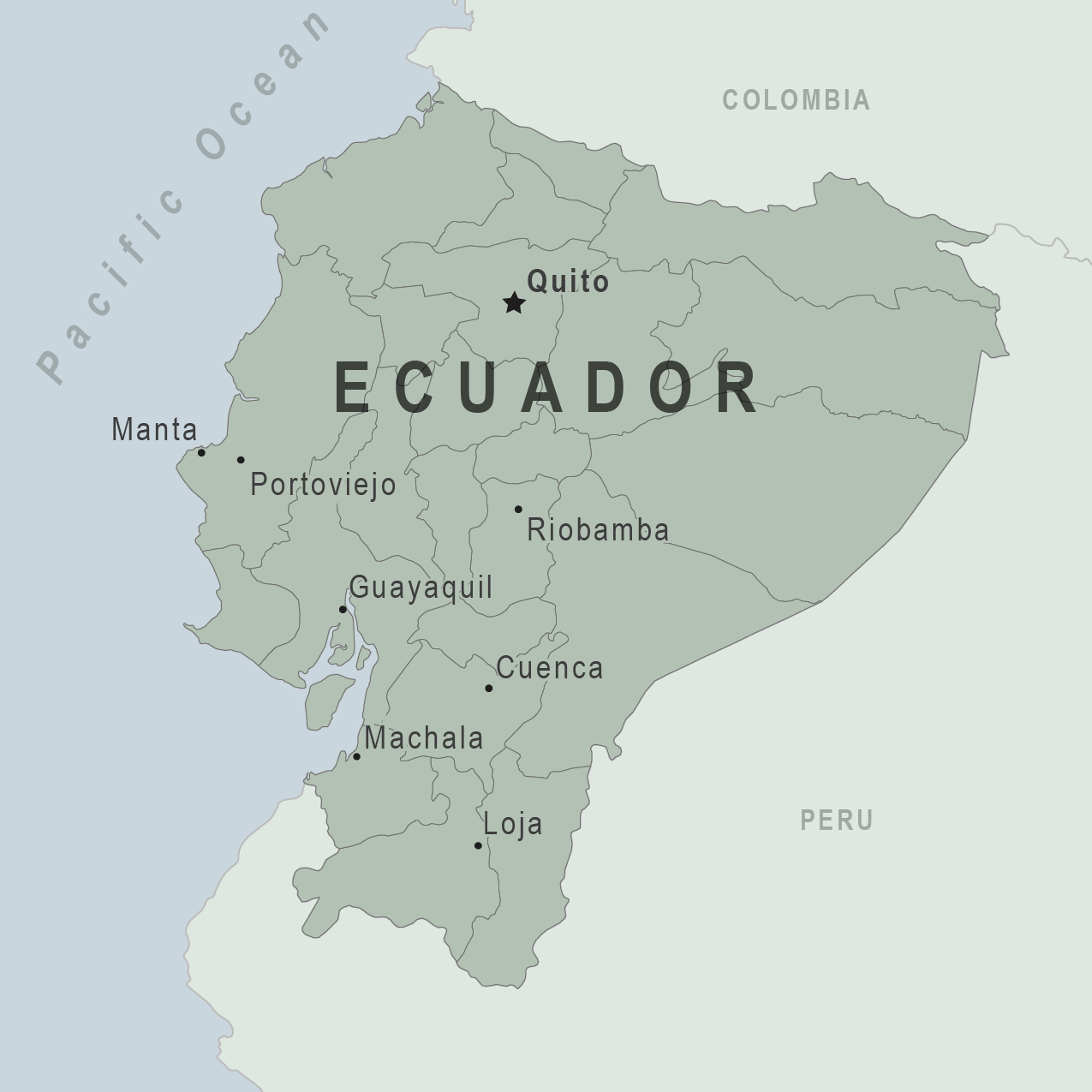
Guayaquil, Ecuador’s largest city and main port, is often the starting point for sailors and yachters. Located on the Guayas River, Guayaquil is a bustling metropolis with a vibrant maritime culture. The city’s modern marina facilities, such as the Puerto Santa Ana and the Yacht Club de Guayaquil, provide excellent services for visiting yachts. From here, sailors can prepare for their journey along the Ecuadorian coast or venture out to the Galápagos Islands.
2. Salinas: Ecuador’s Beach Resort
Salinas, located approximately 150 kilometers west of Guayaquil, is one of Ecuador’s premier beach resorts and a popular destination for yachters. The Salinas Yacht Club is a well-equipped marina that caters to international sailors. The region offers stunning beaches, excellent fishing, and vibrant nightlife. Sailing around Salinas, yachters can explore the nearby La Libertad and the picturesque village of Ayangue, known for its calm waters and seafood restaurants.
3. Bahía de Caráquez: The Eco-city
Bahía de Caráquez, or simply Bahía, is known for its commitment to eco-friendly practices and sustainable tourism. The Bahía Yacht Club offers secure anchorage and modern facilities. The city’s scenic waterfront, surrounded by lush hills and the Chone River, provides a tranquil setting for sailors. Nearby, the Machalilla National Park, home to the famous Isla de la Plata, offers exceptional opportunities for wildlife viewing, snorkeling, and diving.
4. Manta: A Thriving Port City
Manta is Ecuador’s second-largest port city and a vital hub for the country’s fishing industry. The city’s marinas, such as Marina Puerto Amistad, cater to yachts of various sizes. Manta’s coastline is dotted with beautiful beaches, including Playa Murciélago and San Lorenzo, perfect for relaxing and enjoying water sports. From Manta, sailors can visit the charming town of Montecristi, renowned for its Panama hats and traditional crafts.
5. Esmeraldas: Gateway to the North Coast
Esmeraldas, located in the northern part of Ecuador’s coastline, is a region rich in Afro-Ecuadorian culture and traditions. The Port of Esmeraldas and its yacht facilities provide access to some of the most unspoiled beaches in Ecuador, such as Playa Esmeraldas and Atacames. The region’s warm climate, lively music, and delicious seafood make it a delightful destination for sailors seeking a more laid-back atmosphere.
 Galápagos Islands: A Unique Maritime Adventure
1. Archipelago Overview
The Galápagos Islands, a UNESCO World Heritage site, are located approximately 1,000 kilometers off the coast of Ecuador. Comprising 18 main islands and numerous smaller islets, the archipelago is famous for its unique wildlife and pristine landscapes. The islands’ remote location and strict environmental regulations make them a challenging yet rewarding destination for yachters.
2. Arrival and Regulations
Before setting sail to the Galápagos, yachters must obtain the necessary permits and comply with stringent regulations designed to protect the fragile ecosystem. Conatct yacht agents gapapagos ( Javier ) The main entry points for yachts are the ports of Puerto Ayora on Santa Cruz Island, Puerto Baquerizo Moreno on San Cristóbal Island, and Puerto Villamil on Isabela Island. Each of these ports offers basic marina facilities, including mooring buoys, fuel, and provisioning services.
3. Santa Cruz Island: The Heart of the Galápagos
Santa Cruz Island, home to the largest town in the Galápagos, Puerto Ayora, is a central hub for yachters. The island offers various attractions, including the Charles Darwin Research Station, where visitors can learn about conservation efforts and see giant tortoises up close. Nearby, Tortuga Bay’s white sandy beaches and crystal-clear waters provide a perfect spot for swimming, kayaking, and snorkeling.
4. San Cristóbal Island: Rich in History and Wildlife
San Cristóbal Island, the easternmost island of the archipelago, is the administrative capital of the Galápagos. Puerto Baquerizo Moreno, the main town, offers a range of services for visiting yachts. The island’s highlights include La Lobería, a beach frequented by sea lions, and the Interpretation Center, which provides an excellent introduction to the islands’ history and ecology. Kicker Rock, a dramatic volcanic formation off the coast, is a popular dive site teeming with marine life.
5. Isabela Island: The Largest Island
Isabela Island, the largest in the archipelago, is renowned for its diverse landscapes and abundant wildlife. Puerto Villamil, the main town, is a quaint settlement with a relaxed atmosphere. Visitors can explore the Sierra Negra volcano, one of the most active volcanoes in the Galápagos, and the Wall of Tears, a historic site built by prisoners in the mid-20th century. The island’s extensive wetlands are home to flamingos, marine iguanas, and other unique species.
6. Floreana Island: A Blend of History and Nature
Floreana Island, one of the smaller inhabited islands, has a fascinating history of early settlers and pirates. The island’s Post Office Bay, where sailors have left mail for over two centuries, is a charming stop for yachters. Floreana’s rich marine life and vibrant coral reefs make it an excellent destination for snorkeling and diving.
Challenges and Considerations
1. Navigational Challenges
Sailing in Ecuador, especially around the Galápagos, presents several navigational challenges. The region’s waters are known for their strong currents, variable winds, and occasional rough seas. Yachters must be well-prepared and have up-to-date navigational charts and equipment. Additionally, the presence of numerous marine protected areas requires careful planning to avoid restricted zones.
2. Environmental Regulations
The Galápagos Islands are one of the most protected marine areas in the world. Strict regulations are in place to minimize human impact on the fragile ecosystem. Yachters must adhere to guidelines regarding anchoring, waste disposal, and wildlife interactions. Engaging with local authorities and obtaining the necessary permits in advance is crucial to ensure compliance with these regulations.
3. Provisioning and Supplies
While the mainland offers ample opportunities for provisioning, the Galápagos Islands have limited resources. Yachters should stock up on essential supplies before departing for the archipelago. Fresh produce, fuel, and spare parts may be scarce or expensive in the islands, so thorough preparation is essential.
Conclusion
Sailing and yachting in Ecuador and the Galápagos Islands offer an unparalleled maritime adventure. From the vibrant coastal cities of mainland Ecuador to the remote and pristine beauty of the Galápagos, sailors are treated to a diverse range of experiences. The unique wildlife, stunning landscapes, and rich cultural heritage make Ecuador a must-visit destination for yachters. However, the region’s navigational challenges and stringent environmental regulations require careful planning and preparation. For those willing to embrace these challenges, the rewards are extraordinary—a chance to explore one of the most ecologically significant and visually stunning regions on the planet.
FLAG HISTORY OF COLOMBIA & ECUADOR
MARINAS
PANAMA POSSE SPONSORSHIP MARINAS
1. Puerto Lucia Yacht Club
- Location: La Libertad, Santa Elena
- Latitude/Longitude: -2.22455, -80.91189
- Contact Information:
- Phone: +593 4-278-2410
- Website: Puerto Lucia Yacht Club
- Email: info@puertolucia.com.ec
2. Salinas Yacht Club
- Location: Salinas, Santa Elena
- Latitude/Longitude: -2.20533, -80.98211
- Contact Information:
- Phone: +593 4-277-1610
- Website: Salinas Yacht Club
- Email: info@yachtclubsalinas.com
3. Marina Puerto Amistad
- Location: Bahía de Caráquez, Manabí
- Latitude/Longitude: -0.59812, -80.42280
- Contact Information:
- Phone: +593 5-269-1011
- Website: Marina Puerto Amistad
- Email: puertoamistad@yahoo.com
4. Marina Costa Rica
- Location: Manta, Manabí
- Latitude/Longitude: -0.94800, -80.72000
- Contact Information:
- Phone: +593 9-8275-5505
- Website: Marina Costa Rica
- Email: info@marinacostarica.com.ec
5. Puerto Bolivar
- Location: Machala, El Oro
- Latitude/Longitude: -3.26984, -79.98650
- Contact Information:
- Phone: +593 7-293-0011
- Website: N/A
- Email: N/A
6. Marina Yachting Ecuador
- Location: Guayaquil, Guayas
- Latitude/Longitude: -2.19600, -79.88200
- Contact Information:
- Phone: +593 4-228-5220
- Website: N/A
- Email: N/A
WEATHER
Swell
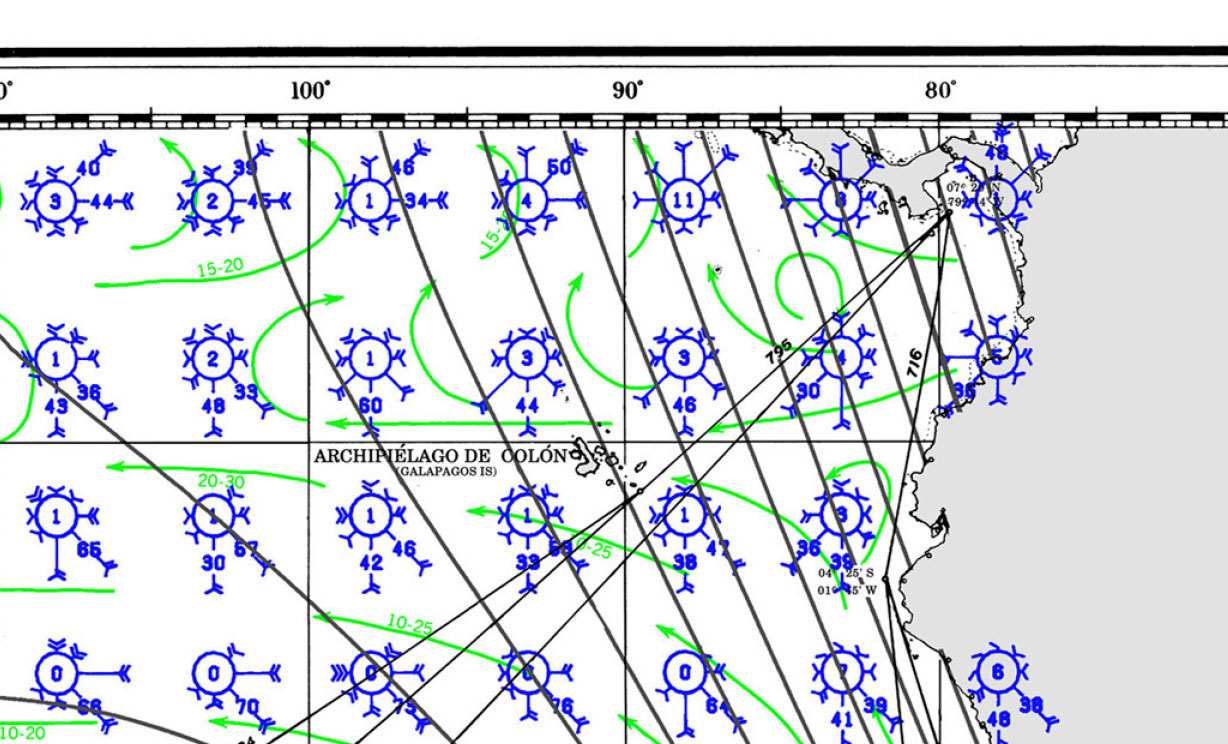
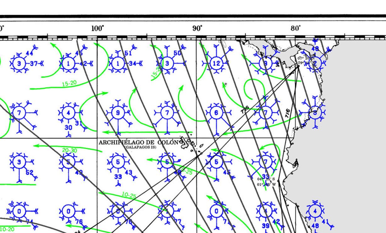
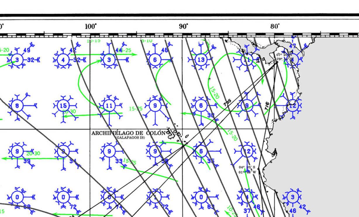
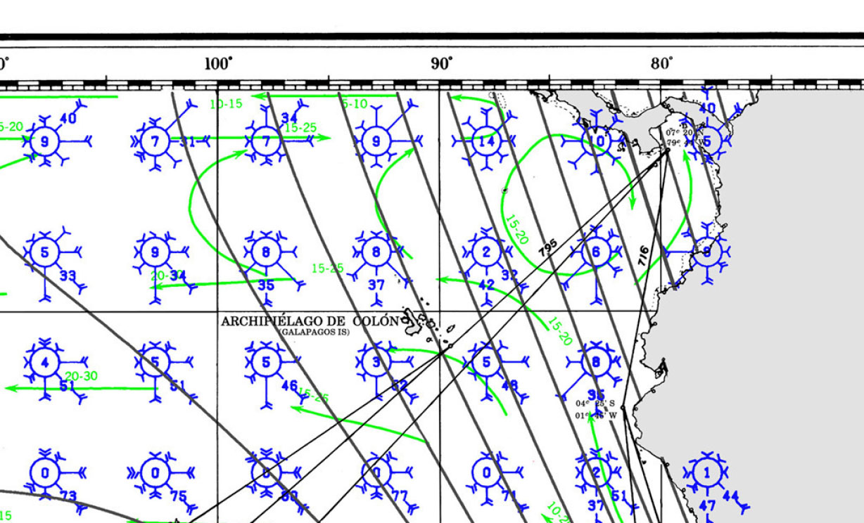
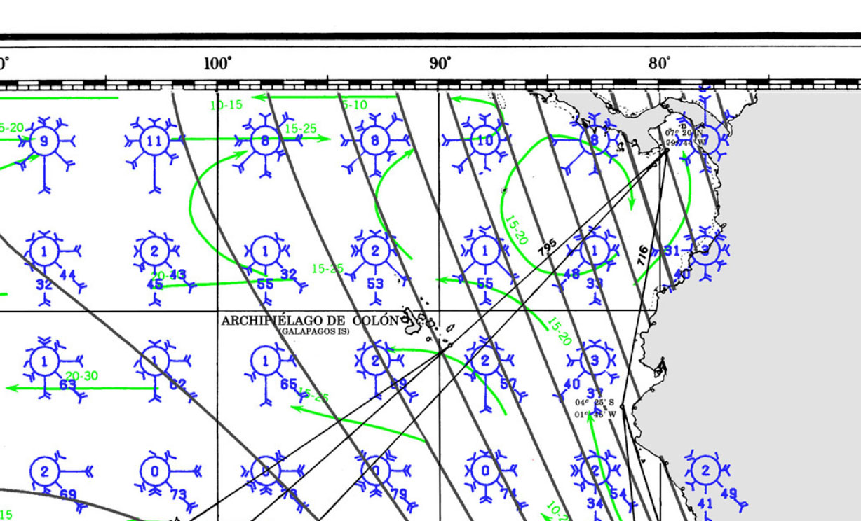
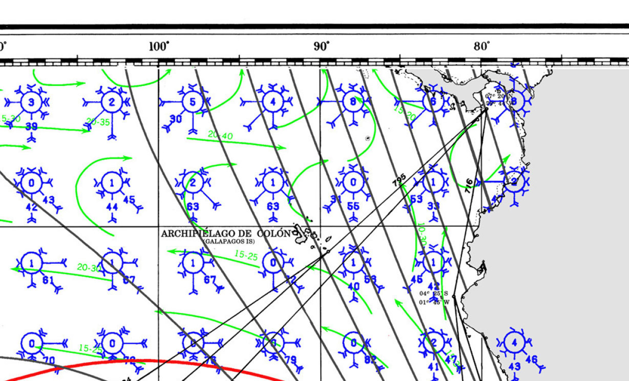
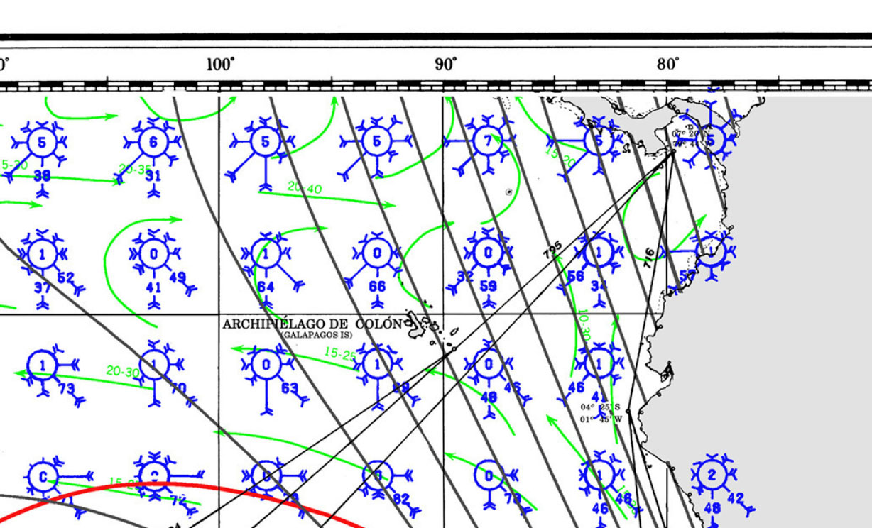
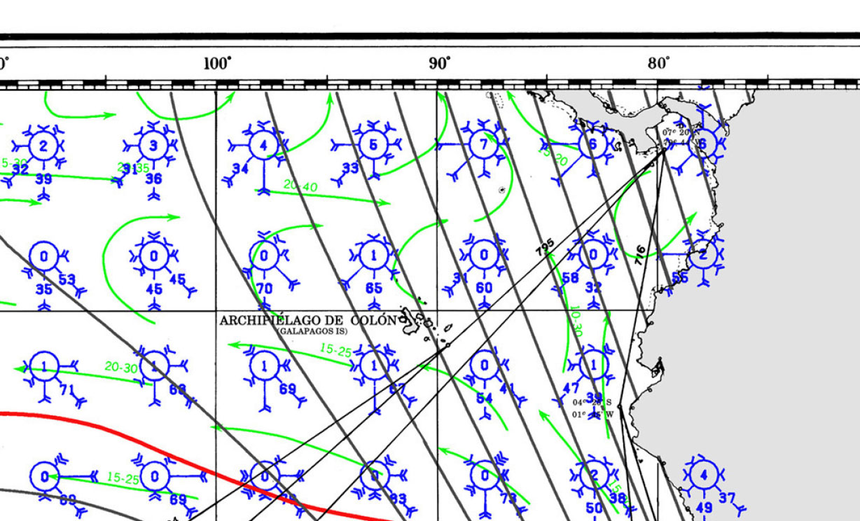
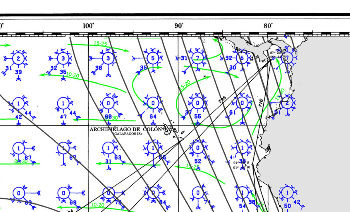
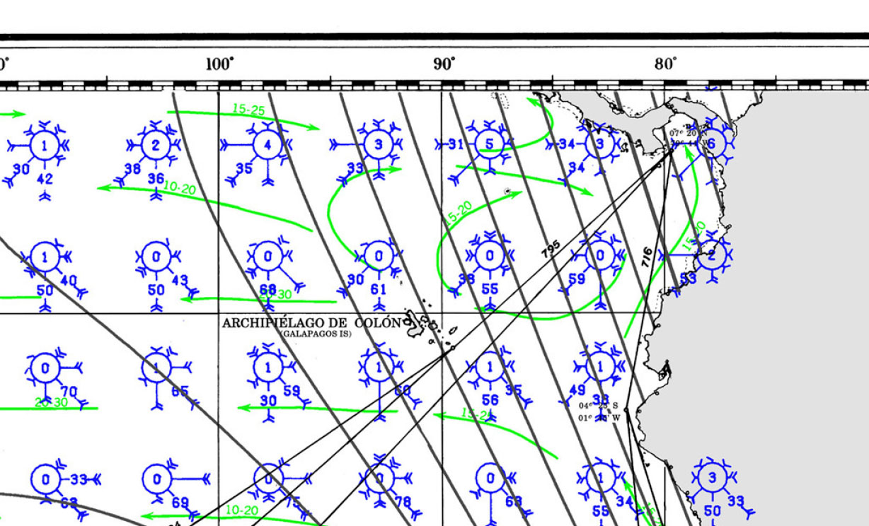
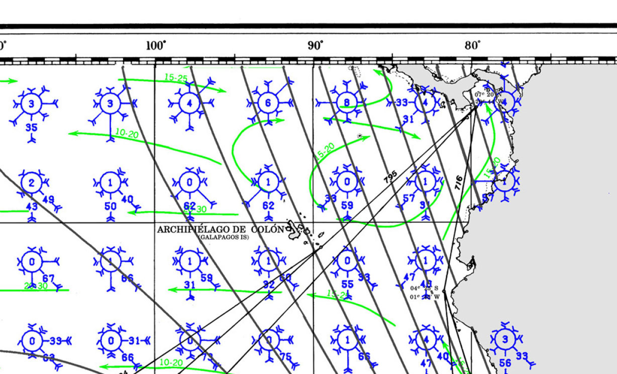
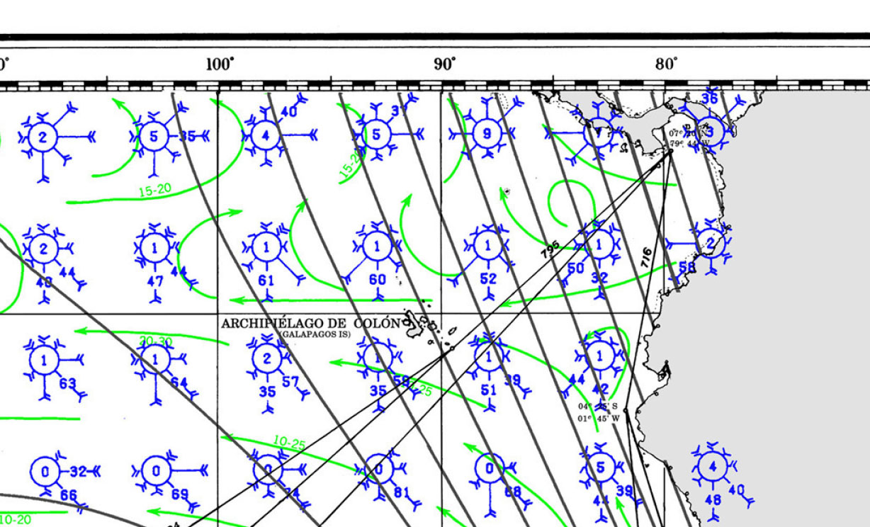
PILOT CHARTS
Pilot Charts depict averages in prevailing winds and currents, air and sea temperatures, wave heights, visibility, barometric pressure, and weather conditions at different times of the year. The information used to compile these averages was obtained from oceanographic and meteorologic observations over many decades during the late 18th and 19th centuries.The charts are intended to aid the navigator in selecting the fastest and safest routes with regards to the expected weather and ocean conditions. For an explanation of historic Colombian Climatology and how to read Wind-roses follow this link.
PORTS OF ENTRY
DOCUMENTS
| DOCUMENTATION | ECUADOR |
| Passport | Valid for at least 6 months; requires one blank page |
| Boat Documentation | Coast Guard Doc (Original) |
| Proof of Insurance | Liability |
| Crewlist | Required at checkin/out |
| Zarpe | Required at checkin/out |
| OFFICIAL PROCEDURES | CAN USE AN AGENT |
| Official Country Visa | NA if your country is on a list |
| Immigration Visa | |
| Required Permits | TIP / Customs via agent |
| Upon Arrival Visit: | Immigration; Customs; Port Authority |
| Upon Departure Visit: | Immigration; Customs; Port Captain |
| Entry & Exit Fees: | |
| Notes: | |
| OTHER | |
| Required Vaccinations | YELLOW FEVER |
| Pets | Vaccination Certificate |
| Currency: US DOLLAR |
PORTS OF ENTRY
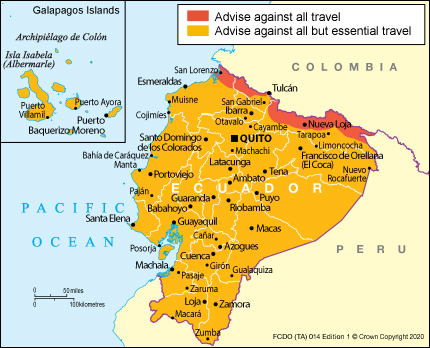
Esmeraldas, Guayaquil, Manta, Puerto Bolivar, La Libertad
| Crime Index | Safety Index | Corruption Index | Corruption Score | GDP | Pop (M) | Life Ex. | Cost of Living | Groc. week | Rest. $ | Loc.Purch.P. |
| 55.14 | 44.86 | 120/ 176 | 31% | $ 6,183.82 | 17.37 | 76.80 | 54.2 | 41.35 | 30.00 | 17.0 |
https://ec.usembassy.gov/
WEATHER
Prevalent trade winds bend along the coast from east really hard, especially along the northern eastern coast between late December through April. All year long however every near-shore winds will let up producing manageable jumps for vessels heading east. May through September, Colombia on the Caribbean side, faces long periods with hot and sticky conditions followed but thunderstorms and as a consequence you have minimal near-shore winds. Early fall can even produce westerlies. Winds and waves are significantly reduced closer to shore. As always do not sail on this coast on a schedule !

MUST SEE
MAINLAND MUST SEES
1. Quito Historic Center
- Location: Quito
- Latitude/Longitude: -0.22522, -78.51690
- Description:
- The historic center of Quito is one of the largest and best-preserved in the Americas, and it was declared a UNESCO World Heritage Site in 1978. It is filled with colonial churches, monasteries, museums, and squares that reflect the city’s rich history and culture. Key attractions include the Church of the Society of Jesus (La Compañía), Plaza Grande, and the Monastery of San Francisco. The architecture and cobblestone streets transport visitors back in time.
2. Cotopaxi National Park
- Location: Near Latacunga, Cotopaxi Province
- Latitude/Longitude: -0.68092, -78.43795
- Description:
- Cotopaxi National Park is home to the Cotopaxi volcano, one of the highest active volcanoes in the world, standing at 5,897 meters (19,347 feet). The park offers breathtaking landscapes, with opportunities for hiking, birdwatching, and climbing. The iconic snow-capped volcano is the main attraction, but the park also features unique Andean flora and fauna. Visitors can explore the Limpiopungo Lagoon and the various trails that offer stunning views of the volcano.
3. The Middle of the World (Mitad del Mundo)
- Location: San Antonio, Pichincha Province
- Latitude/Longitude: -0.00234, -78.45583
- Description:
- The Mitad del Mundo monument marks the equator line, where you can stand with one foot in the Northern Hemisphere and the other in the Southern Hemisphere. This popular tourist attraction includes a large monument, a small ethnographic museum, and various interactive exhibits about the equator. Nearby, the Intiñan Solar Museum offers a more precise location of the equator with demonstrations of equatorial phenomena.
4. Baños de Agua Santa
- Location: Tungurahua Province
- Latitude/Longitude: -1.39685, -78.42302
- Description:
- Baños is known for its natural hot springs, waterfalls, and adventure activities. Nestled in the Andes, it is a popular destination for both relaxation and thrill-seeking. The town is surrounded by lush green mountains and offers activities like zip-lining, canyoning, and bungee jumping. The nearby Tungurahua volcano adds to the dramatic landscape, and visitors can also enjoy the famous swing at the “End of the World” (La Casa del Arbol) for breathtaking views.
5. Cajas National Park
- Location: Azuay Province, near Cuenca
- Latitude/Longitude: -2.84117, -79.24612
- Description:
- Cajas National Park is a beautiful high-altitude park known for its hundreds of glacial lakes, rugged terrain, and unique ecosystems. It offers excellent hiking opportunities with trails that take you through stunning landscapes of mountains, valleys, and lagoons. The park is also home to diverse wildlife, including the Andean condor and spectacled bear. The park’s proximity to Cuenca makes it a popular day trip for nature lovers.
6. Guayaquil Malecón 2000
- Location: Guayaquil, Guayas Province
- Latitude/Longitude: -2.19102, -79.88068
- Description:
- The Malecón 2000 is a revitalized riverside promenade along the Guayas River in Guayaquil. It is a vibrant public space that combines history, culture, and recreation. The malecón features parks, gardens, fountains, museums, restaurants, and shopping areas. Key attractions include the La Rotonda monument, the Moorish Clock Tower, and the IMAX theater. It’s a great place for a leisurely walk with views of the river and the city skyline.
7. Cuenca Historic Center
- Location: Cuenca, Azuay Province
- Latitude/Longitude: -2.90055, -79.00453
- Description:
- Cuenca’s historic center is a UNESCO World Heritage Site known for its well-preserved colonial architecture, cobblestone streets, and charming plazas. The city is rich in history and culture, with highlights including the New Cathedral (Catedral Nueva), the Old Cathedral (Catedral Vieja), and the vibrant flower market. Cuenca is also famous for its Panama hats, which are actually made in Ecuador. The city’s blend of traditional and modern life makes it a must-visit.
8. Otavalo Market
- Location: Otavalo, Imbabura Province
- Latitude/Longitude: 0.23470, -78.26148
- Description:
- Otavalo Market is one of the largest and most famous indigenous markets in South America. Held in Plaza de los Ponchos, it offers a wide variety of handmade goods, including textiles, jewelry, crafts, and more. The market is a vibrant showcase of indigenous culture, with vendors from the surrounding Andean communities. Visitors can also explore the nearby Cotacachi town, known for its leather goods, and the beautiful Cuicocha Lagoon.
9. El Cajas National Park
- Location: Azuay Province, near Cuenca
- Latitude/Longitude: -2.83694, -79.22061
- Description:
- El Cajas National Park is known for its stunning landscapes, with over 270 lakes and lagoons, and is a haven for nature lovers and hikers. The park’s high-altitude ecosystems are home to unique flora and fauna, and the dramatic terrain provides breathtaking views. The park is easily accessible from Cuenca, making it a popular destination for day trips and nature excursions.
10. Parque Nacional Machalilla
- Location: Manabí Province, near Puerto López
- Latitude/Longitude: -1.56338, -80.81694
- Description:
- Machalilla National Park is one of Ecuador’s most important protected areas, offering both terrestrial and marine biodiversity. The park includes beaches, dry forests, and the famous Isla de la Plata, often called the “Poor Man’s Galápagos” for its similar wildlife. Visitors can explore pristine beaches like Los Frailes, hike through the tropical dry forest, and go whale watching from June to September. The park is a hidden gem for nature enthusiasts.
GALAPAGOS MUST SEE
1. Bartolomé Island
- Latitude/Longitude: 0°17’20.8″S 90°33’05.0″W
- Why Visit: Bartolomé is famous for its iconic Pinnacle Rock, a dramatic volcanic formation that rises sharply from the sea. The island offers breathtaking panoramic views from the summit, where you can observe the striking contrast between the red, orange, black, and green volcanic landscapes. The surrounding waters are a haven for marine life, making it a prime spot for snorkeling with Galápagos penguins, sea lions, and a variety of colorful fish.
- Best Time to Visit: December to May, when the waters are warmer and calmer, providing optimal snorkeling conditions.
2. Isabela Island (Volcán Sierra Negra)
- Latitude/Longitude: 0°49’12.0″S 91°05’36.0″W
- Why Visit: Isabela Island, the largest in the Galápagos, is home to the Sierra Negra Volcano, which boasts one of the largest volcanic craters in the world. Hiking to the crater’s edge offers spectacular views of the caldera and surrounding lava fields. The island is also rich in biodiversity, with giant tortoises, land iguanas, and flamingos inhabiting its varied ecosystems.
- Best Time to Visit: June to December, when the weather is cooler and the hiking conditions are more favorable.
3. Santa Cruz Island (Charles Darwin Research Station)
- Latitude/Longitude: 0°44’30.0″S 90°18’30.0″W
- Why Visit: The Charles Darwin Research Station on Santa Cruz Island is a must-visit for those interested in conservation and the natural history of the Galápagos. The station is instrumental in the protection and study of the islands’ unique flora and fauna, including the breeding program for the endangered Galápagos giant tortoise. Visitors can learn about the ongoing efforts to preserve the islands’ biodiversity and meet some of the tortoises up close.
- Best Time to Visit: Year-round, as the station is always active with research and conservation projects.
4. Fernandina Island (Punta Espinoza)
- Latitude/Longitude: 0°15’00.0″S 91°26’00.0″W
- Why Visit: Fernandina is the youngest and most pristine of the Galápagos Islands, offering a glimpse of the volcanic forces that continue to shape the archipelago. Punta Espinoza is famous for its large colonies of marine iguanas, which bask on the dark lava rocks. The island is also home to flightless cormorants, Galápagos penguins, and sea lions, making it a haven for wildlife enthusiasts.
- Best Time to Visit: December to May, when marine life is most active and the weather is warm.
5. San Cristóbal Island (Kicker Rock)
- Latitude/Longitude: 0°48’14.0″S 89°30’18.0″W
- Why Visit: Kicker Rock, or León Dormido, is an iconic rock formation off the coast of San Cristóbal Island. The two vertical rocks rise dramatically from the ocean, creating a narrow channel that is a popular snorkeling and diving site. The waters around Kicker Rock are teeming with marine life, including hammerhead sharks, rays, and sea turtles, making it a thrilling experience for underwater adventurers.
- Best Time to Visit: December to May, when the seas are calmer and visibility is better for snorkeling and diving.
6. Genovesa Island (Darwin Bay)
- Latitude/Longitude: 0°19’30.0″N 89°57’30.0″W
- Why Visit: Genovesa, known as “Bird Island,” is a paradise for bird watchers. Darwin Bay is a submerged caldera surrounded by steep cliffs, providing a unique habitat for numerous bird species. Red-footed boobies, Nazca boobies, and frigatebirds are among the many species that can be observed here. The bay is also a great spot for snorkeling, with a vibrant underwater ecosystem.
- Best Time to Visit: Year-round, with the breeding season for many birds occurring from February to October.
7. Floreana Island (Post Office Bay)
- Latitude/Longitude: 1°14’40.0″S 90°25’10.0″W
- Why Visit: Floreana Island is steeped in history and mystery, with Post Office Bay being one of its most famous sites. Here, you can participate in a centuries-old tradition of leaving and picking up postcards without stamps, a practice started by whalers in the 18th century. The island also offers opportunities to explore pirate caves, visit the black sand beaches, and snorkel with sea lions and turtles.
- Best Time to Visit: December to May, when the water conditions are ideal for snorkeling.
8. Santa Cruz Island (Tortuga Bay)
- Latitude/Longitude: 0°45’30.0″S 90°19’30.0″W
- Why Visit: Tortuga Bay is one of the most beautiful beaches in the Galápagos, known for its pristine white sands and turquoise waters. The beach is a nesting site for the black sea turtles, which come ashore to lay their eggs. Visitors can also spot marine iguanas, blue-footed boobies, and pelicans. The calm waters of the nearby mangroves are perfect for kayaking and observing the rich marine life.
- Best Time to Visit: January to April, when sea turtles are nesting, and the weather is warm.
9. Isabela Island (Tintoreras)
- Latitude/Longitude: 0°57’45.0″S 90°58’30.0″W
- Why Visit: The Tintoreras islets, located off the coast of Isabela Island, are named after the white-tipped reef sharks that are commonly found resting in the shallow channels. The islets are a prime spot for observing Galápagos penguins, marine iguanas, and sea lions. Snorkeling here offers encounters with a variety of marine species, including sharks, rays, and colorful fish.
- Best Time to Visit: December to May, when the sea conditions are calm, and marine life is abundant.
10. Española Island (Gardner Bay)
- Latitude/Longitude: 1°22’00.0″S 89°40’00.0″W
- Why Visit: Gardner Bay on Española Island boasts a stunning white sand beach that stretches for miles, offering a tranquil setting for relaxation and wildlife observation. The bay is frequented by sea lions, which can often be seen lounging on the beach or playing in the surf. The nearby Gardner Islet is a great spot for snorkeling, with a chance to see reef sharks, rays, and colorful fish.
- Best Time to Visit: December to May, when the weather is warm, and the sea conditions are ideal for snorkeling.
11. Santa Fe Island
- Latitude/Longitude: 0°50’00.0″S 90°03’00.0″W
- Why Visit: Santa Fe Island is renowned for its unique species of land iguanas, which are larger and lighter-colored than those found on other islands. The island’s lush vegetation, including the towering Opuntia cacti, provides a striking contrast to the arid landscapes of the rest of the archipelago. Snorkeling in the clear waters around Santa Fe offers encounters with sea lions, rays, and a variety of fish.
- Best Time to Visit: December to May, when the waters are warm and visibility is excellent for snorkeling.
12. North Seymour Island
- Latitude/Longitude: 0°24’00.0″S 90°17’00.0″W
- Why Visit: North Seymour Island is a bird-watcher’s paradise, home to large colonies of blue-footed boobies, frigatebirds, and swallow-tailed gulls. The island’s flat terrain makes it easy to explore on foot, with trails leading through the breeding sites of these fascinating birds. The surrounding waters are also rich in marine life, making it a great spot for snorkeling.
- Best Time to Visit: June to December, when the seabirds are nesting and the cooler weather makes hiking more comfortable.
13. Rabida Island
- Latitude/Longitude: 0°24’30.0″S 90°42’00.0″W
- Why Visit: Rabida Island is known for its striking red sand beaches, the result of the island’s iron-rich volcanic soil. The island is a haven for bird species, including flamingos, pelicans, and white-cheeked pintail ducks, which can be seen around the saltwater lagoon. The surrounding waters are excellent for snorkeling, with vibrant coral reefs and a variety of fish species.
- Best Time to Visit: December to May, when the weather is warm, and marine life is abundant.
14. Isabela Island (Elizabeth Bay)
REPAIRS AND SERVICE PROVIDERS
MAIN LAND1. Astinave EP (Astilleros Navales Ecuatorianos)
2. Marina Puerto Lucia Yacht Club
3. Salinas Yacht Club
4. Marina Puerto Amistad
5. Marina Costa Rica
6. Astilleros Navales (ASTINAVE)
7. Puerto Bolivar Shipyard
|
GALAPAGOS1. Nautica Galápagos
2. Servinautic Galápagos
3. Galápagos Marine Services
4. Astilleros Galápagos
5. Nautic Repairs San Cristóbal
|
EMERGENCIES AND SAR INFO
MRCC Guayaquil
Type: MRCC, Country: Ecuador, SRR: SRR ECUADOR
Latitude, Longitude:
(-2.1839159,-79.8833160)
Telephone:
593-4-2321602
Email:
costera_digmer@armadaecuador.com
Fax:
593-4-2324714
MRCC Guayaquil:
INMARSAT:
Telex:
308-43325 HCGRAD ED, 308-42512 ESTHCG ED
MRCC Ecuador (Guardacostas)
Type: MRCC, Country: Ecuador, SRR: SRR ECUADOR
Latitude, Longitude:
(-2.166670084,-79.90000153)
Telephone:
+593 4 2480812 alternate:
+593-4-2321602
Email:
Fax:
+593 4 2480176
https://www.coguar.dirnea.org
INMARSAT:
AL SUR DE LA CIUDAD DE GUAYAQUIL
coguar@armada.mil.ec
coguar_ope@armada.mil.ec
costera_digmer@armadaecuador.com
CHARTS
AIDS TO NAVIGATION
- 608 Guayaquil to Valparaiso
- 503 Mexico to Ecuador
- 124 North Atlantic Ocean (Southwestern Sheet)
- 21036 Golfo Dulce to Bahia de Paita
- 22004 Cabo de San Francisco to Paita (Ecuador and Peru)
- 22000 Archipielago de Colon (Galapagos Islands)
GOOD NAUTICAL
Please sign up with Good Nautical for Anchorages, Marinas, and Ports of Entry Information for Ecuador.

Who, what, how do I sign up for charts and other info @ Good Nautical!?
It’s in your welcome email