Entry to the Sea of Cortez
We entered the Sea of Cortez at Cabo San Lucas in April after sailing down the Pacific side of Baja California. Instantly, the warm waters welcomed us.
The water temperature is our guide in the winter months and dictates our positions.
Why Visit the Sea of Cortez?
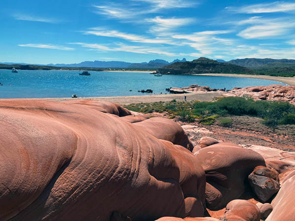
Dubbed the “aquarium of the world” by Jacques Cousteau, the Sea of Cortez rivals the Galápagos Islands in biodiversity. Its stunning desert landscapes, sandy beaches, vibrant marine life, and remote fishing villages make it a paradise for snorkelers, divers, whale watchers, bird enthusiasts, and adventurers. Whether you seek solitude, charming Mexican towns, or thrilling wildlife encounters, this region offers something special.
Seasonal Sailing Tips
To make the most of the Sea, follow the seasons:
- May to November: Use the south winds to sail north, spending summer and hurricane season in the upper Sea, north of Santa Rosalia.
- Hurricanes do enter the seas especially in la paz and travel as far north as Puerto escondido
- November to April: Ride the north winds back south.
This seasonal rhythm allows for warm-water snorkeling in late spring and summer, with air temperatures around 30-35°C 86-95 F, and cooler winter hikes on the islands, with temperatures ranging from 18-25°C. 65-77 F Be prepared for the upper Sea’s extremes—hot summers and chilly winter nights.
Navigational Challenges
The Sea’s localized high winds, including Chubascos, Coromels, and Elefantes, demand vigilance. These unpredictable summer winds, coupled with strong Northern winds in winter, require sturdy anchoring techniques and reliable gear. With good planning and weather monitoring so can find safe havens among the many breathtaking anchorages. Most offer excellent sand holding, caution i at Ísla San Esteban and Ísla Isabel.
Wildlife and Cultural Highlights
Migratory birds and whales delight enthusiasts between January and April, though some species remain year-round. La Paz’s whale museum (currently relocating) provides valuable insights into the region’s marine life. For literary explorers, John Steinbeck’s The Log from the Sea of Cortez offers a compelling account of his 1941 expedition through this extraordinary ecosystem.
Exploring the Northern Sea
The Northern Sea of Cortez remains less frequented, with many cruisers venturing no further than La Paz. Beyond Puerto Escondido and Bahía Concepción lies a more remote, off-grid experience requiring careful provisioning. There are limited ATMs between Santa Rosalia and San Felipe, so bring sufficient cash. The secluded anchorages, vibrant fishing villages, and charming towns make the journey worthwhile.
Favorite anchorages included Bahía de Los Ángeles, Bahía Kino, Ísla Tiburón, Ísla Ángel de la Guarda, Ísla Salsipuedes, and Ísla San Esteban. For boat maintenance or storage, Puerto Peñasco’s Cabrales Boatyard offers affordable rates with Ocean Posse discounts.

>
CABO SAN LUCAS TO PUERTO PEÑASCO ~ 700 nm
- Cabo San Lucas to Los Frailes 41.8 nm
- Los Frailes to Bahia de los Muertos 43.9 nm
- Bahia de los Muertos to La Paz 52 nm
- La Paz to Bahía de San Gabriel Cove 17.8 nm
- San Gabriel Cove to Caleta Partida 11 nm
- Caleta Partida to Isla San Francisco 21 nm
- Isla San Francisco to Bahia Evaristo 9.8 nm
- Evaristo to Aqua Verde 42 nm
- Aqua Verde to Puerto Escondido 23 nm
- Puerto Escondido to Loreto 14 nm
- Loreto to Caleta de San Juanico 23.4 nm
- Caleta de San Juanico to Bahia Concepcion 43 nm
- Bahia Concepcion to Santa Rosalia 48.9 nm
- Santa Rosalia to Bahia San Francisquito 79 nm
- Bahia San Francisquito to Bahia las Animas 32.2 nm
- Bahia las Animas to Bahia los Angeles 19.8 nm
- Bahia Los Angeles to Bahia Refugio 42.1 nm
- Bahia Refugio to Puerto Penasco 107.2 nm
<!– lats longs –>
Seafarers typically move quickly from Cabo or San Jose de Cabo and head for La Paz, a magnetic cruising port and epicenter of the lower sea of Cortes for provisions, culture and food. The next sizable city on the Baja side is Loreto close to 150 miles north, with some of the most spectacular cruising spread out between. From Santa Rosalia north to the Bahia de Los Angeles area vistas and locations gets more remote and you tend to see less cruising yachts. In the northern sea Puerto Peñasco is a cruiser friendly spot to put up and haul out with most work done by cruisers themselves. The proximity to Arizona / US Border for parts makes this a very popular place to haul out.
Weather in the Sea of Cortes is very much seasonal.
The prime seasons for exploring this area under sail is from late Oct to Dec ( Fall ) and Apr to Jun ( Spring )
Jan – Mar suffer from strong Northerners💨, cold and sometimes gale force winds of 30+ knots that originate in winter high pressure in the southwestern US, and blow the full length of the Sea, kicking up some serious short period square wind waves and swell. They can blow for 2-4 days, with short periods of lovely cool weather in between.
Jul – Oct is the Hurricane Season 🌀 with intense heat and humidity of summer. Summer SE/Tropical Storm Season – hot and humid
There is a general rule of following the water temperature when cruising in the sea. Too cold ? Head south – Too warm ? Head north !
WINDS
CURRENTS
SWELL AND WAVES