 Sailing the Coast of Brazil – A Captain’s Guide
Sailing the Coast of Brazil – A Captain’s Guide
I. Introduction
Brazil’s immense coastline, stretching more than 4,600 nautical miles from the border of French Guiana in the north to Uruguay in the south, is one of the most diverse and under-cruised coastlines in the world. For captains plotting a course across the South Atlantic, whether westbound from Africa or staging for a Caribbean season, Brazil presents a long but rewarding transit rich in culture, weather challenges, and distinct navigational zones.
The coastline traverses three climate bands, equatorial, tropical, and subtropical, with varying sea states, infrastructure, and anchorages. The Brazilian coast includes busy ports, pristine islands, mangrove deltas, colonial towns, and vibrant metropolises. Accurate charts, updated weather routing, and careful planning are essential for a successful passage.
While language and bureaucracy can present hurdles, Brazil offers generous maritime hospitality, an improving marina network, and opportunities to connect with friendly locals and explore rarely visited anchorages. With good preparation, a flexible schedule, and respect for the forces of nature, captains can enjoy a memorable voyage along one of the longest uninterrupted cruising grounds in the Southern Hemisphere.
📌 Planning Notes for Captains
• Northbound: You’ll often be sailing against wind and current—especially hard work south of Salvador.
• Southbound: Best done between July and December, with more favorable winds and current push.
• Frontal Systems: Always monitor barometric pressure and satellite forecasts. Cold fronts can race north past Rio in less than 48 hours.
• Swell: From Cabo Frio southward, long-period southerly swells are common—especially dangerous in harbor bars like Itajaí or Rio Grande
A) North Coast: From Oiapoque to Fortaleza
The north coast of Brazil—stretching from the French Guiana border at Oiapoque to Fortaleza—is wild, tropical, and dominated by vast river systems, sediment-heavy waters, and mangrove shorelines. It’s remote and sparsely populated, making it suitable for experienced captains with solid prep and patience for bureaucracy and tides.
General Conditions:
• Heavy rainfall, especially from January to May.
• Strong tidal currents—often exceeding 3 knots in rivers and estuaries.
• Poor visibility due to suspended sediment near the coast.
• Few marinas or services—this is a low-infrastructure zone.
• Equatorial sun, insects, and squalls demand protection and caution.
Macapá and the Amazon Delta:
• Approached via the mouth of the Amazon River (Rio Amazonas).
• Strong tidal flows (up to 6 knots) and muddy waters make navigation tricky.
• Use slack tide and daylight for entry.
• Charts can be unreliable—supplement with satellite imagery (Google Earth or SASPlanet).
• Expect bureaucratic delays for clearance.
• Fuel and basic supplies are available, but no real marina infrastructure.
Belém (optional detour):
• Situated on the southern Amazon estuary.
• A larger city with some maritime support, though not common for yacht entries.
• Offers deeper access into the Amazon basin and interior rivers.
Santarém (via Amazon):
• Inland detour for adventurous vessels.
• Cultural immersion and jungle experiences, but with logistical and current-related challenges.
• Expect intense rain, bugs, and river hazards (debris, logs, floating nets).
• Not a coastal route—best for upriver expeditions.
São Luís (Maranhão):
• Historic colonial town and UNESCO site.
• Surrounded by mudflats, tidal creeks, and strong bay currents (~4 knots).
• Entry should be made on a rising tide and in daylight.
• Anchorage in protected channels is possible; basic provisions available.
• Charming but not well equipped for yachts.
Delta do Parnaíba:
• One of Brazil’s only true river deltas.
• A labyrinth of channels, mud banks, and sandbars.
• Navigation is possible for shallow-draft vessels with local knowledge.
• Highly tidal, prone to shifting bottom features.
• Visually stunning, but not advised without scouting or drone recon.
Fortaleza (Ceará):
• The first fully equipped port along the north coast.
• Marina Park Hotel offers proper berths, fuel, water, and security.
• Good provisioning, haul-out access, and entry formalities.
• Anchorages outside the breakwater are possible but can be rolly.
• SE trades become more reliable from this latitude onward.
• Urban crime exists—stick to marina areas and avoid walking at night with valuables.
Hazards Specific to the North Coast:
• Floating vegetation, logs, and debris (especially near the Amazon).
• Shallow estuary bars that shift after storms or during spring tides.
• Unlit fishing canoes and nets that stretch across river mouths.
• Poor chart accuracy in lesser-trafficked areas.
Captain’s Tips:
• Carry plenty of fuel, a strong dinghy, and jerry jugs.
• Download offline satellite imagery for visual charting.
• Plan moves around tides—timing is crucial.
• Be patient with authorities—formalities are thorough but typically polite.
• Learn some Portuguese phrases for smooth interactions.
B) Northeast Coast: Fortaleza to Salvador
This section of the Brazilian coast is known for its sunshine, reliable trade winds, and accessible anchorages. It’s ideal for southbound sailing with consistent wind and manageable sea states. From Fortaleza to Salvador, cruisers can enjoy open-water passages interspersed with culturally rich coastal cities.
General Conditions:
• Trade winds from the SE to E dominate, averaging 10–20 knots.
• Dry season from June to November provides the best cruising window.
• Atlantic swell is long-period and usually 1–2.5 meters, with moderate chop.
• Tidal ranges are modest but stronger near river mouths.
Natal (Rio Grande do Norte):
• Mid-sized city with protected anchorage behind breakwaters near the Iate Clube do Natal.
• Enter during daylight to avoid reefs and unmarked hazards.
• Provisioning is easy; fuel may require jerry can delivery.
• Good rest stop, though marina options are limited.
Recife (Pernambuco):
• Historical and cultural capital with extensive reef systems offshore.
• Caution: reefs extend miles from shore—accurate navigation is crucial.
• Porto do Recife has a small marina and services.
• Customs and immigration available.
• Entry subject to currents; time entry on a rising tide.
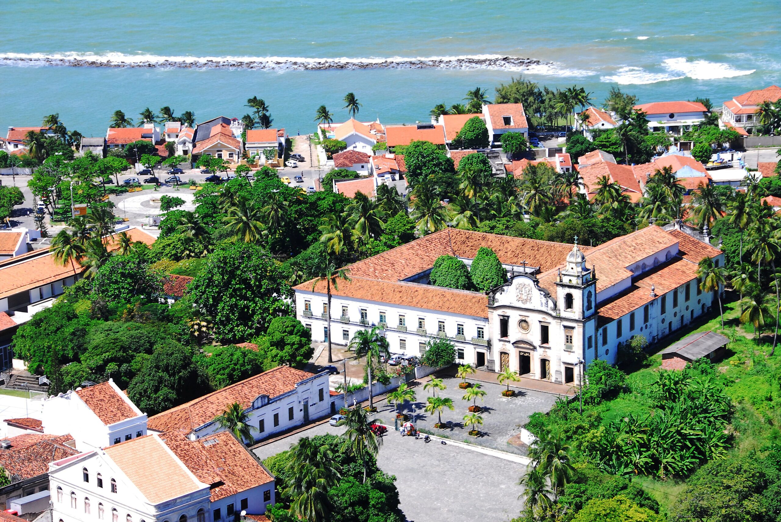
• Ashore, enjoy colonial Olinda and Recife Antigo for architecture and local culture.
Maceió (Alagoas):
• A laid-back beach city with clear waters and attractive coastlines.
• No formal marina, but anchorages behind reef-protected bays offer security.
• Access to basic provisions, fuel by taxi or drums.
• Protected lagoons nearby can be used for calm overnight stops.
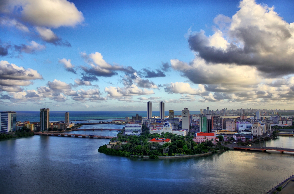
Salvador (Bahia):
• The first major yachting hub heading south. Located in Baía de Todos os Santos (Bay of All Saints), which offers dozens of anchorages and several marinas.
• Entry is straightforward with deep channels and well-charted waters.
• Recommended marinas:
◦ Marina Pier Salvador
◦ Terminal Náutico da Bahia
◦ Bahia Marina (higher end)
• Full range of services: fuel, haul-out, repairs, provisioning, laundry, Wi-Fi.
• Clearance available here and often preferred due to efficiency.
• Ashore: Explore the Pelourinho district, Afro-Brazilian music, capoeira, and local cuisine.
Anchorages and Cruising:
• Baía de Todos os Santos is Brazil’s largest natural bay.
◦ Offers calm waters, islands to explore, and multiple well-sheltered anchorages.
◦ Watch for ferries, cargo ships, and unlit fishing gear at night.
◦ Weekends can get busy with local traffic and jet skis.
Hazards & Considerations:
• Reefs are extensive and often unmarked—enter only with high sun and good visibility.
• In urban areas, dinghy and gear theft can be a concern—lock up everything.
• Some fishing nets may extend from shore well past charted areas—be vigilant, especially when motorsailing at night.
Captain’s Notes:
• This region is a prime opportunity to make good southbound progress.
• Expect consistent beam-to-broad reach conditions in SE trades.
• Plan ahead for fuel at Recife or Salvador; other towns may not have marina pumps.
• Salvador is an excellent stop for resupply, maintenance, and crew changes.
• Allow a few days to explore Salvador and its islands—it’s the cultural soul of coastal Brazil.
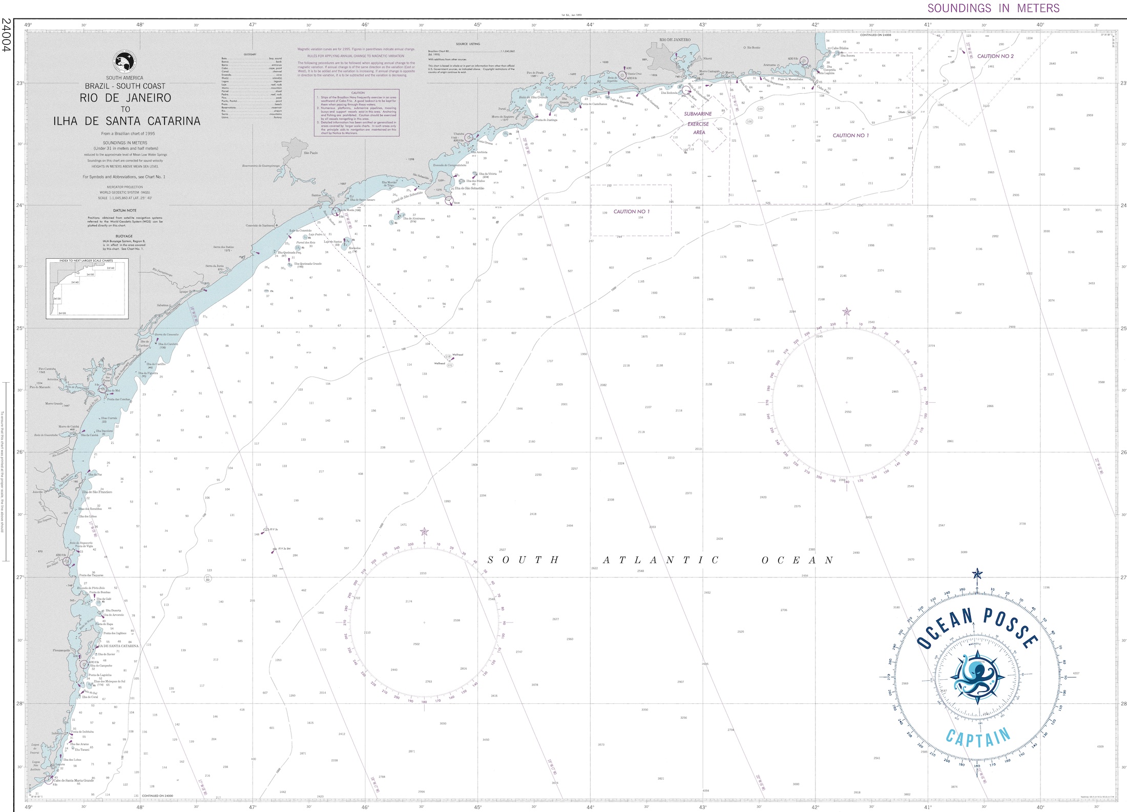
C) Southeast Coast: Rio de Janeiro to Florianópolis
The coastline from Rio southward transitions from tropical to subtropical, with a marked increase in weather variability, commercial traffic, and frontal systems. While it may lack the idyllic cruising density of Ilha Grande, this region delivers serious sailing, hidden gems, and excellent service options in urban centers.
General Weather and Conditions:
• Cold fronts arrive every 5–10 days between April and October, often with little warning.
• Winds shift from NE/E to SW rapidly with the passage of fronts.
• SW swell following a front can reach 2.5–4 meters offshore.
• Summer (Dec–Mar) is the most stable season, with calm mornings and afternoon sea breezes.
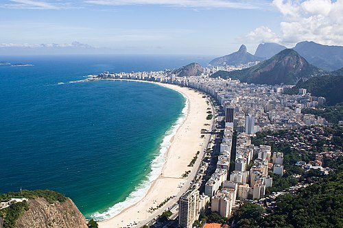
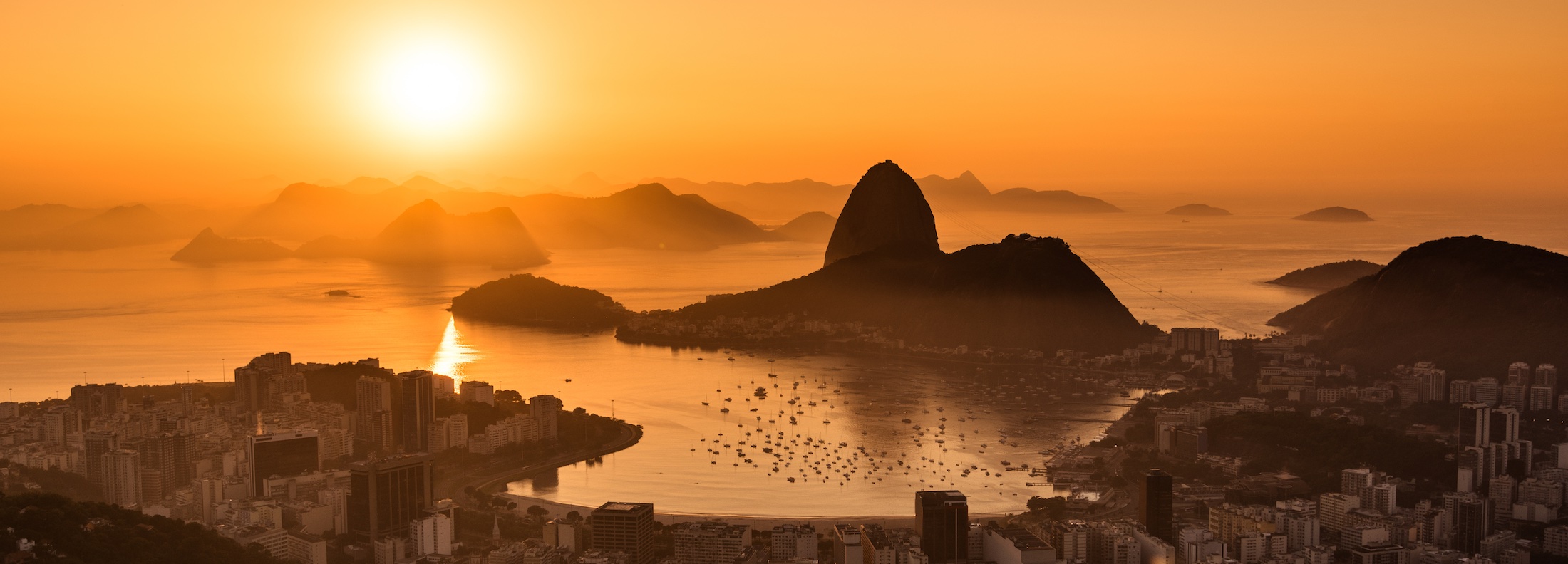
Rio de Janeiro:
• A world-famous city with a striking coastline.
• Marina da Glória offers downtown berthing and services.
• Popular anchoring options include:
◦ Urca (below Sugarloaf Mountain)
◦ Botafogo Bay
◦ Enseada de Jurujuba (across Guanabara Bay)
• Be cautious of:
◦ Wake from ferries and commercial ships
◦ Urban theft (lock your dinghy, don’t leave gear unattended)
• Shore leave is rich: visit Christ the Redeemer, Lapa, Niterói Contemporary Art Museum, and colonial forts.
Ilhabela (São Paulo):
• One of Brazil’s premier sailing destinations.
• Dozens of protected anchorages with lush jungle and mountain backdrops.
• Yacht Club Ilhabela is a key stopover with facilities and events.
• Waterfalls and hiking trails abound.
• Beware of accelerated winds and currents in the São Sebastião Channel.
• Local marine parks require anchoring permits in select bays.
Cananéia & Ilha Comprida:
• A wild estuarine system teeming with wildlife.
• Navigation involves shifting sandbars and shallow channels—not recommended without updated charts and good visibility.
• A great place for those seeking silence and solitude.
• Good storm refuge during the season.
Paranaguá & Ilha do Mel (Paraná):
• Paranaguá is a major commercial port with limited options for yachts.
• Ilha do Mel is nearby—a laid-back island popular with locals and backpackers.
• Channel entrance can be rough—enter on a rising tide in settled weather.
• Anchorage available behind the island.
• Good access to fresh water, internet, and groceries.
Florianópolis (Santa Catarina):
• Capital of Santa Catarina and one of Brazil’s most cruiser-friendly cities.
• Options include:
◦ Baía Norte: Sheltered anchorages and proximity to Yacht Club of Santa Catarina.
◦ Lagoa da Conceição: Scenic but shallow—suitable for shallow-draft boats.
• Offers:
◦ Haul-out and marine service yards
◦ Strong sailing culture
◦ Surfing, hiking, and modern conveniences
• Expect crowds and marina demand during Brazilian summer holidays (Dec–Feb).
Navigation Tips:
• Stay well offshore around commercial ports—shipping lanes are dense.
• Radar and AIS are highly recommended.
• Fishing gear and buoys often float unlit 3–10 nm offshore.
• Plan bar crossings at Cananéia, Paranaguá, and Lagoa dos Patos around calm swell and tides.
This stretch of coast blends urban convenience and natural beauty. While not as tropical as Bahia or Ilha Grande, it offers some of the best service infrastructure and access to haul-outs, supplies, and repairs before heading into Brazil’s southern reaches or preparing for the hop to Uruguay or Argentina.
 D)South Coast to Uruguay Border
The southernmost stretch of Brazil’s coastline—from Florianópolis to Chuí—is remote, raw, and influenced by Southern Ocean weather systems. This is a transition zone from subtropical to temperate sailing, with colder waters, fewer anchorages, and a thinner population density.
While not a primary cruising destination, this route is essential for yachts heading to or from Uruguay, Argentina, or crossing the South Atlantic.
General Conditions:
• Subtropical to temperate climate.
• Frequent cold fronts and low-pressure systems from April to September.
• Winds from the SW and S are dominant during frontal passages.
• Summertime (Dec–Mar) is the best window for calmer seas and predictable weather.
• Expect fast-moving systems and strong barometric changes.
Lagoa dos Patos & Porto Alegre:
• Lagoa dos Patos is South America’s largest lagoon and offers miles of sheltered inland cruising.
• Entry is through Rio Grande, a major commercial port.
• The bar entrance is shallow, exposed, and dangerous in SW swell or strong southerlies. Only enter on a rising tide and settled forecast.
• Inside, you’ll find calm, brackish waters ideal for riding out weather.
• Porto Alegre, at the northern end of the lagoon, is a large city with:
◦ Shipyards
◦ Haul-out facilities
◦ Technical services
◦ Urban provisioning
• Good long-term storage and wintering option if planning to pause your journey.
Rio Grande (entry to Lagoa dos Patos):
• Official port of entry and exit.
• Mandatory customs, immigration, and Capitania stop for southbound boats.
• Yacht club and pilotage may assist with approach.
• Approach via dredged channel; monitor VHF port traffic on approach.
• Night entry not recommended due to shifting shoals and active commercial traffic.
Chuí (southernmost town):
• Border town with minimal maritime infrastructure.
• No official marina or protected anchorage; exposed coastline.
• Used mainly as a waypoint. Most boats go directly from Rio Grande to Punta del Este (Uruguay) in a ~140–160 nm offshore leg.
Sailing Tips for the South Coast:
• This is an offshore sailor’s domain—prepare for long, exposed stretches with few safe havens.
• Use offshore routing tools and consider satellite communication or HF radio for real-time updates.
• Expect fishing fleets and unlit longlines extending far from shore.
• Plan weather windows carefully, especially when approaching Rio Grande or heading offshore toward Uruguay.
Best Season for Southbound Exit:
• January through March offers the most stable conditions for heading toward Uruguay and Argentina.
• If leaving later, monitor for back-to-back fronts and have multiple escape options ready.
• Night sailing is not advised near shore due to debris, unlit boats, and potential fog
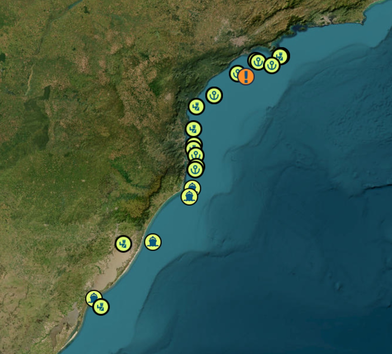
MARINAS
| Marina / Yacht Facility | Location | Services & Notes |
|---|---|---|
| Macapá Marina | Macapá, Amapá | Floating docks, water, electricity, basic provisioning—community-sourced info available on map apps like Navily :contentReference[oaicite:1]{index=1}. |
| São Luís Marina | São Luís, Maranhão | Facilities include electricity, water, showers, fuel, and Wi‑Fi—reviewed on Navily as a formal marina :contentReference[oaicite:2]{index=2}. |
| Marina Park Hotel | Fortaleza, Ceará | Modern hotel-marina with full berthing, fuel, haul-out, customs clearance, and marina services :contentReference[oaicite:3]{index=3}. |
| Porto do Mucuripe Yacht Access | Fortaleza Harbour, Ceará | Commercial port adjacent to Marina Park—yachts can berth and clear using charted lanes and support facilities :contentReference[oaicite:4]{index=4}. |
| Marina / Yacht Club | Location | Notes |
|---|---|---|
| Iate Clube do Natal | Natal (Rio Grande do Norte) | Port of entry; provides mooring buoys and basic facilities including water, showers, Wi‑Fi, and repair assistance :contentReference[oaicite:1]{index=1}. |
| Marina Park Hotel | Fortaleza (Ceará) | Modern hotel‑marina offering full‑service berths, haul‑out, fuel, and customs clearance. Reports advise caution due to dock condition :contentReference[oaicite:2]{index=2}. |
| Porto do Mucuripe Yacht Access | Fortaleza (Ceará) | Commercial port adjacent to Marina Park which supports yacht access and clearance lanes :contentReference[oaicite:3]{index=3}. |
| Recife Marina (Recife Marina) | Recife (Pernambuco) | Well-equipped marina with electricity, water, showers, fuel, sewage services, Wi‑Fi, and secure docking. High community ratings :contentReference[oaicite:4]{index=4}. |
| Pernambuco Iate Clube | Recife (Pernambuco) | Historic yacht club close to Recife Marina; tidal entrance—visibility and timing are important :contentReference[oaicite:5]{index=5}. |
| Recife Iate Clube | Recife (Pernambuco) | Another yacht club upstream; offers moorings and local facilities :contentReference[oaicite:6]{index=6}. |
| Cabanga Yacht Club | Recife (Pernambuco) | Yacht club with moorings; popular stop for transiting cruisers :contentReference[oaicite:7]{index=7}. |
| Bahia Marina | Salvador (Bahia) | Large marina with ~78 wet slips for vessels up to ~70 ft, offers water, power, laundry, showers, security, Wi‑Fi :contentReference[oaicite:8]{index=8}. |
| Marina Pier Salvador | Salvador (Bahia) | Part of the main marina complex; supports clearance, refuelling, and full services :contentReference[oaicite:9]{index=9}. |
| Terminal Náutico da Bahia | Salvador (Bahia) | Yacht facility within Bay of All Saints—anchoring options and access to urban services :contentReference[oaicite:10]{index=10}. |
| Marina / Yacht Club | Location | Notes |
|---|---|---|
| Marina Bracuhy | Angra dos Reis, Rio de Janeiro | Popular with cruisers; full services—fuel, power, showers, Wi‑Fi, haul‑out. One of the busiest marinas in the region :contentReference[oaicite:1]{index=1}. |
| Angra dos Reis Marina Clube (ARMC) | Angra dos Reis, Rio de Janeiro | Floating docks with water, electricity, showers, fuel, Wi‑Fi; highly rated by cruisers :contentReference[oaicite:2]{index=2}. |
| Marina Piratas | Ilha Grande / Angra dos Reis, Rio de Janeiro | Electricity, water, showers, fuel, Wi‑Fi; cruiser-reviewed; sheltered anchorage nearby :contentReference[oaicite:3]{index=3}. |
| Marina da Glória | Rio de Janeiro, Rio de Janeiro | Full‑service downtown marina under Sugarloaf; electricity, water, showers; no fuel :contentReference[oaicite:4]{index=4}. |
| Iate Clube do Rio de Janeiro (Urca) | Rio de Janeiro, Rio de Janeiro | Yacht club marina with moorings and club facilities; scenic location at Urca :contentReference[oaicite:5]{index=5}. |
| Marina da Barra | Barra da Tijuca, Rio de Janeiro | Large suburban marina with fuelling, maintenance, shops, restaurants :contentReference[oaicite:6]{index=6}. |
| Marina / Yacht Club | Location | Notes |
|---|---|---|
| Marina da Glória | Rio de Janeiro (RJ) | Downtown city marina near Sugarloaf; electricity, water, showers; no fuel available. :contentReference[oaicite:1]{index=1} |
| Brazilian Marina Yacht Club | Rio de Janeiro (RJ) | Dry parking, repair shops, haul‑out facilities, fuel, water, Wi‑Fi; good channel approach. :contentReference[oaicite:2]{index=2} |
| Florianópolis Yacht Club | Florianópolis (SC) | Multiple bays (Baía Norte, Lagoa da Conceição); haul‑out, service yards; vibrant sailing scene; top-rated facilities. :contentReference[oaicite:3]{index=3} |
| Marina Santo Antônio | Florianópolis (SC) | Well-reviewed by Navily users; covered spaces, security, water, electrical hookups. :contentReference[oaicite:4]{index=4} |
| Rio Grande Yacht Club | Rio Grande (RS) | Electricity, water, showers, fuel, Wi‑Fi; key entry/exit point for travel to Uruguay. :contentReference[oaicite:5]{index=5} |
| Paranaguá Marina | Paranaguá (PR) | Regional yacht access; adjacent to port; basic facilities for cruisers. :contentReference[oaicite:6]{index=6} |
PORTS OF ENTRY
A) North Coast
Oiapoque to Fortaleza
Oiapoque Amapá Remote land border; not recommended for yachts
Macapá Amapá Amazon delta entry; strong currents; basic services
Belém Pará Large river port; commercial; clearance possible
São LuísMaranhão Historic; strong currents; formalities available
Fortaleza Ceará Major entry port; Marina Park supports clearance
B) Northeast Coast
Fortaleza to Salvador
Natal Rio Grande do Norte Formal clearance possible; limited marina options
Recife Pernambuco Historic port; customs and immigration available
Maceió Alagoas Entry possible; limited facilities
Salvador Bahia Major port of entry with full services and marinas
C) Central Coast
Salvador to Rio
Ilhéus Bahia Smaller port; basic provisioning; check for availability
Vitória Espírito Santo Commercial port; entry formalities available
Cabo Frio Rio de Janeiro Possible entry; check locally for availability
Rio de Janeiro Rio de Janeiro Major port of entry; several marinas and full services
D) South Coast Rio to Uruguay Border
Santos São Paulo Largest commercial port; can be used for clearance
Paranaguá Paraná Commercial; entry available but limited yacht support
Florianópolis Santa Catarina Recognized port of entry; yacht club and services
Rio Grande Rio Grande do Sul Key entry/exit point for Uruguay; full clearance available
Porto Alegre Rio Grande do SulInland via Lagoa dos Patos; formalities available
Navigation & Safety Considerations
Brazilian coastal waters demand attentiveness and preparation. Although much of the coastline offers open-ocean sailing, local conditions—especially near ports, river mouths, reefs, and fishing areas—can present unique challenges.
Navigation Notes:
• Chart accuracy varies.
Major ports and tourist areas are well charted, but remote zones (especially the Amazon delta and southern estuaries) rely on old surveys. Use multiple sources: Navionics, paper charts, satellite imagery.
• GPS reliability:
Generally accurate, but signal drift is common near dense jungle, high rainfall areas, and deltas. Cross-reference with radar, depth soundings, and visual bearings.
• Magnetic variation:
Ranges from ~19°W in the north to ~21°W in the south. Account for this in traditional compass-based nav or paper plotting.
Entry & Exit Procedures:
• Brazil requires entry clearance at official ports that include:
◦ Macapá
◦ Fortaleza
◦ Salvador
◦ Rio de Janeiro
◦ Santos
◦ Rio Grande
• Clearance involves visiting:
◦ Polícia Federal (immigration)
◦ Receita Federal (customs)
◦ Capitania dos Portos (maritime authority)
• Documentation:
◦ Passports (with visa if required)
◦ Crew list
◦ Vessel registration/documentation
◦ International clearance from last port
◦ Health clearance (rarely enforced unless from specific ports)
Safety and Security:
• Petty theft is the primary concern—especially in urban ports.
◦ Lock dinghies and outboards.
◦ Don’t leave gear or laundry unattended.
◦ Use cable locks when anchoring off cities.
• Armed robbery is rare along the coast, but river piracy has been reported inland on the Amazon and tributaries.
• Boarding attempts at anchor are very uncommon but have occurred. Use motion sensors or dogs for peace of mind.
• VHF monitoring:
Channel 16 is monitored by Capitania dos Portos and local harbor authorities. Use it to hail marinas, arrange entries, or report emergencies.
Fuel and Provisioning:
• Diesel is widely available near cities, but not always dockside—jerry jugs may be needed.
• Marinas or fuel stations often work with motorbike couriers or taxis to bring fuel dockside.
• Groceries: Markets are frequent, fresh, and inexpensive.
◦ Look for local markets (feiras livres) for the best produce.
◦ Larger chains: Pão de Açúcar, Carrefour, Atacadão.
Anchoring Considerations:
• Bottoms vary:
◦ Mud in rivers and estuaries
◦ Sand along beaches
◦ Rock/coral near reefs and islands
• Holding is generally good with a plow or Rocna anchor and adequate scope (5:1 or more).
• Tidal range is modest in most of Brazil (1–2 meters), but can reach 4+ meters near the Amazon and in southern estuaries.
• Avoid anchoring near river mouths during rainy season.
◦ Runoff and flood tides can generate strong currents.
◦ Debris including trees and fishing nets can damage gear or foul props.
Local Hazards:
• Fishing gear: Longlines, floating nets, and drift buoys are common and often unlit at night.
• Debris: Rivers flush debris including logs, vegetation mats, and plastic waste—especially near deltas.
• Reefs: The Abrolhos area and parts of Bahia have coral heads—use waypoints and enter only in good light.
Aids to Navigation:
• Lighthouses and buoys exist but may be unlit, off-station, or missing—especially in rural areas.
• Major commercial ports (Recife, Salvador, Rio, Santos) maintain working channel markers.
• Avoid reliance on fishing boats or informal markers as indicators of safe water—they are often misleading or unrelated.
DOCUMENTS
MUST SEE
1) 🇧🇷 Top 10 Must-See Places – Northern Brazil Coast (Amapá to Maranhão)
1. Oiapoque River Estuary & Cabo Orange National Park
📍 3°50.400′ N 51°19.800′ W
• The northernmost tip of Brazil’s coastline.
• Pristine mangroves, jaguars, and manatees.
• One of the only national parks on Brazil’s coast north of the equator.
• Great for off-grid exploration by dinghy or kayak.
2. Macapá & the Equator Line Monument
📍 0°01.000′ N 51°03.000′ W
• The only Brazilian capital right on the equator.
• “Marco Zero” monument lets you stand in both hemispheres.
• Amazon River meets Atlantic here – very strong currents and tide.
• Good provisioning stop with local markets and repair services.
3. Amazon Delta Islands (Furo do Tajapuru / Ilha Mexiana)
📍 0°30.000′ S 50°45.000′ W
• Labyrinthine maze of rivers, islands, and floating villages.
• Real Amazon vibe with unique tidal bores and “pororoca” waves.
• Remote anchoring for advanced navigators.
4. Pará Mangrove Coastline (Reentrâncias Paraenses)
📍 1°30.000′ S 47°30.000′ W
• Massive mangrove estuaries and rare birdlife.
• One of the least inhabited and least charted areas.
• Caution: shallow shifting mudbanks – not for the faint of heart.
5. São João de Pirabas & Algodoal Island
📍 0°34.000′ S 47°31.000′ W
• Rustic fishing villages, windsurf culture, and mangrove eco-tourism.
• Sandy-bottom anchorage near Ilha de Maiandeua.
• Authentic Amazonian coastal life.
6. Belém (Gateway to the Amazon)
📍 1°27.000′ S 48°30.000′ W
• Historic riverport with colonial architecture and bustling river markets.
• Famous Ver-o-Peso Market – exotic fruits, fish, and crafts.
• Launchpad to the interior or a break before heading east.
7. Salinópolis Beach & Maçarico Boardwalk
📍 0°37.000′ S 47°21.000′ W
• Locals’ beach escape with wide tidal beaches and warm surf.
• Safe anchorage near the port.
• Excellent for provisioning and stretch-the-legs time.
8. Delta do Parnaíba
📍 2°45.000′ S 41°49.000′ W
• One of only a few oceanic deltas in the Americas.
• Shifting sandbars, freshwater dolphins, and mangrove tunnels.
• Great eco-tourism by canoe or panga.
• Anchor cautiously – entry requires timing and knowledge.
9. Lençóis Maranhenses National Park
📍 2°32.000′ S 43°07.000′ W
• Vast white dunes filled with freshwater lagoons.
• Stunning from the air and surreal on foot.
• Requires overland trip from Barreirinhas – not accessible by yacht but worth the trip inland.
10. São Luís – UNESCO World Heritage Site
📍 2°31.000′ S 44°18.000′ W
• Colonial Portuguese architecture with Afro-Brazilian flair.
• Live reggae and tambor de crioula music scene.
• Major port with provisioning, repairs, and marina potential (Porto do Itaqui nearby).
• Ideal gateway before turning south into more developed cruising zones.
b) 🇧🇷 Top 10 Must-See Places – Brazil’s Northeast Coast (São Luís to Recife)
1. Atins & the Eastern Edge of Lençóis Maranhenses
📍 2°43.000′ S 42°43.000′ W
• Quiet fishing village at the mouth of the Rio Preguiças.
• Wind and kitesurfing paradise.
• Access point to the dunes and lagoons by small boat.
• Unique anchoring among sandbanks.
2. Delta do Parnaíba
📍 2°45.000′ S 41°49.000′ W
• Must-see crossover point, also accessible from this section.
• Best visited from Camocim or Tutóia for easier access.
• Freshwater dolphins, exotic birdlife, and shifting island scenery.
3. Jericoacoara National Park
📍 2°47.000′ S 40°30.000′ W
• World-renowned kitesurf and windsurf hub.
• Iconic rock formations, sand dunes, and lagoons.
• Shore access tricky – best to anchor off Preá or Camocim and head in by land.
• Magical sunsets over the dunes.
4. Fortaleza – Big City Beach Culture
📍 3°43.000′ S 38°30.000′ W
• Largest urban stop on this stretch with marinas and repair yards.
• Great provisioning, nightlife, and fuel.
• Anchoring possible near Marina Park Hotel or Iate Clube de Fortaleza.
• Close to international airport.
5. Canoa Quebrada
📍 4°32.000′ S 37°41.000′ W
• Cliffside town famous for its crescent moon symbol carved into red cliffs.
• Laid-back and artsy atmosphere.
• Beachfront buggy tours and relaxed anchorages.
6. Galinhos Peninsula
📍 5°05.000′ S 36°16.000′ W
• Hidden gem of Brazil’s northeast.
• Accessible via tidal canal system.
• Long sandbars, mangroves, and total tranquility.
• Great place for a quiet rest and water-based exploration.
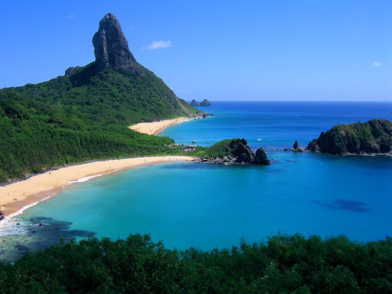
7. Fernando de Noronha (Optional Offshore Excursion)
📍 3°51.000′ S 32°25.000′ W
• 220 NM offshore from Natal.
• Protected UNESCO Marine Park with strict anchoring rules.
• Stunning underwater visibility, turtles, and spinner dolphins.
• Permit and fee required – advance planning essential.
8. Natal & Ponta Negra
📍 5°46.000′ S 35°12.000′ W
• Capital of Rio Grande do Norte.
• Notable for its long beaches and dunes.
• Safe harbor at Iate Clube do Natal or Rio Potengi.
• Nearby Genipabu dunes are worth a buggy trip.
9. João Pessoa & Praia do Jacaré
📍 7°03.000′ S 34°51.000′ W
• One of the easternmost points in the Americas.
• Praia do Jacaré: famous for saxophone sunset serenades on the river.
• Marina Jacaré Village is cruiser-friendly.
• Inland detour to colorful colonial João Pessoa.
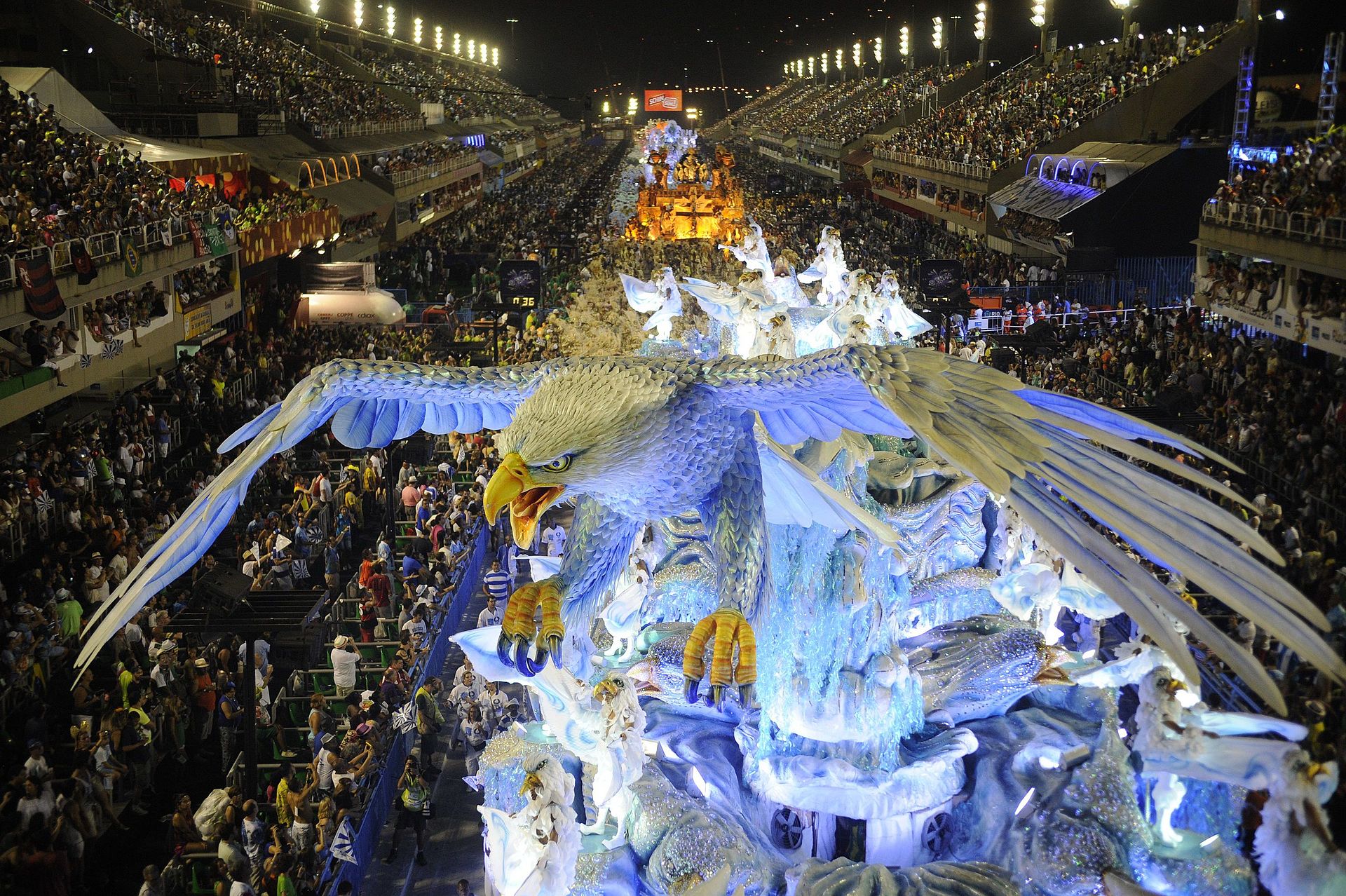
10. Recife & Olinda – Culture and Carnival Capital
📍 8°03.000′ S 34°52.000′ W
• Major cruising hub with marina facilities at Cabanga Iate Clube.
• Explore Recife Antigo and the Venice-like canals.
• Historic Olinda: UNESCO World Heritage, with colonial churches and carnival culture.
• Good provisioning and airport access.
C) 🇧🇷 Top 10 Must-See Places – Brazil CENTRAL Coast (Recife to Cabo Frio)
1. Porto de Galinhas & Muro Alto Reef Pools
📍 8°30.000′ S 35°00.000′ W
• Colorful beach town just south of Recife.
• Famous for natural tidal pools with crystal-clear water.
• Limited anchorage options, but excellent for a day visit by land or tender.
2. Maceió & Praia do Francês
📍 9°39.000′ S 35°42.000′ W
• Capital of Alagoas with decent marina infrastructure.
• Nearby Praia do Francês is a windsurfing and beach hotspot.
• Good place for refueling, provisions, and inland exploration.
3. Manguaba & Mundaú Lagoons
📍 9°45.000′ S 35°52.000′ W
• A unique mix of river, lagoon, and mangrove systems.
• Local wooden sailboats (jangadas) and peaceful anchorages.
• Excellent birdwatching and dinghy exploring.
4. Aracaju & São Cristóvão (Sergipe River)
📍 10°55.000′ S 37°03.000′ W
• Lesser-visited but charming capital of Sergipe.
• Access the colonial town of São Cristóvão upriver.
• Anchorage on the river is safe and scenic with mangrove backdrop.
5. Salvador da Bahia – Cultural Heartbeat of Brazil
📍 12°58.000′ S 38°30.000′ W
• One of the best cities for sailors on Brazil’s coast.
• Two major marinas: Marina Bahia and Terminal Náutico.
• Explore the Pelourinho, Candomblé culture, music, and colonial forts.
• Excellent provisioning and service facilities.
6. Baía de Todos os Santos (All Saints Bay)
📍 13°00.000′ S 38°30.000′ W
• Brazil’s largest natural bay.
• Dozens of protected anchorages, charming islands like Itaparica and Frades.
• Perfect for sailing exploration in protected waters.
• Accessible year-round with strong cultural offerings.
7. Morro de São Paulo & Tinharé Archipelago
📍 13°23.000′ S 38°55.000′ W
• Laid-back beach town with no cars, famous for its party vibe and sand paths.
• Anchor off Gamboa or use mooring buoys.
• Great hiking and seafood.
• Ferry access to Salvador makes this a popular stop.
8. Ilhéus & Cocoa Coast
📍 14°47.000′ S 39°02.000′ W
• Anchor near the city for access to culture and provisioning.
• Rich history of cocoa production (the setting for Jorge Amado’s novels).
• Inland waterfalls, cacao farms, and rustic Atlantic Rainforest hikes.
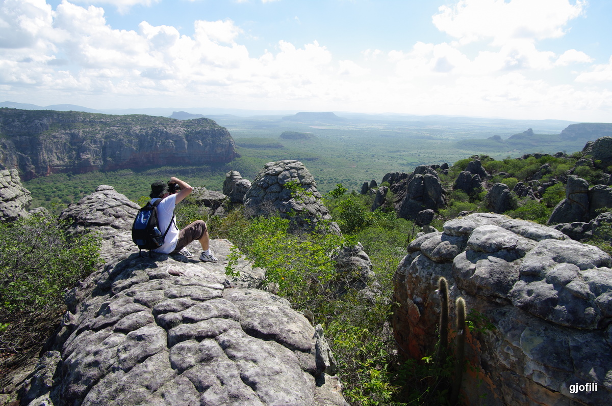
9. Abrolhos Archipelago – Marine Park & Coral Reefs
📍 17°57.000′ S 38°41.000′ W
• Offshore archipelago with Brazil’s best coral reefs.
• Dive with humpback whales (in season: July – November).
• Permit and advance coordination required for anchoring or diving.
• Uninhabited islands with ranger stations.
10. Vitória – Capital of Espírito Santo
📍 20°18.000′ S 40°20.000′ W
• Well-developed port city with a modern vibe.
• Yacht Club of Vitória offers secure anchorage.
• Good spot to resupply, haul out, or rest.
• Cultural sights, seafood, and inland mountains (Pedra Azul).
D) 🇧🇷 Top 10 Must-See Places – Brazil’s Southern Coast ( Vitória to Chuí )
1. Ilha Grande & Abraão Bay
📍 23°08.000′ S 44°09.000′ W
• Premier cruising ground in Brazil.
• Dozens of protected bays, beaches, and rainforest trails.
• No cars, pristine anchorages, hiking, waterfalls, and snorkeling.
• Sailors’ favorite – safe, scenic, and well-charted.
2. Paraty – Colonial Gem
📍 23°13.000′ S 44°43.000′ W
• UNESCO World Heritage Site with 17th-century architecture.
• Charming cobblestone streets, music festivals, and historic churches.
• Secure anchorage and access to marina services.
• Good provisioning and culture with laid-back nautical flair.
3. Angra dos Reis – Yacht Service Hub
📍 23°00.000′ S 44°19.000′ W
• Region of 365 islands and full marina infrastructure.
• Excellent for refits, haul-outs, and parts.
• Numerous anchorages and proximity to Ilha Grande.
• Marina Bracuhy and Marina Verolme are key stops.
4. Rio de Janeiro – Iconic Coastal City
📍 22°54.000′ S 43°10.000′ W
• Cruise beneath Sugarloaf and Christ the Redeemer.
• Anchor inside Guanabara Bay or stay at Marina da Glória.
• Intense culture, music, and historical sites.
• Watch for harbor traffic and shifting winds.
5. Ilhabela – Surf, Hiking, and Waterfalls
📍 23°46.000′ S 45°21.000′ W
• Brazil’s top sailing destination after Ilha Grande.
• Lush mountainous island with excellent anchorages and trails.
• Channel currents can be strong – plan entry carefully.
• Host to Brazil’s most prestigious sailing regattas.
6. Santos – Brazil’s Busiest Port
📍 23°57.000′ S 46°20.000′ W
• Historic coffee export center with colonial districts.
• Marina access at Guarujá across the channel.
• Major provisioning port with haul-out capacity.
• Useful stopover for urban needs, but busy and industrial.
7. Cananéia & Lagamar Estuary
📍 25°00.000′ S 47°55.000′ W
• Remote-feeling mangrove estuary and colonial village.
• Safe river anchorages and dolphin-filled waters.
• Near the São Paulo-Paraná ecological corridor.
• Great for nature and birdwatching from the cockpit.
8. Florianópolis (Santa Catarina Island)
📍 27°35.000′ S 48°32.000′ W
• Excellent infrastructure for yachts at Iate Clube de Santa Catarina.
• Mix of surf beaches, nightlife, seafood, and sailing.
• Lagoa da Conceição and Praia Mole are iconic nearby.
• Reliable haul-out options and boatyards.
9. Ilha do Mel – Surf & Simplicity
📍 25°30.000′ S 48°19.000′ W
• Protected island off the Paraná coast with no roads.
• Great hiking, beaches, and anchorages.
• Close to Paranaguá, Brazil’s oldest port city.
• Anchor near the lighthouse or Encantadas village.
10. Rio Grande & Lagoa dos Patos
📍 32°01.000′ S 52°05.000′ W
• Southernmost major port before reaching Uruguay.
• Access point to inland lagoon system and wildlife reserves.
• Cold fronts from the south can be intense – plan carefully.
• Marina and customs clearance available at Porto do Rio Grande.
🛠️ Highlights
-
Top 3 full-service centers: Angra dos Reis, Itajaí, Salvador
-
Good international clearance hubs: Fortaleza, Salvador, Rio Grande
-
Best for refit projects: Itajaí, Angra dos Reis, Santos
🇧🇷 Major Yacht Service Centers in Brazil (North to South)
| Location | Region | Key Facilities & Notes |
|---|---|---|
| Fortaleza (Ceará) | Northeast | ✔ Marina Park Hotel offers haul-out ✔ Fuel dock, customs clearance ✔ Engine and rigging technicians available ✔ Good provisioning in city |
| Natal (Rio Grande do Norte) | Northeast | ✔ Iate Clube do Natal offers moorings ✔ Basic haul-out and repair support via local yards ✔ Used as an entry port for northbound yachts |
| Recife (Pernambuco) | Northeast | ✔ Recife Marina and Cabanga Iate Clube ✔ Travel lifts, sail repair, mechanical service ✔ Electronics, welding, woodworking nearby |
| Salvador (Bahia) | Northeast | ✔ Bahia Marina: full-service with chandlery, fuel, riggers, mechanical and electronics repair ✔ Customs and immigration nearby ✔ Excellent provisioning and security |
| Ilhéus / Itacaré (Bahia) | Northeast | ✔ Emerging cruiser stop ✔ Limited yard services; better for provisioning, rest |
| Vitória (Espírito Santo) | Central-East | ✔ Some small yards for hull cleaning and repairs ✔ Not widely used by international yachts but decent facilities for locals |
| Angra dos Reis (Rio de Janeiro) | Central | ⭐ One of Brazil’s most important yacht hubs ✔ Bracuhy Marina, Marina Verolme, Marina Piratas ✔ Full haul-out, dry storage, welding, fiberglass, engines, rigging, sailmakers, etc. ✔ Strong local supply chain |
| Paraty (Rio de Janeiro) | Central | ✔ Protected anchorage, smaller yards and marine mechanics ✔ Sail repair and engine tech available ✔ Ideal for minor work and provisioning |
| Rio de Janeiro (City) | Central | ✔ Marina da Glória and Urca area ✔ Mechanical, rigging, haul-out in nearby Niterói ✔ Fuel, chandlery, provisioning ✔ Ideal for in-transit repairs |
| Ilhabela (São Paulo) | Southeast | ✔ Yacht club with access to services ✔ Dry dock options on mainland side (São Sebastião) ✔ Electronics, rigging, and sail repair available |
| Santos / Guarujá (São Paulo) | Southeast | ✔ Multiple marinas and boatyards ✔ Fiberglass, hull work, engines, stainless fabrication ✔ Big port city, excellent supply chain |
| Florianópolis (Santa Catarina) | South | ✔ Full service at Iate Clube de Santa Catarina ✔ Haul-out, engine and hull repair ✔ Sailmakers and marine electronics ✔ Reliable contractors, skilled workforce |
| Itajaí (Santa Catarina) | South | ⭐ Site of the Volvo Ocean Race stopover ✔ Professional-grade refit yards (e.g., Marina Itajaí) ✔ World-class facilities, large capacity ✔ Customs and port formalities handled onsite |
| Rio Grande (Rio Grande do Sul) | South | ✔ Final port before Uruguay ✔ Rio Grande Yacht Club ✔ Engine and rigging services ✔ Good haul-out and maintenance options, especially for smaller vessels |
REPAIRS AND SERVICE PROVIDERS
EMERGENCIES AND SAR INFO
BRAZIL / BRASIL EMERGENCY PHONE NUMBERS DIAL FROM TELEPHONE OR CELL PHONE
- Military Police (Polícia Militar): 190
- Public Hospital Ambulance (SAMU): 192
- Fire Department (Corpo de Bombeiros): 193
- Humans Rights (Direitos Humanos): 100
- Women’s Services (Defesa à Mulher): 180
- Anonymous Reports (Disque Denúncia): 181
- Civil Defense (Defesa Civil): 199.
WEATHER
Brazil’s coast spans equatorial to temperate zones, and understanding regional weather and current patterns is critical for safe passage planning. The seasons shift gradually from north to south, with significant variation in wind direction, rainfall, swell, and navigational conditions.
🧭 General Seasonal Overview
🌬️ Wind Patterns
North Coast: Influenced by the Intertropical Convergence Zone (ITCZ). Expect light to moderate NE trade winds, often interrupted by calms or squalls during the rainy season (Jan–May).
Northeast Coast: Stronger SE trades dominate from June to November. Good sailing conditions but sometimes choppy with strong fetch.
Central Coast: More variable winds, with SE trades interrupted by cold fronts from the south (called frentes frias).
South Coast: Winds become more cyclonic and frontal, with southwest squalls, north winds ahead of fronts, and SE winds in their wake. Gales can form quickly, especially between São Paulo and Rio Grande do Sul.
| Region | Best Cruising Season | Prevailing Winds | Rainy Season | Sea Conditions |
|---|
| Equator to Fortaleza | August – December | E-NE Trades | Jan – May | Hot, humid, rain squalls in wet season |
| Fortaleza – Salvador | July – November | E-SE Trades | Mar – July | Consistent winds, stronger trades in dry season |
| Salvador – Rio | June – October | E-SE, with frontal passages | Mar – July | More variable; influence of South Atlantic High |
| Rio – Uruguay | November – March | SW-NW variable | May – Sept | Cold fronts, stronger swell, storm risk in winter |
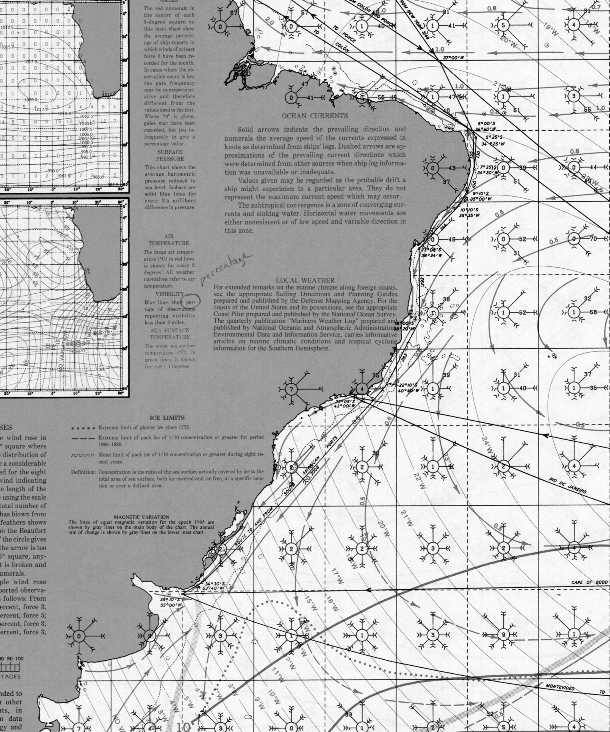
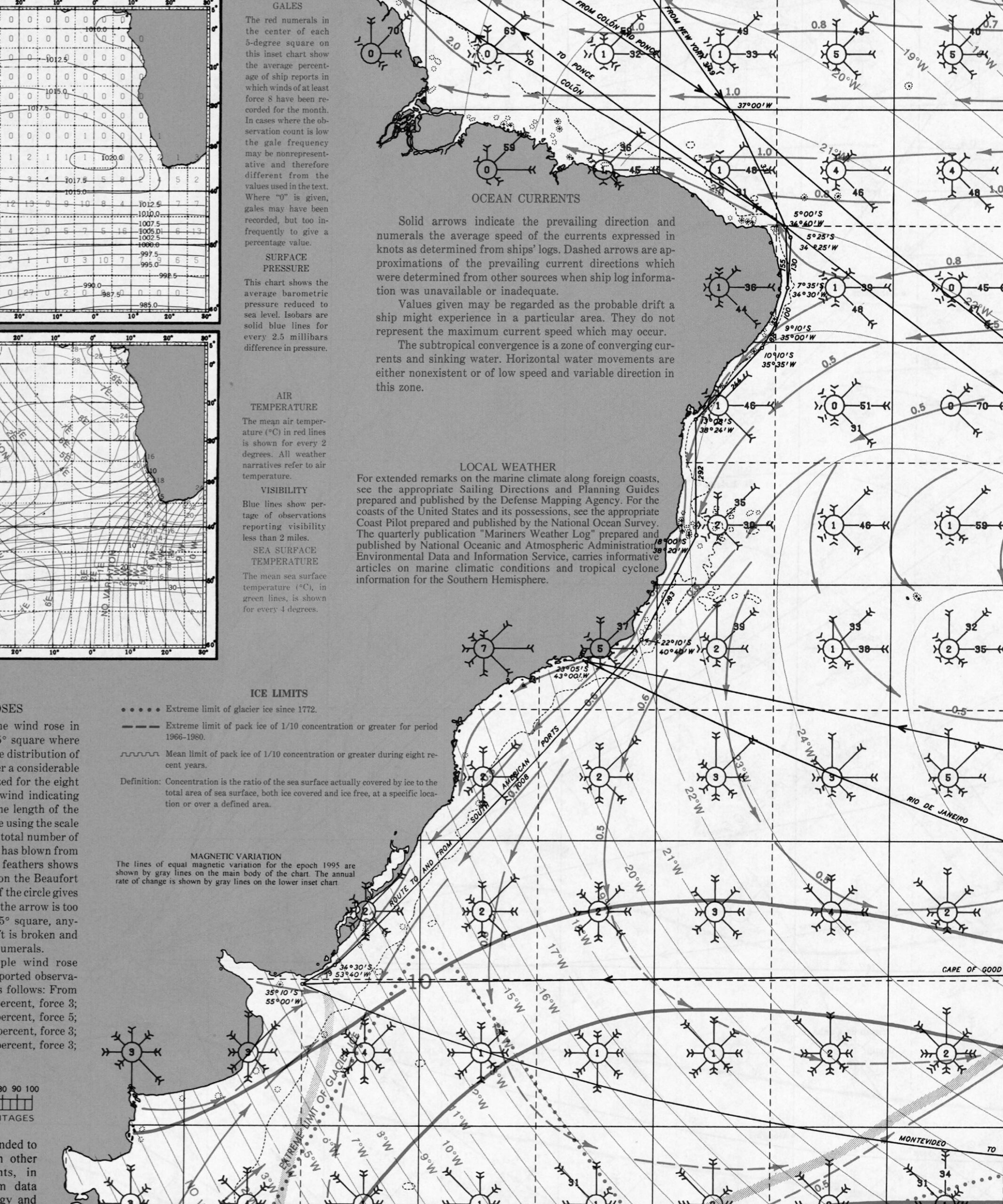
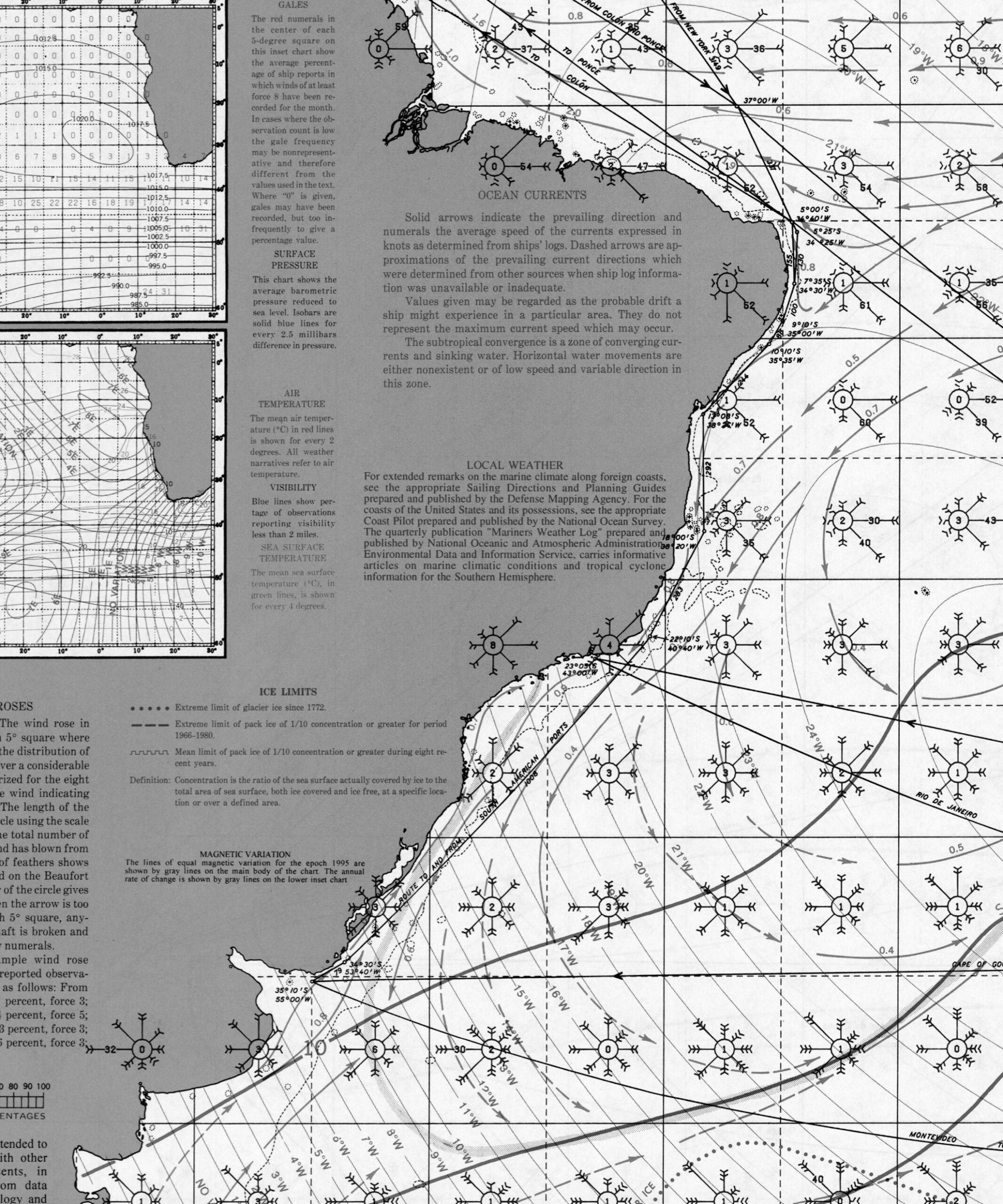
🌊 Currents
• The entire Brazilian coast is influenced by the South Equatorial Current, which splits near the northeast tip:
◦ North Brazil Current: Flows northwest into the Caribbean.
◦ Brazil Current: Flows southwest, hugging the coast all the way to Rio Grande do Sul.
Average surface speeds:
• North & Northeast Coast: 0.5 to 1.5 knots (southward)
• Central Coast: 0.3 to 1.0 knots (southward)
• South Coast: 0.2 to 0.8 knots (variable with wind reversal during fronts)
Note: Counter-currents and eddies near major capes (Cabo de São Tomé, Cabo Frio) can affect speed and sea state.
🌧️ Rainfall & Thunderstorms
• The north and northeast see heavy rain and thunderstorms in summer months (Dec–Apr).
• Salvador to Rio experiences brief, localized squalls with frontal systems.
• The south sees more stable weather in austral summer (Nov–Mar), with cold fronts and heavy rain more frequent from May to September.
🌀 Tropical Storm Risk
• Brazil lies outside the main hurricane belt.
• However, subtropical cyclones do occasionally form south of 25°S (especially off the coast of Santa Catarina and Rio Grande do Sul). These can cause gale-force winds, high seas, and should be tracked during austral summer.
WIND
-4.652698585714306, 104987154
SWELL
BRAZIL PILOT CHARTS
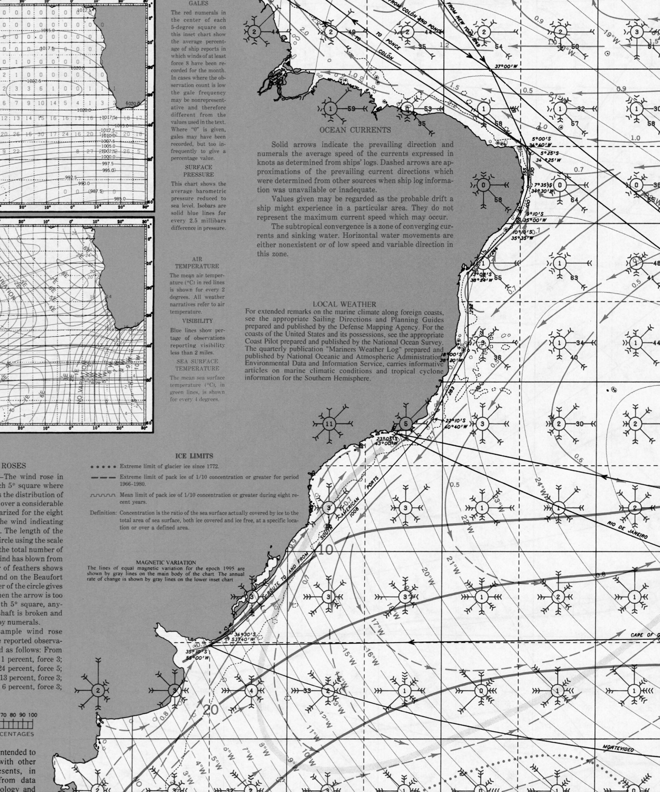
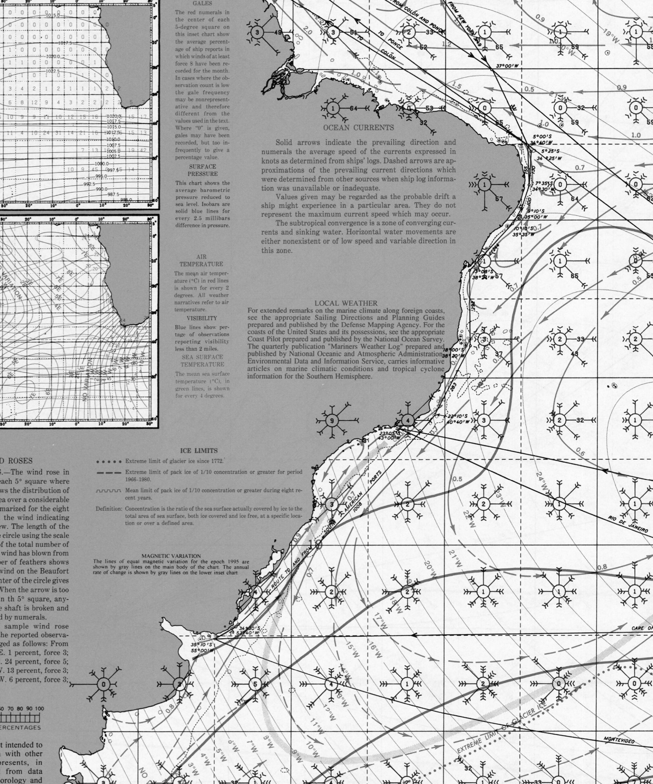
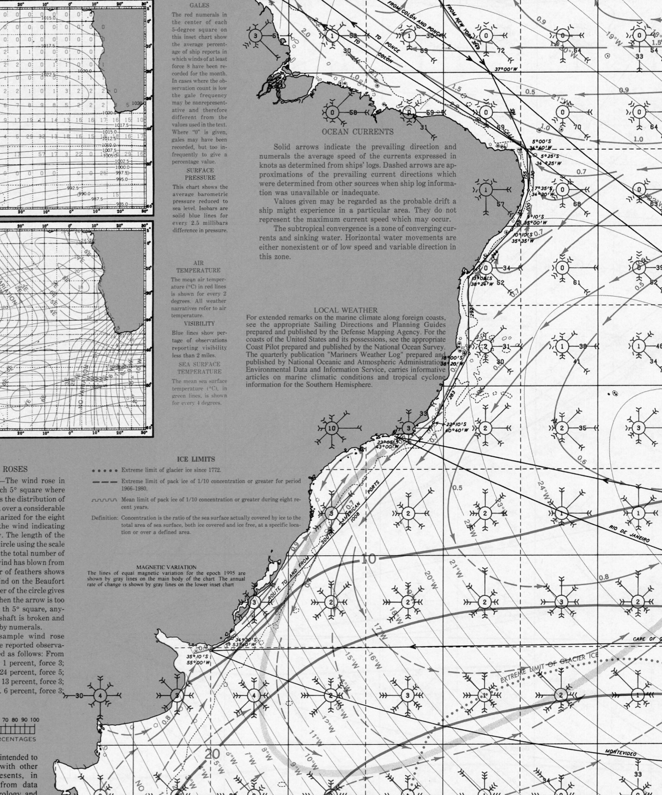
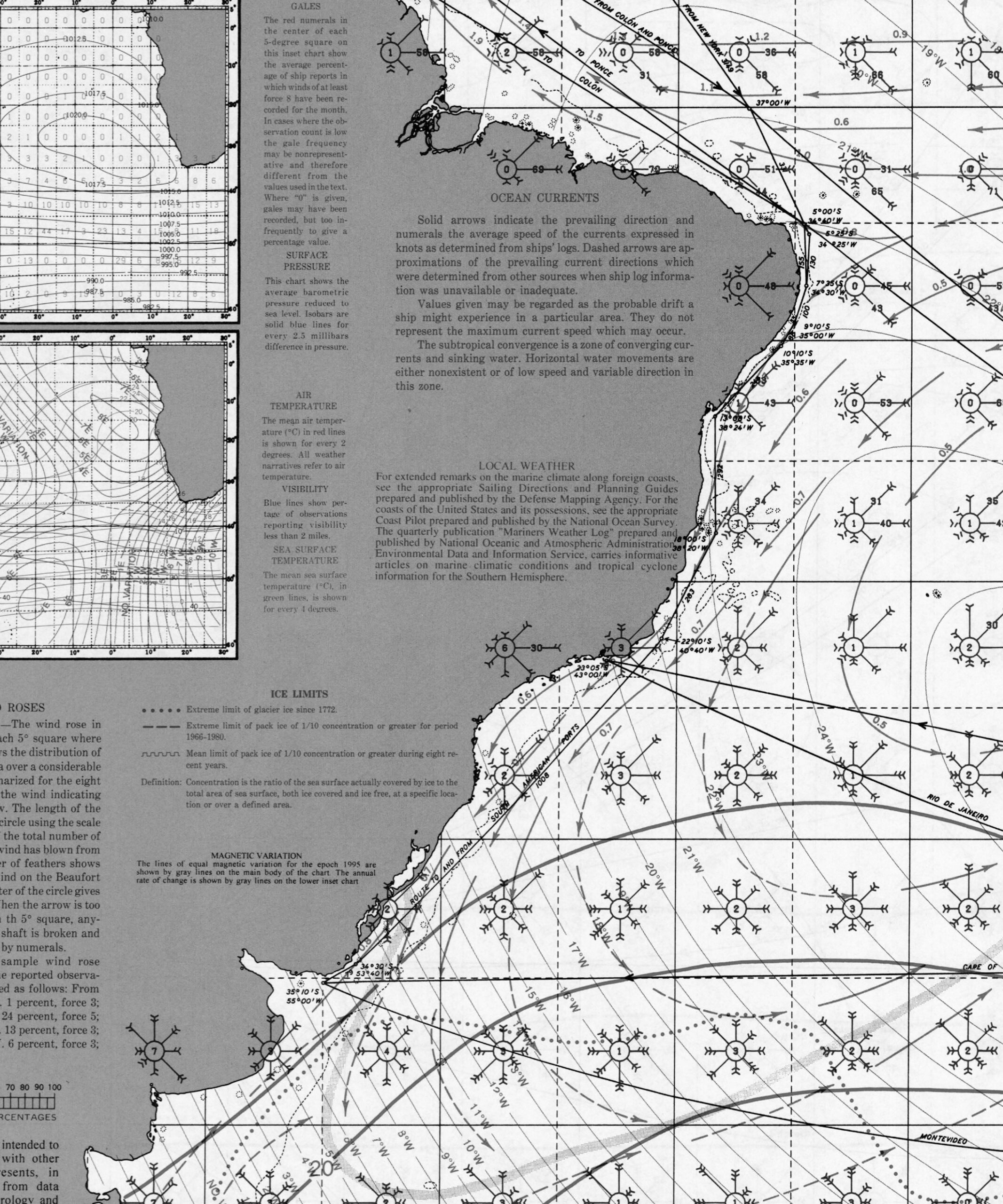
Brazil Pilot Charts provide historic points and aggregated information of wind flows, air and ocean temperatures, wave heights, rain, barometric weight, and climate conditions at various seasons. This data was acquired from oceanographic and meteorologic perceptions over hundreds of years starting in the late eighteenth century. These diagrams are planned to help mariners choose routes around and approaching Brazil with respect to the normal climate and sea conditions using prevailing seasonal wind information.


CHARTS
Charts, Cruising Guides & Local Info
Accurate navigation along the Brazilian coast requires multiple charting tools, up-to-date weather sources, and local intelligence. While Brazil’s hydrographic authority provides broad coverage, gaps remain—especially near river mouths, remote estuaries, and less-traveled regions.
Charts & Digital Navigation Tools:
• DHN (Diretoria de Hidrografia e Navegação):
◦ Brazil’s official hydrographic office.
◦ Offers free raster charts, though some are outdated.
◦ Download via the DHN website—Portuguese only.
◦ Datum is sometimes SAD69—confirm and match in your plotter.
• Navionics:
◦ Generally accurate along populated coastline and near major ports.
◦ Coverage gets patchy in deltas, Amazon basin, and southern estuaries.
◦ Still the most widely used digital charting platform in Brazil.
• NV Charts (Germany):
◦ High-quality paper/digital chart packs available for the southeast and south coast.
◦ Good choice for sailors heading to/from Uruguay or the South Atlantic crossing.
• OpenCPN:
◦ Excellent open-source tool for route planning and navigation.
◦ Compatible with DHN raster charts, satellite overlays, and GPX tracks.
◦ Use with plugins like Weatherfax, AIS, and Climatology for advanced use.
Cruising Apps & Resources:
• Aquamaps:
◦ Good for general planning and route building.
◦ Some missing detail for Brazil’s inner waterways and lagoons.
• Navily:◦ Gaining popularity; limited Brazil entries so far.
• NFL:◦ Gaining popularity;
◦ Community reviews helpful where available.
• MarineTraffic / VesselFinder:
◦ Monitor AIS traffic, port congestion, and large vessel movements.
• PredictWind / Windy / Windguru:
◦ Essential for planning passages, monitoring fronts, and watching wind shifts.
◦ Brazil’s long coast means forecasts vary by zone—check multiple models.
Cruising Guides:
• No single comprehensive Brazil cruising guide exists in English. Instead, use a combination of the following:
◦ Noonsite (noonsite.com): Updated info on formalities, ports of entry, safety, and local contacts.
◦ Cruisers’ blogs (in English, Portuguese, or Spanish)—many updated by sailors currently exploring Brazil.
◦ YouTube cruising channels like “Sailing Uma” and “Sailing Paraty” provide visual insight.
Local Knowledge & Communities:
• WhatsApp groups:
◦ Common among Brazilian and foreign sailors.
◦ Ask marinas or fellow cruisers for links to regional chat groups (e.g., Salvador, Paraty, Ilha Grande).
• Capitania dos Portos:
◦ Present in each state—responsible for vessel inspections and maritime rules.
◦ Useful for confirming rules, registering arrivals, and reporting issues.
◦ Portuguese only, but generally helpful and professional.
• VHF Usage:
◦ Monitored in commercial ports.
◦ Marinas respond on VHF 16 and sometimes on 68 or 71 (confirm locally).
• Marinha do Brasil app:
◦ Offers official bulletins, marine weather alerts, and zone closures.
◦ Best used in Portuguese; can alert to sudden changes in weather or maritime restrictions.
Additional Resources:
• Good Nautical:
◦ Offers GPX files, anchorage guides, and real-time fleet tracking (for Ocean Posse participants).
◦ Growing number of user-submitted anchorages along Brazil’s coast.
• Satellite Imagery:
◦ Download offline tiles via SAS Planet or OvitalMap to help spot shoals, reef edges, and shallow entries.
◦ Invaluable when navigating near uncharted or shifting features.