

SAILING & Cruising in Curaçao
Curaçao, nestled in the southern Caribbean, offers a paradise for cruising enthusiasts with its idyllic climate, vibrant culture, and stunning landscapes. This Dutch Caribbean island, part of the ABC islands (Aruba, Bonaire, and Curaçao), is renowned for its crystal-clear waters, diverse marine life, and historical charm. Cruising around Curaçao provides a unique opportunity to explore pristine beaches, hidden coves, and the vibrant city life of Willemstad. Here’s an in-depth guide to help you navigate and make the most of your cruising adventure in Curaçao.
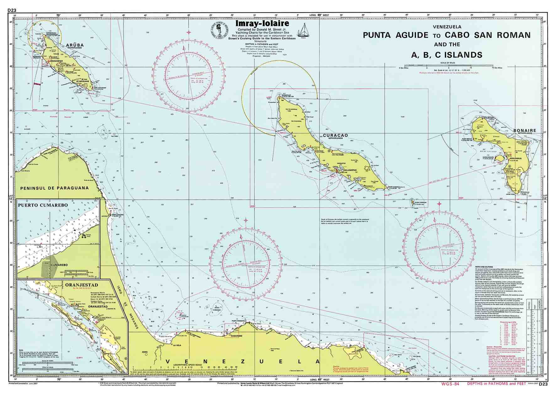
Ports of Entry
Port of Willemstad The main port of entry is located in Willemstad, the capital city. This deep-water harbor is well-equipped to handle yachts of all sizes. Upon arrival, captains must present valid papers at the harbor office and register all passengers at the Immigration Office. Willemstad’s port offers a blend of modern facilities and historical ambiance, making it a perfect starting point for your journey.
Curaçao Marine Situated near Willemstad, Curaçao Marine is another key port of entry. This marina is equipped with a large boatyard and various maintenance services. It’s a popular choice for yachts needing repairs or extended stays. The marina is also close to the vibrant city center, providing easy access to amenities and attractions.
Spanish Water Though not an official port of entry, Spanish Water is a favored anchorage spot due to its sheltered environment. It’s a perfect location to drop anchor and enjoy the tranquil waters while preparing for your formal entry procedures at Willemstad or Curaçao Marine.
Navigating Curaçao
Curaçao’s coastline is dotted with numerous bays and coves, offering excellent anchorages and marinas. Here are some key spots to consider:
Spanish Water Coordinates: 12°05.1’N, 68°51.0’W Spanish Water is one of the most popular anchorages on the island. This large, protected bay offers a safe haven for yachts and is surrounded by picturesque landscapes. It’s an excellent base for exploring the island, with nearby marinas providing all necessary facilities.
Seru Boca Marina Coordinates: 12°05.1’N, 68°51.0’W Located in a quiet corner of Spanish Water, Seru Boca Marina offers a peaceful and secure docking environment. This marina is ideal for those looking to leave their boat for an extended period or simply enjoy a tranquil stay. It lacks extensive facilities, but its serene setting makes it a popular choice.
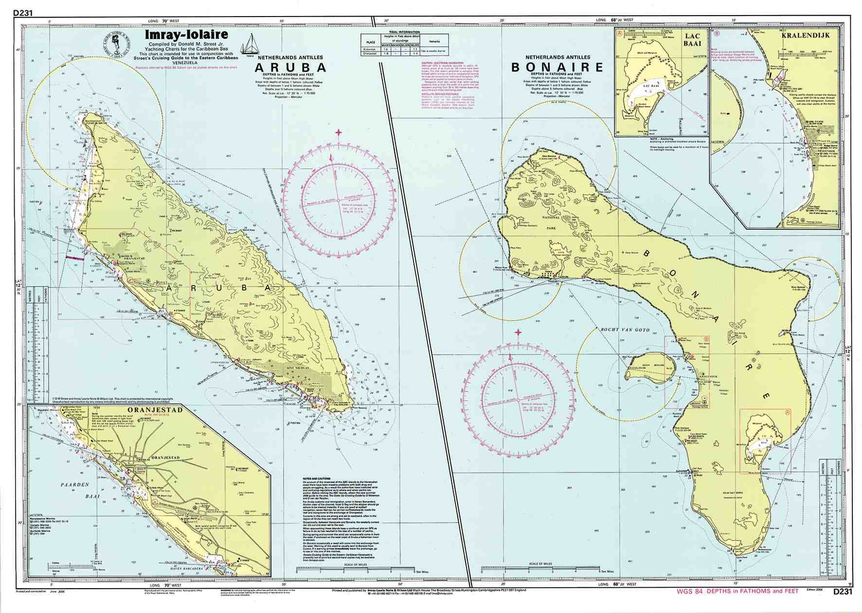
Klein Curaçao Coordinates: 11°59.5’N, 68°38.0’W A small, uninhabited island southeast of Curaçao, Klein Curaçao is a must-visit for its pristine beaches and excellent snorkeling and diving opportunities. The island’s clear waters and vibrant marine life make it a paradise for underwater enthusiasts.
Must-See Destinations
Willemstad Coordinates: 12°06.4’N, 68°56.0’W The capital city, Willemstad, is a UNESCO World Heritage site known for its colorful Dutch colonial architecture. The city is divided into Punda and Otrobanda by the Queen Emma Bridge, a floating pedestrian bridge. Punda is famous for its vibrant shopping district and the floating market, while Otrobanda offers a more residential feel with local eateries and historic buildings.
Christoffel National Park Coordinates: 12°20.0’N, 69°04.0’W This national park is home to Mount Christoffel, the highest point on the island. The park offers several hiking trails with varying levels of difficulty, leading to breathtaking views and diverse wildlife. It’s a perfect destination for nature lovers and adventure seekers.
Shete Boka National Park Coordinates: 12°22.0’N, 69°09.0’W Known for its rugged coastline and sea caves, Shete Boka National Park is a fantastic place to witness the power of the ocean. The park features several “bokas” (inlets), where waves crash dramatically against the rocks. Boka Tabla and Boka Pistol are particularly popular spots.
Hato Caves Coordinates: 12°11.6’N, 68°57.2’W These limestone caves, located near the airport, offer guided tours showcasing impressive stalactites, stalagmites, and ancient petroglyphs. The caves provide a fascinating glimpse into the island’s geological history.
Playa Kenepa Grandi (Grote Knip) Coordinates: 12°21.3’N, 69°09.4’W One of the most beautiful beaches on the island, Playa Kenepa Grandi is known for its clear turquoise waters and stunning scenery. It’s a favorite spot for swimming, snorkeling, and simply soaking up the sun.
Marine Life and Activities
Curaçao’s surrounding waters are teeming with marine life, making it a prime destination for snorkeling and diving. The island’s reefs are home to a variety of colorful fish, corals, and other marine creatures.
Snorkeling and Diving Spots
- Tugboat Wreck: Located near Caracas Bay, this site features a sunken tugboat teeming with marine life.
- Mushroom Forest: Known for its unique mushroom-shaped coral formations, this dive site is a favorite among divers.
- Klein Curaçao: Offers some of the best snorkeling and diving experiences with its clear waters and abundant marine life.
Safety and Regulations
When cruising in Curaçao, it’s important to adhere to local regulations and safety guidelines. Here are some key points to consider:
- Cruising Permits: Ensure you have the necessary cruising permits and documentation. While the coast guard patrols regularly, they may not always check permits, but it’s best to be prepared.
- Anchorages: Be mindful of designated anchorage spots and respect the local marine environment.
- Weather: Curaçao is outside the hurricane belt, making it a safe destination during hurricane season. However, always check weather forecasts and sea conditions before setting sail.
Local Culture and Cuisine
Curaçao’s culture is a vibrant mix of influences from its African, European, and Latin American heritage. The island’s official languages are Dutch, Papiamentu, and English, reflecting its diverse population.
Local Cuisine
- Keshi Yena: A traditional dish made with cheese stuffed with meat or seafood.
- Funchi and Tutu: Cornmeal-based side dishes often served with stews.
- Seafood: Fresh fish, conch, and lobster are commonly featured in local dishes.
Festivals and Events
- Carnival: Held in February or March, this vibrant festival features parades, music, and dancing.
- Seú Harvest Festival: Celebrated in April, this festival includes traditional dances, music, and food.
Practical Tips
- Currency: The official currency is the Netherlands Antillean guilder (ANG), but US dollars are widely accepted.
- Transportation: Renting a car is recommended for exploring the island, as public transportation is limited.
- Health and Safety: Drink bottled water and use sunscreen to protect against the strong Caribbean sun.
Conclusion
Cruising around Curaçao offers a unique blend of adventure, relaxation, and cultural exploration. From its pristine beaches and vibrant marine life to the historical charm of Willemstad and the natural beauty of its national parks, Curaçao has something to offer every sailor. By planning your trip carefully and respecting local regulations, you can ensure a safe and memorable cruising experience in this Caribbean paradise.
MARINAS
- Seru Boca Marina
- Location: Spanish Water, Curaçao
- Coordinates: 12°05.1’N, 68°51.0’W
- Details: This marina is ideal for those looking for a quiet and secure place to dock. It is known for its peaceful setting but lacks extensive facilities.
- Curaçao Marine
- Location: Near Willemstad, Curaçao
- Coordinates: 12°06.5’N, 68°55.0’W
- Details: This marina offers a large boatyard and various maintenance services, making it a common choice for yachts needing work or extended stays.
- Kima Kalki Marina
- Location: Spanish Water, Curaçao
- Coordinates: 12°04.8’N, 68°51.5’W
- Details: A small, private marina that accommodates yachts up to 60 feet. It offers a secure docking environment with necessary amenities such as electricity and water connections.
- Royal Marine (Piscadera Bay)
- Location: Piscadera Bay, Curaçao
- Coordinates: 12°07.3’N, 68°58.4’W
- Details: This marina provides basic docking services, though it may not be recommended due to mixed reviews regarding its facilities and management.
- Caracasbaai Marina
- Location: Caracas Bay, Curaçao
- Coordinates: 12°04.5’N, 68°52.0’W
- Details: Offers a range of facilities including docking, fuel, and water, and is situated in a bay known for its clear waters and popular snorkeling spots.
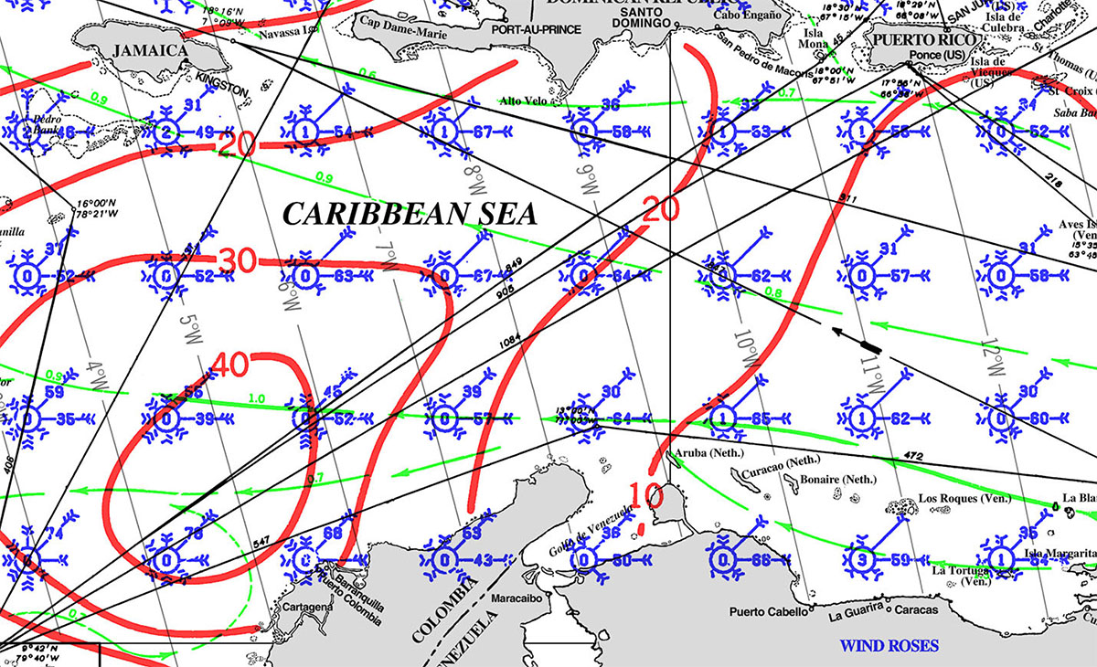
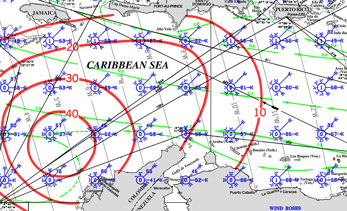
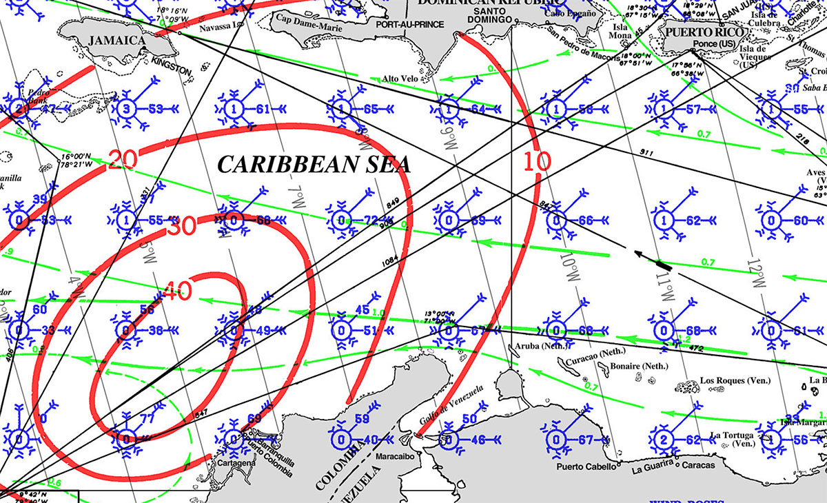
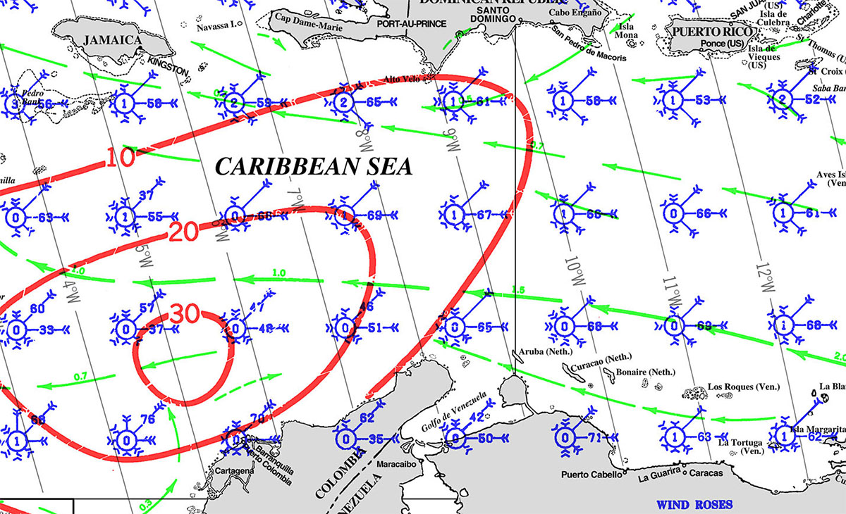
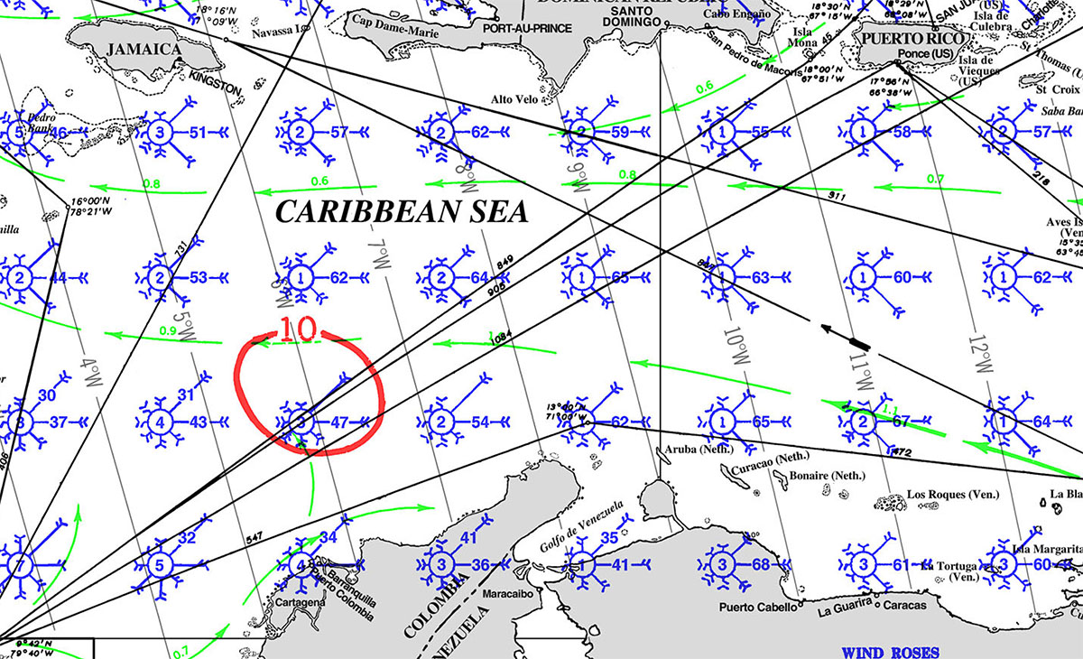
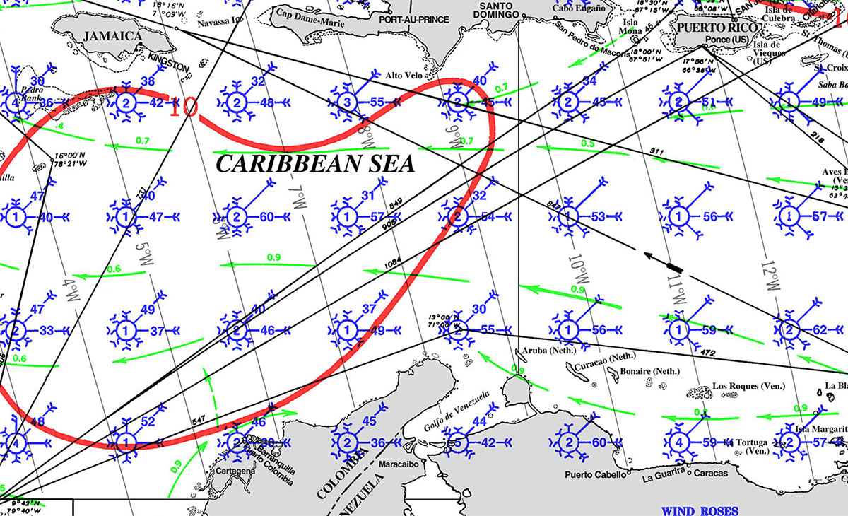
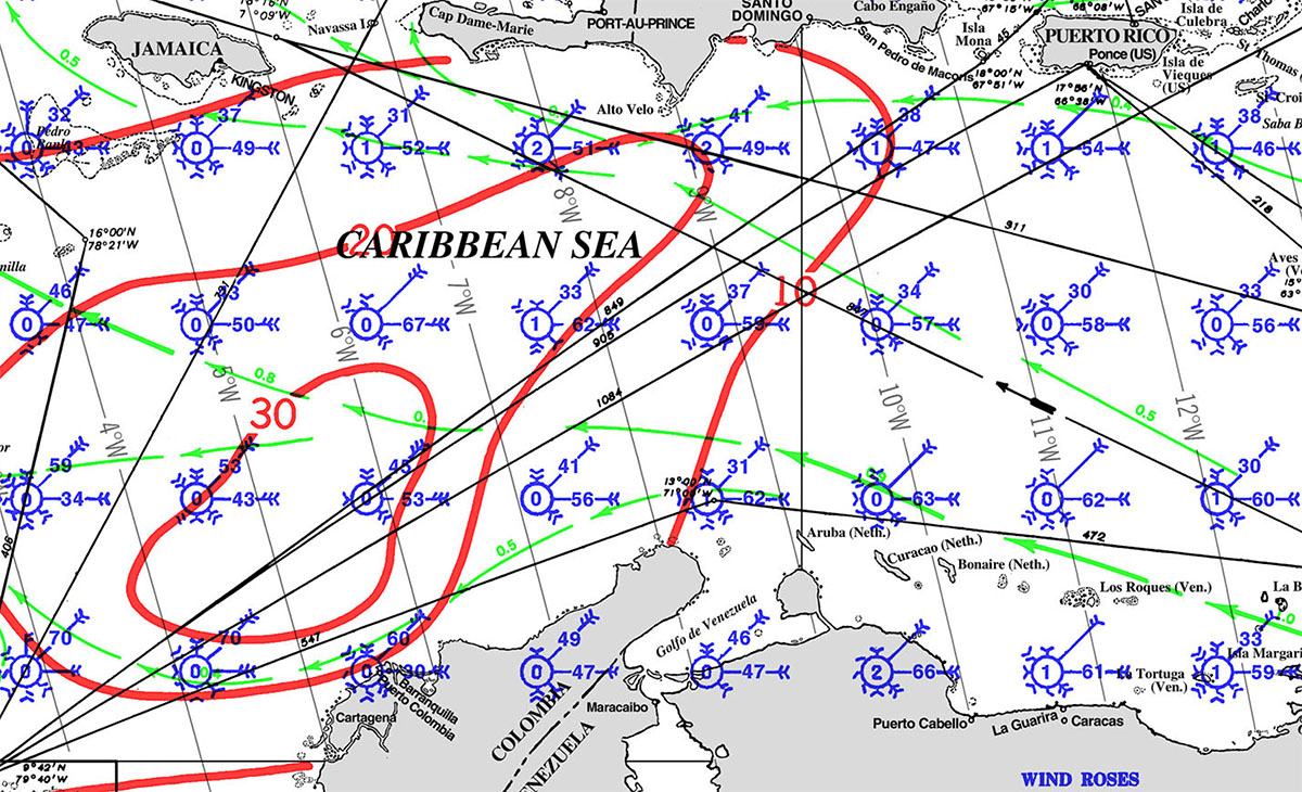
WEATHER
Prevalent trade winds bend along the coast from east really hard, especially along the northern eastern coast between late December through April. All year long however every near-shore winds will let up producing manageable jumps for vessels heading east. May through September, Colombia on the Caribbean side, faces long periods with hot and sticky conditions followed but thunderstorms and as a consequence you have minimal near-shore winds. Early fall can even produce westerlies. Winds and waves are significantly reduced closer to shore. As always do not sail on this coast on a schedule !
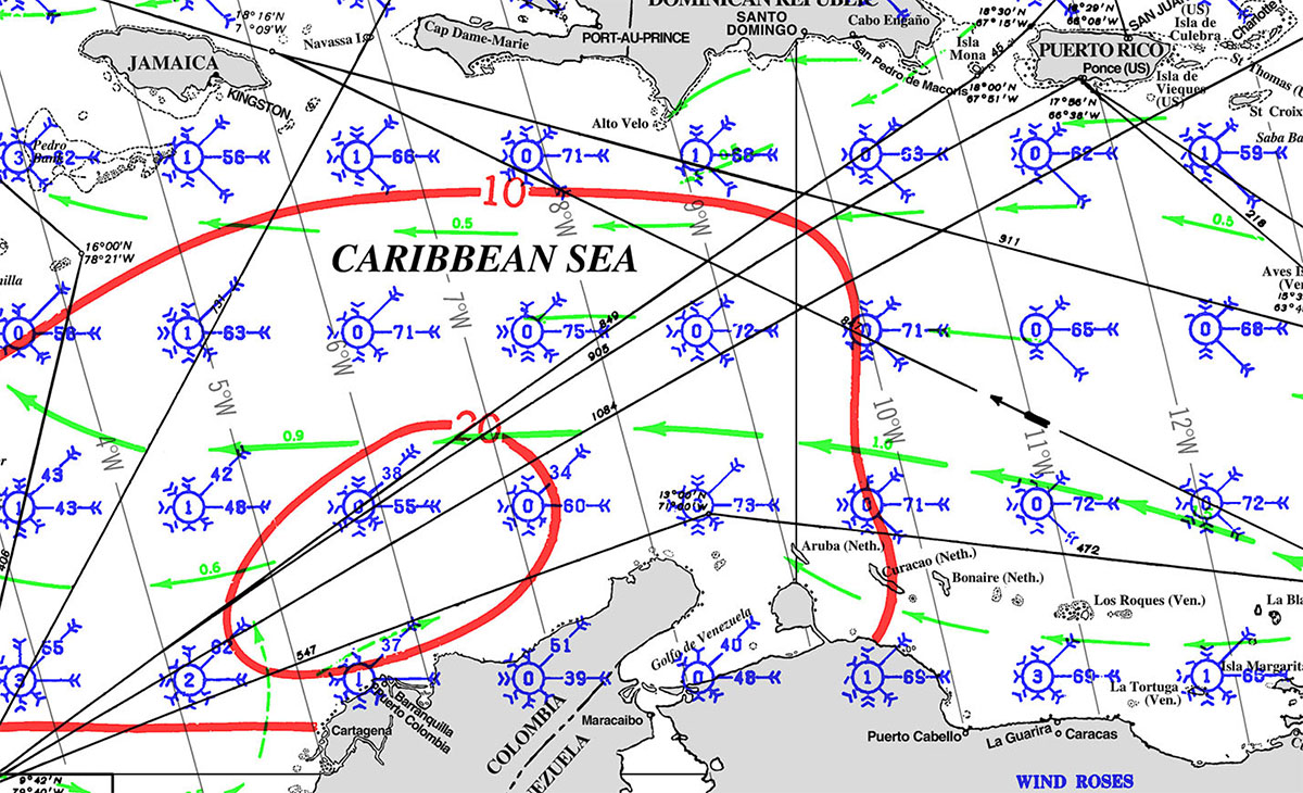
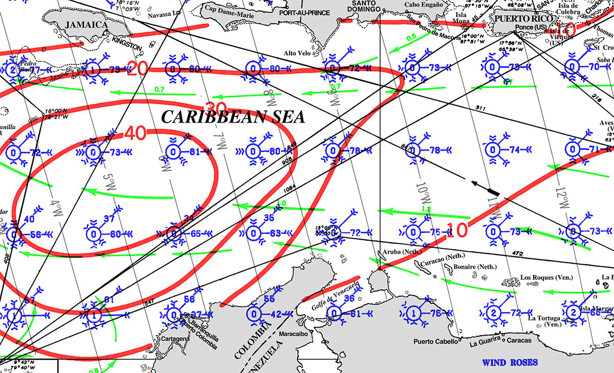
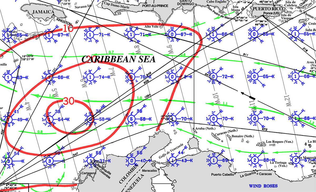
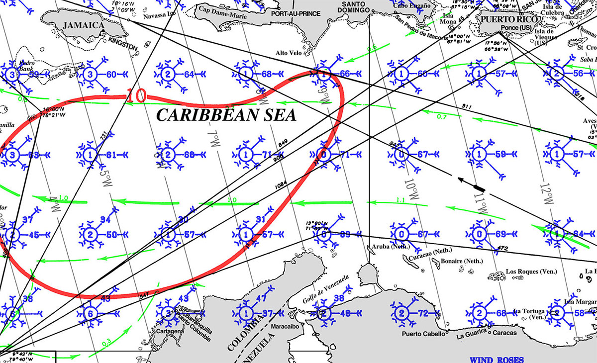
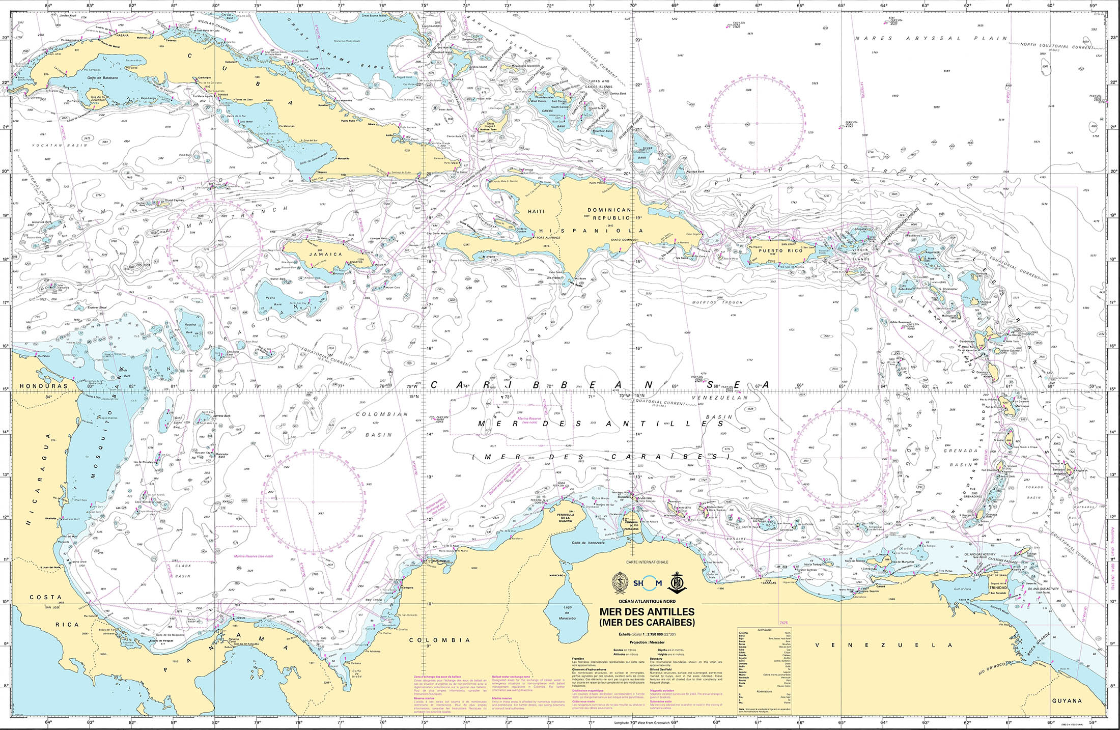
PILOT CHARTS
Pilot Charts depict averages in prevailing winds and currents, air and sea temperatures, wave heights, visibility, barometric pressure, and weather conditions at different times of the year. The information used to compile these averages was obtained from oceanographic and meteorologic observations over many decades during the late 18th and 19th centuries.The charts are intended to aid the navigator in selecting the fastest and safest routes with regards to the expected weather and ocean conditions. For an explanation of historic Colombian Climatology and how to read Wind-roses follow this link.

PORTS OF ENTRY
- Port of Willemstad
- Coordinates: 12°06.5’N, 68°55.3’W
- Details: This natural deep harbor is the main port of entry, located in the capital city. It offers a range of facilities and services for yachts of various sizes. Upon arrival, captains must present valid papers at the harbor office and proceed to register all passengers at the Immigration Office.
- Curaçao Marine
- Coordinates: 12°06.5’N, 68°55.0’W
- Details: Located near Willemstad, this marina is equipped with a large boatyard and offers various maintenance services. It’s a common port of entry for yachts needing work or extended stays.
- Spanish Water
- Coordinates: 12°05.1’N, 68°51.0’W
- Details: A popular anchorage spot for yachts, offering a sheltered environment. While not an official port of entry, it’s frequently used by sailors arriving in Curaçao.
DOCUMENTS
What documents do I need?
The beautiful island of Curaçao is ready to welcome you. Let’s make sure you are set with everything you need before your arrival.
CURAÇAO TRAVEL REQUIREMENTS:
Validity/Proof
- Your passport must not be more than 10 years old and must be valid during your entire stay.
- You must have proof that you can return to your country of departure, or transit to another country. This could be a passport, residence permit or visa.
- You can provide proof of the reason for your stay like a hotel reservation or an invitation from family or friends.
- You must fill out the Digital Immigration Card. For additional information visit our FAQs page.
- Visa (if applicable). Learn more about the visa-free countries and the exemption conditions here.
Travel Expenses
- You must have enough money to cover your stay and any other expenses.
The following guidelines apply:
– when staying in a hotel approximately 150 US dollar per person, per day,
– when staying with friends or family approximately 100 US dollar per person, per day.
No rights can be derived from these amounts.
Medical Coverage/Public Health
- You are advised to have valid medical insurance or travel insurance that covers medical expenses. The insurance should provide coverage for medical expenses and include hospital care, emergency treatment and repatriation (including in the event of death).
- Proof of vaccination against yellow fever (if applicable).
- You must not be considered a threat to public order, public health, national security, or international relations.
MUST SEE
- Willemstad (Historic Area)
- Coordinates: 12°06.4’N, 68°56.0’W
- Details: Willemstad, the capital of Curaçao, is a UNESCO World Heritage site known for its colorful Dutch colonial architecture. Key attractions include the Queen Emma Bridge, Punda and Otrobanda districts, and the floating market.
- Christoffel National Park
- Coordinates: 12°20.0’N, 69°04.0’W
- Details: This park features the island’s highest peak, Mount Christoffel, offering hiking trails with stunning views, as well as a variety of flora and fauna unique to Curaçao.
- Shete Boka National Park
- Coordinates: 12°22.0’N, 69°09.0’W
- Details: Known for its rugged coastline and sea caves, this park is a great place to witness the power of the ocean. Boka Tabla and Boka Pistol are particularly popular spots within the park.
- Klein Curaçao
- Coordinates: 11°59.5’N, 68°38.0’W
- Details: A small, uninhabited island located southeast of the main island, Klein Curaçao is famous for its pristine beaches, clear waters, and excellent snorkeling and diving opportunities. It also features an old lighthouse and shipwrecks.
- Playa Kenepa Grandi (Grote Knip)
- Coordinates: 12°21.3’N, 69°09.4’W
- Details: One of the most beautiful beaches in Curaçao, known for its crystal-clear turquoise water and picturesque surroundings, making it a favorite spot for swimming and snorkeling.
- Hato Caves
- Coordinates: 12°11.6’N, 68°57.2’W
- Details: These limestone caves offer guided tours showcasing impressive stalactites, stalagmites, and ancient petroglyphs. The caves are located near Curaçao International Airport.
- Sea Aquarium
- Coordinates: 12°04.5’N, 68°53.6’W
- Details: A popular attraction offering interactive marine experiences, including swimming with dolphins and feeding sharks and sea turtles. The Sea Aquarium Beach nearby is also a great spot for relaxation and water activities.
- Mambo Beach
- Coordinates: 12°04.5’N, 68°53.6’W
- Details: This lively beach area features bars, restaurants, and shops, making it a perfect spot for both daytime relaxation and nightlife.
REPAIRS AND SERVICE PROVIDERS
Curaçao Yacht Agency
Services:
- Yacht provisioning and supplies
- Technical maintenance and project management
- Customs and clearance handling
- Document handling
- Marina and berth bookings
General Marine Services
Common Services Offered:
- Fuel stations
- Chandlery (marine supplies and parts)
- Diving and snorkeling equipment rentals
- Waste disposal facilities
- Boat cleaning and detailing
- Yacht brokerage and insurance services
Notable Marina and Service Locations
Willemstad: The main hub for marine services, offering extensive facilities and easy access to the city’s amenities.
Spanish Water: Popular for anchorage and marinas, providing a range of services in a serene environment.
Contact Information and Booking
Curaçao Yacht Agency: Available 24/7 for yacht owners, captains, and crew, providing comprehensive support and services tailored to your needs. Contact via phone, email, or social media for assistance.
Tips for Using Marine Services in Curaçao
- Plan Ahead: Booking services in advance, especially during peak seasons, is essential due to high demand.
- Documentation: Ensure all necessary paperwork and permits are in order to avoid delays and complications.
- Local Knowledge: Utilize local agents and services to navigate regulations and find the best service providers.