
🇺🇸 CASTILLO SAN MARCOS
🇺🇸 CASTILLO SAN MARCOS, St Augustine Florida
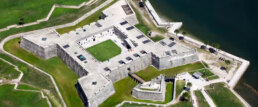
The Castillo de San Marcos is the oldest masonry fort in the continental United Statesand is located on the western shore of Matanzas Bay in the city of St. Augustine, Florida. The Castillo was designed by the Spanish engineer Ignacio Daza and construction begn in 1672, 107 years after the city's founding by Spanish Admiral and conquistador Pedro Menéndez de Avilés, when Florida was part of the Spanish Empire.

Castillo de San Marcos was for many years the northernmost outpost of Spain's vast New World empire. It is the oldest masonry fort and the best-preserved ex-ample of a Spanish colonial fortification in the continental United States. It anchored East Florida's defenses, which extended northward to the St. Marys River, westward to the St. Johns, and southward to Fort Matanzas. It protected St. Augustine from pirate raids and from Spain's major rival, Great Britain, during a time when the Florida-Georgia-Carolina coastline was an explosive international battleground.
![When Britain gained control of Florida in 1763 pursuant to the Treaty of Paris, St. Augustine became the capital of British East Florida, and the fort was renamed Fort St. Mark[8] until the Peace of Paris (1783) when Florida was transferred back to Spain and the fort's original name restored. In 1819, Spain signed the Adams–Onís Treaty which ceded Florida to the United States in 1821; consequently, the fort was designated a United States Army base and renamed Fort Marion, in honor of American Revolutionary War hero Francis Marion. The fort was declared a National Monument in 1924, and after 251 years of continuous military possession, was deactivated in 1933. The 20.48-acre (8.29 ha) site was subsequently turned over to the United States National Park Service. In 1942 the original name, Castillo de San Marcos, was restored by an Act of Congress.](https://oceanposse.s3.us-east-2.amazonaws.com/wp-content/uploads/2021/05/castillossanmarcos-1024x637.jpg)
The roots of the Castillo's history reach back to the years just after Christopher Columbus's final transatlantic voyage, when conquistadors carved out a vast and wealthy overseas empire for Spain, first in the Caribbean and then on the mainlands of Mexico, Central America, Colombia, Venezuela, and Peru. Products of these tropical and mountainous territories brought high prices on the Continent, and Spanish galleons sailed home laden with exotic dyes, sugar, tobacco, chocolate, pearls, hardwoods, and silver and gold. These so-called "treasure fleets" made Spain the most powerful and envied nation in Renaissance Europe.

Thanks to the travels of Ponce de Leon in 1513, Spanish navigators knew that the best return route from Spain's rich Caribbean possessions was along the Gulf Stream, through the Bahama Channel, and past the shores of Florida. The Spanish knew they must defend this peninsula to prevent enemies from using its harbors as havens from which to raid the passing treasure fleets.

In 1513 Spain claimed Florida through the expedition of Ponce de Leon, but France gained the first foothold there by establishing Fort Caroline on the St. Johns River in 1564. Seeing this as both a challenge to Spain's claims and a menace to the treasure fleets, King Philip II sent an expedition under Don Pedro Menendez de Aviles to eliminate the French threat and establish settlements in Florida. It arrived at the mouth of the St. Johns River in September 1565.
After attempting unsuccessfully to board the French ships anchored there, Menendez sailed to a harbor farther south and established St. Augustine as a base for further operations. Almost immediately a French fleet sailed south to attack. But the ships were driven southward and wrecked by a violent storm and the mission failed. Realizing that Fort Caroline would be lightly guarded, the Spaniards marched north, captured the fort, and executed most of the inhabitants.

The same fate befell survivors from the French fleet, whom the Spaniards captured and killed at an inlet 14 miles south of St. Augustine. The episode gave a name to the area: Matanzas, Spanish for "slaughters."

England became Spain's next contender for Florida. The Spanish had watched the English warily ever since Sir Francis Drake attacked and burned St. Augustine in 1586. They became even more watchful after English-men settled Jamestown in 1607. British pirates sacked St. Augustine again in 1668, and this hit-and-run attack, followed by the English settlement of Charleston in 1670, caused Spain to build the Castillo de San Marcos.


Begun in 1672 and completed by 1695, the Castillo replaced nine successive wooden fortifications that had protected St. Augustine since its founding. The fort's commanding location on the west bank of Matanzas Bay allowed its guns to protect not only the harbor entrance but the ground to the north against a land attack.

The Castillo's baptism of fire came in 1702 during the War of the Spanish Succession, when the English occupied St. Augustine and unsuccessfully besieged the fort for 50 days. The English burned the town before they left, but the Castillo emerged unscathed, thereby making it a symbolic link between the old St. Augustine of 1565 and the new city that rose from the ashes.

When Britain gained control of Florida in 1763 pursuant to the Treaty of Paris, St. Augustine became the capital of British East Florida, and the fort was renamed Fort St. Mark[8] until the Peace of Paris (1783) when Florida was transferred back to Spain and the fort's original name restored. In 1819, Spain signed the Adams–Onís Treaty which ceded Florida to the United States in 1821; consequently, the fort was designated a United States Army base and renamed Fort Marion, in honor of American Revolutionary War hero Francis Marion. The fort was declared a National Monument in 1924, and after 251 years of continuous military possession, was deactivated in 1933. The 20.48-acre (8.29 ha) site was subsequently turned over to the United States National Park Service. In 1942 the original name, Castillo de San Marcos, was restored by an Act of Congress.

Castillo SAN MARCOS Timeline
- 1513 Sailing from Puerto Rico, Spanish claim Florida.
- 1565 Spanish found St. Augustine and destroy French at Fort Caroline and Matanzas Inlet.
- 1672 Ground is broken on October 2 for Castillo de San Marcos.
- 1695 Castillo de San Marcos (curtain walls, bastions, living quarters, moat, ravelin, and sea-wall) is finished in August.
- 1702 War of the Spanish Succession pits Spain and France against Austria, Great Britain, and others. Coastal Georgia missions are destroyed by Carolinians en route to St. Augustine. Carolinians occupy and burn St. Augustine but the Castillo successfully resists their siege.
- 1738 Spanish governor at St. Augustine grants freedom to runaway British slaves. Black families settle at new town called Fort Mose.
- 1740 St. Augustine successfully endures siege by British, Georgian, and South Carolinian forces. Spanish attack and de-feat British Highland troops camped at Fort Mose.
- 1740-42 Fort Matanzas is built to block southern approach to St. Augustine.
- 1756-62 Fort Mose re-built in masonry. Earth-works at Mose extended to complete northern-most defense.
- 1763 Peace of Paris gives Florida to Great Britain in exchange for La Habana. Castillo becomes known as Fort St. Mark.
- 1783 Peace of Paris recognizes independence of the United States and returns Florida to Spain.
- 1821 Spain cedes Florida to the United States.
- 1825 Castillo de San Marcos renamed Fort Marion.
- 1924 Fort Marion and Fort Matanzas are proclaimed national monuments
- 1933 Transferred to the National Parks Service
- 1942 Original name Castillo San Marcos is restored
GET THERE BY YACHT

Sierra de San Francisco Murals 🇲🇽 Mexico
Rock Paintings of the Sierra de San Francisco 🇲🇽 BAJA CALIFORNIA Mexico
From c. 100 B.C. to A.D. 1300, the Sierra de San Francisco (in the El Vizcaino reserve, in Baja California) was home to a people who have now disappeared but who left one of the most outstanding collections of rock paintings in the world. They are remarkably well-preserved because of the dry climate and the inaccessibility of the site.
The central part of Baja California peninsula is a region of Mexico that concentrates one of the most extraordinary repertoires of rock art in the country, the Rock Paintings of the Sierra de San Francisco. The region is insular-like and kept the native peoples relatively isolated from continental influences, allowing the development of local cultural complex. One of the most significant features of the peninsular prehistory is the mass production of rock art since ancient times and the development of rock art tradition of the Great Murals.

The Sierra de San Francisco is the mountain range which concentrates the most spectacular and best preserved Great Mural sites, scale wise one of the largest prehistoric rock art sites in the world. Hundreds of rock shelters, and sometimes huge panels with hundreds and even thousands of brightly painted figures, are found in a good state of conservation. The style is essentially realistic and is dominated by depictions of human figures and marine and terrestrial fauna, designed in red, black, white and yellow, which illustrate the relationship between humans and their environment, and reveal a highly sophisticated culture. The paintings are found on both the walls and roofs of rock shelters in the sides of ravines that are difficult of access. Those in the San Francisco area are divided into four main groups – Guadalupe, Santa Teresa, San Gregorio and Cerritos. The most important sites are Cueva del Batequì, Cueva de la Navidad, Cerro de Santa Marta, Cueva de la Soledad, Cueva de las Flechas and Grutas del Brinco.
The landscape of the area is another significant attribute, understood as the extensive physical space in which, through rock art, the thoughts of their early dwellers, hunter-gatherers people who living here from the terminal Pleistocene (10,000 BP) until the arrival of Jesuit missionaries in the late seventeenth century, are expressed.
North of San Ignacio lies a mountain wilderness, the deeply eroded remains of layer upon layer of volcanic outpourings. This rugged mass rises from the surrounding desert to heights of more than 5,000 feet and covers an area 35 miles from north to south and half of that from east to west. From its uplands, there are views west to Scammon’s Lagoon and the Vizcaíno Desert, northwest to the even taller Sierra de San Borja, and east to the abrupt eminences of Las Tres Vírgenes, taller and more recent volcanos that tower in front of the Gulf. The sierra embraces a world that would never be suspected from the low, barren lands outside. Groves of palms and pools of water are set between walls of vertical grandeur water-carved from rich-colored rock. A few ranches, built by rustic and hospitable people, nestle near the few water sources. Here also are the grandest reminders of the Painters, corridors decorated by their hands and haunted by their spirits.

Showing human figures and many animal species and illustrating the relationship between humans and their environment, the paintings reveal a highly sophisticated culture. Their composition and size, as well as the precision of the outlines and the variety of colors, but especially the number of sites, make this an impressive testimony to a unique artistic tradition.
Cultural traditions, with roots back to the XVIII century, persist and the Sierra has a strong social value in the role that culture plays in the preservation of the traditional links between mountain communities and the South Californians and Mexicans in general.
Integrity
The Rock Paintings of the Sierra de San Francisco encompass an area of 183, 956 ha, where more than 400 sites have been recorded, the most important of them within the reserve, near San Francisco and Mulege, over 250 in all. The inscribed property contains an exceptional repertoire of rock art that convey its Outstanding Universal Value. The sites have remained virtually intact and still have a good state of conservation. The integrity of rock painting sites and their surroundings has been maintained largely due to the situation of isolation and the low population density that prevails in the region.
Protection and management requirements
The Rock Paintings of the Sierra de San Francisco are protected by the 1972 Federal Law on Historic, Archaeological and Artistic Monuments and Zones and fall under the protective and research jurisdiction of National Institute of Anthropology and History (INAH). In addition, the property is entirely within the Vizcaino Biosphere Reserve; which grants it with additional protection. The Management Plan has been in operation since 1994 and has proved a successful strategy in the administration of cultural resources of the property. This model emphasizes the importance of defining the meaning of this heritage site, so that all management strategies are consistently directed toward the preservation of the values that make it important. Another key feature is the total involvement of all those groups that have an interest in the area under discussion. The Management Plan focuses on issues such as mitigation of the impact of visitors on sites and control and monitor of access. Some measures included the installation of reversible infrastructure in seven of the most visited rock painting sites and the definition of authorized access paths, the areas open to the public or restricted, and four levels of access for tourists. This system allows visitors to experience a wide range of sites and at the same time protects the majority of those who are very well preserved. In this sense the most popular sites have remained open under this Management Plan. Threats remain that have to be addressed, including those derived from the proposals to construct roads within the protected area which would jeopardize the existing integrity between the landscape and the rock art sites.

The medium and long term management expectations include obtaining additional legal protection through the presidential declaration of the area; allocating permanent custodian positions to improve monitoring, enhance the administrative and technological infrastructure of Sierra de San Francisco Information Unit located in San Ignacio town, capacity building for the custodians and guides and improvement of low-impact infrastructure for services.


more at https://www.bradshawfoundation.com/baja/great_mural_styles/index.php
JOIN THE OCEAN POSSE TO CRUISE AND SAIL 🇲🇽 THE SEA OF CORTES
Introduction
Nestled in the heart of Baja California, Mexico, the Sierra de San Francisco is home to some of the most remarkable and enigmatic prehistoric rock art in the world. The murals of Sierra de San Francisco, created by the ancient Cochimi people, offer a captivating glimpse into the region’s rich cultural history and prehistoric life. These murals are not just artistic expressions but are also a testament to the spiritual and social fabric of the ancient inhabitants.
Historical Background
The rock art of Sierra de San Francisco dates back to at least 1,000 BCE and continued to be created until the arrival of Europeans in the 18th century. The Cochimi, who were hunter-gatherers, are believed to have created these murals as part of their spiritual and social rituals. The Sierra de San Francisco murals were first brought to wider attention by European explorers in the late 18th and early 19th centuries.
In 1989, UNESCO recognized the cultural significance of these murals by designating them a World Heritage Site. This designation has helped protect the site and promote it as an essential destination for historians, archaeologists, and travelers alike.
Geographical Setting
The Sierra de San Francisco is part of the Baja California Peninsula’s central mountain range. This rugged and remote area is characterized by steep canyons, dramatic cliffs, and arid desert landscapes. The isolation of the region has helped preserve the murals in a relatively untouched state, offering an authentic glimpse into the ancient world.
The rock art is located in numerous caves and rock shelters scattered throughout the region. Accessing these sites often requires a challenging journey by foot or mule, adding to the sense of adventure and discovery for visitors.
Artistic and Cultural Significance
The murals of Sierra de San Francisco are renowned for their size, complexity, and vivid colors. They depict a variety of subjects, including human figures, animals, and abstract symbols. The human figures are often shown in dynamic poses, engaging in activities such as hunting, dancing, and ritual ceremonies. Animals such as deer, rabbits, mountain lions, and birds are also frequently depicted, reflecting their importance in the daily life and spiritual beliefs of the Cochimi.
The use of color in these murals is particularly striking. The artists employed natural pigments derived from minerals and plants to create red, black, white, and yellow hues. These colors have remained remarkably vibrant over the millennia, a testament to the skill and knowledge of the ancient artists.
The murals are more than mere decorations; they are believed to have held significant spiritual and ceremonial importance. Many researchers suggest that the art was created as part of religious rituals, possibly to ensure successful hunts, invoke protection, or celebrate important community events.
Key Sites and Murals
Several key sites within the Sierra de San Francisco stand out for their exceptional rock art. Here are some of the most notable:
- Cueva del Ratón: This cave is one of the most accessible and well-known sites in the Sierra de San Francisco. The murals here depict a variety of human and animal figures in vivid colors, with some scenes showing groups of people engaged in what appears to be a ritual dance. The sheer scale and detail of the artwork make it a must-see for visitors.
- Cueva Pintada: Known as the “Painted Cave,” this site contains some of the most intricate and detailed murals in the region. The artwork here features large human figures adorned with headdresses and intricate patterns, suggesting a high degree of social and ceremonial importance.
- Cueva de las Flechas: This site is famous for its depiction of hunting scenes. The murals show human figures armed with bows and arrows, hunting deer and other animals. The dynamic poses and detailed rendering of the figures provide a fascinating insight into the hunting practices of the ancient Cochimi.
- Cueva de San Borjitas: This cave contains some of the oldest known murals in the region, with some estimates dating the artwork to around 7,500 years old. The murals here are notable for their abstract designs and symbols, which continue to intrigue researchers and archaeologists.
Preservation and Conservation
Preserving the Sierra de San Francisco murals is a critical concern for both the Mexican government and international organizations. The remote location of the murals has helped shield them from much of the damage caused by human activity, but they are still vulnerable to natural erosion and the impact of increasing tourism.
Efforts to protect the murals include restricting access to certain sites, providing guided tours to minimize damage, and educating visitors about the cultural and historical significance of the art. Local guides, often descendants of the Cochimi people, play a vital role in these conservation efforts by sharing their knowledge and fostering a deeper appreciation for the murals.
UNESCO’s designation of the area as a World Heritage Site has also been instrumental in securing funding and support for ongoing preservation efforts. These initiatives aim to ensure that the murals remain a source of cultural and historical knowledge for future generations.
Visitor Experience
Visiting the Sierra de San Francisco murals is a unique and rewarding experience, combining the thrill of exploration with the opportunity to connect with ancient history. The journey to the murals often involves traveling by mule or on foot through rugged terrain, offering a sense of adventure and a chance to appreciate the stunning natural beauty of the region.
Local guides provide invaluable insights into the history and significance of the murals, enhancing the visitor experience with stories and explanations that bring the artwork to life. Many tours also include visits to traditional Cochimi settlements, allowing visitors to gain a deeper understanding of the region’s cultural heritage.
The Future of the Sierra de San Francisco Murals
The future of the Sierra de San Francisco murals depends on a delicate balance between preserving these ancient treasures and promoting them as a cultural and tourist attraction. Sustainable tourism practices, ongoing conservation efforts, and increased awareness of the murals’ significance are all crucial to ensuring their survival.
As researchers continue to study the murals, new discoveries and insights are likely to emerge, further enriching our understanding of the ancient Cochimi people and their world. The murals of Sierra de San Francisco stand as a testament to human creativity and resilience, offering a window into a distant past that continues to inspire and captivate those who visit.
THE JOURNEY TO GET THERE – STAY AT PUERTO ESCONDIDO MARINA IN THE SEA OF CORTEZ
The journey to see the murals is an adventure in itself, offering stunning natural landscapes and a deep connection to the past. Through ongoing preservation efforts and sustainable tourism practices, we can ensure that these ancient masterpieces remain a source of wonder and inspiration for generations to come. The murals of Sierra de San Francisco are not just a testament to a lost civilization but a celebration of human creativity and the enduring power of art to transcend time.