Primary Named Winds in the Mediterranean
| Wind Name | Direction | Temperature | Notes |
Bora |
NE | Cold & dry |
Katabatic wind, especially violent in N Adriatic; sudden gusts, winter stronger.
|
The Major Bora Wind Funnels Areas in the Adriatic
1. Southern Gulf of Trieste
2. Bay of Rijeka with the Kvarner Gulf
3. Coastline of Senj and the strait between Krk and Prvić
4. Velebit Channel between the eastern coast of Rab and Jablanac
5. Šibenik to Cape Ploča
6. Vrulje Bay between Omiš and Makarska
7. Northwest exit of the Mljetski Channel
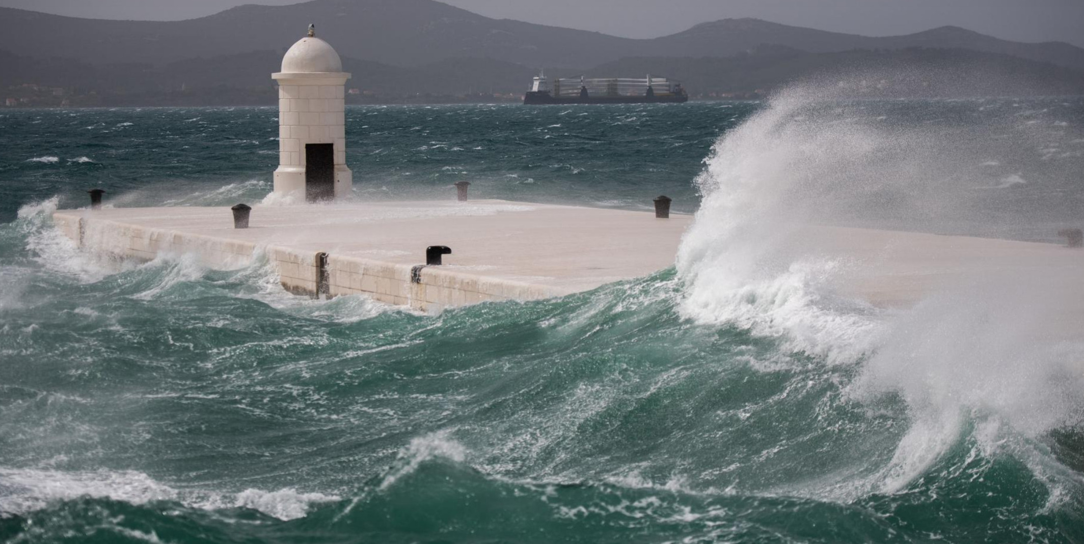
The Bora is one of the most infamous winds in the Mediterranean — especially for sailors in the Adriatic Sea, and particularly along the coast of Croatia, Slovenia, and NE Italy. Here’s a breakdown of its effects on sailing:
🌬️ Bora Wind – Quick Facts
-
Direction: Blows from the northeast (NE) — offshore in most of the Adriatic.
-
Temperature: Cold and dry, especially in winter.
-
Origin: A katabatic wind, meaning it funnels down from high elevations (like the Dinaric Alps) and accelerates downhill toward the sea.
⛵ Effects on Sailing
✅ Advantages (if timed carefully):
-
Great downwind sailing from NE to SW if you’re headed south along the Adriatic.
-
Clear skies and visibility often accompany it once the wind stabilizes.
-
Flat seas may briefly appear at onset — before wave build-up begins.
⚠️ Risks & Challenges:
-
Sudden onset — the Bora can go from 5 knots to 45+ knots in minutes.
-
Gusts over 60 knots are not uncommon — especially near Trieste, Senj, and Velebit Channel.
-
Dangerous crosswinds when sailing parallel to the coast — especially for boats exiting or entering harbors.
-
Short steep waves build up quickly in open water — very uncomfortable and hazardous.
-
Anchor dragging is a common hazard; the wind can blow straight offshore and expose poor holding.
⚓ Strategic Advice for Sailors:
-
Shelter on the lee side of islands or in well-protected harbors with NE protection.
-
Use Bora forecasts — many local services (e.g., Croatia’s met service) provide alerts.
-
Secure anchorage with extra scope, especially in exposed NE-facing bays.
-
Avoid passages from Italy to Croatia during a strong Bora unless you’re highly experienced and your vessel is ready.
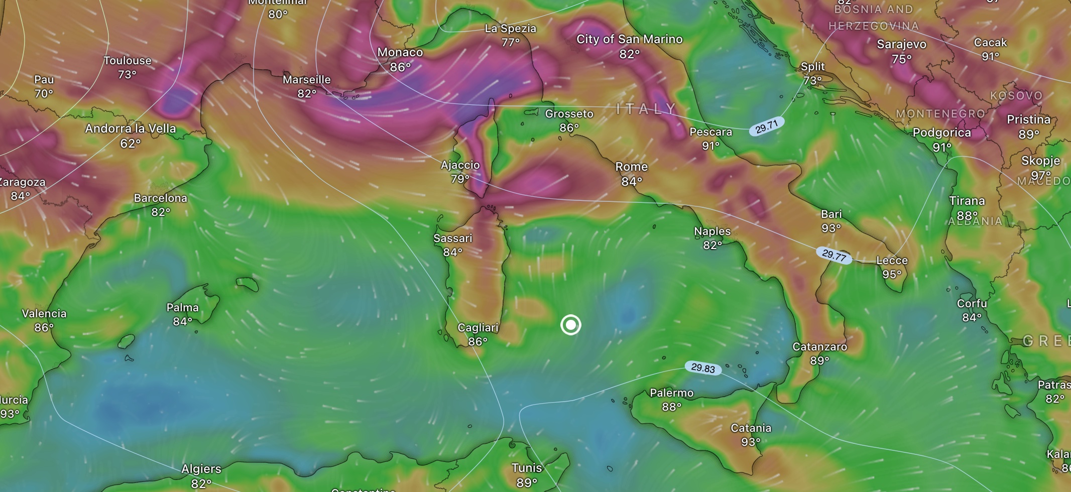
WINDS
Current
SWELL AND WAVES
The gregale wind is a northeast wind. It’s a strong, cold, and dry wind that primarily affects the western and central Mediterranean regions, particularly in winter.
The Gregale (Catalan: Gregal, Croatian: Gregal, Italian: Grecale, Lombard: Grecal, Maltese: Grigal, Occitan: Gregau, Greek: Γραίγος, Graigos) Is A Mediterranean Wind That Can Occur During Times When A Low-pressure Area Moves Through The Area To The South Of Malta And Causes A Strong, Cool, Northeasterly Wind To Affect The Island. It Also Affects Other Islands Of The Western Mediterranean. The Italian Name “Grecale” Could Be Translated As Greek Wind, As The Wind Starts At The Ionian Island Zakynthos.

The Karaburun winds, specifically in the Karaburun peninsula of Turkey, are generally known for being westerly winds, meaning they blow from west to east. The peninsula’s location jutting out into the Aegean Sea makes it susceptible to these prevailing winds. The wind direction can be influenced by local topography and weather patterns, but the general trend is from the west.
These winds are primarily part of the broader Etesian (or Meltemi) wind system, but the unique geography of Karaburun amplifies and funnels these winds, giving them a distinct local character.
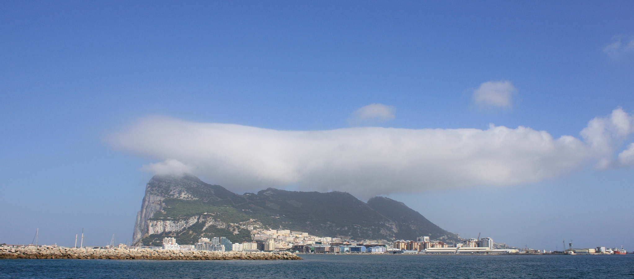
The Levante wind, also known as Levanter, is a warm, easterly wind prevalent in the western Mediterranean, particularly in the Strait of Gibraltar. It’s known for its strength and persistence, often causing rough seas and reducing visibility due to mist or dust
| Name | Direction | Region | Effect on Sailing |
Libeccio |
SW | Western Mediterranean |
Moist and gusty; often brings squalls; rough lee shores in Italy’s Tyrrhenian coast.
|
The Libeccio is a warm, moist southwesterly wind that affects the western Mediterranean, particularly the Tyrrhenian Sea, Corsica, Sardinia, and the coastal regions of Italy and southern France.
Key Sailing Facts:
• Direction: Blows from the SW (225°), pushing toward the NE.
• Strength: Can range from moderate breezes to gale-force winds, especially when associated with low-pressure systems moving across the Mediterranean.
• Sea Conditions: Kicks up heavy, confused seas and long swell—especially along west-facing shores. This can make anchorages on those coasts untenable.
• Weather Setup: Linked to Atlantic-born depressions moving eastward. The Libeccio often arrives ahead of a front, bringing rain, thunderstorms, and humid air.
• Affected Areas:
◦ Western Corsica & Sardinia – strong swells and difficult anchorages
◦ Italian Riviera, Genoa, La Spezia – rough seas and coastal flooding risk
◦ Strait of Bonifacio – can be hazardous due to funnelling effect
Navigational Risk:
• The Libeccio is deceptive—it may build quickly and shift unpredictably. It also affects harbor entrances and swell-exposed ports, especially those facing W to SW.
• In narrow channels and between islands (like the Strait of Bonifacio), wind acceleration can be severe.
Name & Origins:
• From the Latin “Lips” (originally Greek), meaning west.
• In regional Italian dialects, it can also be called “Africo”, reflecting its African origins as it often carries warm, humid air from the Maghreb.
Captain’s Tip:
When planning a crossing from mainland Italy to the western isles or vice versa, check for incoming Libeccio systems—they can trap you on a lee shore with poor holding. In harbors open to the SW, move early or hunker down tight.
Best avoided offshore unless well-prepared and on a downwind run.
Meltemi Winds – Aegean Summer Sailing
During the summer months in Greece, a regional pressure gradient sets the stage for the Meltemi Winds, a dominant weather pattern in the Aegean Sea. A high-pressure system builds over the Balkans, while a thermal low develops over Turkey. This contrast draws strong northerly winds across the Aegean, especially from mid-June through September.
The Meltemi typically peaks during the day and eases overnight. It’s driven in part by the differential heating of land and sea—hot air over the mainland rises, pulling in cooler air from the north and northeast. While sometimes referred to as part of a broader Siberian High or influenced by distant pressure systems like the Aleutian Low, the main mechanism is regional and seasonal.
For sailors, the Meltemi is a double-edged sword. Its strength and reliability make for exhilarating passages under sail, but conditions can quickly become challenging:
-
Wind Strength: Regularly force 5–7 Beaufort, occasionally higher in funneling channels like between Andros and Tinos or around the Cyclades.
-
Sea State: Builds rapidly, especially in open fetch areas—expect steep, short-period waves.
-
Anchoring: Secure holding is essential; some anchorages offer poor protection from the north.
-
Harbor Entries: Crosswinds can complicate docking maneuvers, especially in small island ports.
-
Nighttime Lulls: Winds often ease at night, but not always—plan passages accordingly.
Still, for experienced cruisers prepared for spirited conditions, the Meltemi offers a uniquely Greek sailing experience—dry, cool, and beautifully bracing on a hot July afternoon.
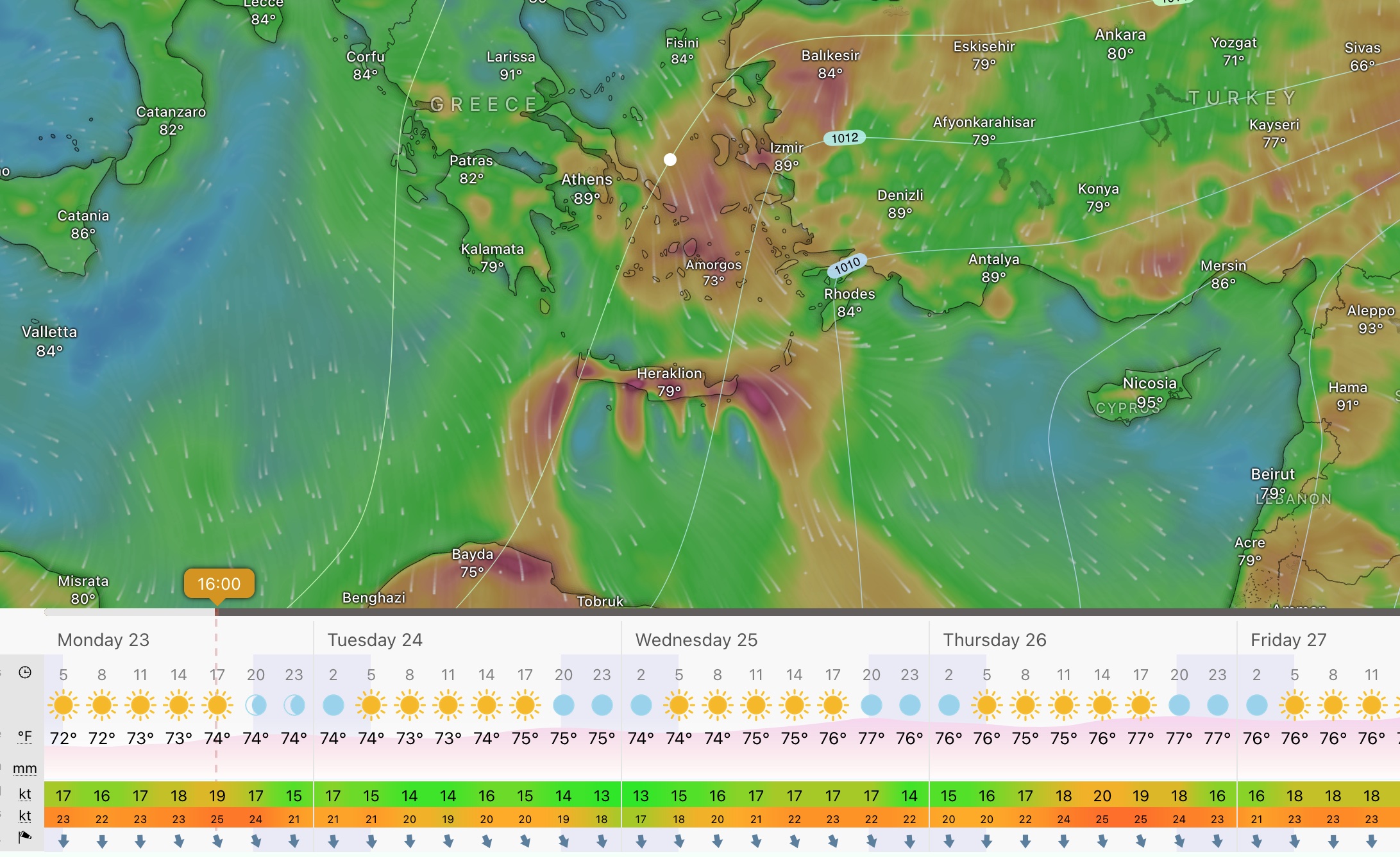
I’m on a leg from Paros to Amorgos. Forecast said Meltemi 20–25 knots, but it’s gusting well past 30. I feel it in my gut as soon as we clear the lee of Naxos—whitecaps stacked up, the boat punching through chop. The autopilot doesn’t like it. I take over.
The rhumb line looks simple on paper, but out here, it feels wrong. Every time I try to follow it, the motion gets worse—slamming, twisting. I fall off course a few degrees and everything settles. The boat sails smoother, we’re moving fast, even if it’s not the shortest path. I feel a little relief in my shoulders.
I’d planned to anchor at Katapola, but by the time we’re three miles out, it’s clear the wind’s still funnelling straight into the bay. I change course mid-channel and aim for the south side—Kalotaritissa. Fewer boats, more swell, but the wind angle gives me better control getting in. I get the hook down, deep sand. I feel it bite.
The next day, wind dies around 6 a.m. I leave at 6:15. Quiet engine hum, flat sea, no stress. I motor north while it lasts. By 9, the breeze is back and we’re close-hauled again. No drama this time—we made miles before it built.
Same story between Ios and Sifnos. A friend tried to stick to the straight route and turned back. I zigzagged a bit but made it in—tired, sunburnt, but not battered.
It keeps happening like that. I sketch plans, then adapt. Sometimes the detours save the day.
MISTRAL
It affects the northeast of the plain of Languedoc and Provence to the east of Toulon, where it is felt as a strong west wind. It has a major influence all along the Mediterranean coast of France, and often causes sudden storms in the Mediterranean between Corsica and the Balearic Islands.
The mistral is usually accompanied by clear, fresh weather, and it plays an important role in creating the climate of Provence. It can reach speeds of more than 49 knots, particularly in the Rhône Valley. Its average speed during the day can reach about 27 kn, calming noticeably at night. The mistral usually blows in winter or spring, though it occurs in all seasons. It sometimes lasts only one or two days, frequently lasts several days, and sometimes lasts more than a week.
It produces sustained winds averaging 27 knots sometimes reaching 54 knots.
It can last for several days.
Periods of the wind exceeding 16 knots for more than sixty-five hours have been reported. It is most common in the winter and spring, and strongest in the transition between the two seasons.

WINDS
Current
SWELL AND WAVES
Ostro (Croatian: Oštro)
It is a warm and humid wind that often carries rain, but it is also sometimes identified with the Libeccio and Sirocco. The winds of the Mediterranean.
It is a southerly wind in the Mediterranean Sea, especially the Adriatic. Its name is Italian, derived from the Latin name Auster, which also meant a southerly wind. It is a warm and humid wind that often carries rain, but it is also sometimes identified with libeccio and sirocco.
| Name | Direction | Region | Effect on Sailing |
PONIENTE |
W | Gibraltar -> Western Med |
Effect on the Sea: Produces calmer seas with smaller waves, making conditions better for nautical activities
|
Poniente (Ponente) – a warm and dry westerly or northwesterly wind blowing in the Straits of Gibraltar and along the coasts of the north-western Mediterranean. It’s the opposite of the Levante (Levanter) and it can switch frequently with this wind throughout the year. Synoptically the Poniente is more or less any westerly wind in this area. However, during winter and spring the pre-frontal Levante may turn into a southwesterly squally gale, known as Vendaval. Once the cold front has passed and high pressure builds up again, winds turn westerly or northwesterly and are now called Poniente. During Poniente-days visibility increases significantly and the opposite shores of Africa can be seen from Gibraltar. The Poniente (or wind from the west), however, brings hot, clear and mostly dry weather. In other areas of the Mediterranean the Ponente is known as a land-breeze around the Gulf of Lion, as a weakened flow from the Mistral on the Cote d’Azur and over the Ligurian Sea, where it often precedes the Tramontana.
| Name | Direction | Region | Effect on Sailing |
Tramontane |
N or NW | Western Med, Languedoc & Catalonia |
Similar to the Mistral but often drier and colder; comes through Pyrenees; flattens seas initially.
|

The Tramontane is a strong, dry, and often violent northwesterly wind that funnels down from the Massif Central and Pyrenees toward the Gulf of Lion, impacting the southern French regions of Languedoc-Roussillon and Occitanie. It is a close cousin of the Mistral, though it tends to blow from a slightly more westerly direction.
Key Facts for Sailors :
• Direction: NW to SE (offshore from the French coast into the Mediterranean).
• Strength: Often reaches 30–50 knots, with gusts up to 140 km/h (75 knots) not uncommon.
• Frequency: Historically active around one day out of three, though in 2022, activity dropped to record lows.
• Weather Setup: Caused by a pressure gradient between a high over the Bay of Biscay or Spain and a low over the Gulf of Genoa or southern Med. Cold continental air accelerates as it descends through mountain valleys.
• Sea Conditions: Produces short, steep waves and rough offshore seas, especially dangerous when transitioning to calmer Mediterranean waters.
• Navigational Risk: Sudden onset, highly gusty. Sheltering near lee shores can become dangerous. Best avoided or carefully planned around when sailing out of Port-Camargue, Sète, Leucate, Gruissan, or Collioure.
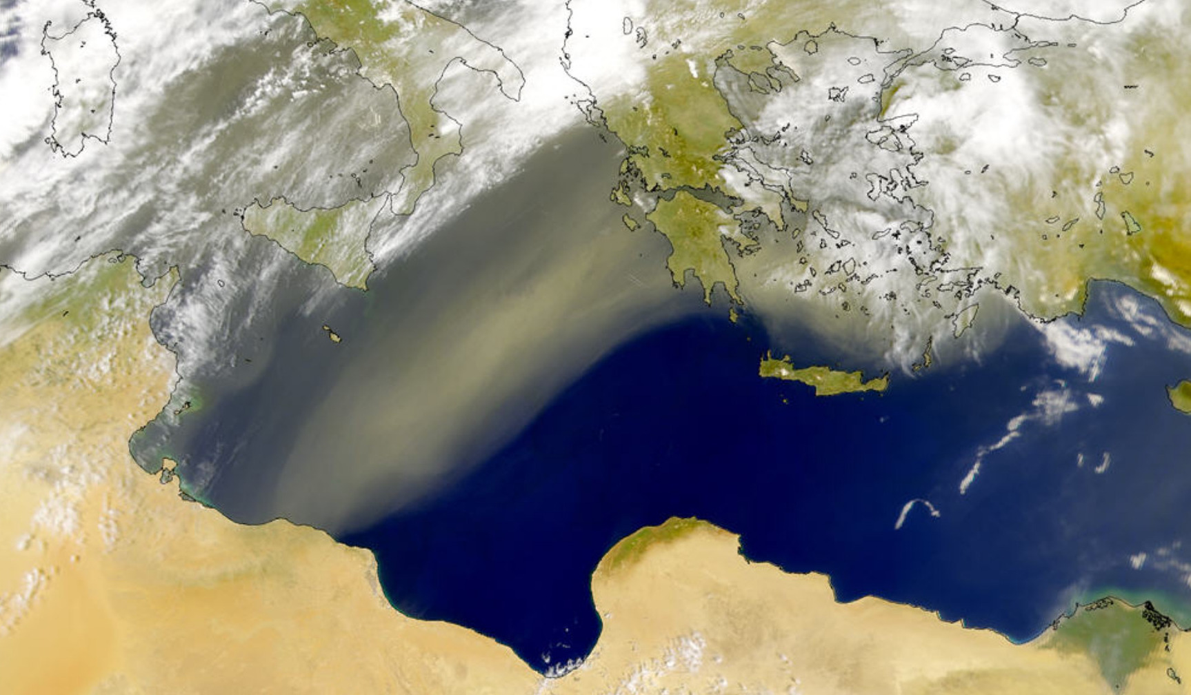
Siroccos arise from warm, dry, tropical air masses that are pulled northward by low-pressure cells moving eastward across the Med with the wind originating in the Arabian or Sahara deserts. The hotter, drier continental air mixes with the cooler, wetter air and the counter-clockwise circulation of the low propels the mixed air across the southern coasts of Europe.
Effects
The sirocco causes dusty dry conditions along the northern coast of Africa, storms in the Mediterranean Sea, and warm wet weather in Southern Europe. The sirocco does not affect other parts of Europe. The sirocco’s duration may be as short as half a day or may last several days. While passing over the Mediterranean Sea, the sirocco picks up moisture; this results in rainfall in the southern part of Italy known locally as “blood rain” due to the red sand mixed with the falling rain.
- The dust can irritate the respiratory system, triggering asthma attacks and other breathing difficulties.
- The high temperatures and low humidity can lead to heatstroke, dehydration, and other heat-related illnesses.
- Some people experience headaches, insomnia, and general unease during Sirocco events due to the heat, dust, and humidity.
- The dry and hot conditions associated with Sirocco winds can exacerbate the risk of wildfires, especially during the summer months when vegetation is already dry.
- The dust can significantly reduce visibility, impacting transportation and other activities.