

Navigating Gibraltar: Sailing into and out of the Strait
Introduction
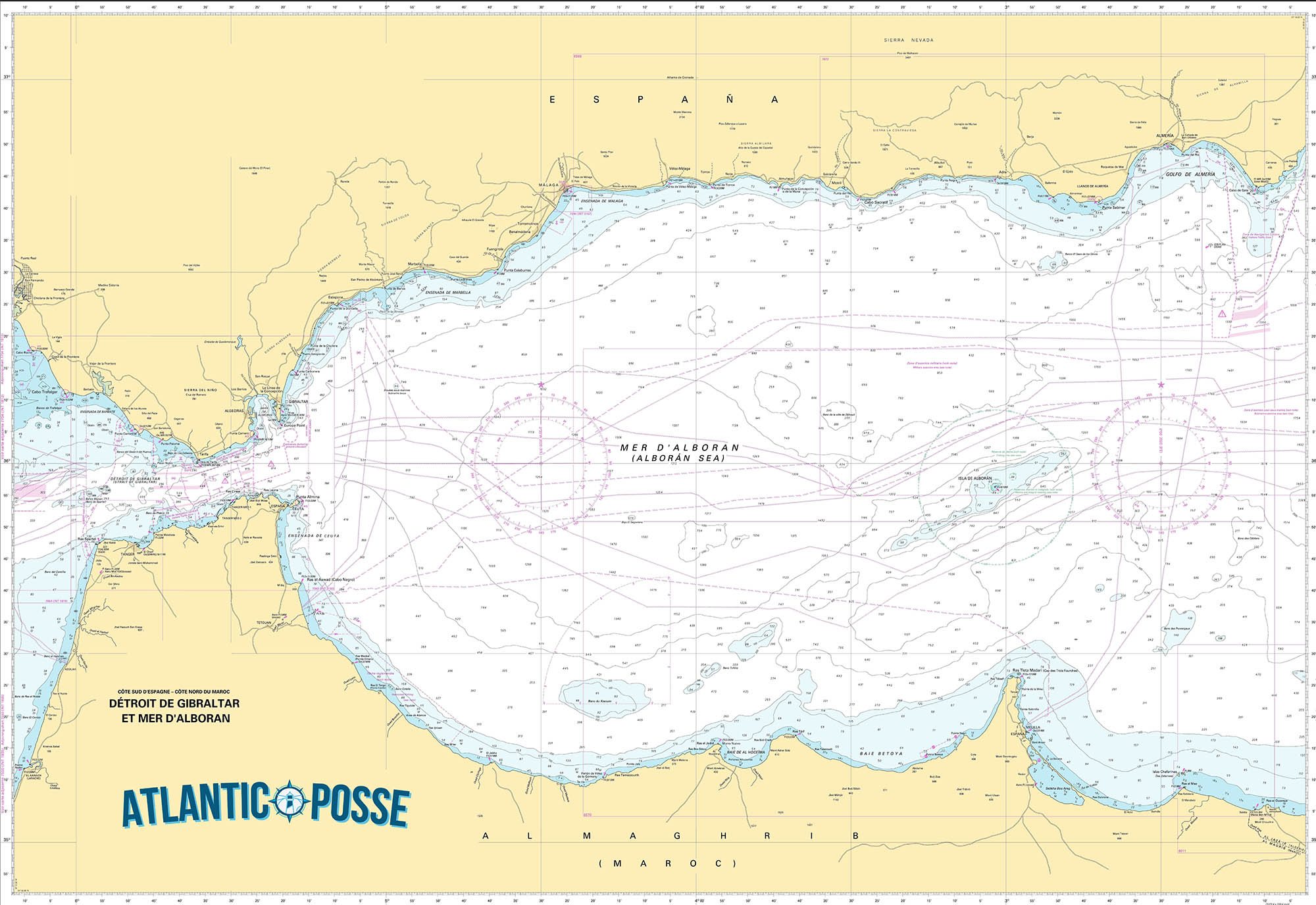
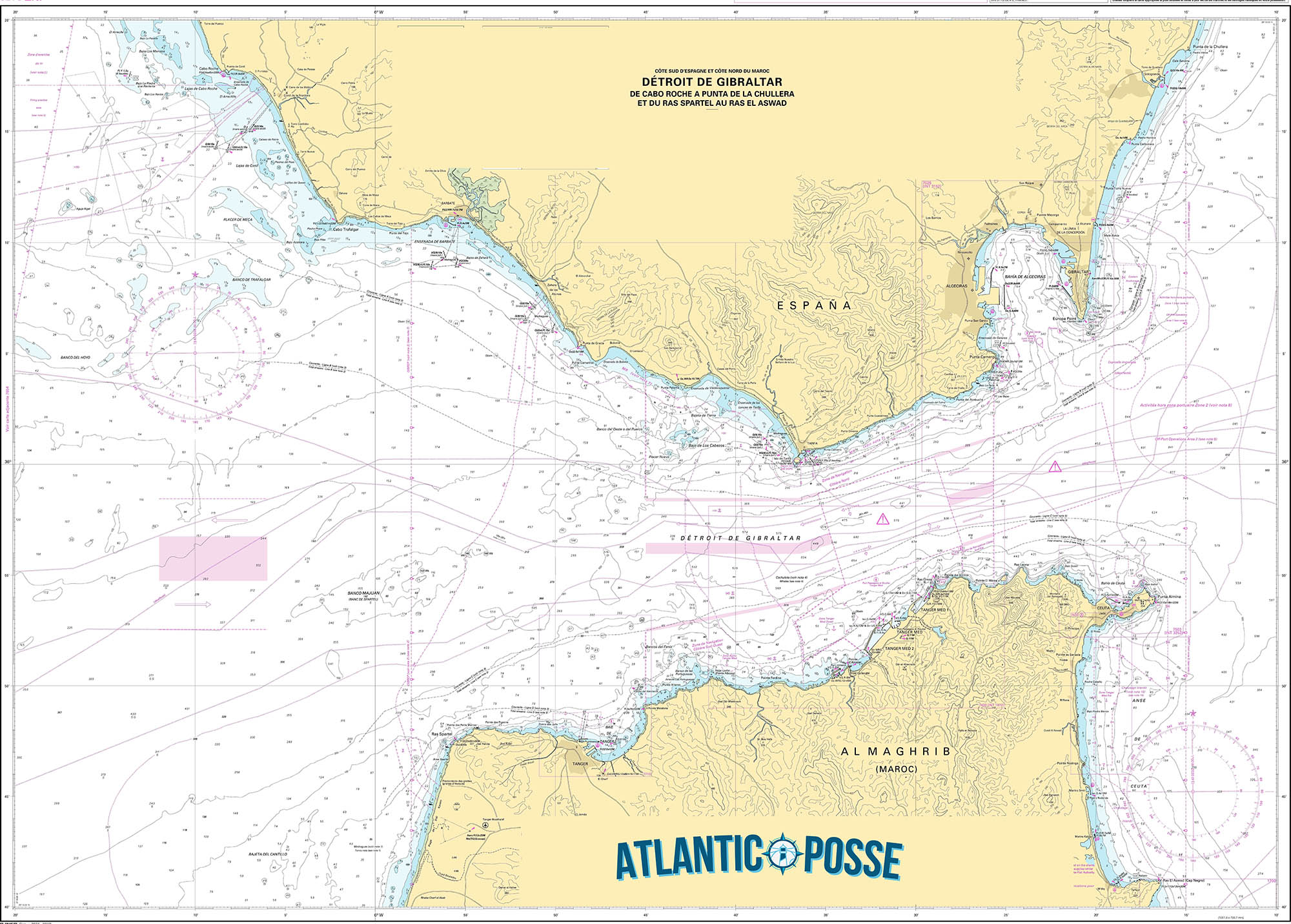
The Strait of Gibraltar, a narrow passage connecting the Atlantic Ocean to the Mediterranean Sea, has long been a crucial maritime route for sailors. Spanning approximately 36 miles (58 kilometers) and narrowing to about 8 miles (13 kilometers) at its most constricted point, the strait presents unique challenges and opportunities. Understanding the currents, wind patterns, and potential dangers is essential for a safe and successful passage.
Geographic and Historical Context
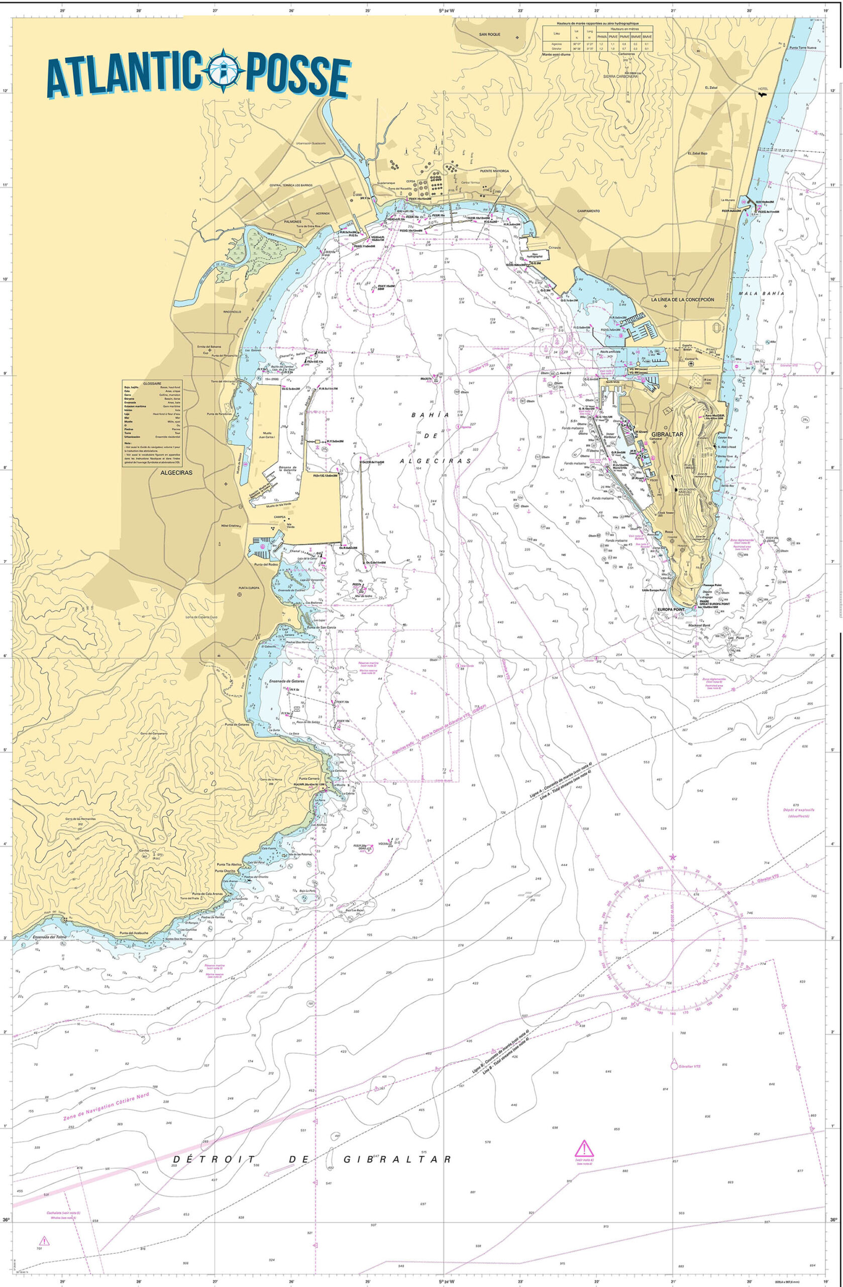
Gibraltar, a British Overseas Territory located on the southern coast of Spain, is dominated by the Rock of Gibraltar, a limestone promontory rising to 1,398 feet (426 meters). Historically, this area has been of immense strategic importance, serving as a gateway between the Mediterranean and Atlantic, and has seen numerous naval battles and trade routes passing through.
Wind and Weather Conditions
The wind conditions in the Strait of Gibraltar are influenced by both the Atlantic Ocean and the Mediterranean Sea, creating complex and often challenging scenarios for sailors.
- Levanter Wind: Originating from the east, the Levanter can bring moist, foggy conditions, reducing visibility and making navigation difficult. This wind is more prevalent during the summer months.
- Poniente Wind: Blowing from the west, the Poniente tends to be drier and can bring clear weather but strong gusts. It can be particularly challenging when entering the strait from the Atlantic.
- Local Wind Patterns: The interaction between these two major winds and the local topography can create microclimates and variable conditions within the strait itself.
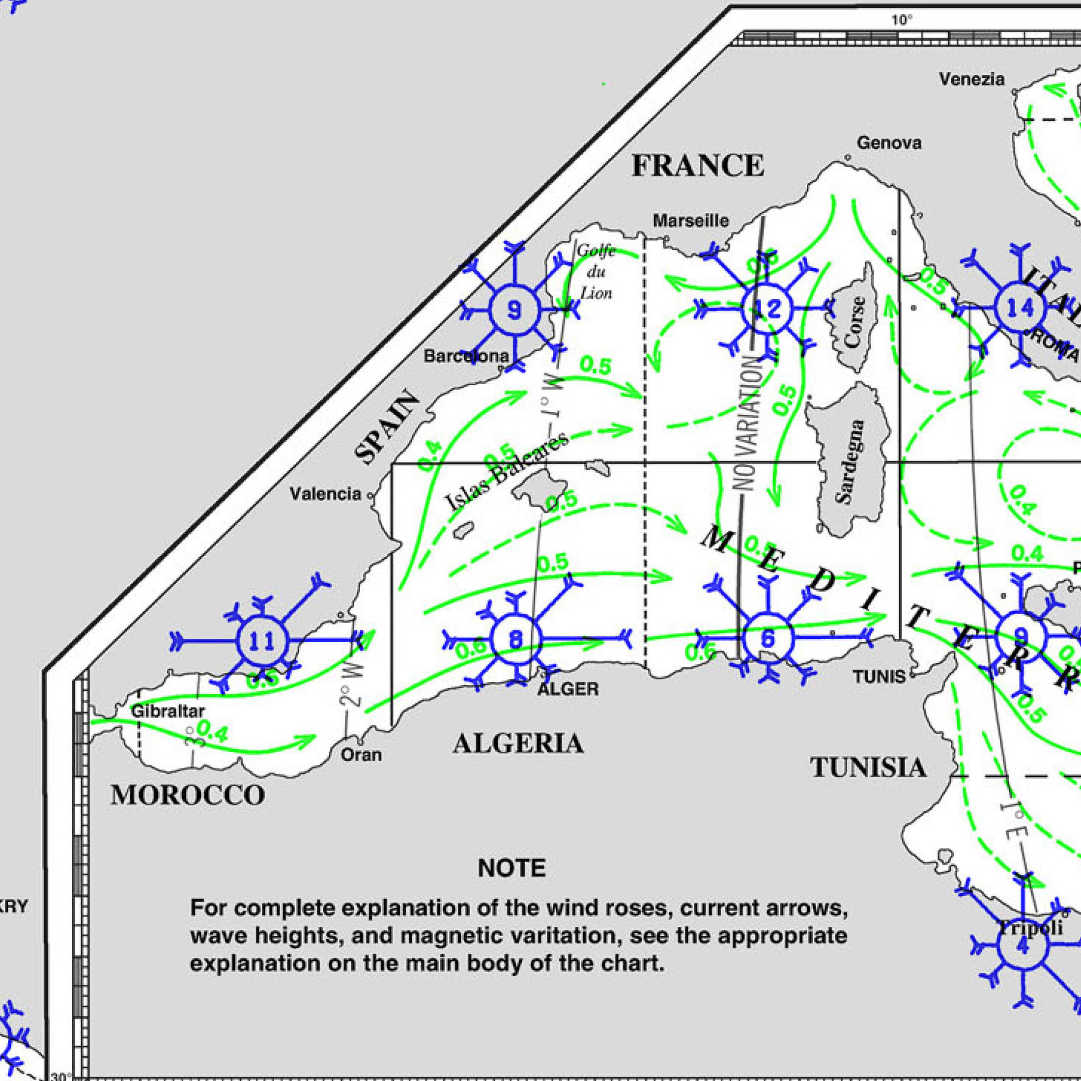
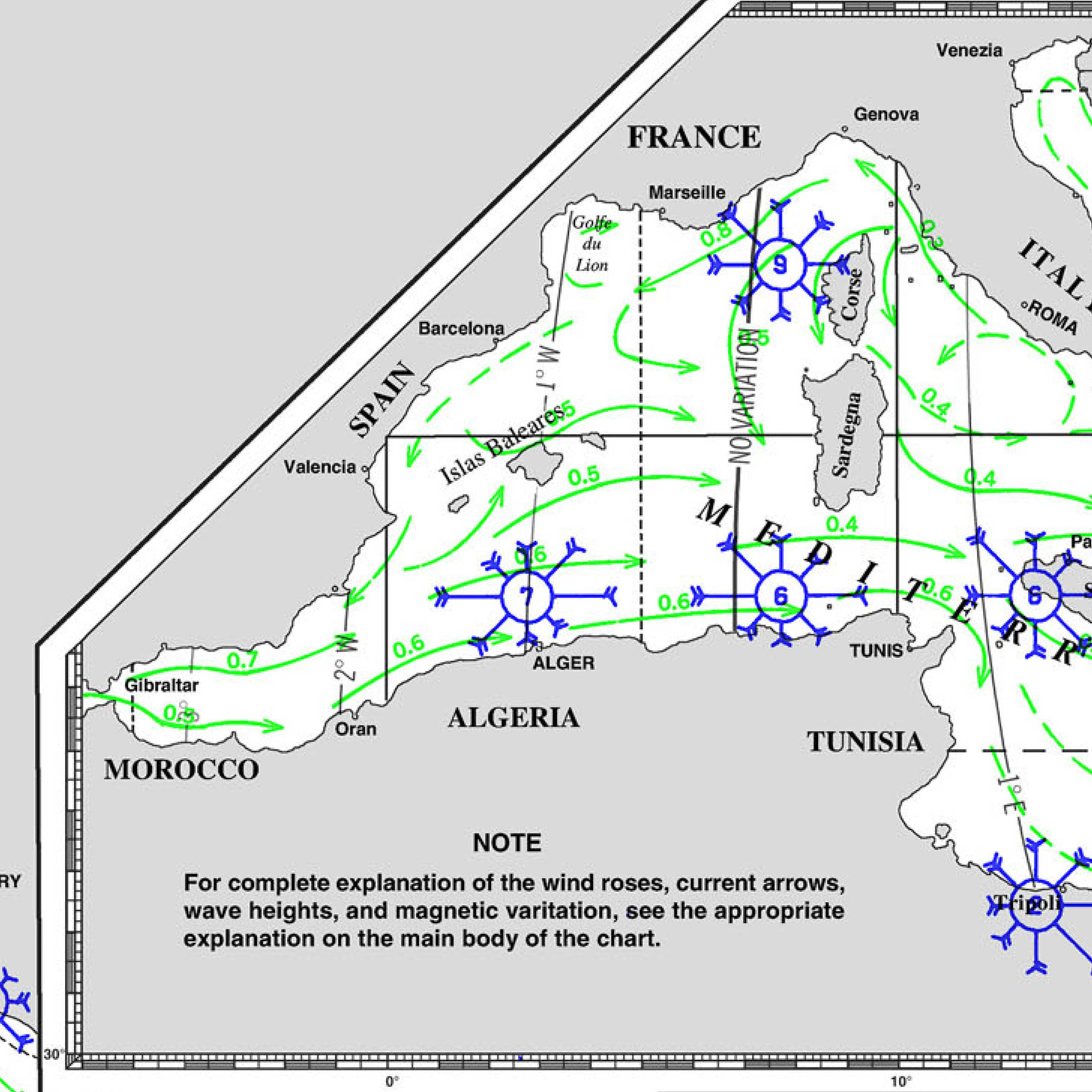
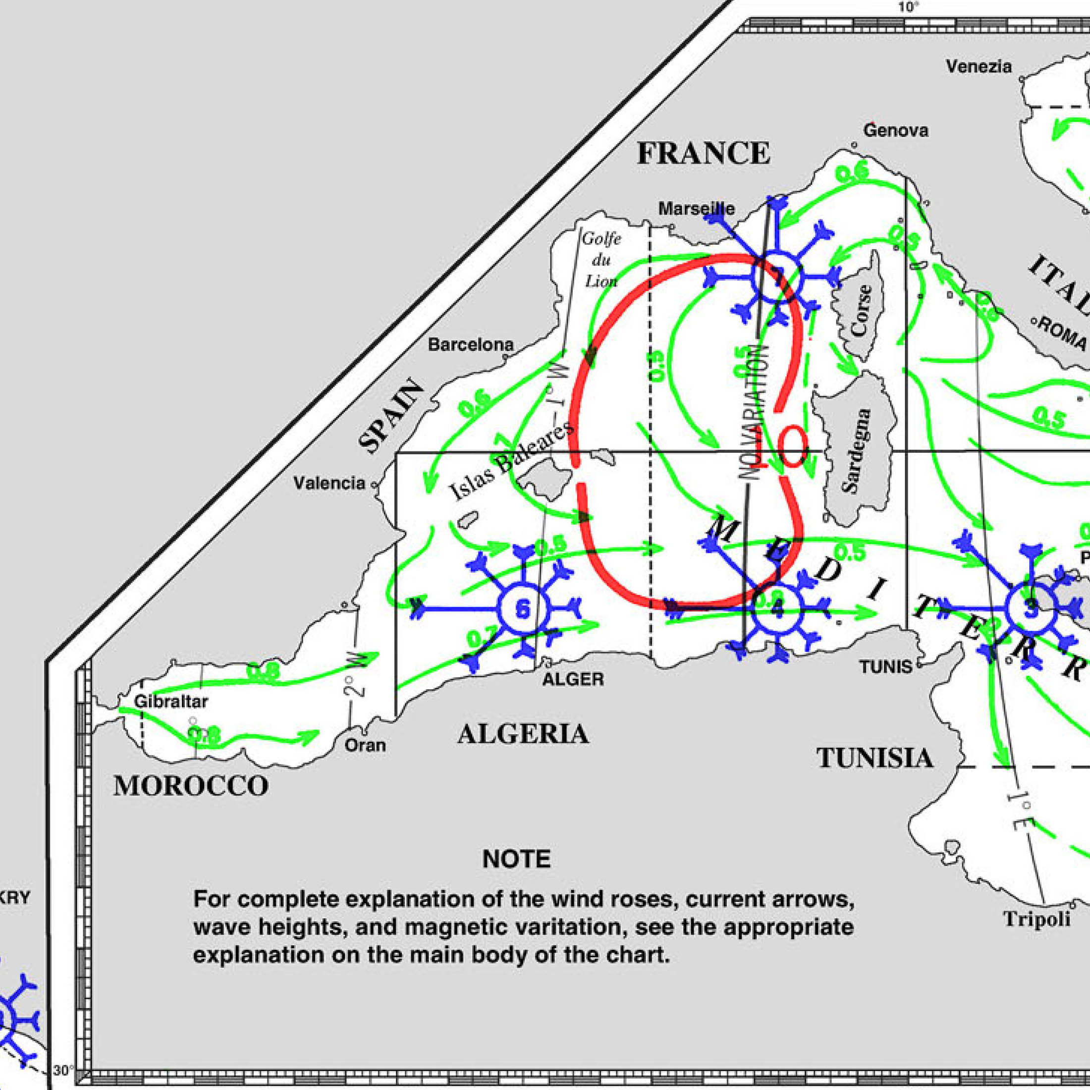
Currents and Tides
The currents in the Strait of Gibraltar are among the most critical factors to consider when planning a passage. These currents are primarily driven by the difference in salinity and water levels between the Atlantic Ocean and the Mediterranean Sea.
- Surface Currents: There is a prevailing eastward surface current entering the Mediterranean from the Atlantic, which can reach speeds of up to 4 knots. This current is strongest in the narrowest sections of the strait.
- Subsurface Currents: Below the surface, there is a westward counter-current that flows from the Mediterranean into the Atlantic. This current is slower but can affect deeper-draft vessels.
- Tidal Influence: The tides in the strait are semi-diurnal, with two high tides and two low tides each day. The tidal range is relatively small, but the tidal currents can be strong, particularly during spring tides.
Navigational Challenges and Dangers
- Traffic Density: The Strait of Gibraltar is one of the busiest maritime routes in the world, with a high density of commercial shipping, fishing vessels, and pleasure craft. Navigating through this traffic requires constant vigilance and adherence to traffic separation schemes.
- Navigational Hazards: The strait contains several significant hazards, including submerged rocks, sandbanks, and narrow passages. The Tarifa Narrows, near the town of Tarifa on the Spanish coast, is particularly treacherous.
- Weather Changes: Sudden changes in weather conditions, such as fog or squalls, can occur, reducing visibility and complicating navigation. Accurate weather forecasting and real-time monitoring are essential.
- Strong Currents and Eddies: The interaction of currents and tidal flows can create powerful eddies and turbulence, particularly near the entrance and exit of the strait. These can cause sudden and unpredictable changes in a vessel’s course and speed.
Entering the Strait from the Atlantic
When approaching the Strait of Gibraltar from the Atlantic, sailors must be prepared for the eastward surface current and the potential for strong westerly winds (Poniente). Here are key considerations for a safe passage:
- Timing the Entry: It is crucial to time the entry to coincide with favorable tidal conditions, ideally during slack water or the beginning of the flood tide to take advantage of the eastward current.
- Traffic Separation Scheme: Adherence to the established traffic separation scheme is essential to avoid conflicts with commercial vessels. Monitoring VHF channels for traffic updates and coordinating with traffic control is recommended.
- Navigating the Narrows: The Tarifa Narrows, where the strait is at its narrowest, requires careful navigation. Keeping a safe distance from the shore and submerged hazards is vital.
- Wind Conditions: Being aware of the local wind patterns and adjusting the sail plan accordingly can help manage the challenging conditions created by the Poniente wind.
Exiting the Strait into the Mediterranean
Sailing from the Strait of Gibraltar into the Mediterranean involves different challenges, primarily influenced by the prevailing eastward current and the potential for easterly winds (Levanter). Key considerations include:
- Current Management: Utilizing the eastward surface current can aid in a faster passage into the Mediterranean. However, sailors must be prepared for the subsurface counter-current, particularly if navigating deeper waters.
- Avoiding Congestion: The eastern exit of the strait can be congested with vessels converging from multiple directions. Maintaining situational awareness and clear communication with other vessels is essential.
- Weather Changes: The Levanter wind can bring fog and reduced visibility. Using radar and other navigational aids can help ensure a safe passage.
- Navigational Hazards: Several navigational hazards, including submerged rocks and shifting sandbanks, are present near the eastern exit. Consulting updated charts and sailing directions is recommended.
Local Facilities and Services
Both the Atlantic and Mediterranean sides of the Strait of Gibraltar offer facilities and services that can assist sailors in their passage.
- Ports and Marinas: Key ports such as Algeciras and Tarifa on the Spanish coast, and Gibraltar itself, offer docking facilities, fuel, provisions, and repair services.
- Pilotage Services: Pilotage is available and recommended for larger vessels or those unfamiliar with the strait. Local pilots have detailed knowledge of the currents, hazards, and traffic patterns.
- Communication: Maintaining regular communication with port authorities and traffic control can provide up-to-date information on conditions and potential hazards.
Environmental Considerations
The Strait of Gibraltar is an ecologically sensitive area, with a diverse range of marine life. Sailors should be aware of the environmental impact of their passage and take steps to minimize it.
- Marine Protected Areas: Certain areas within the strait are designated as marine protected areas, with restrictions on anchoring, fishing, and waste disposal. Familiarizing oneself with these regulations is important.
- Wildlife: The strait is a migration route for various marine species, including whales and dolphins. Reducing speed and maintaining a lookout for wildlife can help prevent collisions and disturbances.
- Pollution Prevention: Ensuring that all waste is properly disposed of and avoiding any discharge of pollutants into the water is crucial for protecting the marine environment.
Conclusion
Sailing into and out of the Strait of Gibraltar presents a unique set of challenges and opportunities. Understanding the complex interplay of currents, wind patterns, and navigational hazards is essential for a safe and successful passage. By careful planning, vigilance, and respect for the local environment, sailors can navigate this historic and strategic waterway with confidence.
Whether approaching from the Atlantic or exiting into the Mediterranean, the strait requires a combination of traditional seamanship and modern navigational aids. With its rich history and vital importance to global maritime traffic, the Strait of Gibraltar remains a key destination for sailors worldwide.
Marinas in Gibraltar
Gibraltar, a prominent British Overseas Territory located on the southern coast of the Iberian Peninsula, is renowned not only for its strategic significance but also for its excellent maritime facilities. The following are some of the key marinas in Gibraltar, each offering a range of services and amenities for sailors and yachts:
1. Ocean Village Marina
Coordinates: 36°08.6’N, 05°21.2’W
Description: Ocean Village Marina is one of the premier marinas in Gibraltar, known for its modern facilities and vibrant atmosphere. Located adjacent to the Ocean Village development, it offers a range of amenities including luxury apartments, restaurants, bars, and shops.
Features:
- 24-hour security and surveillance
- High-speed Wi-Fi
- Power and water supply at each berth
- Fuel station
- Modern shower and toilet facilities
- On-site maintenance and repair services
- Yacht brokerage and charter services
Activities: Ocean Village Marina is also a hub for social and leisure activities, with various events and entertainment options available throughout the year.
2. Queensway Quay Marina
Coordinates: 36°08.7’N, 05°21.3’W
Description: Queensway Quay Marina offers a tranquil and picturesque setting, making it a popular choice for those seeking a more relaxed atmosphere. It is located within walking distance of Gibraltar’s city center, providing easy access to local attractions and services.
Features:
- Secure berthing facilities with 24-hour surveillance
- Power and water supply at each berth
- High-speed Wi-Fi
- Modern shower and toilet facilities
- Fuel station nearby
- On-site maintenance and repair services
- Laundry facilities
- Selection of waterfront restaurants and cafes
Activities: The marina is an excellent base for exploring Gibraltar’s rich history and natural beauty, with the Rock of Gibraltar and other landmarks easily accessible.
3. Marina Bay
Coordinates: 36°08.6’N, 05°21.1’W
Description: Marina Bay is another top-tier marina in Gibraltar, known for its comprehensive range of services and amenities. It is located next to Ocean Village Marina, providing additional berthing options and facilities for sailors.
Features:
- 24-hour security and CCTV
- Power and water supply at each berth
- High-speed Wi-Fi
- Modern shower and toilet facilities
- Fuel station
- On-site maintenance and repair services
- Yacht brokerage and charter services
- Selection of restaurants, bars, and shops nearby
Activities: Marina Bay is well-positioned for exploring Gibraltar’s attractions and offers a lively social scene with various events and activities throughout the year.
4. Mid Harbour Marina
Coordinates: 36°08.9’N, 05°21.6’W
Description: Mid Harbour Marina is one of the newer marinas in Gibraltar, offering extensive berthing facilities for larger vessels. It is located in the central part of the harbor, providing easy access to Gibraltar’s amenities and attractions.
Features:
- Secure berthing with 24-hour surveillance
- Power and water supply at each berth
- High-speed Wi-Fi
- Modern shower and toilet facilities
- Fuel station
- On-site maintenance and repair services
- Laundry facilities
Activities: The marina’s central location makes it a convenient starting point for exploring Gibraltar’s historical sites, shopping areas, and natural attractions.
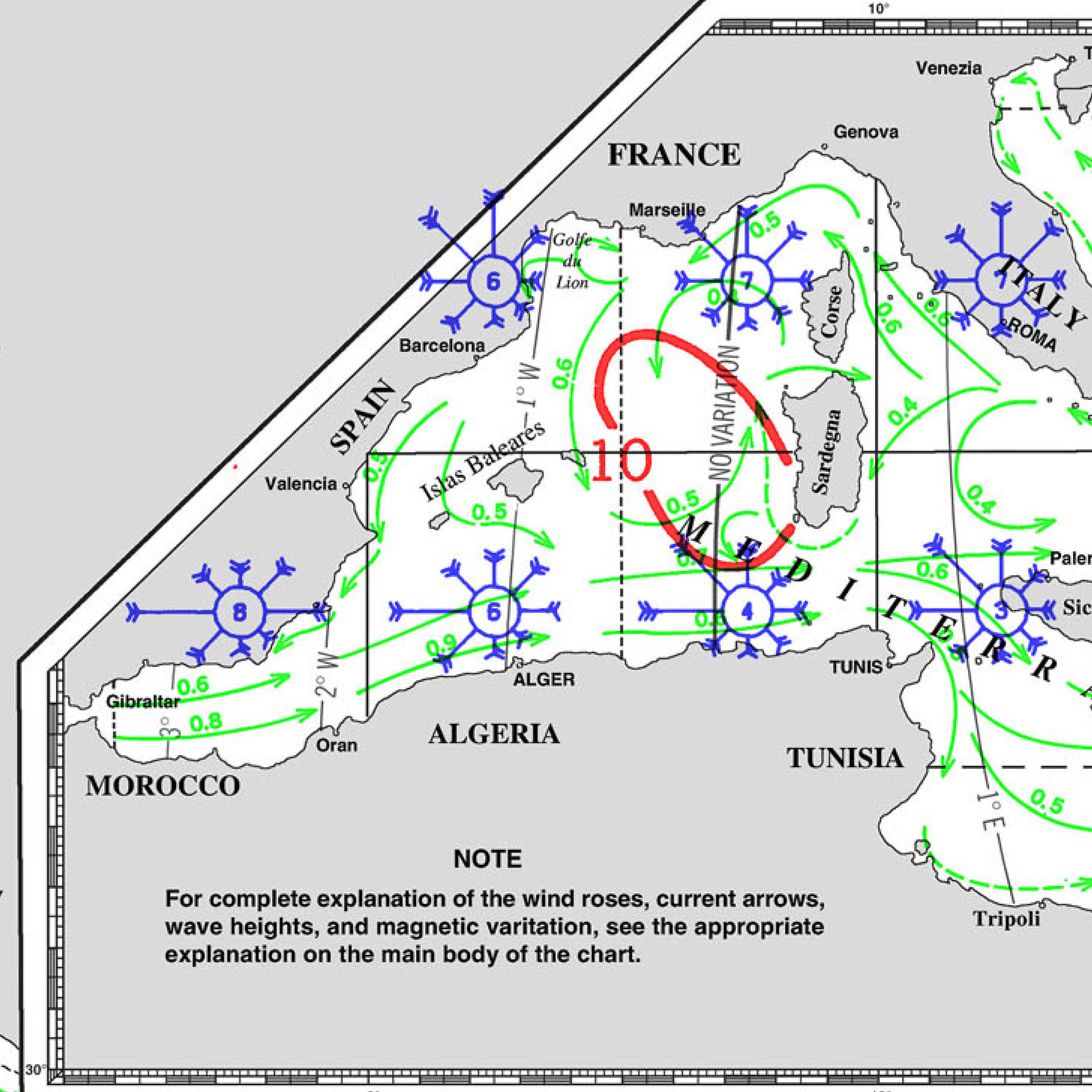
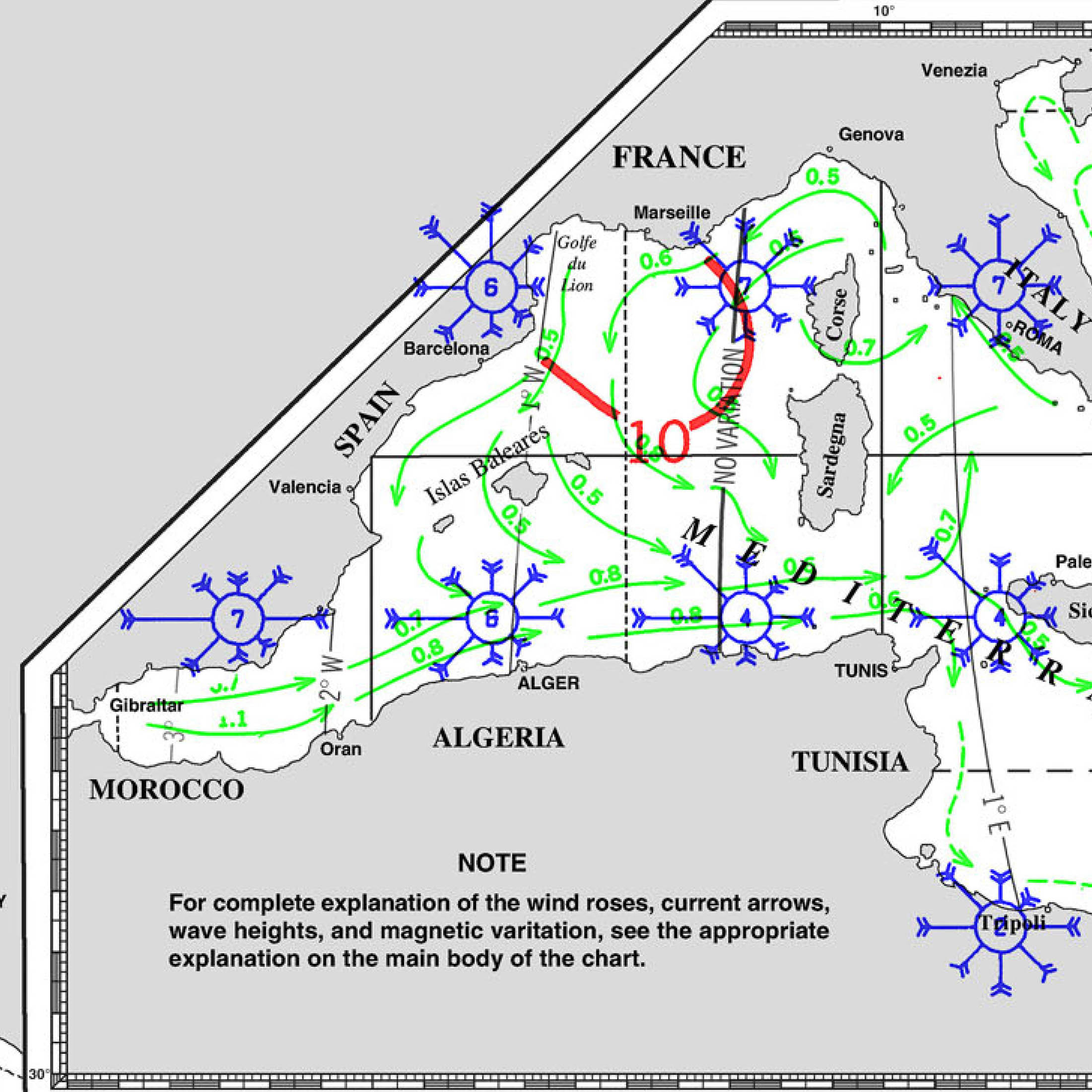
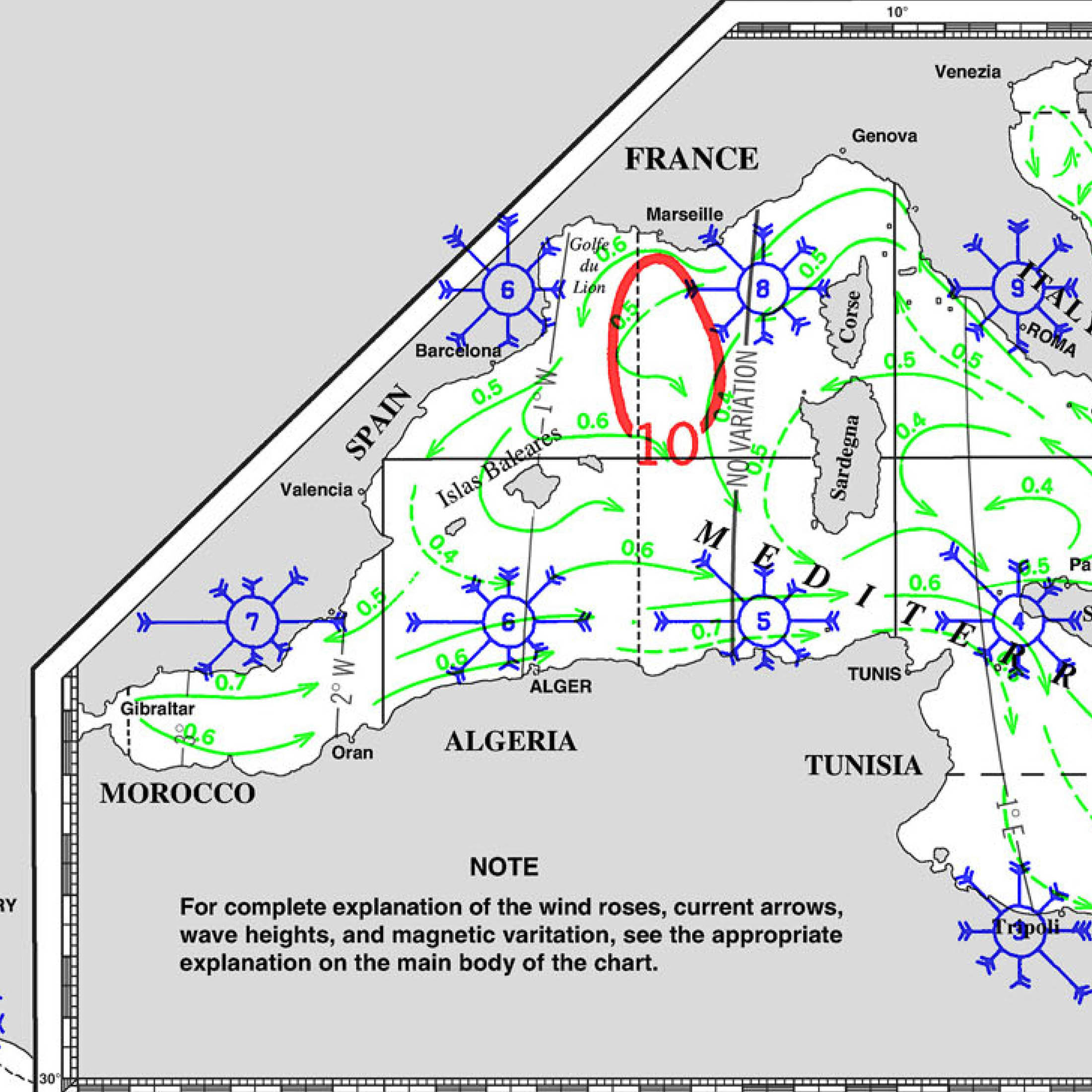
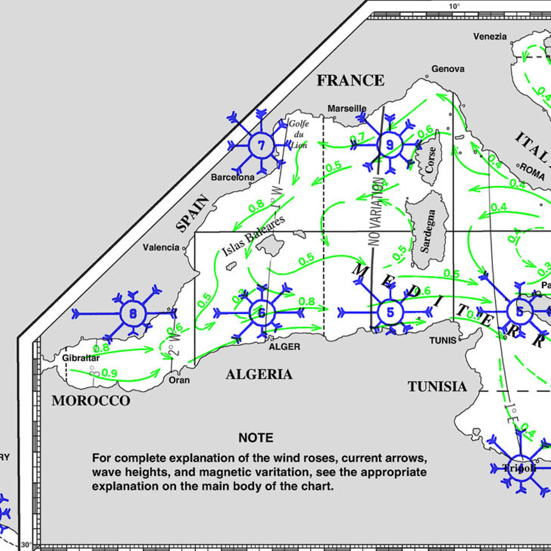
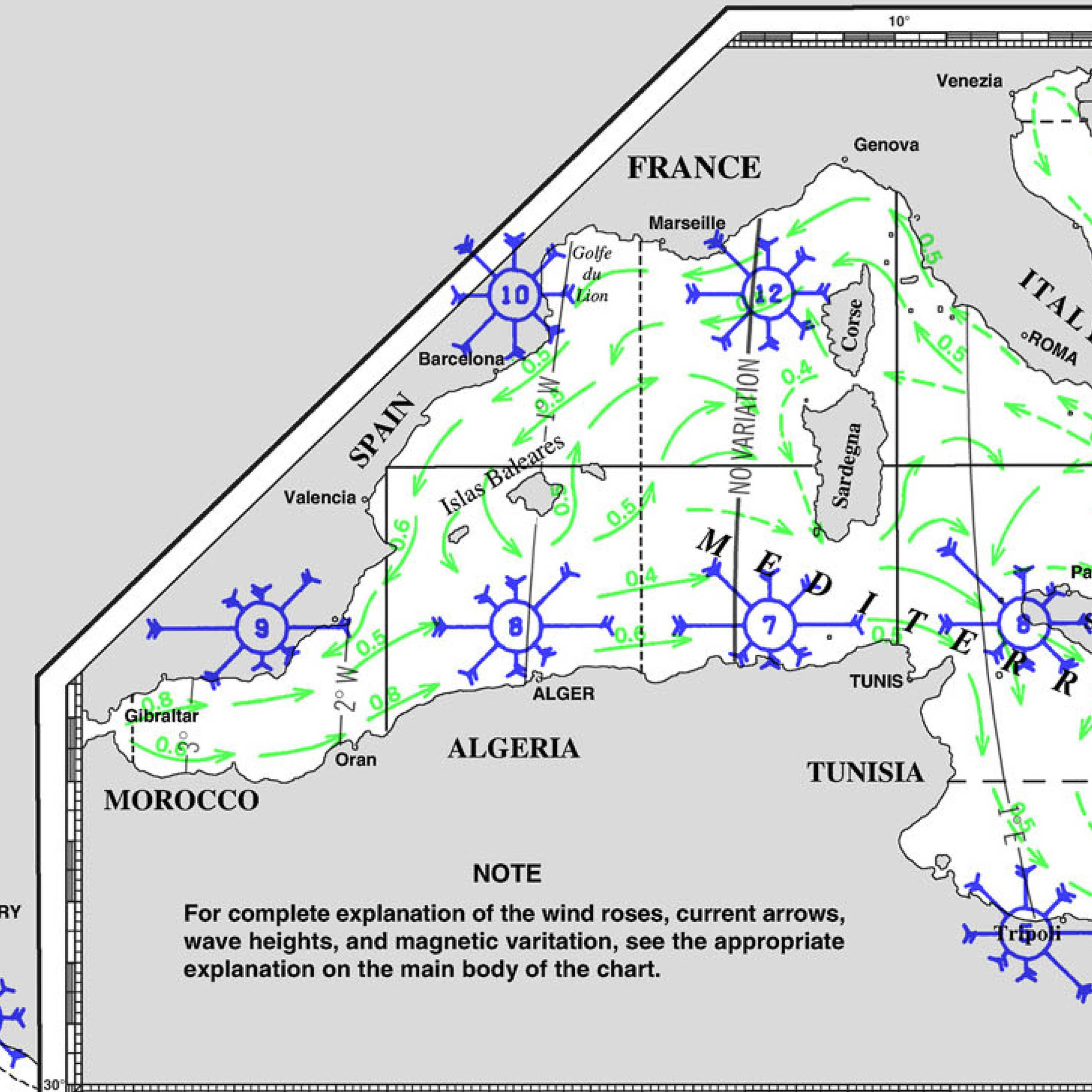
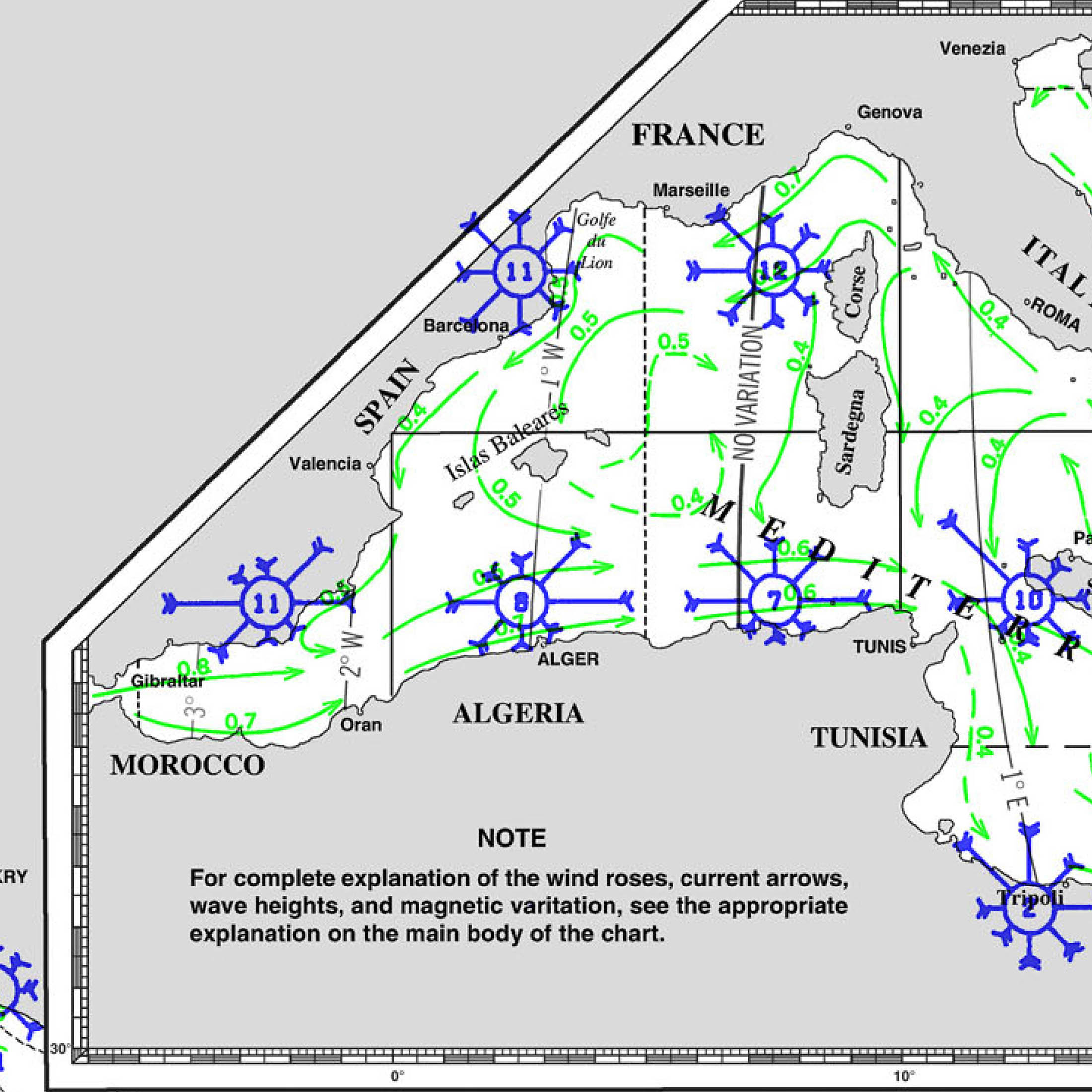
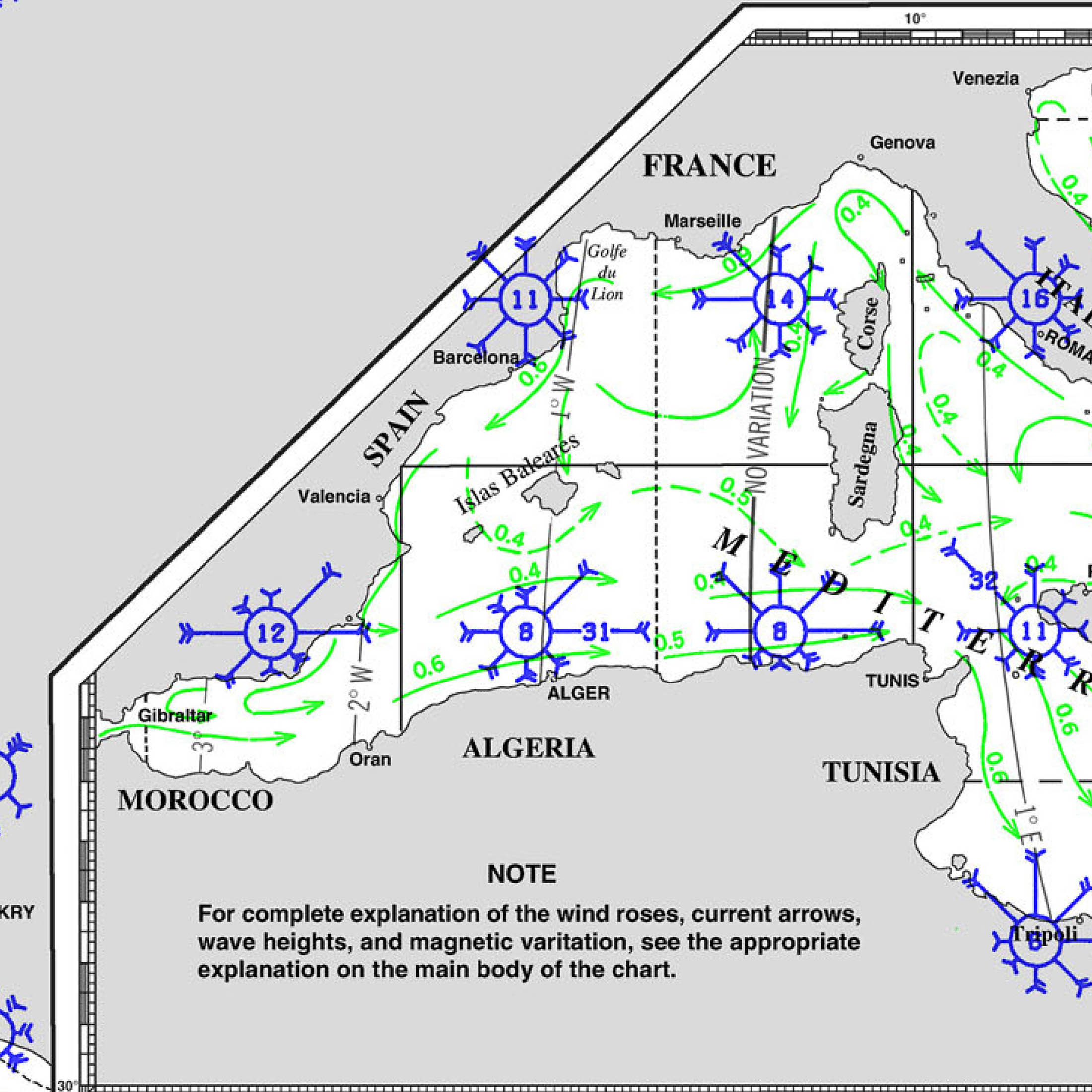
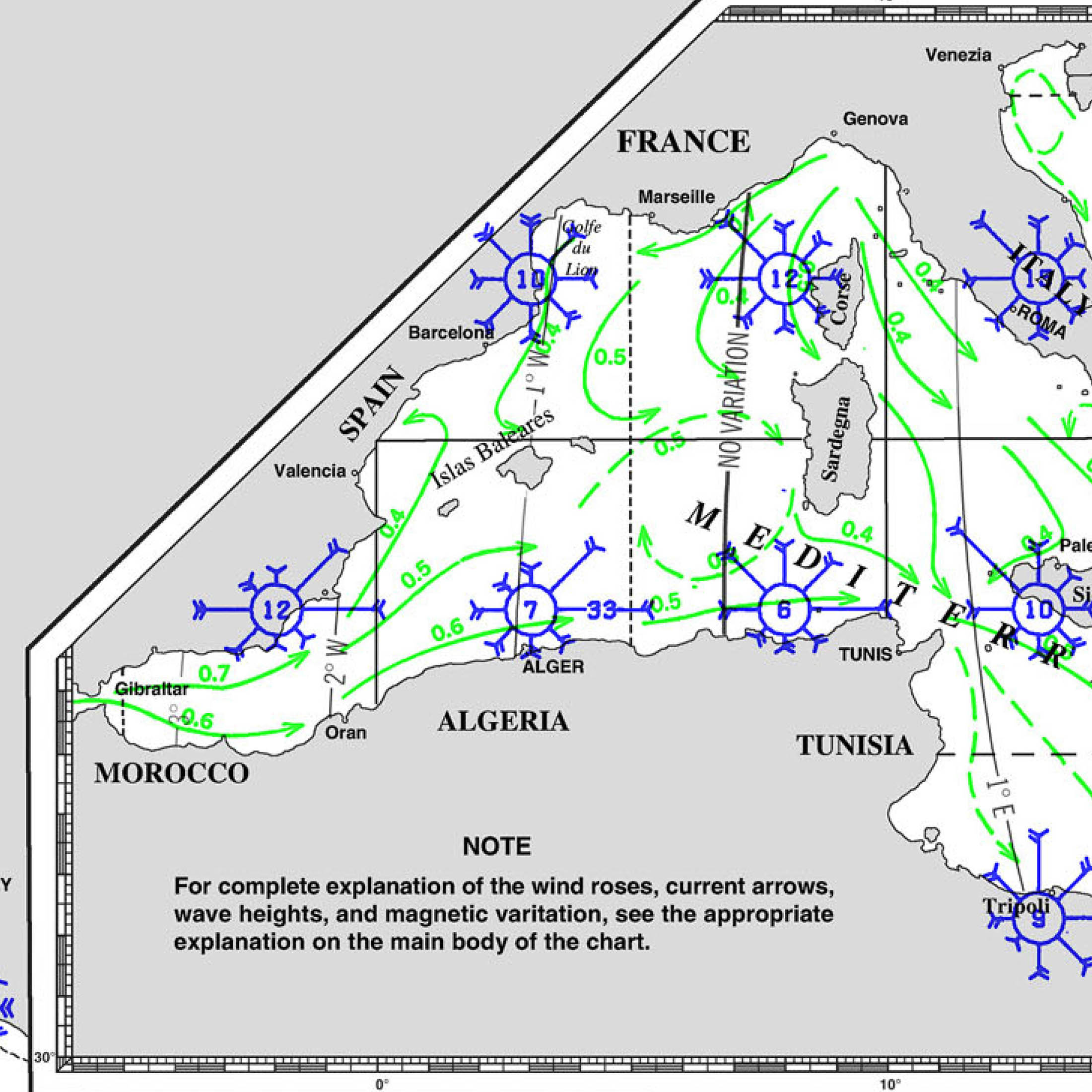
WEATHER
CURRENTS
SWELL AND WAVES
LOCAL WIND PHENOMENA
Wind Name Region Wind Direction Strength knts
Description Time of Year Levante Andalusia, Strait of Gibraltar East/Southeast 15-35
(Gusts up to 50)Warm, moist wind that can bring hot, humid weather and rough seas in the Strait. Mostly in Summer Poniente Andalusia, Southern Coast West 10-25
(Gusts up to 35)Dry, warm wind with lower humidity, often bringing cooler weather compared to Levante. All year, common in Summer and Autumn Sirocco (Jaloque) Mediterranean Coast, Balearic Islands South/Southeast 10-25
(Gusts up to 40)Hot, dry wind from the Sahara, bringing dust, sand, and hazy conditions. Mostly in Spring and Autumn
MAIN LOCAL WEATHER WEBSITE GIBRALTAR
https://www.metoffice.gov.uk/weather/forecast/eykjqrrw2
SEVERE WEATHER GIBRALTAR
PILOT CHARTS GIBRALTAR CLIMATOLOGY

DOCUMENTS
PORT OF ENTRY GIBRALTAR
| Consumer Prices in Gibraltar are 34.96% lower than in New York, NY (without rent) | |
| Consumer Prices Including Rent in Gibraltar are 39.73% lower than in New York, NY | |
| Rent Prices in Gibraltar are 44.79% lower than in New York, NY | |
| Restaurant Prices in Gibraltar are 29.44% lower than in New York, NY | |
| Groceries Prices in Gibraltar are 46.84% lower than in New York, NY | |
| Local Purchasing Power in Gibraltar is 16.92% lower than in New York, NY |
MUST SEE
Gibraltar is rich in history, culture, and natural beauty. Here are the top 12 must-see destinations for sailors, complete with coordinates:
1. The Rock of Gibraltar
Coordinates: 36°08.7’N, 05°20.6’W The iconic limestone promontory offers stunning views of the Mediterranean and Atlantic. The Rock is home to the famous Barbary macaques.
2. St. Michael’s Cave
Coordinates: 36°08.8’N, 05°20.2’W A spectacular natural cave used since ancient times, featuring impressive stalactites and stalagmites. It’s also used as a concert hall.
3. The Great Siege Tunnels
Coordinates: 36°08.9’N, 05°20.6’W These tunnels were excavated during the Great Siege of Gibraltar in the late 18th century and offer a fascinating glimpse into military history.
4. Moorish Castle
Coordinates: 36°08.9’N, 05°21.0’W Dating back to the 8th century, the castle provides insight into Gibraltar’s Islamic past and offers great views over the town.
5. Europa Point
Coordinates: 36°06.6’N, 05°20.6’W The southernmost point of Gibraltar, offering views of the African coast and home to the historic Trinity Lighthouse.
6. Alameda Botanical Gardens
Coordinates: 36°08.2’N, 05°21.3’W These beautiful gardens provide a tranquil escape with diverse plant species and shaded pathways.
7. Gibraltar Museum
Coordinates: 36°08.4’N, 05°21.2’W Offering extensive exhibits on Gibraltar’s history, from prehistoric times to the modern era, including the Great Siege.
8. Main Street
Coordinates: 36°08.4’N, 05°21.3’W Gibraltar’s bustling shopping street, where you can find duty-free shops, cafes, and local goods.
9. Casemates Square
Coordinates: 36°08.6’N, 05°21.1’W A lively square at the entrance to Main Street, perfect for dining, shopping, and people-watching.
10. Apes’ Den
Coordinates: 36°08.7’N, 05°20.5’W Home to Gibraltar’s famous Barbary macaques, the only wild monkey population in Europe.
11. Mediterranean Steps
Coordinates: 36°08.5’N, 05°20.3’W A challenging but rewarding hike offering breathtaking views of the Mediterranean and the African coast.
12. Gorham’s Cave Complex
Coordinates: 36°07.0’N, 05°20.6’W A UNESCO World Heritage Site, these caves provide valuable insights into Neanderthal life and archaeology.
1. Port of Gibraltar
- Latitude: 36.1400
- Longitude: -5.3530
- Location: Gibraltar
- Description: The Port of Gibraltar is strategically located at the entrance to the Mediterranean Sea, making it one of the most important ports in the region. It serves as a critical refueling stop for vessels, offering comprehensive port services, including customs clearance, immigration services, and ship repairs. The port is equipped to handle a wide range of vessel types, including commercial ships, yachts, and cruise liners.
- Phone: +350 200 46254
- Website: Port of Gibraltar
- Email: info@gibraltarport.com
This port is the primary entry point for all maritime traffic entering Gibraltar and is equipped to handle the needs of both commercial and recreational vessels. The strategic location of Gibraltar makes its port one of the busiest and most well-known in the region.