

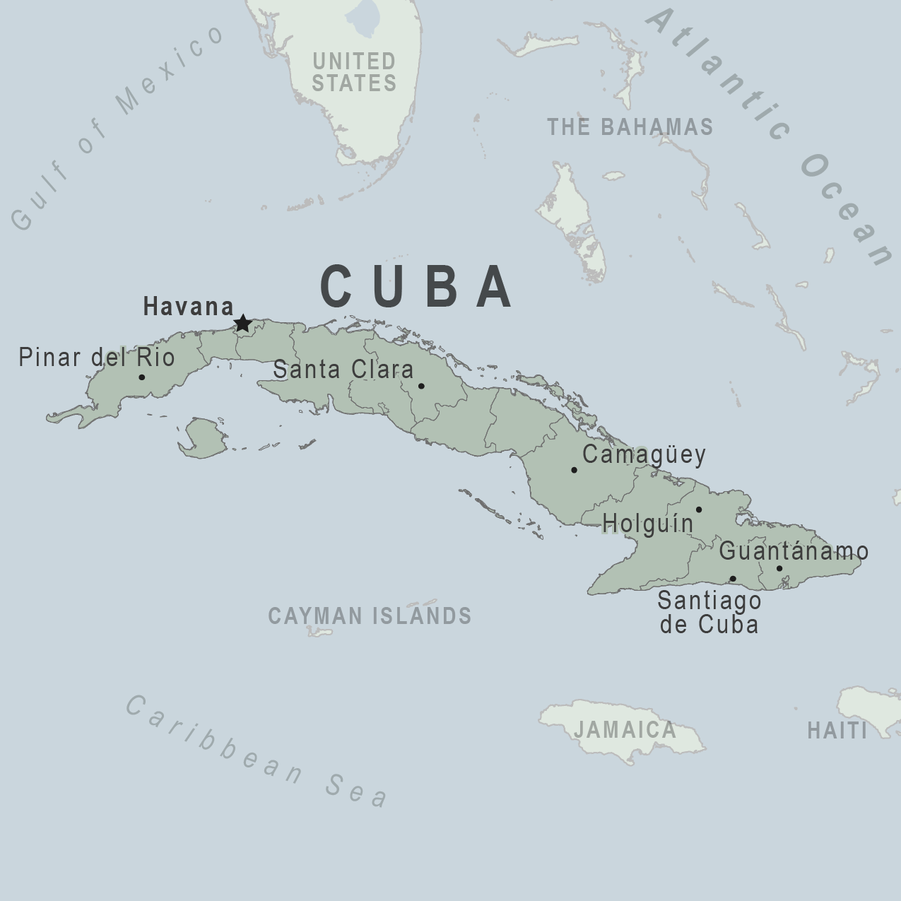
CUBA 🇨🇺 Cruising Cuba Ocean Posse
CUBA
🇨🇺 CUBA
4o
sponsoring MARINAS
Marinas in Western Cuba
- Marina Hemingway, Havana
- Coordinates: 23.0967° N, 82.4980° W
- Marina Dársena, Varadero
- Coordinates: 23.1885° N, 81.2437° W
- Marina Gaviota, Varadero
- Coordinates: 23.2029° N, 81.1284° W
- Marina Puertosol, Varadero
- Coordinates: 23.1553° N, 81.2476° W
Marinas in Western Cuba
- Marina Hemingway, Havana
- Coordinates: 23.0967° N, 82.4980° W
- Marina Dársena, Varadero
- Coordinates: 23.1885° N, 81.2437° W
- Marina Gaviota, Varadero
- Coordinates: 23.2029° N, 81.1284° W
- Marina Puertosol, Varadero
- Coordinates: 23.1553° N, 81.2476° W
Marinas in Central Cuba
- Marina Marlin Cienfuegos
- Coordinates: 22.1340° N, 80.4548° W
- Marina Trinidad
- Coordinates: 21.8016° N, 79.9832° W
- Marina Jardines del Rey, Cayo Coco
- Coordinates: 22.5238° N, 78.3890° W
- Marina Dársena de Cayo Guillermo
- Coordinates: 22.5777° N, 78.6653° W
- Marina Cayo Largo del Sur
- Coordinates: 21.6191° N, 81.5510° W
Marinas in Eastern Cuba
- Marina Santiago de Cuba
- Coordinates: 20.0221° N, 75.8069° W
- Marina Vita, Holguín
- Coordinates: 20.7477° N, 76.0304° W
- Marina Puerto de Vita
- Coordinates: 20.7478° N, 76.0274° W
- Marina Baracoa
- Coordinates: 20.3476° N, 74.5030° W
Other Notable Marinas
- Marina Tarará, Havana
- Coordinates: 23.1655° N, 82.1981° W
- Marina Cayo Guillermo
- Coordinates: 22.5874° N, 78.6689° W
- Marina Santiago de Cuba
- Coordinates: 20.0218° N, 75.8069° W
Central Cuba
- Marina Marlin Cienfuegos
- Coordinates: 22.1340° N, 80.4548° W
- Marina Trinidad
- Coordinates: 21.8016° N, 79.9832° W
- Marina Jardines del Rey, Cayo Coco
- Coordinates: 22.5238° N, 78.3890° W
- Marina Dársena de Cayo Guillermo
- Coordinates: 22.5777° N, 78.6653° W
- Marina Cayo Largo del Sur
- Coordinates: 21.6191° N, 81.5510° W
Eastern Cuba
- Marina Santiago de Cuba
- Coordinates: 20.0221° N, 75.8069° W
- Marina Vita, Holguín
- Coordinates: 20.7477° N, 76.0304° W
- Marina Puerto de Vita
- Coordinates: 20.7478° N, 76.0274° W
- Marina Baracoa
- Coordinates: 20.3476° N, 74.5030° W
Other Notable Marinas
- Marina Tarará, Havana
- Coordinates: 23.1655° N, 82.1981° W
- Marina Cayo Guillermo
- Coordinates: 22.5874° N, 78.6689° W
- Marina Santiago de Cuba
- Coordinates: 20.0218° N, 75.8069° W
WEATHER
Swell
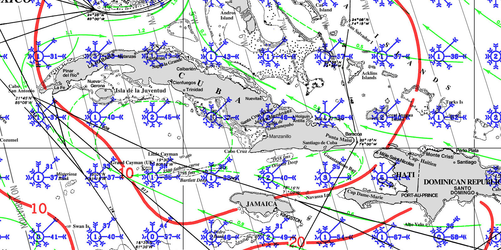
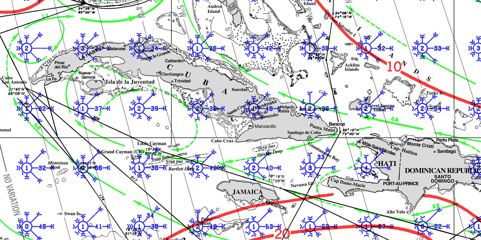
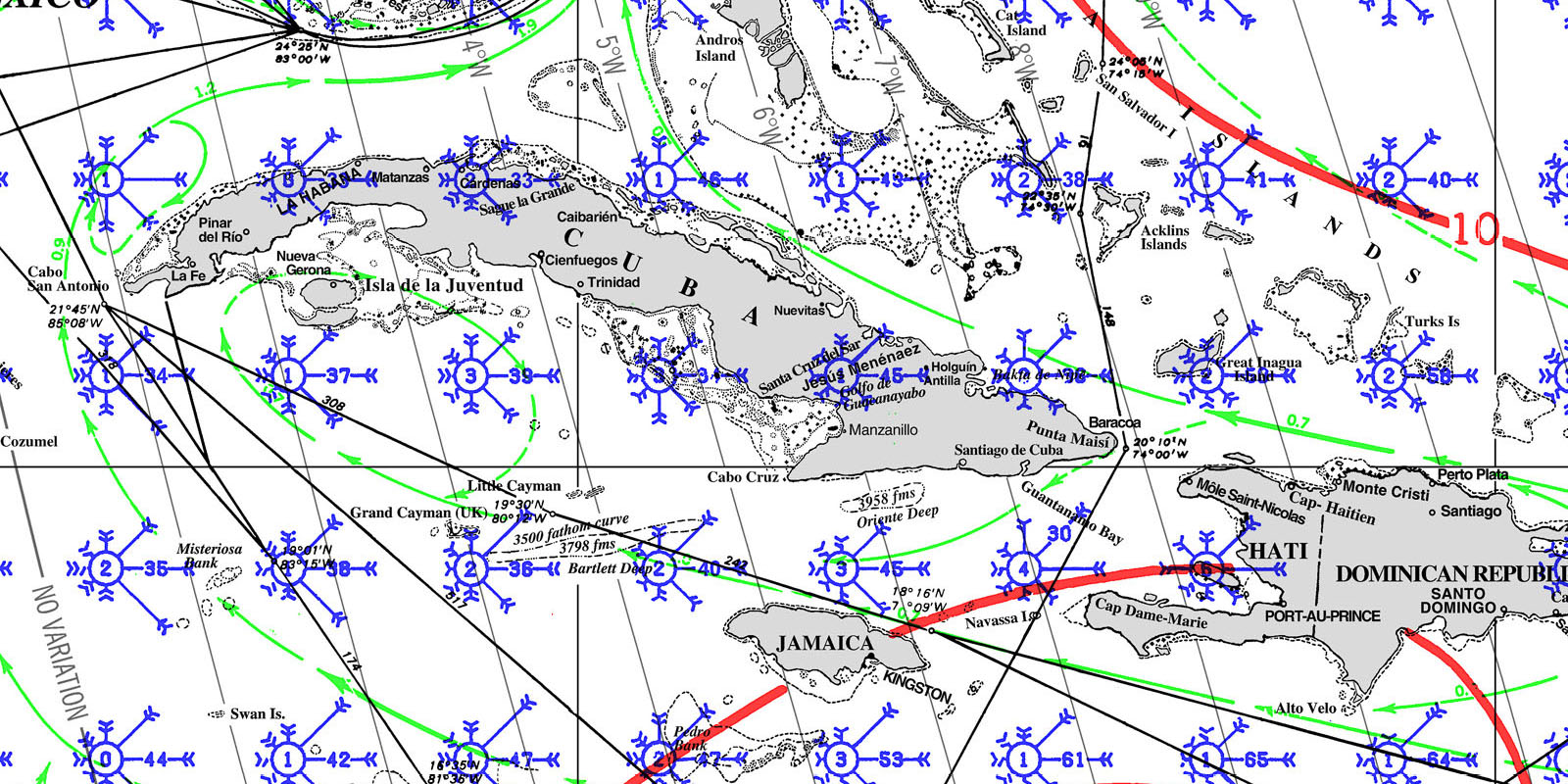
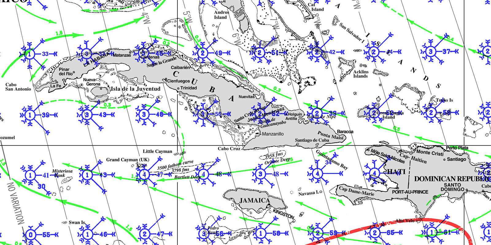
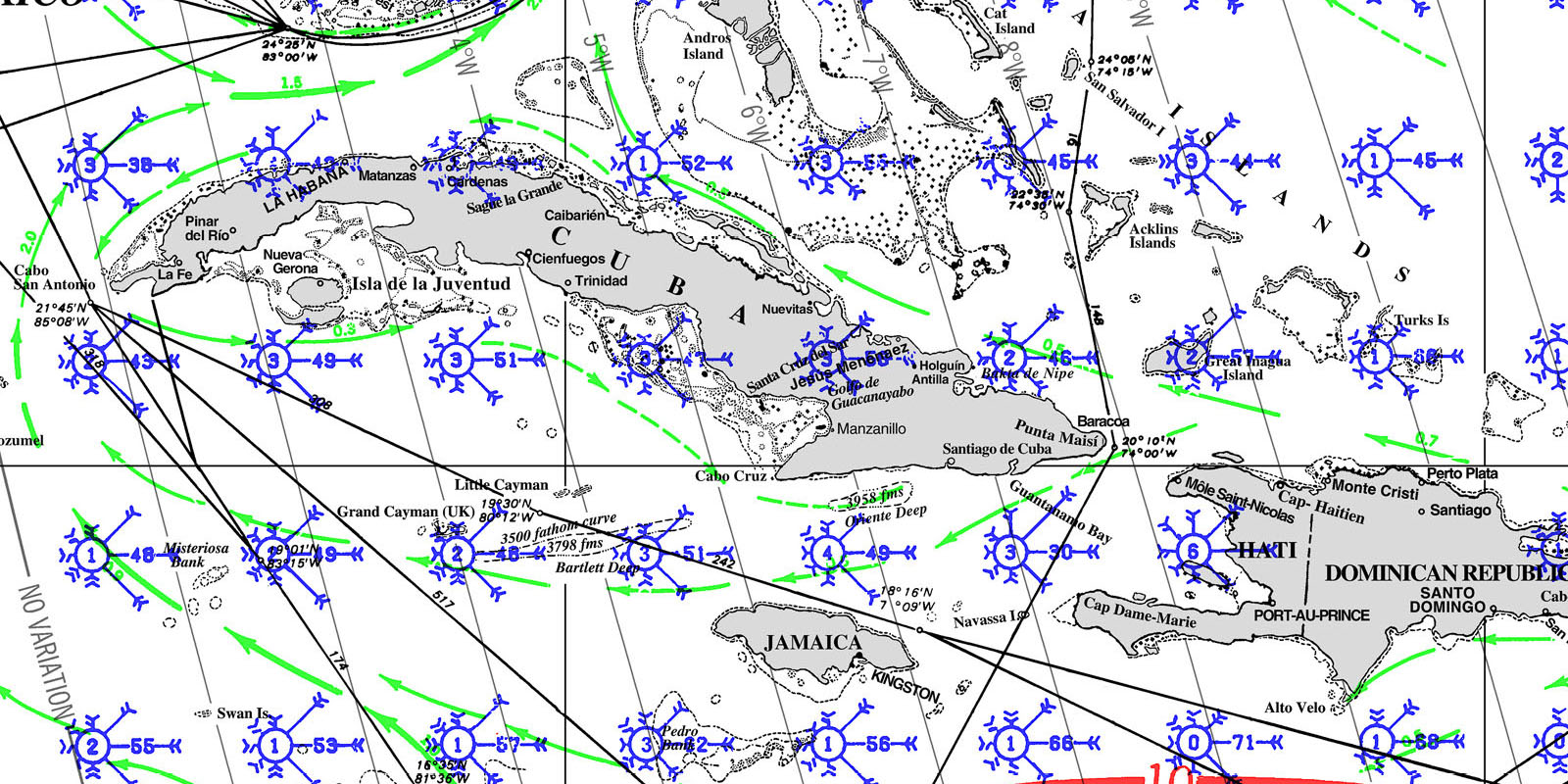
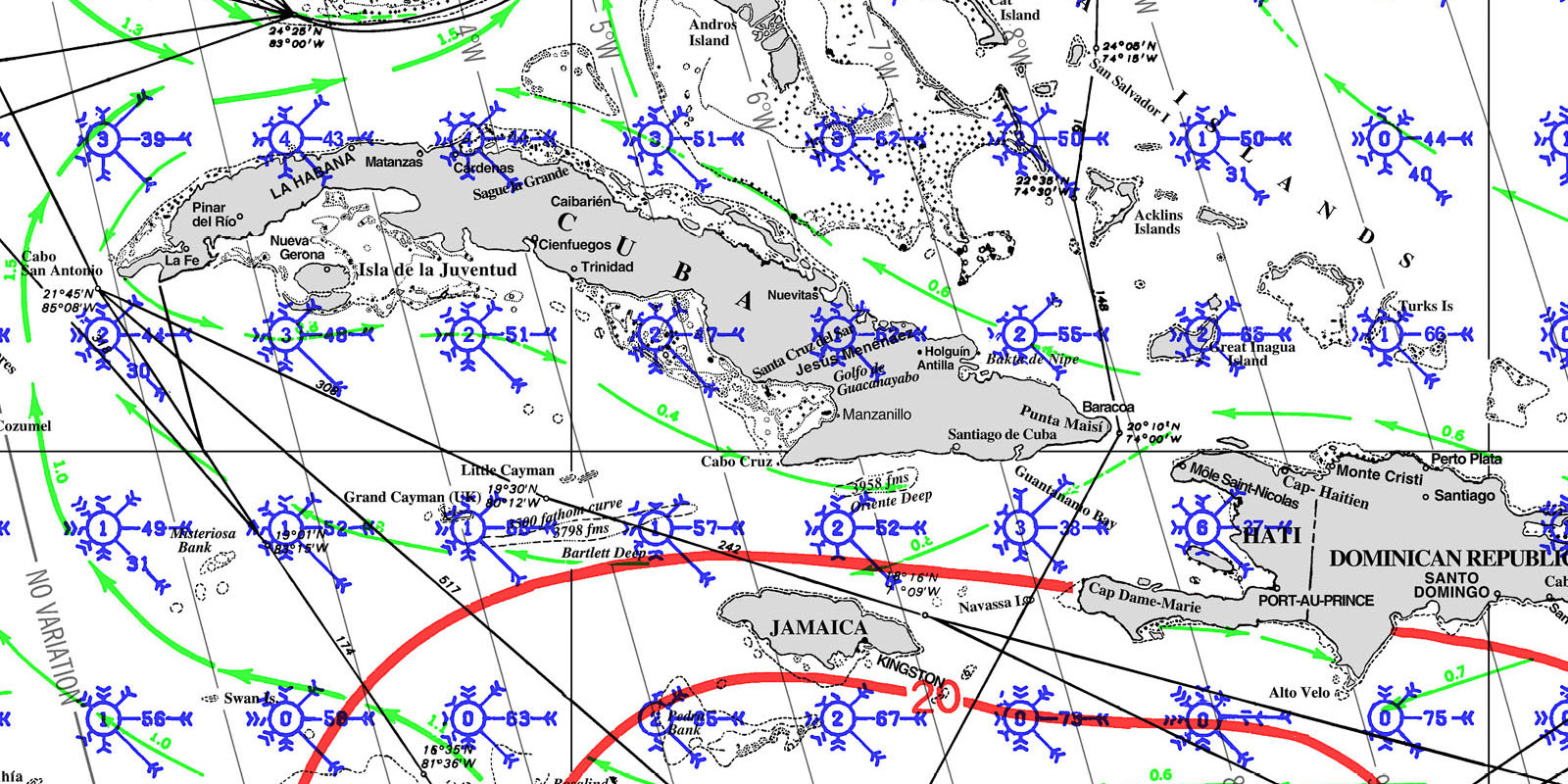
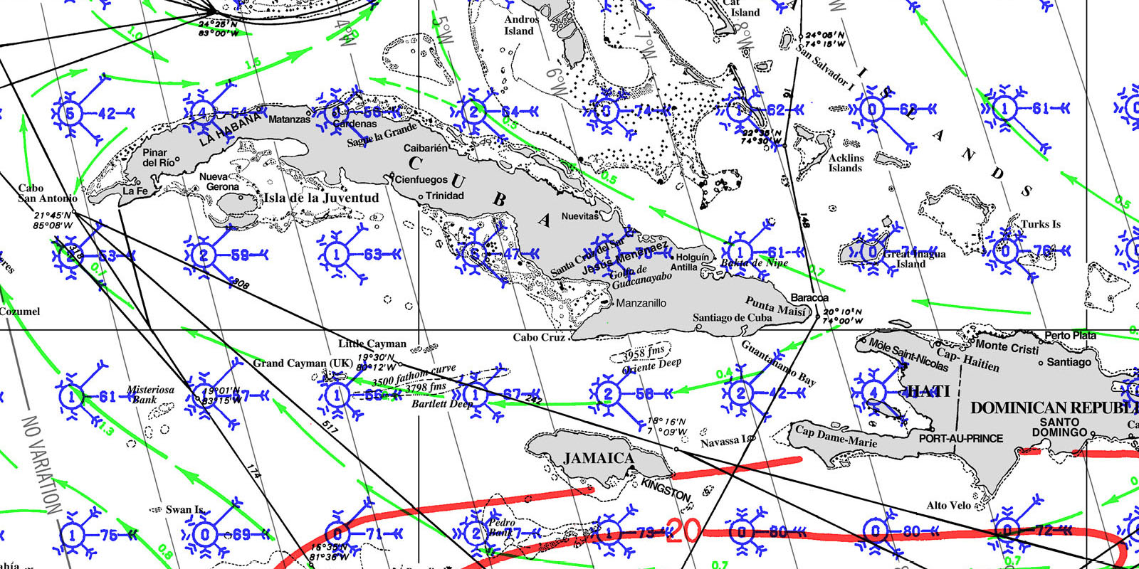
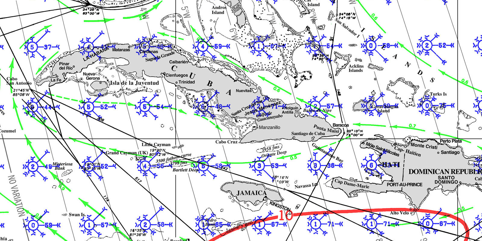
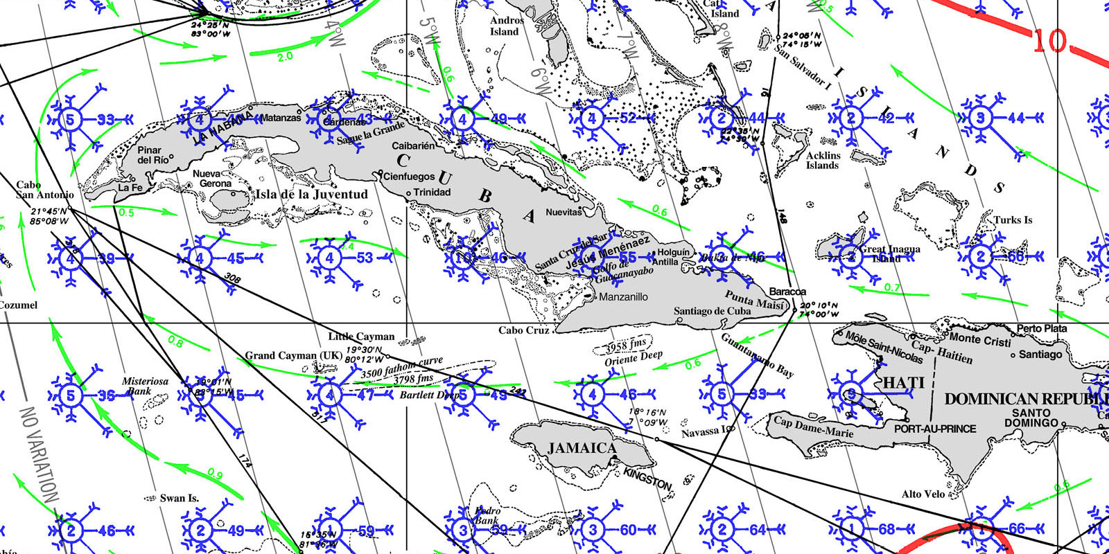
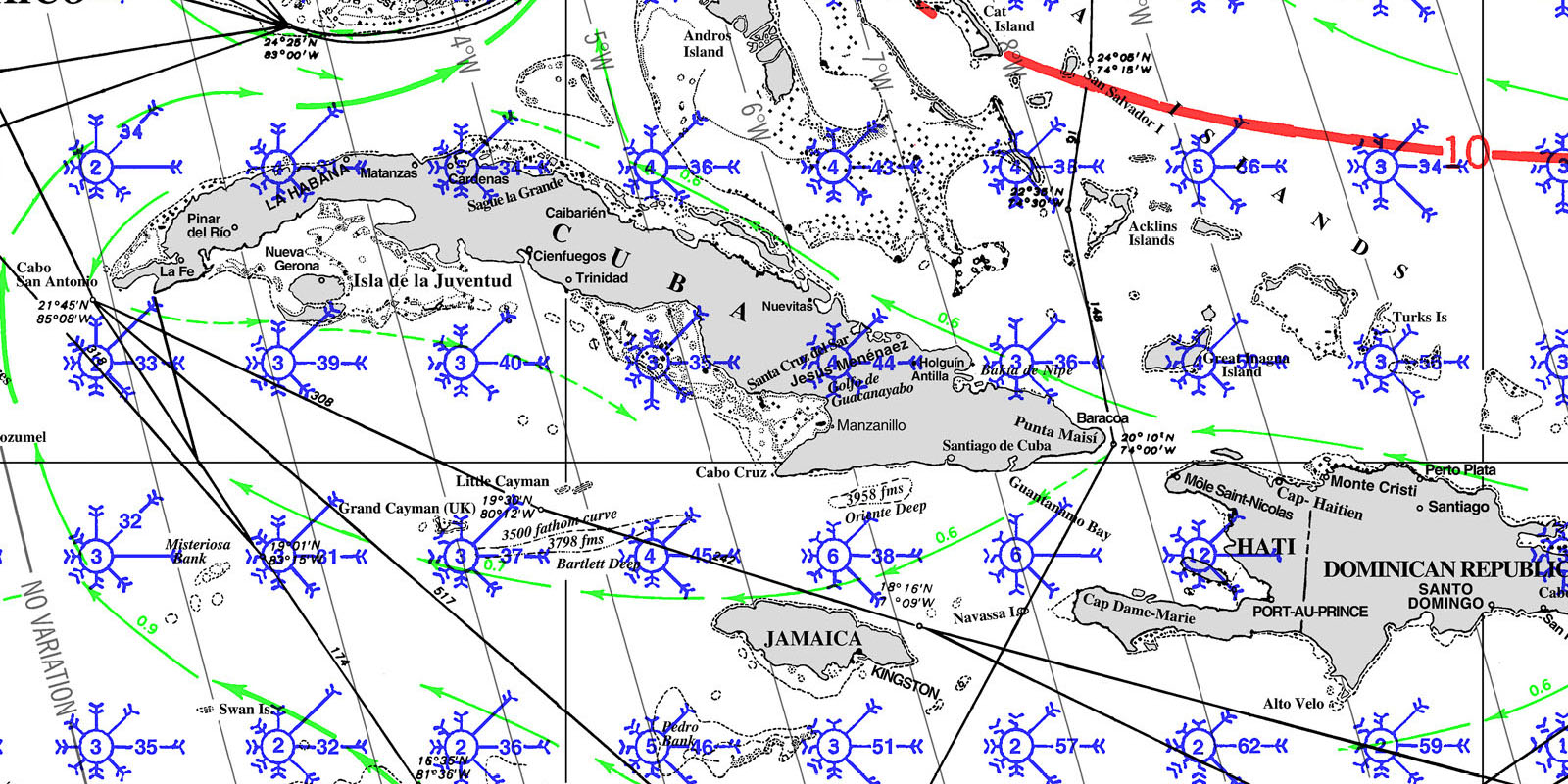
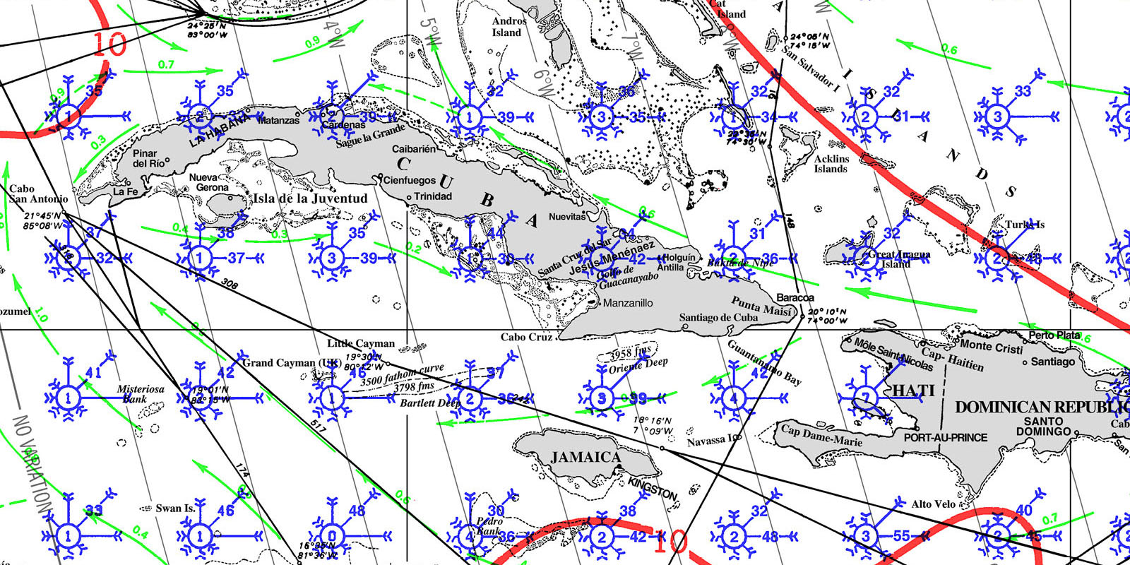
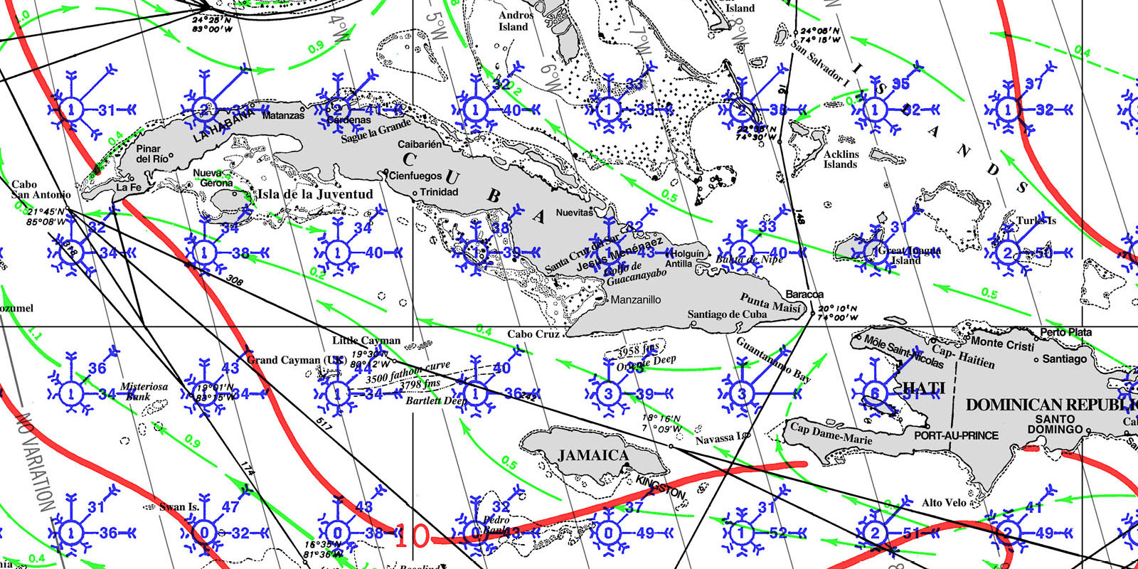
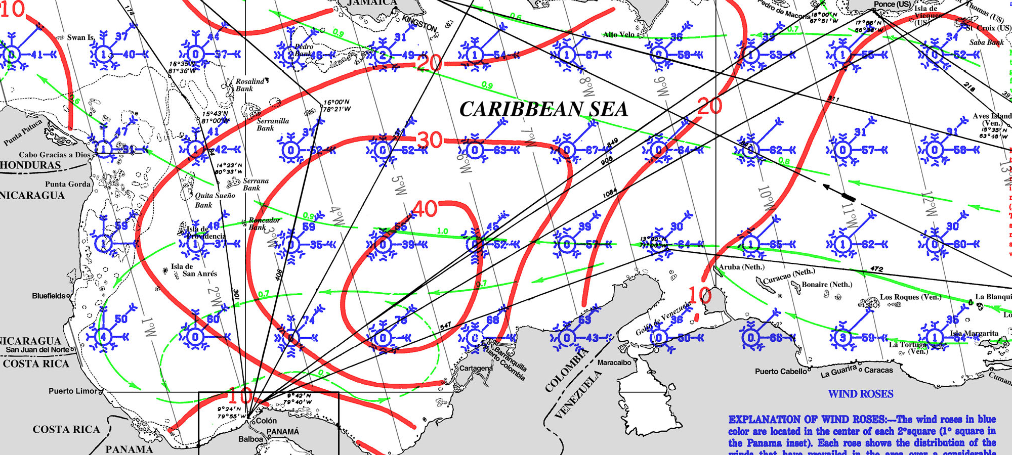
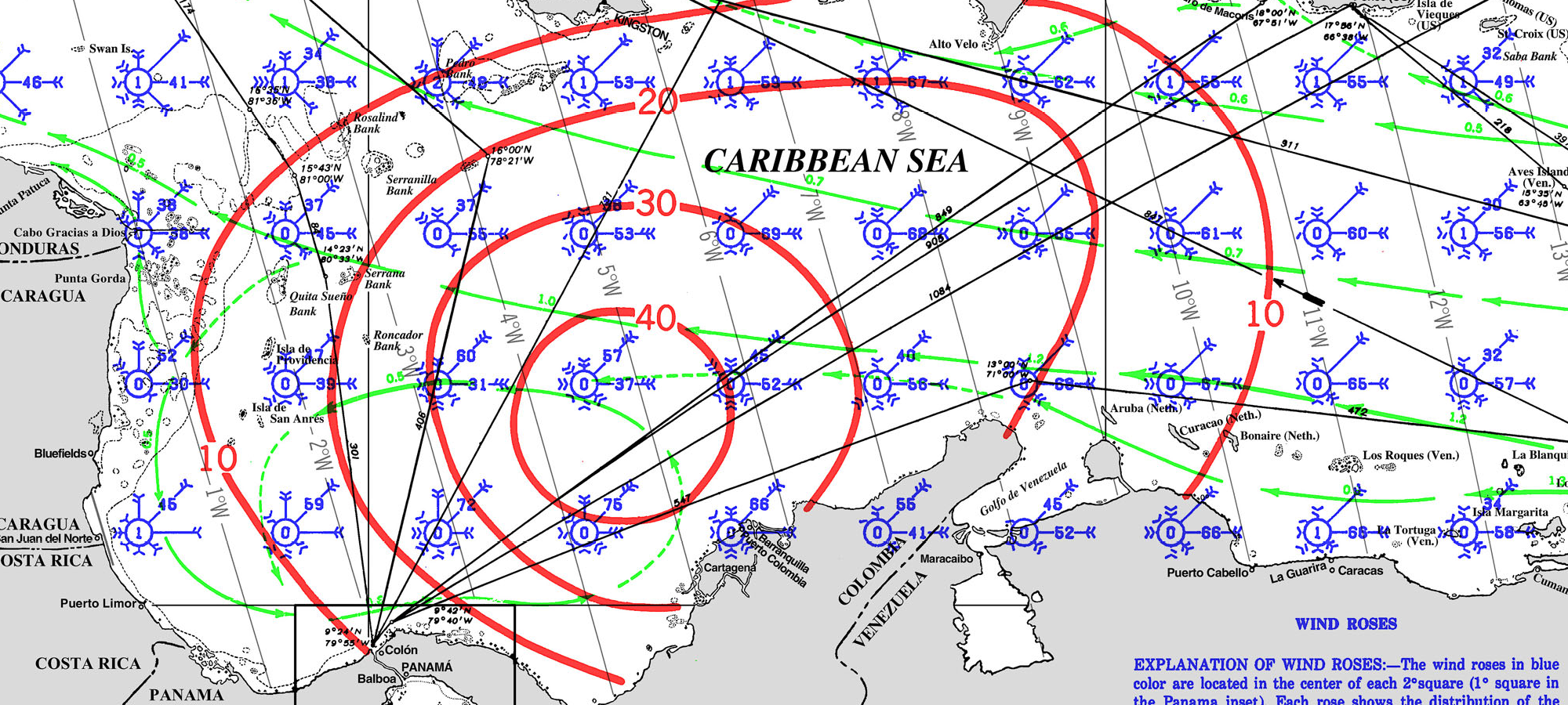
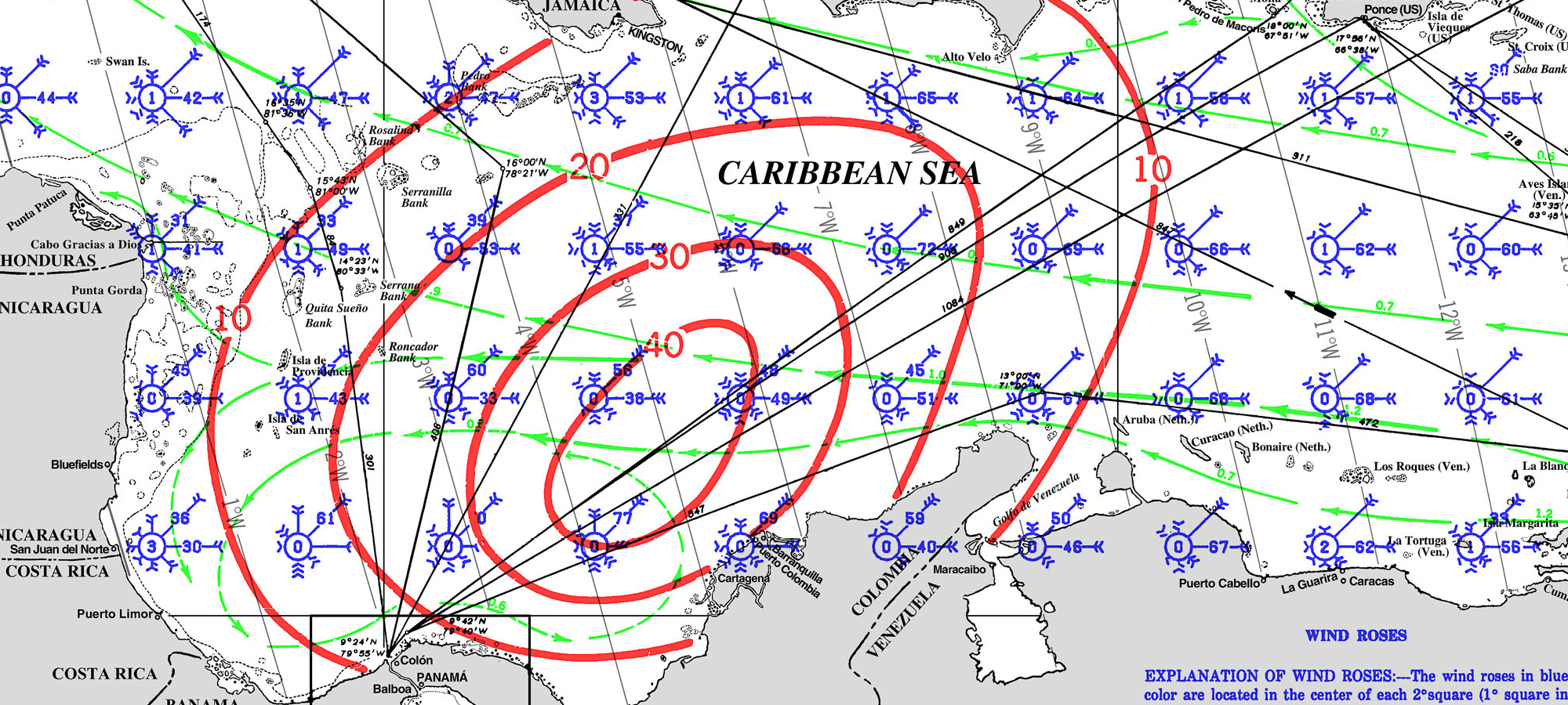
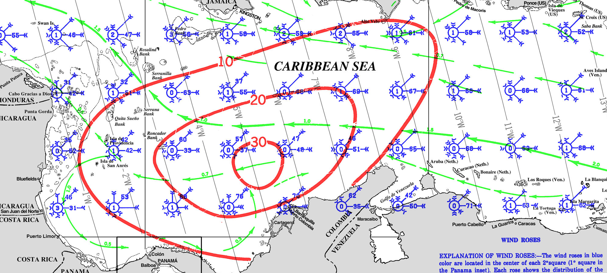
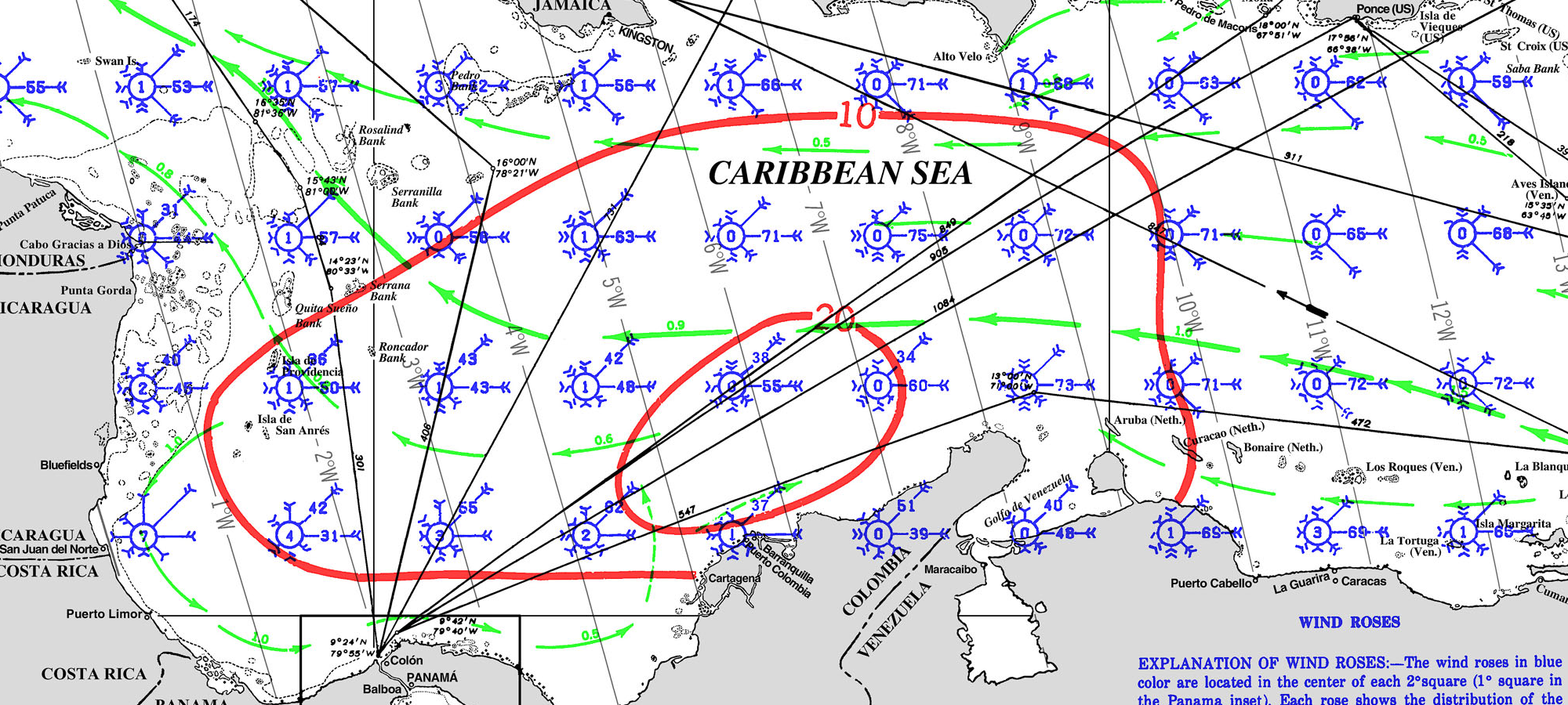
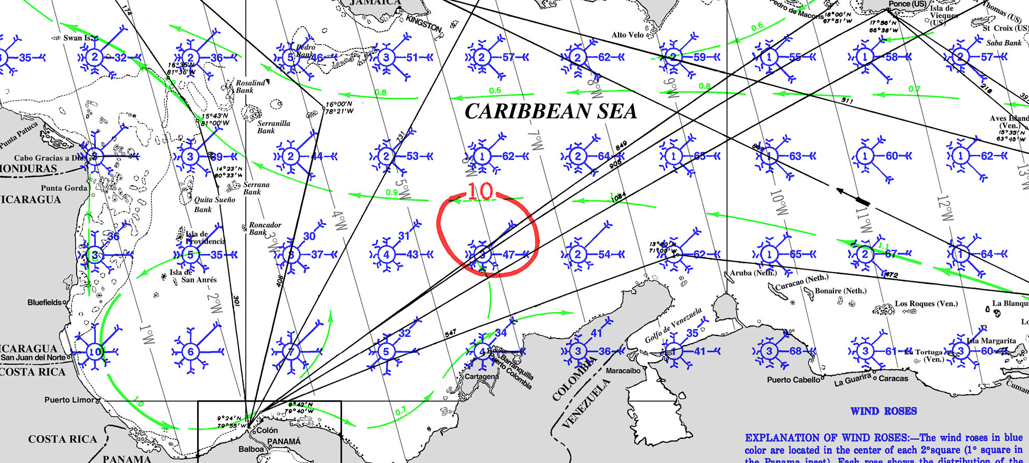
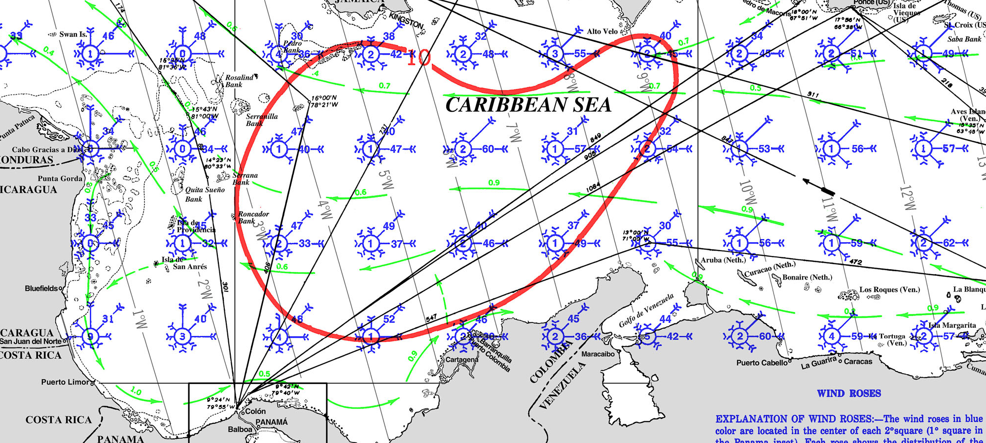
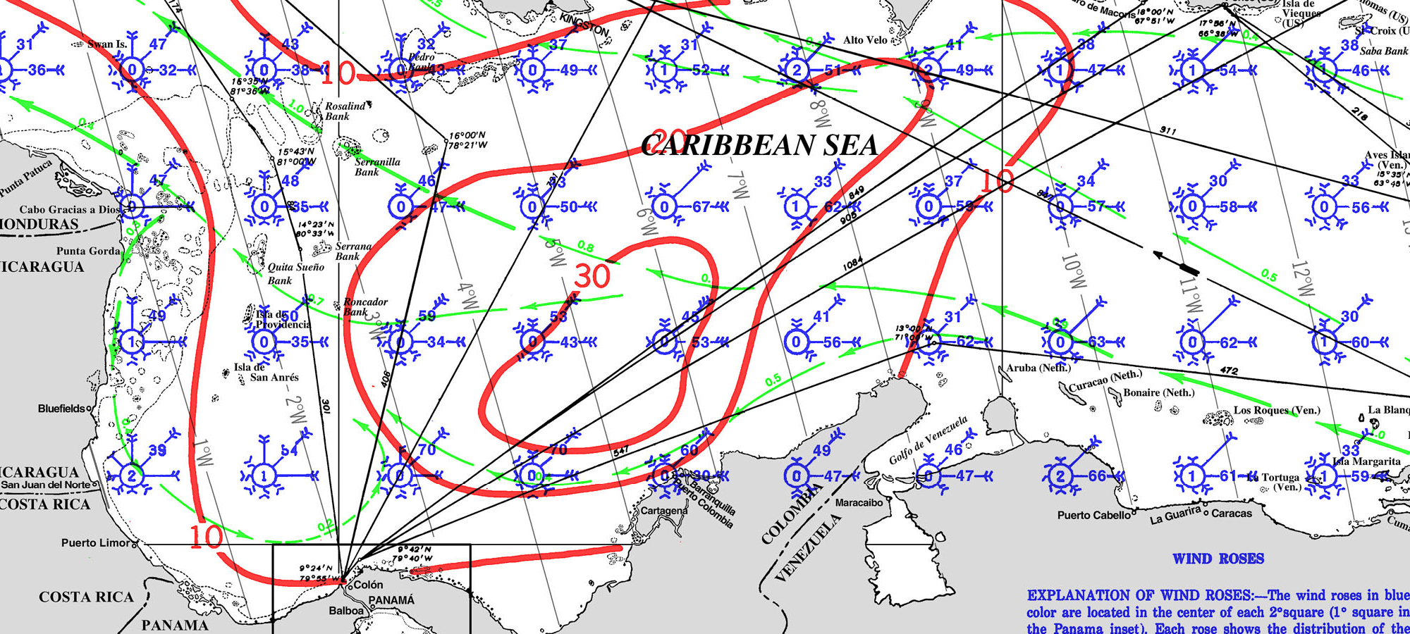
PILOT CHARTS
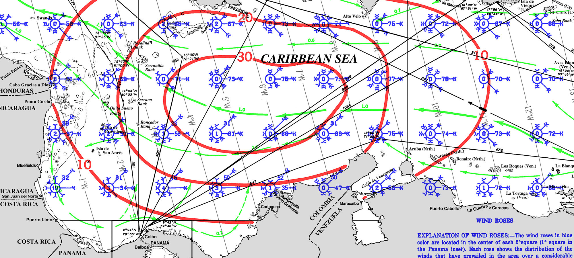
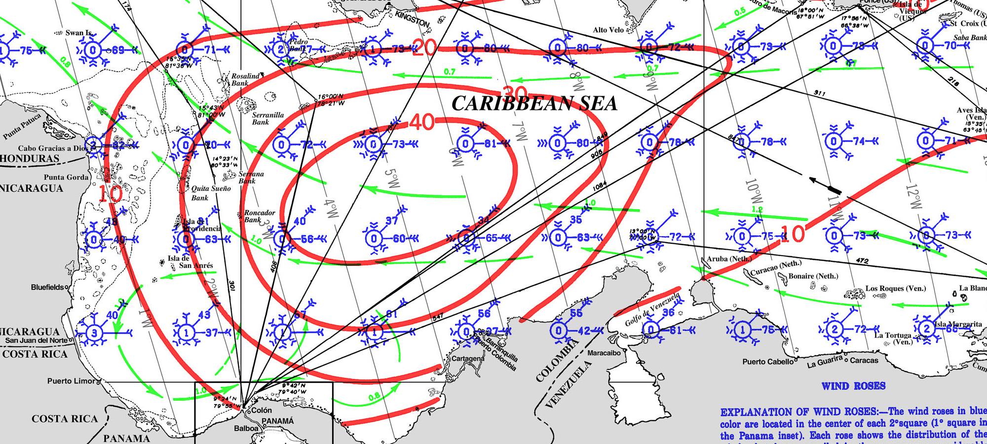
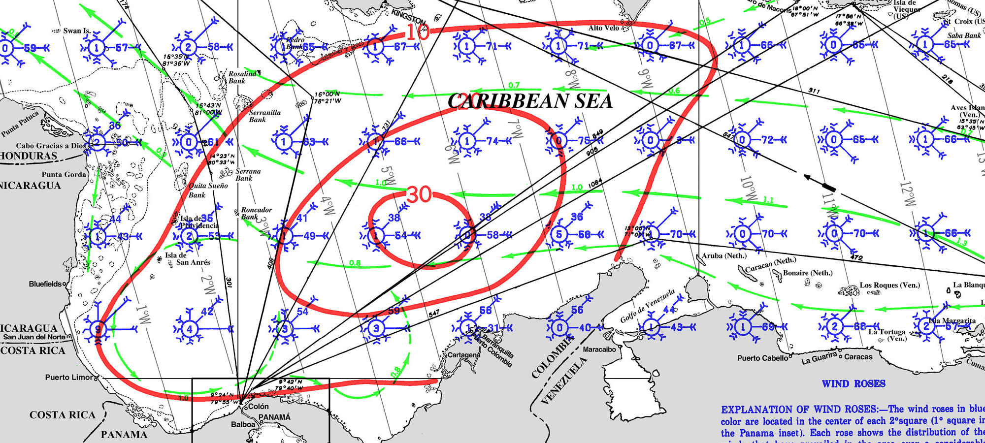
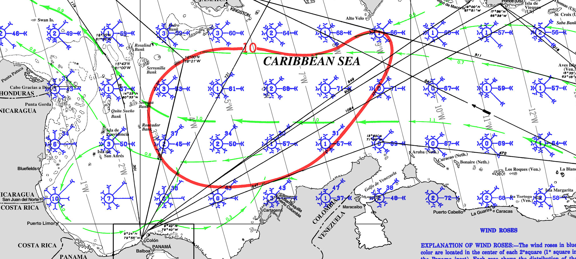
Cuba Pilot Charts provide historic points and aggregated information of wind flows, air and ocean temperatures, wave heights, rain, barometric weight, and climate conditions at various seasons. This data was acquired from oceanographic and meteorologic perceptions over hundreds of years starting in the late eighteenth century. These diagrams are planned to help mariners choose routes around and approaching Cuba with respect to the normal climate and sea conditions using prevailing seasonal wind information. For an explanation of historic Cuban Climatology and how to read Wind-roses follow this link.
PORTS OF ENTRY
US FLAGGED VESSEL NEED USCG AUTHORIZATION TO ENTER CUBA FOLLOW THIS LINK FOR DETAILS >>
Ports of Entry in Cuba
- Havana (Marina Hemingway)
- Coordinates: 23°05.3’N, 82°30.6’W
- Marina Hemingway, located west of Havana, is one of the most popular entry points for yachts arriving from the north.
- Varadero (Marina Gaviota)
- Coordinates: 23°10’N, 81°12’W
- Marina Gaviota is a well-equipped marina on the Hicacos Peninsula, providing a good entry point on the north coast.
- Cienfuegos
- Coordinates: 22°08’N, 80°27’W
- Marina Marlin Cienfuegos is a major entry port on the south-central coast of Cuba, known for its friendly and efficient services.
- Santiago de Cuba
- Coordinates: 20°01’N, 75°48’W
- Marina Santiago de Cuba is an entry port on the southeastern coast, providing necessary amenities for clearing in and out.
- Cayo Largo
- Coordinates: 21°37’N, 81°33’W
- Marina Cayo Largo is an important entry point on the south coast, popular for its beautiful beaches and good facilities.
- Puerto de Vita
- Coordinates: 20°56’N, 75°44’W
- Located in Holguín Province, this port serves as a gateway to the eastern part of Cuba.
- Los Morros (Cabo de San Antonio)
- Coordinates: 21°52’N, 84°56’W
- This port is situated on the western tip of Cuba and serves as an entry and exit point for yachts traveling to or from the Gulf of Mexico.
Important Considerations
- Documentation: Ensure you have all necessary documents, including visas, cruising permits, and health certificates, ready for inspection upon arrival.
- Communication: Contact marinas on VHF before arrival to receive docking instructions and other relevant information.
- Weather: Be aware of seasonal weather patterns, especially the hurricane season from June to November, and plan accordingly.
Sailing to these ports requires adherence to Cuban maritime regulations, and it is recommended to stay updated
DOCUMENTS
CONTACT THE US TREASURE IF YOU ARE A US FLAGGED VESSEL – VIA EMAIL at: OFACLicensing@treasury.gov
YOU NEED COAST GUARD AUTHORIZATION TO ENTER CUBA >>
| DOCUMENTATION | CUBA |
| Passport | Valid for at least 6 months; requires one blank page |
| Boat Documentation | Coast Guard Doc (Original) |
| Proof of Insurance | Liability |
| Crewlist | Required at checkin/out |
| Zarpe | Required at checkin/out |
| OFFICIAL PROCEDURES | HAIL UPON ARRIVAL |
| Official Country Visa | The Tourist Card is valid for 30 days and can be extended for 30 additional days. These usually cost $50-$100. |
| Immigration Visa | 30 days – extentable |
| Required Permits | TBD |
| Upon Arrival Visit: | Immigration; Customs; Port Authority |
| Upon Departure Visit: | Immigration; Customs; Port Captain |
| Entry & Exit Fees: | |
| Notes: | Expect to be boarded by Navy upon entering and/or leaving the country |
| OTHER |
Satellite phones are illegal and may be confiscated.
|
| Required Vaccinations | |
| Pets | Vaccination Certificate |
| CURRENCY RESTRICTIONS |
CURRENCY RESTRICTIONS FOR ENTRY:
U.S. credit and debit cards do not work in Cuba. Bring cash to cover your stay. The Cuban government requires that travelers declare cash amounts over 5,000 USD. CURRENCY RESTRICTIONS FOR EXIT:
The export of Cuban convertible pesos (CUC) is strictly prohibited, regardless of the amount. When departing Cuba, U.S. travelers are advised to exchange Cuban convertible pesos (CUC) back to US Dollars well before reaching airport security checkpoints to avoid potential confiscation of the CUC. For other currencies, travelers may export up to the equivalent of 5,000 USD. Anyone wishing to export more than this amount must demonstrate evidence that the currency was acquired legitimately from a Cuban bank. |
| Currency: Cuban Peso |
 American Dollar to
  Cuban Peso
| Crime Index | Safety Index | Corruption Index | Corruption Score | GDP x capita | Pop (M) | Life Ex. | Cost of Living | Groc. | Rest. $ | Loc.Purch.P. |
| 5.0 | 48.9548.95 |
60/180 |
47% | 8,821 | 11.35 | 78.66 |
US EMBASSY
TEL +57 1 2752000
Cl. 24 Bis #48-50, barrio, Bogotá, Colombia
TEL +53 7 8394100
https://cu.usembassy.gov/
CHARTS
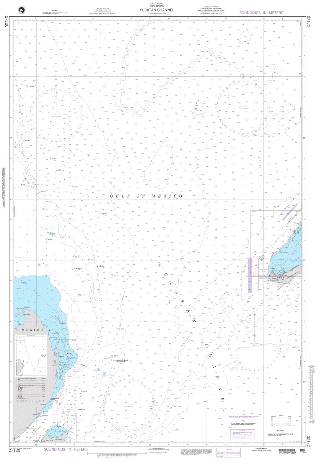
Yucatan Channel – CUBA 27120
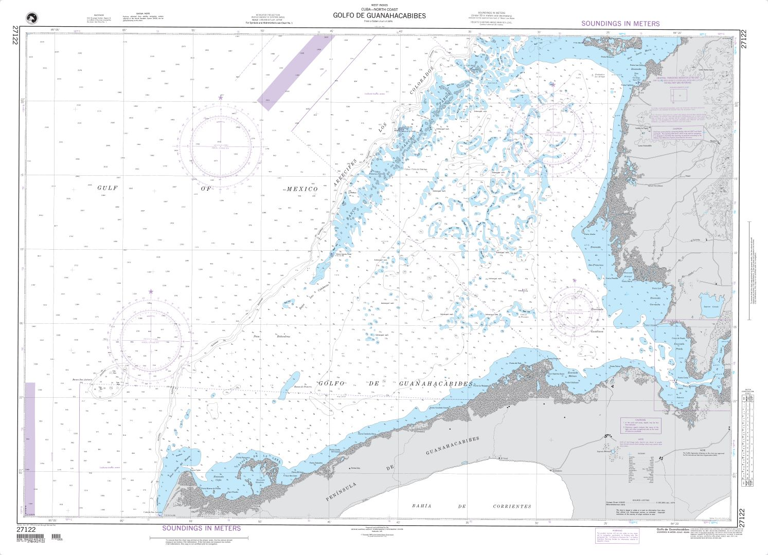
Golfo de Guanahacabibes – CUBA – 27122
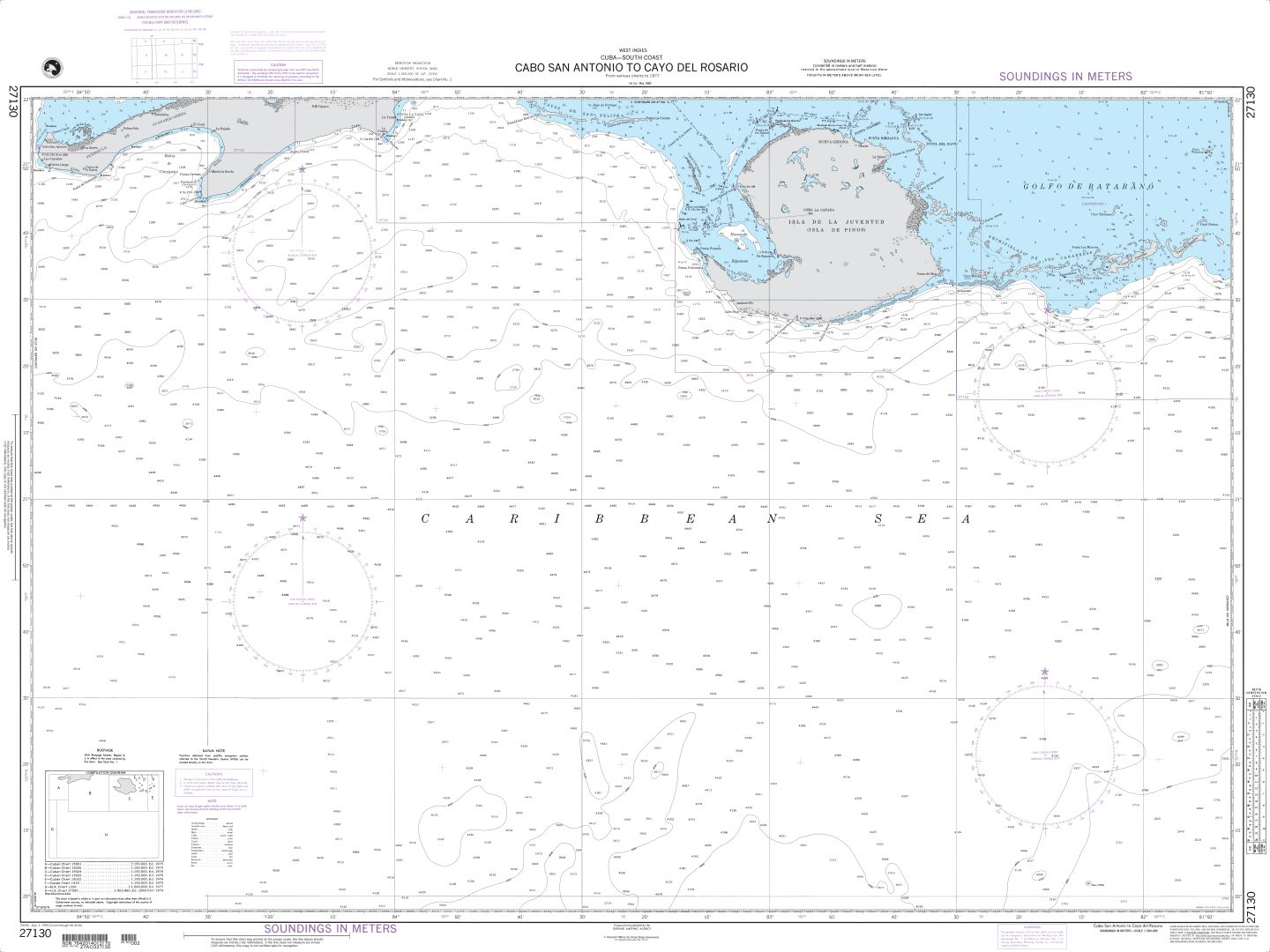
Cabo San Antonio to Cayo del Rosario CUBA 27130
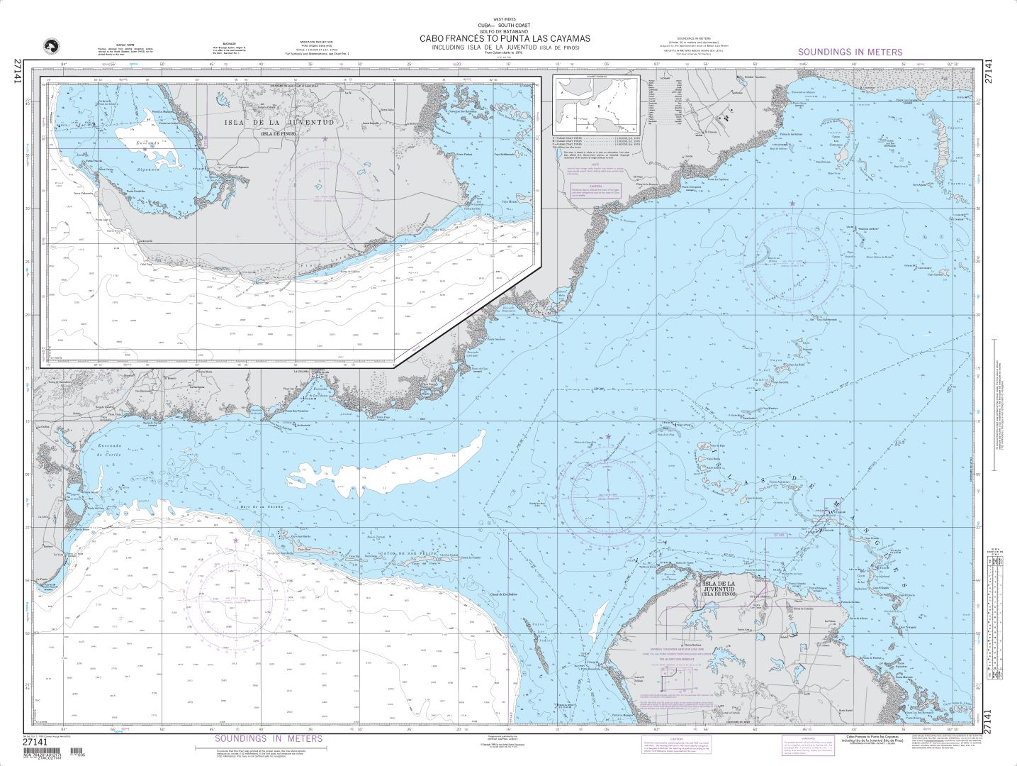
Cabo Frances to Punta Las Cayamas including Isla de la Juventud (Isla de Pinos) – CUBA 27141
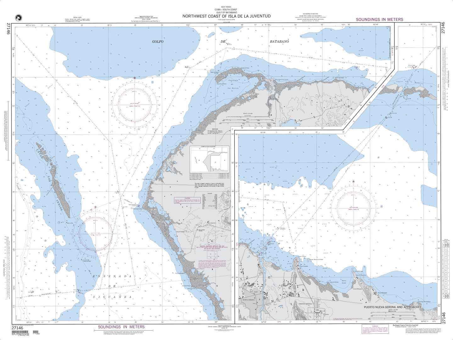
Northwest Coast of Isla de la Juventud – CUBA 27146
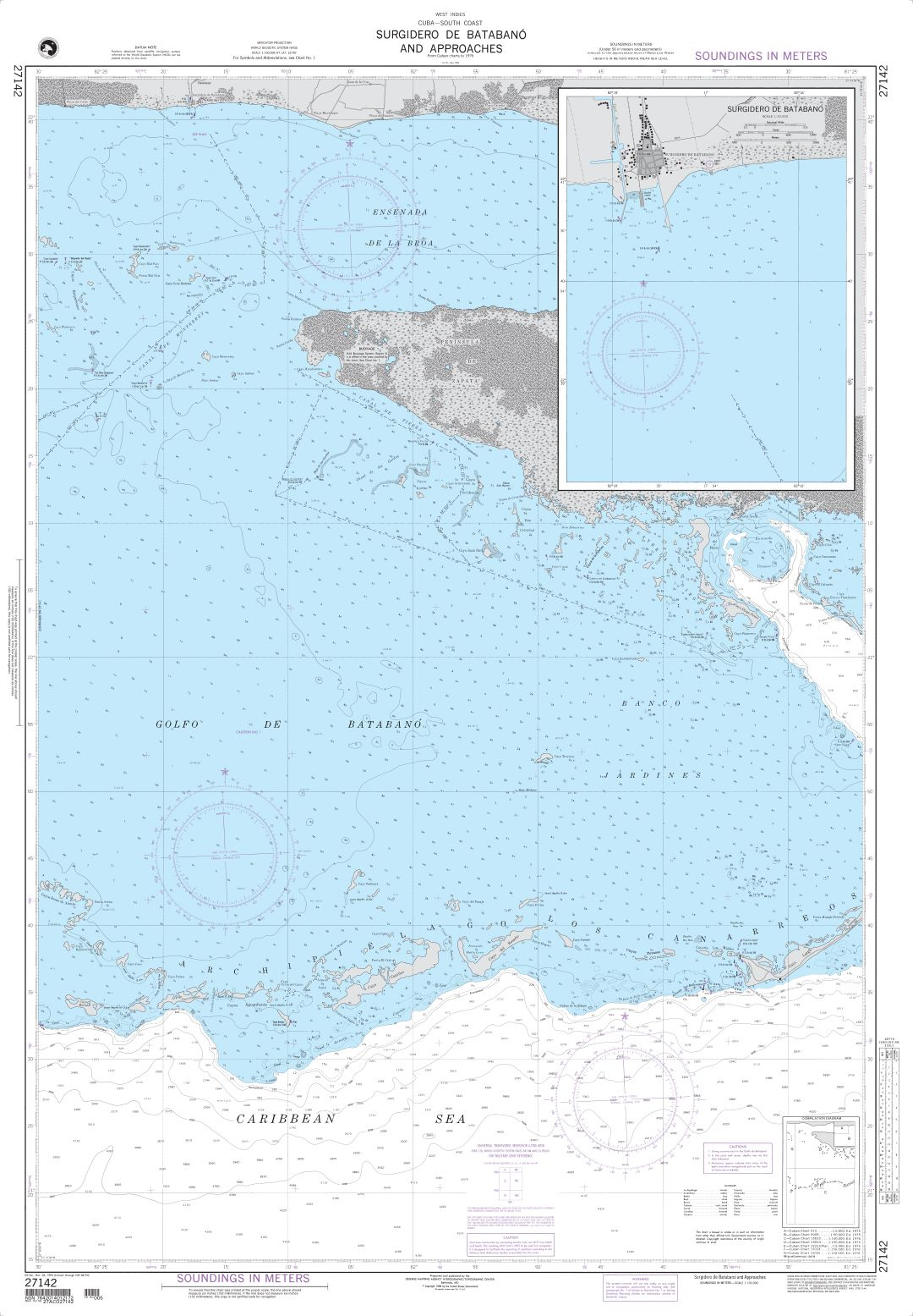
Surgidero de Batabano and Approaches – CUBA 27142
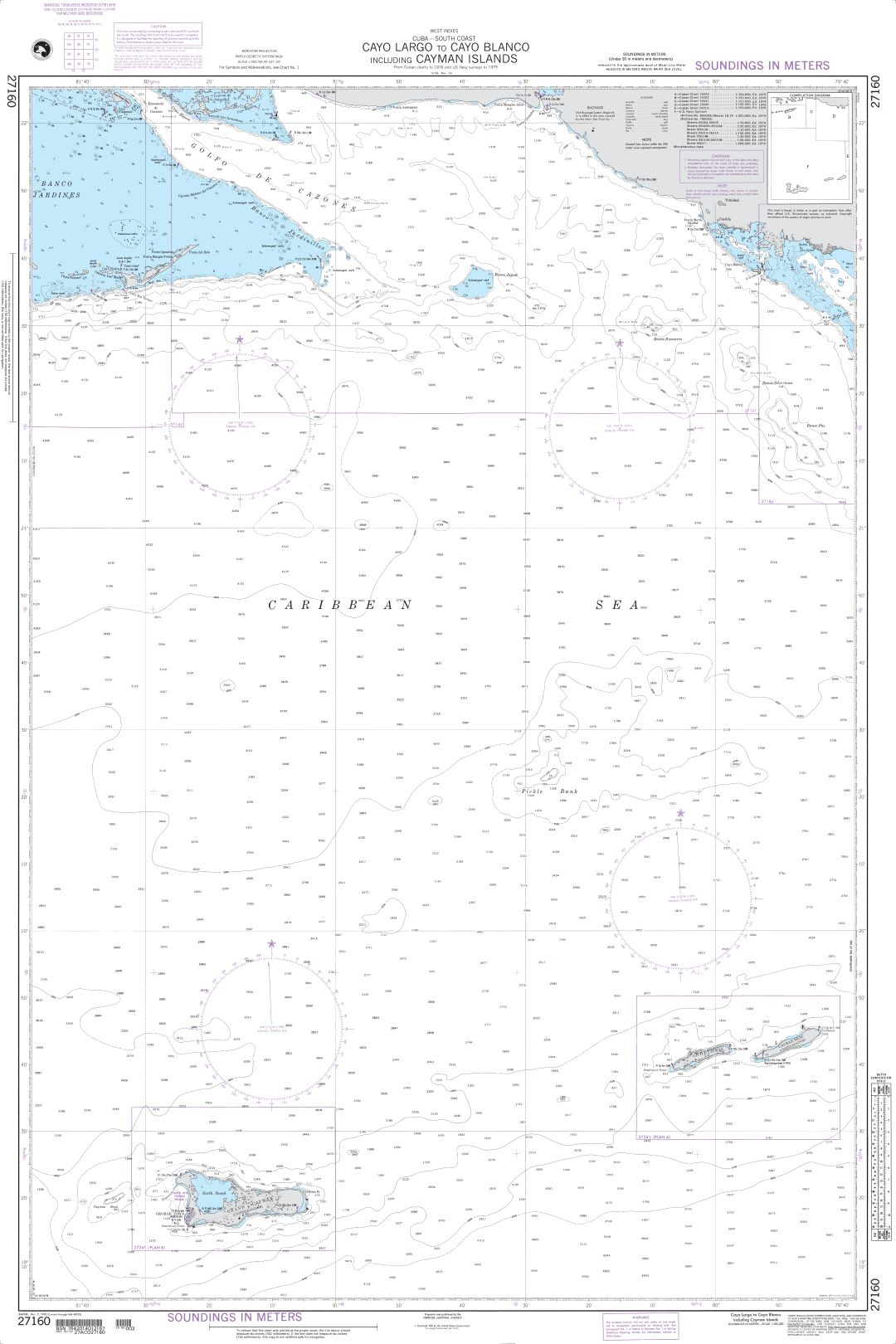
Cayo Largo to Cayo Blanco including Cayman Islands – CUBA 27160
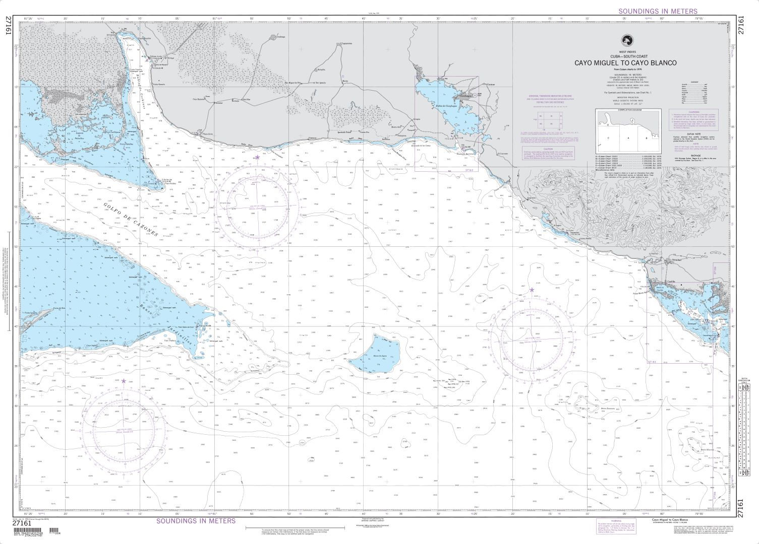
Cayo Miguel to Cayo Blanco – CUBA 27161
Approaches to the Port of Casilda – CUBA 27183
Tunas de Zaza and Approaches – CUBA 27186
Punta Colorado to Jucaro – CUBA 27184
Punta Charcas to Jucaro – CUBA 27202
Jucaro to Cayos Gitanos – CUBA 27201
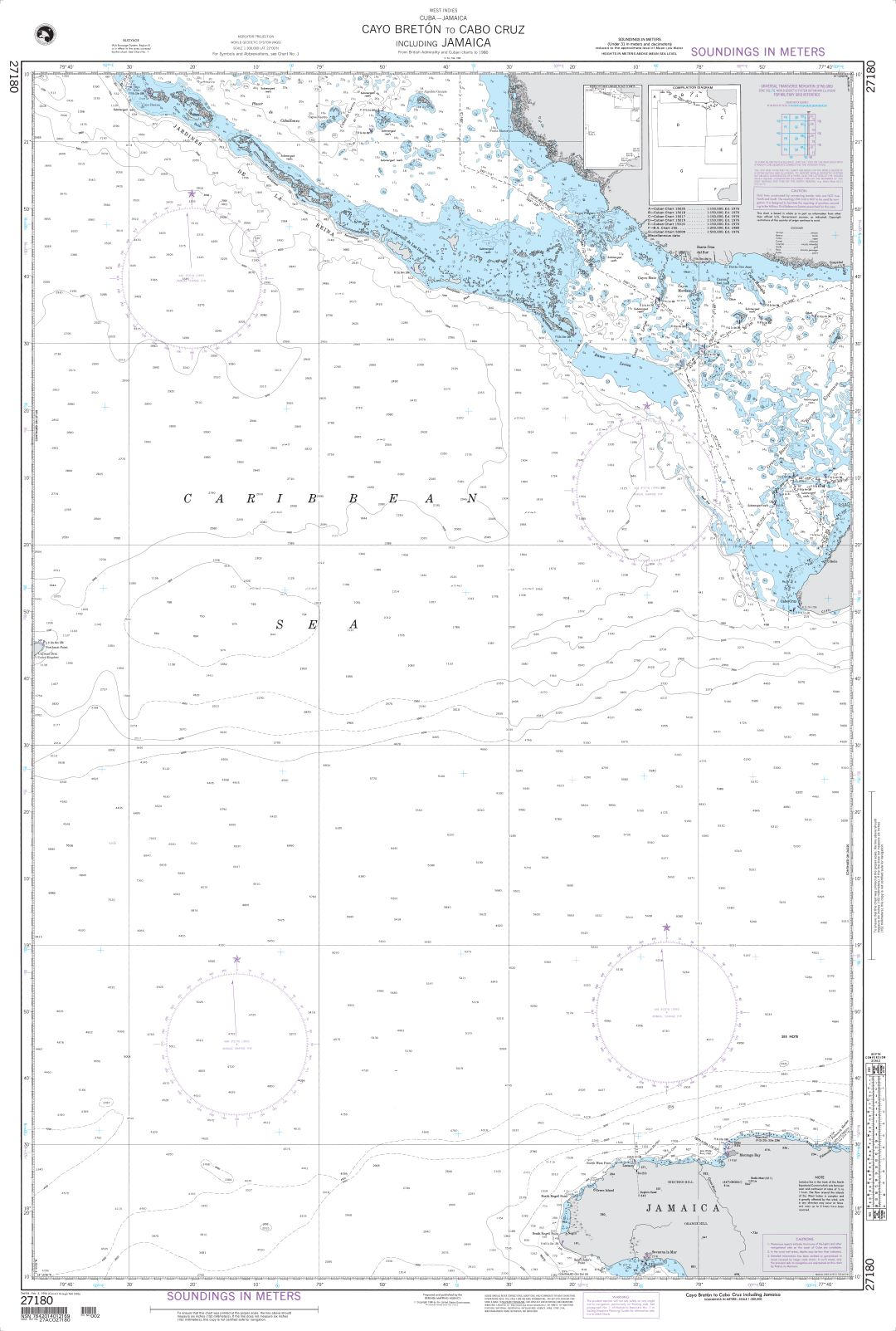
Cayo Breton to Cabo Cruz including Jamaica – CUBA JAMAICA 27180
Cayo Yuraguana to Cayos Manopla – CUBA 27211
Punta San Jose to Manzanillo – CUBA 27207
Niquero to Manzanillo including Canal de Madrona – CUBA 27206
Pilon to La Marea del Portillo – CUBA 27222
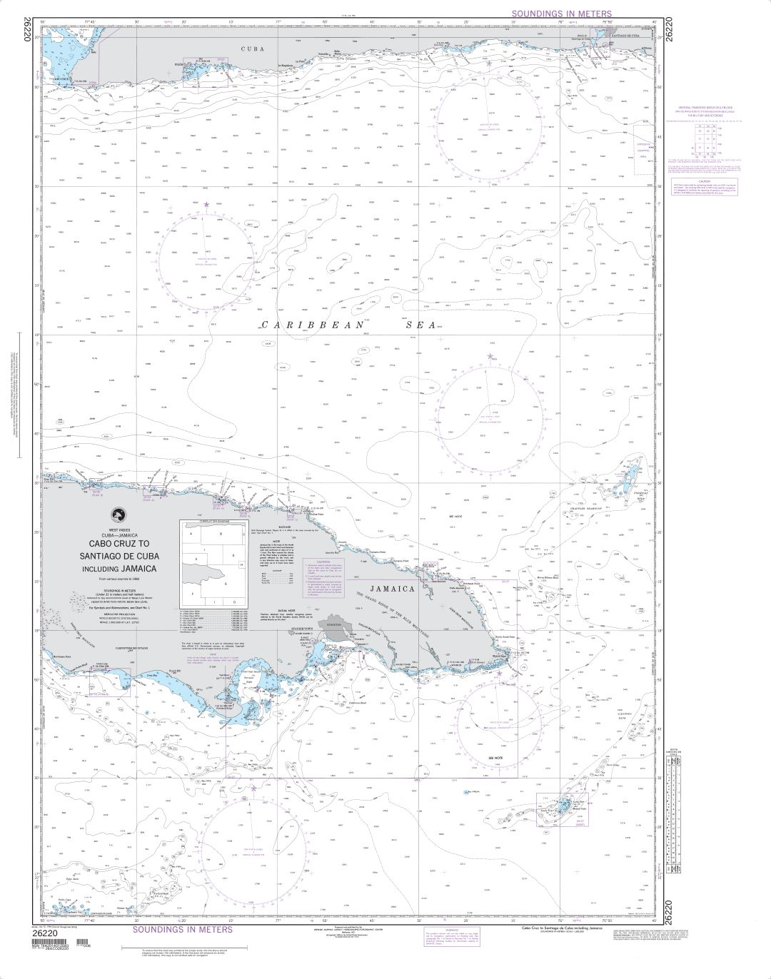
Cabo Cruz to Santiago de Cuba including Jamaica – CUBA 26220
Bahia de Santiago de Cuba – CUBA 26224
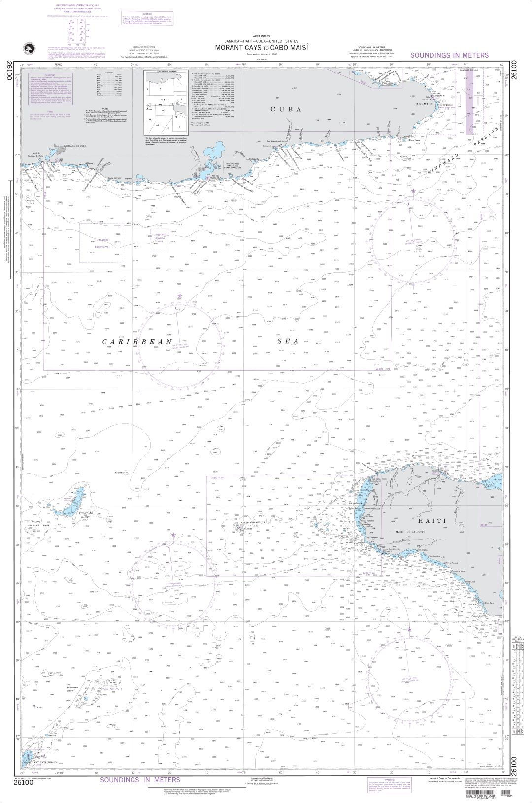
Morant Cays to Cabo Maisi – CUBA 26100
Crooked Island Passage to Punta de Maisi – CUBA 26240
Punta Silencio to Bahia de Sama – CUBA 26244
Bahia de Nipe – CUBA 26259
Plans on the North Coast of Cuba A. Puerto Gibara – CUBA 26250
Entrance Channel to Bahia de Banes – CUBA 26247
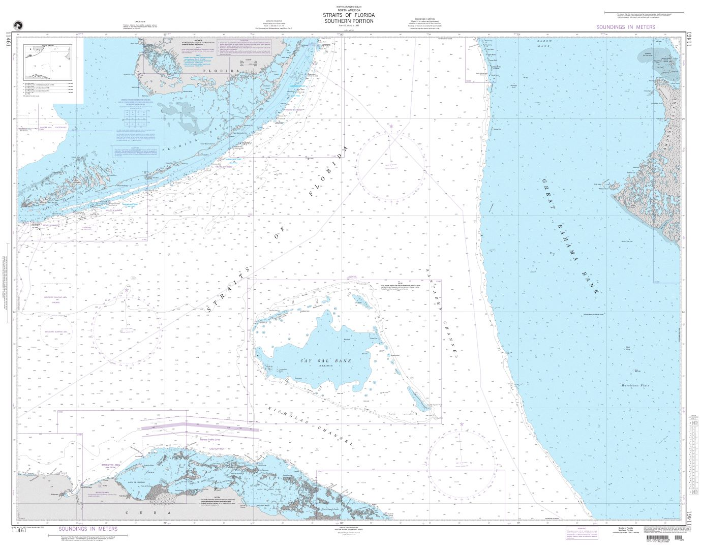
Straits of Florida-Southern Portion – CUBA / FLORIDA 11461
Caribbean Sea – CUBA 402
Havana to Tampa Bay – CUBA FLORIDA – 4148
Straits of Florida – Eastern Part – CUBA FLORIDA BAHAMAS 4149
De Florida à Cuba – Bahamas Islands – CUBA SHOM 7473
AIDS TO NAVIGATION
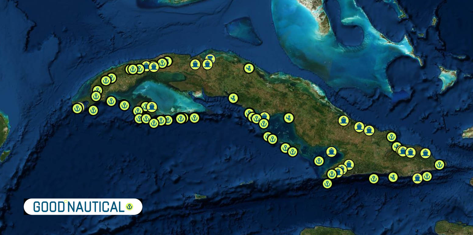
Check Good Nautical for anchorages marinas and harbors


MUST SEE
UNESCO World Heritage Sites
- Old Havana and its Fortification System
- Coordinates: 23.1353° N, 82.3589° W
- Trinidad and the Valley de los Ingenios
- Coordinates: 21.8040° N, 79.9836° W
- San Pedro de la Roca Castle, Santiago de Cuba
- Coordinates: 19.9703° N, 75.8654° W
- Viñales Valley
- Coordinates: 22.6182° N, 83.7248° W
- Archaeological Landscape of the First Coffee Plantations in the South-East of Cuba
- Coordinates: 20.2064° N, 75.9836° W
- Urban Historic Centre of Cienfuegos
- Coordinates: 22.1490° N, 80.4350° W
- Historic Centre of Camagüey
- Coordinates: 21.3808° N, 77.9169° W
- Alejandro de Humboldt National Park
- Coordinates: 20.5039° N, 74.5964° W
- Desembarco del Granma National Park
- Coordinates: 19.7678° N, 77.6189° W
- Cienaga de Zapata National Park
- Coordinates: 22.3706° N, 81.2162° W
Must-See Locations
- El Malecón, Havana
- Coordinates: 23.1416° N, 82.3598° W
- Capitolio, Havana
- Coordinates: 23.1387° N, 82.3590° W
- Plaza de la Revolución, Havana
- Coordinates: 23.1188° N, 82.3866° W
- Cayo Largo del Sur
- Coordinates: 21.6175° N, 81.5586° W
- Cayo Coco
- Coordinates: 22.5117° N, 78.4003° W
- Cayo Guillermo
- Coordinates: 22.5956° N, 78.6523° W
- Varadero Beach
- Coordinates: 23.1361° N, 81.2445° W
- Pico Turquino, Sierra Maestra
- Coordinates: 20.0198° N, 76.8258° W
- Baracoa
- Coordinates: 20.3480° N, 74.4965° W
- Jardines de la Reina National Park
- Coordinates: 20.8333° N, 78.9167° W
- Santa Clara (Che Guevara Mausoleum)
- Coordinates: 22.4135° N, 79.9643° W
- Bay of Pigs
- Coordinates: 22.1683° N, 81.1964° W
- Soroa Orchid Botanical Garden
- Coordinates: 22.8057° N, 83.0084° W
- Cueva del Indio, Viñales
- Coordinates: 22.6055° N, 83.7133° W
- Playa Ancón
- Coordinates: 21.7597° N, 79.9614° W
- El Nicho Waterfalls
- Coordinates: 22.1242° N, 80.1614° W
- Cayo Santa Maria
- Coordinates: 22.6167° N, 79.1500° W
- Baconao Park
- Coordinates: 20.0172° N, 75.7553° W
- Gran Teatro de La Habana
- Coordinates: 23.1381° N, 82.3582° W
- Museo Nacional de Bellas Artes, Havana
- Coordinates: 23.1385° N, 82.3527° W
- Museo Romántico, Trinidad
- Coordinates: 21.8065° N, 79.9830° W
- Valle de los Ingenios
- Coordinates: 21.7972° N, 79.9833° W
These locations encompass a diverse array of Cuba’s cultural, historical, and natural attractions, making them essential stops for any visitor to the island.
REPAIRS AND SERVICE PROVIDERS
EMERGENCIES AND SAR INFO
MRCC Cuba/Cuban Border Guard
Type: MRCC, Country: Cuba, SRR: SRR CUBA
Latitude, Longitude:
(23.04833031,-82.41667175)
Telephone:
011 537 273 0364
Email:
Fax:
53 7 336684
Website:
INMARSAT:
Installation in progress Dec 2002
Telex:
307 511598
Notes:
A network of coast radio stations maintain a continuous listening watch on international distress frequencies.
COMMUNICATIONS
Levels of Communication in Cuba
Communication in Cuba can be categorized into official and unofficial (illegal) channels, reflecting the unique socio-political context of the island. Here’s a detailed look at the different levels:
Official Channels of Communication
- Telecommunications (ETECSA)
- Telephones: Cuba’s primary telecommunications provider is ETECSA (Empresa de Telecomunicaciones de Cuba S.A.), which offers landline and mobile phone services. Landlines are more common in urban areas, while mobile phone usage is widespread.
- Mobile Networks: ETECSA provides GSM and 3G services, and 4G LTE has been rolled out in major cities since 2019. The mobile network uses the 900 MHz band for 3G and the 1800 MHz band for 4G.
- Internet Access: Internet in Cuba is controlled by ETECSA. Public Wi-Fi hotspots are available in parks, hotels, and other public areas, but connectivity can be slow and expensive. Home internet is available but limited.
- Mail and Postal Services
- Correo de Cuba: The national postal service, Correo de Cuba, handles domestic and international mail. The service can be slow, and delivery times are unpredictable.
- State Media
- Television: The Cuban government operates several television channels, including Cubavisión, Tele Rebelde, Canal Educativo, and Canal Caribe. These channels broadcast news, educational programs, and entertainment content aligned with state policies.
- Radio: Radio is a crucial medium in Cuba. Major stations include Radio Rebelde, Radio Reloj, and Radio Habana Cuba, which provide news, music, and cultural programming.
- Print Media: Newspapers like Granma (the official publication of the Communist Party), Juventud Rebelde, and Trabajadores are widely circulated and serve as the primary source of print news.
Unofficial (Illegal) Channels of Communication
- El Paquete Semanal
- Content Distribution: El Paquete Semanal (The Weekly Package) is a popular and unofficial means of distributing digital content. It consists of a one-terabyte collection of movies, TV shows, music, software, and other media, distributed weekly via external hard drives and USB drives.
- Accessibility: It is sold in street markets and distributed privately, bypassing government controls. It is an essential source of entertainment and information for many Cubans who have limited internet access.
- Satellite Television
- Illegal Satellite Dishes: Despite being illegal, many Cubans use satellite dishes to access foreign television channels. This allows them to watch content from international broadcasters, including news and entertainment programs not available on state-controlled media.
- Private Wi-Fi Networks
- SNet: SNet (Street Network) is a large community-created mesh network that connected thousands of users across Havana before being partially shut down by authorities. It allowed users to share files, chat, and play games over a local network without internet access.
- Home Networks: Some Cubans create local networks within their homes or neighborhoods to share content and communicate more freely.
- Social Media and Messaging Apps
- VPN Usage: To bypass internet censorship, some Cubans use Virtual Private Networks (VPNs) to access restricted websites and social media platforms. Apps like WhatsApp, Facebook Messenger, and Telegram are popular for communication.
- Offline Messaging: Apps like Zapya and SHAREit are used to transfer files and messages via Bluetooth and Wi-Fi Direct, allowing communication without internet access.
Challenges and Limitations
- Internet Restrictions: The Cuban government restricts access to certain websites and monitors online activities. Internet speeds are generally slow, and data packages are expensive relative to average incomes.
- Surveillance: There is significant state surveillance of communications, and criticism of the government can lead to repercussions.
- Limited Access: Rural areas often have limited access to telecommunications infrastructure, further widening the digital divide within the country.

COLOMBIA 🇨🇴 CRUISING CENTRAL AMERICA WITH THE OCEAN POSSE
COLOMBIA 🇨🇴 CRUISING CENTRAL AMERICA WITH THE OCEAN POSSE
 Cruising the Caribbean Waters of Colombia
The Caribbean coast of Colombia offers a treasure trove of experiences for yacht enthusiasts. From the historic city of Cartagena to the pristine beaches of Tayrona National Park, this region is a haven for sailors looking to explore diverse landscapes, vibrant culture, and rich history. This guide provides detailed information on destinations, anchorages, sailing conditions, costs, and practical tips for cruising the Caribbean coast of Colombia.
Cartagena
Cartagena is a prime starting point for cruisers. The city’s protected harbor is one of the safest and most accessible along the Caribbean coast. The Club Náutico Cartagena offers excellent facilities, including mooring, fuel, water, and repair services.
Anchorages:
- Bahía de Cartagena: Located just outside the walled city, this anchorage provides good holding in mud and sand. Be mindful of the heavy boat traffic.
- Isla de Barú: South of Cartagena, offers a more tranquil anchorage with clear waters and beautiful beaches.
Shore Excursions: Explore the historic walled city, visit the Castillo San Felipe de Barajas, and enjoy the vibrant nightlife and culinary scene.
Rosario Islands
Coordinates: 10.1741° N, 75.7396° W
A short sail from Cartagena, the Rosario Islands are part of a national park known for their coral reefs and clear waters. This area is ideal for snorkeling, diving, and relaxing.
Anchorages:
- Isla Grande: Offers several good anchorages with sandy bottoms. Be sure to anchor outside the designated swimming and diving areas.
- Isla del Rosario: Offers a marina with mooring buoys and services for yachts.
Activities: Snorkeling, diving, kayaking, and visiting the Oceanarium to learn about marine conservation efforts.
Santa Marta
Coordinates: 11.2408° N, 74.1990° W
Santa Marta is Colombia’s oldest city and a gateway to the Sierra Nevada mountains. The Marina Santa Marta is well-equipped, offering modern amenities and 256 berths for yachts.
Anchorages:
- IGY Marina Santa Marta: Offers secure berthing with excellent facilities including fuel, water, electricity, and is an Ocean Posse Sponsor
- Taganga Bay: Just north of Santa Marta, this bay offers a quieter anchorage with good holding in sand.
Shore Excursions: Visit the historic center, the Gold Museum, and the nearby beaches of Rodadero and Taganga.
Tayrona National Park
Coordinates: 11.3193° N, 73.9128° W
Tayrona National Park is a pristine natural area with stunning beaches and lush forests. It’s a perfect spot for nature lovers and those looking to escape the hustle and bustle.
Anchorages:
- Cabo San Juan: Offers a scenic anchorage with good holding in sand. Be mindful of the reef and approach slowly.
- Bahía Concha: Another popular anchorage with calm waters and beautiful surroundings.
Activities: Hiking, birdwatching, snorkeling, and exploring the archaeological site of Pueblito.
San Andrés and Providencia
Coordinates: San Andrés (12.5847° N, 81.7006° W), Providencia (13.3726° N, 81.3590° W)
These remote islands offer crystal-clear waters and a laid-back atmosphere. San Andrés is known for its duty-free shopping, while Providencia offers some of the best diving spots in the Caribbean.
Anchorages:
- San Andrés Marina: Offers secure berthing with all necessary services.
- Southwest Bay (Providencia): A sheltered anchorage with good holding in sand.
Activities: Diving, snorkeling, exploring the island on scooters or bikes, and enjoying local cuisine.
FLAG HISTORY OF COLOMBIA

MARINAS IN COLOMBIA
PANAMA POSSE SPONSORSHIP MARINAS
- IGY Marina Santa Marta

- Club Nautico de Cartagena
- Marina Puerto Velero
- Club de Pesca Marina Cartagena
- Manzanillo Club Marina
- Marina Portobello
PANAMA POSSE SPONSORSHIP Agents
WEATHER
Prevalent trade winds bend along the coast from east really hard, especially along the northern eastern coast between late December through April. All year long however every near-shore winds will let up producing manageable jumps for vessels heading east. May through September, Colombia on the Caribbean side, faces long periods with hot and sticky conditions followed but thunderstorms and as a consequence you have minimal near-shore winds. Early fall can even produce westerlies. Winds and waves are significantly reduced closer to shore. As always do not sail on this coast on a schedule !
PILOT CHARTS
Pilot Charts depict averages in prevailing winds and currents, air and sea temperatures, wave heights, visibility, barometric pressure, and weather conditions at different times of the year. The information used to compile these averages was obtained from oceanographic and meteorologic observations over many decades during the late 18th and 19th centuries.The charts are intended to aid the navigator in selecting the fastest and safest routes with regards to the expected weather and ocean conditions. For an explanation of historic Colombian Climatology and how to read Wind-roses follow this link.
PORTS OF ENTRY
Caribbean Coast
- Cartagena
- Description: Cartagena is a popular entry point with excellent marina facilities, including Club Náutico Cartagena and Marina Club de Pesca.
- Coordinates: 10.3910° N, 75.4794° W
- Santa Marta
- Description: Santa Marta Marina provides modern amenities and is an ideal spot for exploring the historic city and nearby natural attractions.
- Coordinates: 11.2408° N, 74.1990° W
- Barranquilla
- Description: A significant commercial port that also handles yacht clearances.
- Coordinates: 10.9685° N, 74.7813° W
- Puerto Velero
- Description: Located near Barranquilla, this port offers a marina with haul-out and dry storage facilities.
- Coordinates: 10.9598° N, 75.0345° W
- Riohacha
- Description: A less frequented port but available for yacht entry.
- Coordinates: 11.5449° N, 72.9076° W
- Sapzurro
- Description: Located near the Panama border, Sapzurro is a picturesque village offering a sheltered bay for anchoring.
- Coordinates: 08° 39’N, 77° 21’W
Off-lying Islands in the Caribbean
- Isla de San Andrés
- Description: Known for its duty-free shopping and vibrant atmosphere.
- Coordinates: 12.5847° N, 81.7006° W
- Isla de Providencia
- Description: A quieter island with excellent diving spots.
- Coordinates: 13.3726° N, 81.3590° W
Pacific Coast
- Bahia Solano
- Description: A port on the Pacific coast with entry facilities.
- Coordinates: 6.2251° N, 77.4056° W
- Buenaventura
- Description: The largest port on Colombia’s Pacific coast, primarily commercial but also handles yacht clearances.
- Coordinates: 3.8833° N, 77.0667° W
- Tumaco
- Description: Another entry port on the Pacific coast, less frequented by yachts.
- Coordinates: 1.7981° N, 78.7887° W
These ports provide various services and facilities to accommodate cruising yachts, from modern marinas in Cartagena and Santa Marta to more remote and tranquil anchorages in Sapzurro and Providencia. It’s advisable to check the latest entry requirements and communicate with the marinas in advance to ensure a smooth arrival process
CHARTS
AIDS TO NAVIGATION
Download the official Colombian Government Cruising Guide (SPANISH) from here :
https://cecoldodigital.dimar.mil.co/51/1/dimarcioh_2012_2256-5914_guia_nautica_turistica_colombia.pdf Cruising Guides for the area can be found here : BOOKS PORT GUIDE CRUISING GUIDE TO CARTAGENA
GOOD NAUTICAL
- 261 Bahía de Cartagena
- 263 Bahía Interna de Cartagena
- 264 Entrada a la Bahía de Cartagena
- 843 Canal Acceso a Bahía de Cartagena
- BBA-1 Bahía De Las Ánimas
- BBT-2 Terminal Turístico
- BID-3 Isla del Diablo
- BCO-4 Sector Del Bosque Marina Manzanillo (Contecar)
- 255 Archipiélago Islas del Rosario
- BIR-4 Isla Tesoro
- BIR-5 Islas Del Rosario a Isla Grande
- BIR-6 Isla Grande
- BIR-7 Isla Periquito Cholón
- BIR-8 Islas Del Rosario Islas Rosario
- BIR-9 Isla Arena
- BIR-10 Isla Arena a Isla Barú
- COL 259 Archipiélago San Bernardo
- BSB-1 Isla Tintipán
- BSB-2 Isla Múcura
- BSB-3 Isla Múcura a Isla Panda
- BSB-5 Isla Palma
- BSB-6 Isla Panda
- BSB-7 Isla Ceycen
- BIF-8 Isla Fuerte
- 040 Península de la Guajira
- GCV-1 Cabo de La Vela
- GMA-2 Manaure
- GRI-3 Riohacha
- GDI-4 Dibulla
- MEC-1 Ensenada Cinto
- MEN-2 Ensenada Nenguange
- MEG-3 Ensenada Gairaca
- MEC-4 Ensenada Concha
- MBT-5 Bahía de Taganga
- MBS-6 Bahía de Santa Marta
- MRO-7 Bahía de Gaira (El Rodadero)
- APC-1 Puerto Colombia
- APV-2 Puerto Velero
- SPB-1 Punta San Bernardo
- SST-2 Tolú
- SCO-3 Coveñas
- SBC-4 Bahía de Cispatá
- SSA-5 San Antero
- SBV-6 San Bernardo del Viento
- CMO-1 Moñitos
- CPE-2 Puerto Escondido
- CLC-3 Los Córdobas
- 412 Golfo de Urabá
- 295 Bahía Colombia
- CBT-1 Triganá
- CAC-2 Acandí
- CCA-3 Bahía de Capurganá
- CSA-4 Bahía de Sapzurro
- COL 004 Archipiélago de San Andrés y Providencia
- SAI-1 Rada el Cove
- SAI-2 Club Náutico San Andrés
- SAI-3 Bahía de Santa Catalina
- SAI-4 Aproximación a Santa Catalina
- SAI-5 Agua Dulce South West Providencia
CHARTS COLOMBIA PACIFIC
- INT 6000 / 003
- CBS-6 Bahía Solano
- INT 6105 Golfo de Cupica a Buenaventura
- INT 6110 Bahía de Buenaventura a bahía Ancon de Sardinas
- 153 Bahía de Buenaventura
- 730 Puerto de Buenaventura
- 521 Isla de Malpelo
- 520 Isla Gorgona
- 101 Aproximación a Tumaco
- 100 Puerto de Tumaco
GOOD NAUTICAL
DOCUMENTS
| DOCUMENTATION | COLOMBIA |
| Passport | Valid for at least 6 months; requires one blank page |
| Boat Documentation | Coast Guard Doc (Original) |
| Proof of Insurance | Liability |
| Crewlist | Required at checkin/out |
| Zarpe | Required at checkin/out |
| OFFICIAL PROCEDURES | MUST USE AN AGENT |
| Official Country Visa | NA if your country is on a list |
| Immigration Visa | Colombia’s instant tourist visas to citizens of many countries good for 90 days. It is quite easy to extend a Colombian tourist visa to enable staying in Colombia a maximum of 180 days in a year.
If you are a tourist from Canada, may have to pay an entry fee of 201,000 pesos. |
| Required Permits | TIP / Customs via agent |
| Upon Arrival Visit: | Immigration; Customs; Port Authority |
Upon Departure Visit: |
Immigration; Customs; Port Captain |
| Entry & Exit Fees: | $ 150+ for agents – Julian $ 50 PP special |
| Notes: | Expect to be boarded by Navy upon entering and/or leaving the country |
| OTHER | |
| Required Vaccinations | YELLOW FEVER |
| Pets | Vaccination Certificate |
| Currency: Peso |
 Colombian Peso
PORTS OF ENTRY
ALL REQUIRE USE OF AGENTS
Caribbean Coast
Barranquilla, Cartagena, Puerto Velero, Riohacha, Santa Marta, Sapzurro
Caribbean Islands Colombia
Isla de Providencia, Isla de San Andres
Pacific Islands
Gorgona (non POE), Isla Malpelo (non POE)
Pacific
Bahia Solano, Buenaventura, Tumaco
| Crime Index | Safety Index | Corruption Index | Corruption Score | GDP | Pop (M) | Life Ex. | Cost of Living | Groc. | Rest. $ | Loc.Purch.P. |
| 54.94 | 45.06 | 96/198 | 37% | 6,508 | 49.65 | 76.92 | 30.19 | 25.69 | 23.61 | 29.90 |
US EMBASSY
TEL +57 1 2752000
Cl. 24 Bis #48-50, barrio, Bogotá, Colombia
https://co.usembassy.gov/
WEATHER
Prevalent trade winds bend along the coast from east really hard, especially along the northern eastern coast between late December through April. All year long however every near-shore winds will let up producing manageable jumps for vessels heading east. May through September, Colombia on the Caribbean side, faces long periods with hot and sticky conditions followed but thunderstorms and as a consequence you have minimal near-shore winds. Early fall can even produce westerlies. Winds and waves are significantly reduced closer to shore. As always do not sail on this coast on a schedule !
MUST SEE
1. Cartagena’s Colonial Walled City and Fortress
UNESCO Status: World Heritage Site (1984)
Description: Cartagena’s colonial walled city is a beautifully preserved example of Spanish colonial architecture. The city was a major trading port in the 16th to 18th centuries and played a significant role in the Spanish empire. Key attractions include the Castillo San Felipe de Barajas, the city’s extensive fortifications, and the charming streets of the historic center.
2. San Agustín Archaeological Park
UNESCO Status: World Heritage Site (1995)
Description: San Agustín Archaeological Park is home to the largest group of religious monuments and megalithic sculptures in South America. The park contains more than 500 statues, tombs, and other archaeological remains of a pre-Columbian civilization that existed between the 1st and 8th centuries AD.
3. Tierradentro National Archaeological Park
UNESCO Status: World Heritage Site (1995)
Description: Tierradentro is famous for its elaborate underground tombs, known as hypogea, which were created by a pre-Columbian culture between the 6th and 9th centuries AD. The tombs are decorated with intricate carvings and paintings, offering insights into the funerary practices and beliefs of the ancient inhabitants.
4. Coffee Cultural Landscape of Colombia
UNESCO Status: World Heritage Site (2011)
Description: The Coffee Cultural Landscape encompasses a series of landscapes and towns in the central Andes that showcase the cultural traditions of coffee growing. Visitors can explore coffee farms, traditional towns such as Salento and Manizales, and enjoy the scenic beauty of the rolling hills and coffee plantations.
5. National Archaeological Park of Tierradentro
UNESCO Status: World Heritage Site (1995)
Description: Tierradentro National Archaeological Park is known for its underground burial chambers, which are among the most elaborate in the Americas. The hypogea, or subterranean tombs, are richly decorated with carvings and paintings, reflecting the complex funerary practices of the pre-Hispanic culture.
6. Los Katíos National Park
UNESCO Status: World Heritage Site (1994)
Description: Located in the Darien region, Los Katíos National Park is a region of high biodiversity and ecological importance. The park features tropical rainforests, wetlands, and a variety of wildlife, including many endemic species. It is also an area of significant scientific interest due to its unique geological formations.
7. Historic Centre of Santa Cruz de Mompox
UNESCO Status: World Heritage Site (1995)
Description: Santa Cruz de Mompox, often simply called Mompox, is a colonial town that has preserved its architecture and atmosphere since the 16th century. Situated on the banks of the Magdalena River, the town played a crucial role in trade and commerce during the Spanish colonial period.
8. Malpelo Fauna and Flora Sanctuary
UNESCO Status: World Heritage Site (2006)
Description: Malpelo Island and its surrounding waters are a sanctuary for marine life, particularly sharks. The area is renowned for its biodiversity and is a popular destination for diving enthusiasts. The sanctuary provides a critical habitat for a variety of marine species and is an important site for scientific research.
9. Chiribiquete National Park – “The Maloca of the Jaguar”
UNESCO Status: World Heritage Site (2018)
Description: Chiribiquete National Park is one of the largest national parks in Colombia and is known for its unique tepuis (table-top mountains) and extensive rock art. The park’s rock shelters contain thousands of paintings that date back thousands of years, depicting the spiritual and cultural practices of indigenous peoples.
10. Port, Fortresses, and Group of Monuments, Cartagena
UNESCO Status: World Heritage Site (1984)
Description: Cartagena’s extensive fortifications, including its walls, bastions, and forts, are a testament to the city’s strategic importance in the Spanish colonial era. Key sites include the Castillo San Felipe de Barajas, the largest Spanish fort built in the Americas, and the historic center with its beautifully preserved colonial buildings.
Additional Noteworthy Sites
Ciudad Perdida (Lost City)
Description: Ciudad Perdida, or the Lost City, is an ancient city in the Sierra Nevada de Santa Marta mountains. It is believed to have been founded around 800 AD by the Tayrona people. The site is accessible via a multi-day trek through the jungle, offering a unique glimpse into pre-Columbian civilization.
Villa de Leyva
Description: Villa de Leyva is a colonial town known for its well-preserved architecture and large cobblestone plaza. Founded in 1572, the town has retained its historic charm and is a popular destination for those interested in Colombia’s colonial past.
These sites offer a diverse and enriching experience for anyone interested in Colombia’s rich history and cultural heritage. From ancient archaeological sites to well-preserved colonial towns, each location provides unique insights into the country’s past and its cultural evolution.
SERVICES

EMERGENCIES
COLOMBIA SEARCH AND RESCUE SAR
MRCC Pacífico
Type: MRCC, Country: Colombia, SRR: SRR COLOMBIA PACIFIC COAST
Latitude, Longitude:
(3.9740000,-77.3253326)
Telephone:
+57 315 731 7401 or +57 316 452 1124
Email:
Fax:
57 (1) 3692000 ext 12010 / 12011 ectmcp01@dimar.mil.co
www.armada.mil.co:
https://www.armada.mil.co
INMARSAT:
881631539303
Cartagena Coast Guard Station
Search & Rescue Contacts
Type: CRS, Country: Colombia, SRR: SRR COLOMBIA CARIBBEAN COAST
Latitude, Longitude:
(10.41666985,-75.53333282)
Telephone:
57 5 655 0316
Email:
Fax:
57 5 655 0316
Website:
INMARSAT:
Iridium 8816 3172 0013
Telex:
Notes:
ANM 7/05<
San Andres Coast Guard Station
Type: CRS, Country:
SRR:
Tel: 57 8 513 2153
operacionesegsai@armada.mil.co
Telephone57 8 513 2153
Emailoperacionesegsai@armada.mil.co
Fax +57 8 513 2153
Websitehttps://
INMARSATIridium 8816 3171 0711
Telex
Location,
Notes ANM 7/06
Barranquilla Coast Guard Station
Type: CRS, Country:
SRR:
Tel: 57 5 344 1428 Ext 206
cegbar@armada.mil.co
Telephone57 5 344 1428 Ext 206
Emailcegbar@armada.mil.co
Fax57 5 655 0316
Websitehttps://
INMARSATIridium 8816 3172 0013