FLORIDA KEYS TO BELIZE 🇺🇸 🇨🇺 🇲🇽 🇧🇿
700 nm FLORIDA KEYS TO BELIZE 🇺🇸 🇨🇺 🇲🇽 🇧🇿
sailing directions via Dry Tortugas / Cuba / Isla Mujeres / Belize
- You will have to cross the gulf-stream twice (2 x )
- Only venture on this journey after the last hurricane of the season has passed and before the first hurricane arrives nhc.noaa.gov
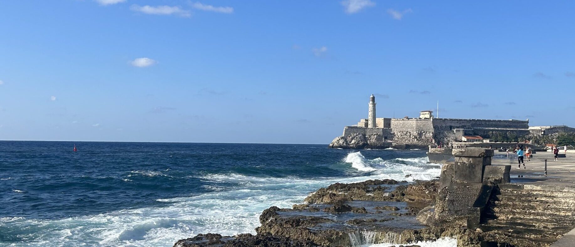
- You will be sailing near the shore of Cuba – you need permission to do so it’s a 180 nm run from Marina Hemingway to the Faro Roncali.
- You need to be fully self sufficient in Cuba
- Download the Satellite charts for Cuba – many of the commercial charts are off / wrong – there is no sea tow in Cuba
COUNTRIES
FOR CUBA A US FLAGGED VESSEL WILL NEED THE FOLLOWING
 U.S. Government Permits & Licenses
1 Temporary Sojourn / Export Permit
◦ Issued by the U.S. Department of Commerce under the Export Administration Regulations (EAR).
◦ Required for your vessel to legally leave U.S. territorial waters bound for Cuba US Coast Guard News
2 CG‑3300 Permission to Enter Cuban Waters
◦ A specific permit from the U.S. Coast Guard, per 33 CFR §107 Subpart B.
◦ Required before departure — your vessel may be prevented from even getting underway without it US Coast Guard News
3 OFAC License / Self‑Declaration
◦ Under Cuba Assets Control Regulations (31 CFR 515), you need either:
 A general license (self‑declaration under a qualifying category), or
A specific license from OFAC — typically rare and restrictive
 U.S. Re‑Entry Rules & Security Conditions
• Under a Port Security Advisory (PSA 1‑25) effective April 2, 2025, all vessels returning from Cuba must meet extra security measures
◦ Conduct a full onboard security search before departure from Cuba.
◦ Notify the U.S. Coast Guard (via email, phone, or VHF) 24 hours prior to re‑entry
◦ Atlantic Area USCG.
◦ Report all security measures taken to the Coast Guard Captain of the Port (COTP) at your U.S. arrival location Atlantic Area USCG
◦ Be prepared for possible inspection or boarding by the Coast Guard upon return
FOR CUBA
https://oceanposse.com/cuba
🧭 Cuban Clearance Procedures
• You must clear in upon arrival — obtain a Cuban cruising permit and despacho from Cuban authorities.
• Before departing Cuba, you must clear out with the Guarda Frontera, customs, and immigration — they’ll issue an exit despacho
• Give 24 hours’ notice to departure, if possible
ROUTE OVERVIEW
ROUTE
WINDS
CURRENTS
SWELL AND WAVES
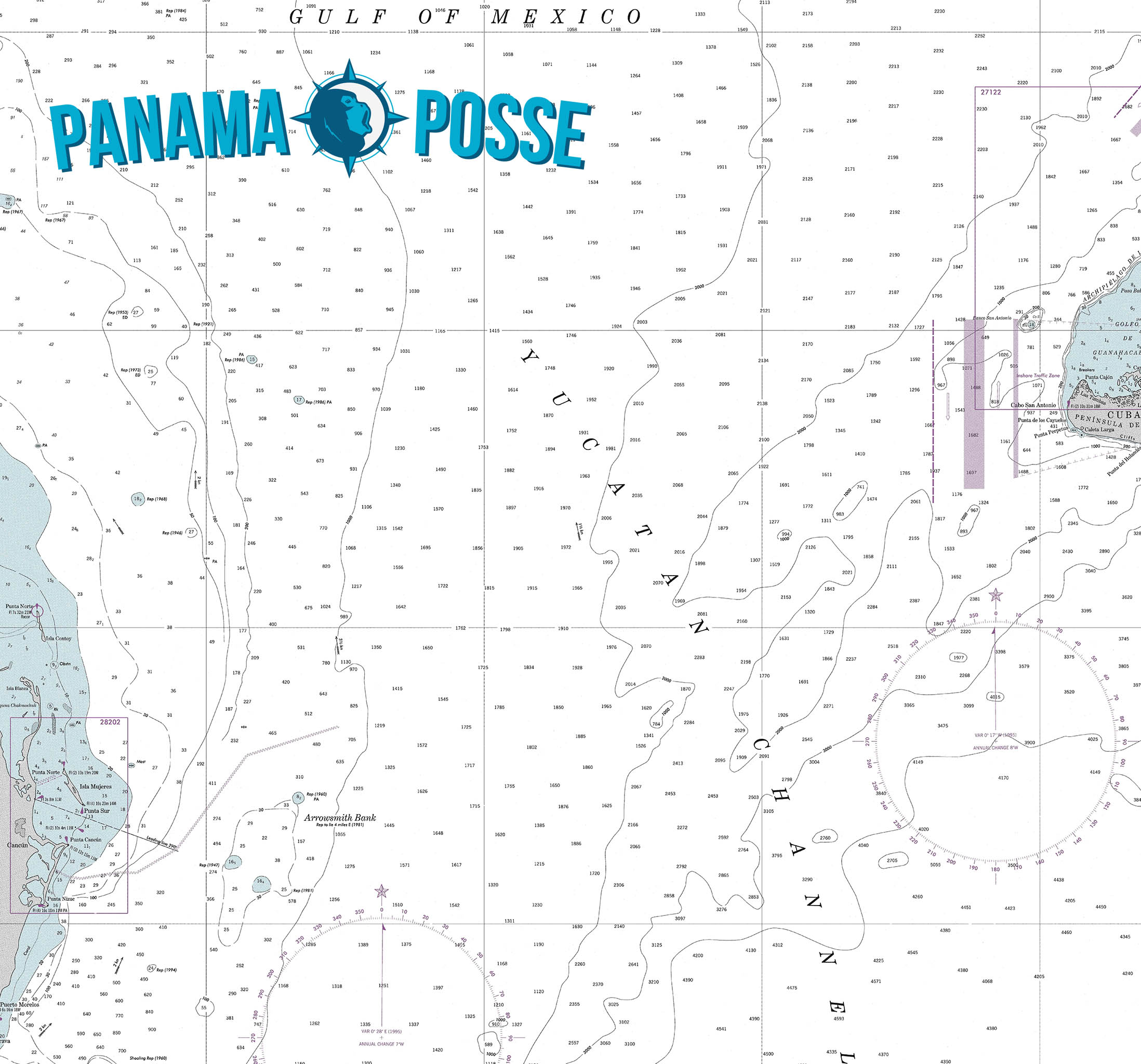
YUCATAN CHANNEL
https://oceanposse.com/yucatan-channel/
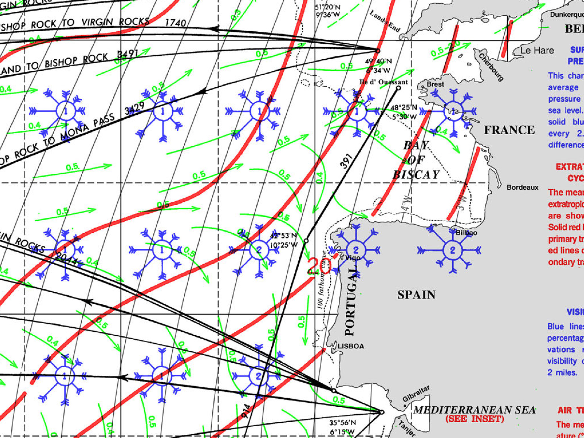
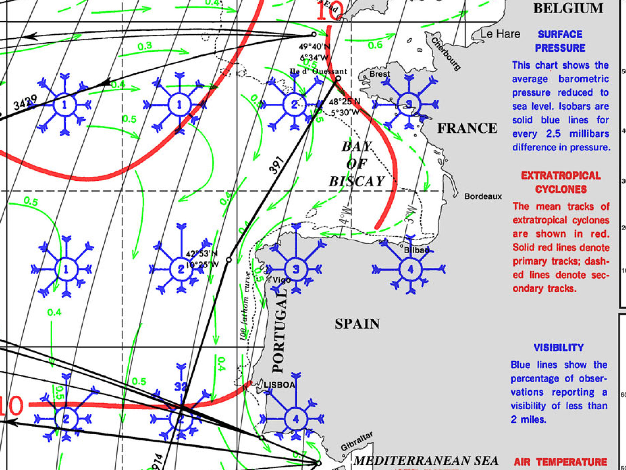
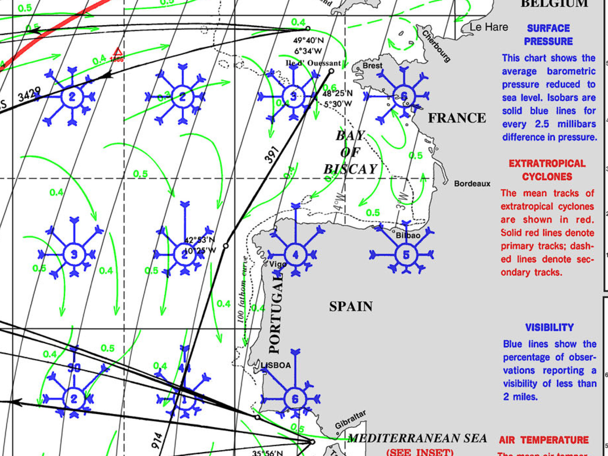
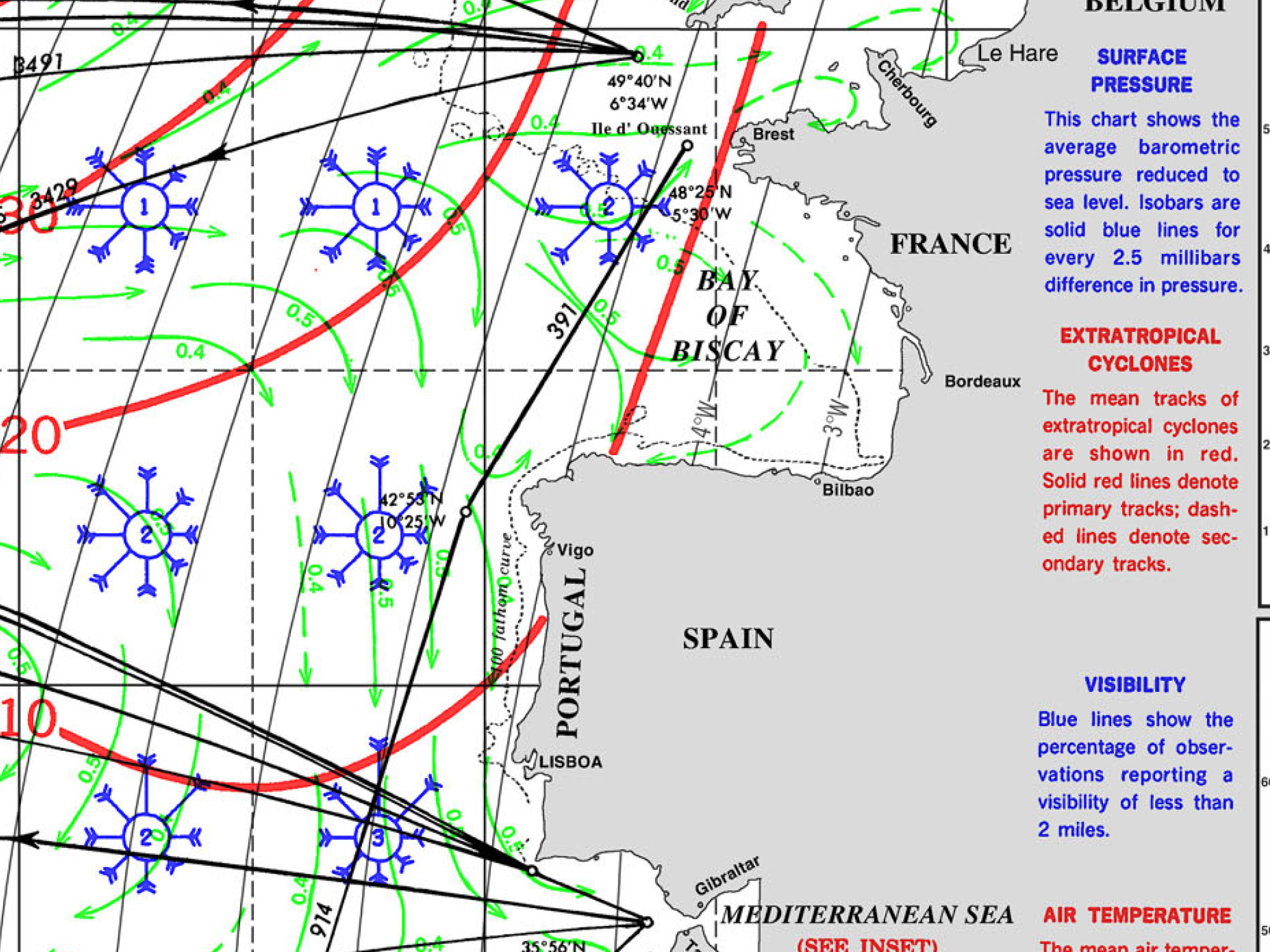
Crossing, Sailing or Cruising the Bay of Biscay with the Ocean Posse
The Bay of Biscay – A Notorious Stretch of Water
The Bay of Biscay, stretching between the rugged northwest coast of Spain and the west coast of France, has a well-earned reputation for being one of the more challenging bodies of water in Western Europe. Long Atlantic swells, unpredictable winds, and sudden weather shifts make this area a passage to be planned with respect and precision. For sailors making their way from the English Channel to Spain or Portugal—or further afield to the Mediterranean—understanding the best time to cross can make the difference between an exhilarating passage and a punishing ordeal.
Seasonal Overview – When to Go
Spring (March to May)
Spring is often a tempting time for cruisers eager to head south early, but the Bay of Biscay can still deliver winter-like conditions well into April. Low-pressure systems sweeping across the North Atlantic remain frequent, bringing strong westerlies and occasional gales. Sea temperatures are cold, and squally showers are common. However, by late May, the frequency of severe storms decreases, and high-pressure systems begin to dominate, offering calmer windows.
• Pros: Longer daylight hours by May; slightly less yacht traffic; improving weather late in the season.
• Cons: Unpredictable weather systems; residual winter storms; colder sea temperatures.
• Best time in spring: Late May when the Azores High begins to stabilize weather patterns.
Summer (June to August)
Summer is the prime season for crossing the Bay of Biscay. The influence of the Azores High, a semi-permanent high-pressure system, is strongest at this time, generally bringing settled weather, lighter winds, and calmer seas. The prevailing winds tend to be northerly or northwesterly, which favors yachts heading south to Spain and Portugal.
• Pros: Most stable weather, longest daylight hours, calmer sea states, and more predictable conditions.
• Cons: Occasionally light or variable winds may require motoring; fog can appear, especially near the French coast; increased yacht and commercial traffic in busy ports.
• Best time in summer: Late June to mid-August for the highest likelihood of settled conditions.
Autumn (September to November)
Early autumn can still provide good sailing conditions, particularly in September when sea temperatures remain warm and the Azores High may still be in place. However, by late September, the risk of Atlantic depressions increases. October and November mark the transition back to harsher weather, with frequent gales and rough seas.
• Pros: September often offers mild temperatures and relatively settled weather; less busy marinas as summer crowds disperse.
• Cons: Increasing risk of strong lows from mid-September onward; shorter daylight hours; higher likelihood of storms as winter approaches.
• Best time in autumn: First two weeks of September only.
Winter (December to February)
Crossing the Bay of Biscay in winter is generally discouraged for cruising yachts unless absolutely necessary. The Atlantic storm track is at its most active, with frequent gales, strong westerlies, and heavy swells. Even commercial shipping often diverts or delays during intense winter storms.
• Pros: Virtually none for pleasure yachts; only for seasoned offshore sailors with time-critical schedules.
• Cons: Severe weather, long periods of rough seas, short daylight hours, and colder water increasing the risk of hypothermia in emergencies.
Best Practices for Timing Your Passage
- Wait for a Stable High-Pressure System
Look for a clear, established high with at least 3 to 4 days of stable northerly or northwesterly winds. Avoid departing ahead of approaching lows. - Monitor GRIB Files and Forecast Models
Use multiple weather sources such as Météo-France, PassageWeather, and Windy to track pressure systems at least a week ahead. - Choose a 3-4 Day Window
Most Biscay crossings take between 2 and 4 days for cruising yachts. Ensure your chosen weather window extends beyond your estimated passage time. - Depart Early in the Morning
Leaving with first light gives maximum daylight for the first day and allows you to clear coastal headlands before nightfall. - Avoid Lee Shores in Rising Winds
If southwesterlies are forecast, reconsider departure. The Spanish coast can quickly become a dangerous shore in deteriorating weather. - Consider a Night Arrival Plan
If delayed, ensure you are comfortable making landfall in the dark or have alternate ports identified.
Practical Tips for a Comfortable Crossing
• Crew Preparedness: Biscay’s long Atlantic swell can test stomachs. Prepare for seasickness prevention, even in calm conditions.
• Secure Below Decks: Stow gear properly; Biscay can still produce lumpy seas even in good weather.
• Watch Rotations: With long daylight hours in summer, plan watch schedules to maximize rest.
• Fuel and Engine Checks: Expect light winds in high-pressure systems, meaning motoring is common.
Summary – The Best Time to Cross
For most cruisers, late June through mid-August offers the best combination of settled weather, reliable high-pressure systems, and comfortable sea states. Late May and early September can also provide good windows but with slightly higher risks of variable weather. Avoid winter unless you are highly experienced and time-constrained.
By respecting seasonal weather patterns, choosing a stable forecast window, and preparing thoroughly, the Bay of Biscay can be a rewarding gateway—rather than a dreaded obstacle—on your voyage south.
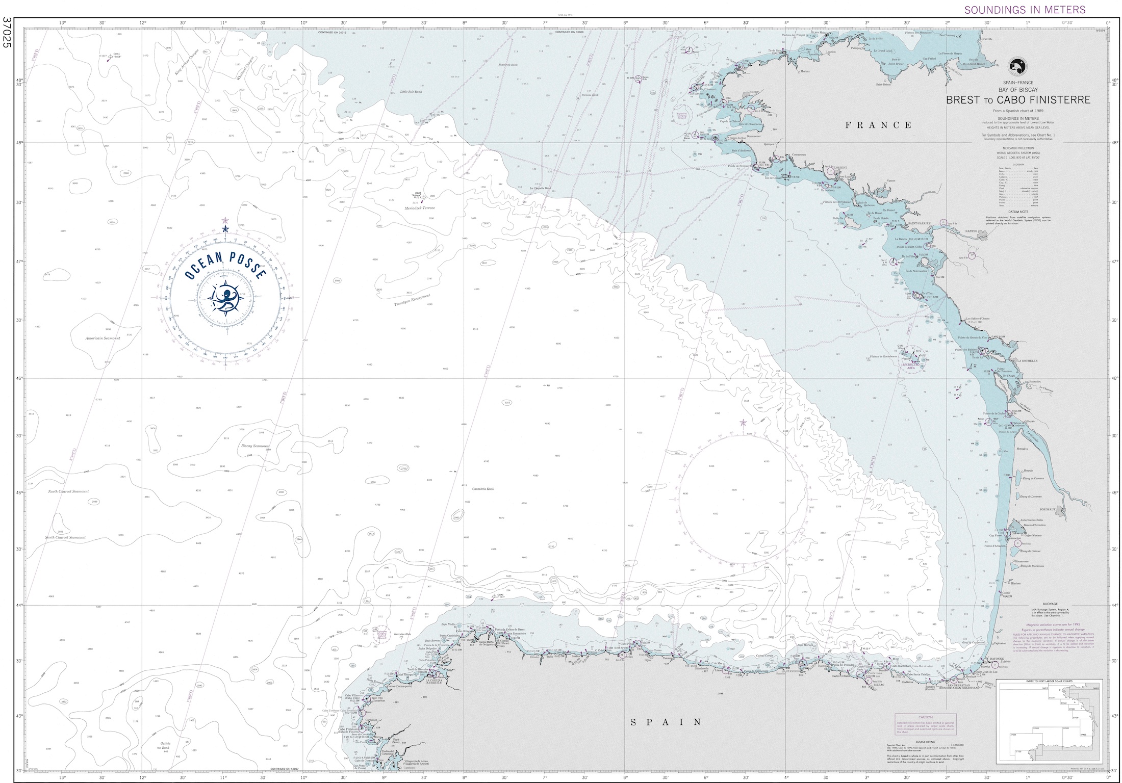
Direct Route
Most crews punch straight south-southwest from a French port, making landfall on Spain’s rugged north coast – A Coruña is the usual target. Expect 2 to 3 nights of continuous sailing, depending on departure point and hull speed. Treat it like what it is – a short ocean leg, not just a coastal hop.
Intermediate Stops
If you’d rather ease into Biscay or need a weather window, you can stage the trip with stopovers. Belle Île works before the jump, or you can aim for Gijón or Viveiro once you’re across – both offer good shelter and solid facilities.
Distance & Reality Check
• Brest to A Coruña, direct: ~360 miles
• Or coastal Route with day hops ( waiting out weather windows )
For many crews, Biscay is the first real offshore test – expect fatigue, seasickness, and the uncomfortable truth that you’re a long way from help if something goes wrong. Prepare like it’s a mini ocean crossing: thorough maintenance beforehand, solid crew briefings, and a realistic plan.
Tactics & Tips
• Time your departure – hit the shelf in settled conditions if you can. A northwest breeze over a leftover southwest swell will build steep, nasty cross seas.
• Daylight crossing over the shelf helps – you’ll see the wave sets (and those wandering fishing boats) coming.
• Best hands on deck for this leg – alert, experienced watchkeepers make the difference.
• In heavy weather, stay west of 7° – crews report a cleaner sea state out there.
BAY OF BISCAY ROUTES
WEATHER
Swell
PILOT CHARTS