

MUST HAVE'S FOR CRUISING TO MEXICO
WHEN STORAGE SPACE IS LIMITTED...
MUST HAVE'S FOR CRUISING TO MEXICO
FOOD
First off, a love of tacos will serve every traveler to Mexico well. Tacos throughout Mexico are tasty, available everywhere every day of the week, affordable, and generally delicious!

Second, know that most markets big and small are very well stocked in Mexico.

Third, some items will be beautifully presented in bulk in covered market spaces.

Over the years more and more people are cruising to Mexico from the north and the south and finding that provisioning in Mexico is overall excellent particularly in larger towns. In most larger coastal towns like Ensenada, Cabo, La Paz, Loreto, Mazatlan, Puerto Vallarta, Manzanillo, etc... there are multiple large competing supermarkets (like Chedraui, Soriana, Walmart, Sam's Club, La Comer...etc), plus many smaller, local markets, and produce stands. In fact, excluding certain specialty foods that you may love in a certain brand (i.e. Jiffy Peanut Butter), most larger towns now have broad specialty provisioning possibilities. That said, as one visits smaller and smaller communities the selection may lessen and in an eye opening way so it is wise to provision well in large communities.
Nonetheless, one can depend on finding food provisions easily throughout Mexico and does not need to arrive in Mexico with their vessel stocked to the gills with a full pantry. Nowadays, some people are filling their hard to reach storage spots with special treats that bring them joy or could be fun gifts to bring others the taste of their homeport. For example, a buddy boat from the Pacific Northwest packed several cases of homepacked salmon to enjoy and give away. With this in mind, people are finding that they are fine to fill their stores with enough food for their passage to their next big port (plus a little) whether it is Ensenada or Chiapas, and save the rest of their storage for other items less easily acquired in Mexico.
BOAT SPARES AND PARTS
Often boats and boat owners are pretty brand and/or quality specific. These types of items may or may not be found easily and locally in Mexico. Often specialty and/or brand specific marine parts need to be ordered in which adds cost and time. For example, our boat has a fair bit of brightwork which we choose to keep up on. That being said, while we have tried many different varnishes and techniques over the years we always load up on the particular material we are using when and where we can because we stick to one product at a time. Mind you, there is Varnish for sale in Mexico, it just may not be the brand you (or we) are loyal to and, if imported, it may be twice as much. For this reason, many people load their vessel up with spares and boat maintenance materials that they are particularly loyal to.

Additionally, many people head to Mexico with boat projects in mind as labor and yard costs are more affordable in Mexico than in the neighboring USA. For this reason, some people will sail to Mexico with parts they plan to use in a project. Use Storage Space for these specialty parts and products that would otherwise need to be imported. Additionally, as engines and generators are very part specific, many people fill their stores with basic spares and filters for your engine and/or generator.
Equally important to note: Mexico is the land of 'Fix it' not 'Replace it'. To this day I wish I took a picture of a plastic chair we found on an empty beach under the shade of a beautiful tree. The chair was old, battered, AND laced together with fishing twine continuing to serve its purpose to any and all who pass by. Similarly, things like alternators and starter motors are often torn down, rebuilt, and reimstalled rather than torn out, thrown away, and replaced. The key to success here is a willingness to ask locals and look for the local specialist for whatever repair one needs. Mexico is full of smart, resourceful, and talented people that make and fix things. Understanding and speaking Spanish, and at the very least trying ones best, is a very important tool in ones toolbox when travelling in Mexico.

PERSONAL/HEALTH CARE
Pharmacies are well stocked and widely distributed in Mexico. Many medicines that are controlled in the USA can be bought without prescription in Mexico. Our first aid kit has been easily maintained and readily built up in Mexico.

THOR HEYERDAHL'S KON-TIKI EXPEDITION
UNSOLVED MYSTERIES:
SOLUTIONS WRITTEN IN THE SAND AT LOW TIDE
In spite of living in the age of information, there are many unsolved mysteries in the world yet. These are mysteries that may not ever be solved. Nonetheless, there have always been and will always be people unsettled with not knowing, asking questions, seeking answers, inventing theories, proposing possible solutions, and testing ideas. The question of human migration is one such mystery shrouded in many theories that do not all agree thereby leaving the definitive explanation as elusive as sailors plans written in the sand at low tide.

 Luc & Viviane – Fountaine Pajot 42′
 The story of Thor Heyerdahl can be found in books, museums, and in movies. He was born in Norway in 1914 and grew into an inquisitive and adventurous archeologist, geologist, ethnographer. He is most known for proposing, testing, and potentially proving his theory of human migration from South America to Polynesia. He surmised that Polynesia was actually populated from the east by Indigenous South Americans who drifted aboard balsawood rafts across the ocean. He sought to prove his theory by building a balsawood raft, which he named Kon-Tiki, lashing it together with natural materials as it may have been, setting out to sea, and drifting to Polynesia. However, in the spring of 1947, Kon-Tiki, Thor, and her crew put out to sea in search of ocean current that runs west from South America to Polynesia. After 101 days alone at sea, Heyerdahl completed his so-called Kon-Tiki expedition, leaving the world in awe. Kon-Tiki and her crew crashed into the eastern side of the Raroai Atoll in the Tuamotus in French Polynesia. Thor met few scholars who supported this theory of Polynesian settlement stemming from South America then or even now. However, his drift theory has been looked to by some as a testament to oceans as conduits for cultural transmission.

Set among a million shades of blue, a beautiful anchorage and a small monument to the Kon-Tiki expedition can be found on the inside of the Raroia Atoll in the Tuamotus.


WHEN THE HALYARD SKIES OFFSHORE...WHAT DO YOU DO?
WHEN THE HALYARD SKIES OFFSHORE...WHAT DO YOU DO?
On every passage there are sail changes and shifts that go smoothly or even better than expected...and then there are the surprises. Some surprises are more or less demanding than others. Our most recent surprise underway gave Captain Mike the opportunity to go up the mast in the middle of the ocean under clear blue skies over gentle 2 meter seas.
His thought was, "I'd rather see what it's like now under these conditions in case I have to consider going up the mast in anything else."
Here's what happened:
Last week, we sailed from the Marquesas to the Tuamotus. Conditions were excellent; we decided to go dead downwind and fly our Main and Jib wing and wing. We poled out the jib, adjusted our course, set the main, and put a preventer on it. The boat felt rock solid sliding down waves and sailing at 9-10 knots.

The wind slacked, we shook out the reef and sailed for maybe 5 more minutes before we heard a "floosh" sound and SURPRISE our mainsail lay a limp pile on the boom.

After minimal discussion, Mike went up the mast to retrieve the halyard. He used his ascenders on one of our spinnaker halyards and we backed it up with our second headsail halyard. At the second spreaders we swapped and he was raised the rest of the way on the headsail halyard and the spinnaker halyard was his backup. Now with all these halyards, where is the backup main halyard? THAT and a backup mizzen halyard are now on our list. Had we had a backup main halyard we could have waited to ascend the mast on anchor instead of underway. Hindsight is indeed 20:20!

Once down with the skied halyard, we found that the shackle had opened, the main twisted out, and bent the shackle arms open. We fixed that, reattached the halyard to the sail, raised the main.
Mike's Take-away:
"It was about what I expected. The hardest thing was staying on the mast. I would definitely not want to go up in anything more than that without more in place to make it easier...like maybe some mast steps or a better climbing set-up."
SV WHIRLWIND Mike, Maurisa, Russell, & Josea - Alajuela 48


THANK YOU FOR SHARING YOUR ADVENTURES UNDERWAY
Send our editor your story to editor@oceanposse.com

POSSE PERK: Free aid to navigation 150 Gb OpenCPN satellite charts (mac/pc/android)
POSSE PERK: 🗺️ Free aid to navigation
150 Gb OpenCPN satellite charts (mac/pc/android)
PLUS vetted tracks to safe anchorages

Open CPN is a chartplotter navigation software that allows mariners to upload multiple charts and satellites images that can be overlayed on one another to confirm what one sees (or does not see) with the chart. It is a huge departure from the days of early explorers that navigated by compass, distant accounts, clouds, and stars. Open CPN takes navigating to a whole different level filled with information. Ocean Posse members have access to relavent Open CPN Charts and Files that aid navigation and keep vessels and crews safer on the water. SV Whirlwind used Open CPN above to navigate an entrance through a passage in a reef into an atoll.
They went from this:

To This:


Ocean Posse members have access to Open CPN Charts, tracks, and How to Seminars
STAY SAFE AND NAVIGATE WITH CONFIDENCE
*IMPORTANT OpenCPN Version 5.10.0 was released August 10, 2024*
5.10.0 is a service/maintenance version to 5.8.4.
OpenCPN 5.10.0 series contains some new features and improvements "under the hood". Many of these changes make OpenCPN work even better.
.
Among them are:
- Grib plugin adds direct GRIB file download capability from multiple online resources.
- Enhanced native NMEA2000 network interface capability from numerous third party gateway devices.
- Update core wxWidgets support to wx3.25.
- Full support for Flatpak on virtually all linux distributions, for both x86 and Arm64 architectures.
- Native support for generic Debian linux distributions, particularly plugin system.
- Improved OpenGL graphics support and performance on all platforms.
- Incorporated extensive user feedback to resolve various UI flaws and functional errors.
- Improved embedded User Manual, mirroring evolving online Wiki presentation.
- Improved reliability and stability across all platforms.
It can be downloaded at https://opencpn.org/OpenCPN/info/downloadopencpn.html

Marquesas named UNESCO World Heritage Site

Marquesas named
UNESCO World Heritage Site

According to the World Heritage Convention, The Marquesan Islands were recently named a UNESCO World Heritage Site for its "exceptional testimony to the territorial occupation of the Marquesas archipelago by a human civilization that arrived by sea around the year 1000 CE and developed on these isolated islands between the 10th and the 19th centuries. It is also a hotspot of biodiversity that combines irreplaceable and exceptionally well conserved marine and terrestrial ecosystems. Marked by sharp ridges, impressive peaks and cliffs rising abruptly above the ocean, the landscapes of the archipelago are unparalleled in these tropical latitudes. The archipelago is a major centre of endemism, home to rare and diverse flora, a diversity of emblematic marine species, and one of the most diverse seabird assemblages in the South Pacific. Virtually free from human exploitation, Marquesan waters are among the world’s last marine wilderness areas. The property also includes archaeological sites ranging from monumental dry-stone structures to lithic sculptures and engravings." https://whc.unesco.org/en/list/1707

The ancient Marquesan anthropomorphic sculptures or tiki have received wide attention since they were first noted in 1595. Oral stories of their significance are difficult to come by as many have been lost. The Marquesan language has been all but lost to French in the islands although, presently there are many people trying to study it, use it, and keep it alive. Beginning in 1980's, there have been academic efforts to trace the history of Marquesan language, spirituality, and stone structures. Stylistically the Marquesan stone tiki followed certain social rules with similar characteristics to tattoos and material objects.


MEET THE FLEET: SV GARGOYLE
MEET THE FLEET: SV GARGOYLE
Kevin & Carla

From the moment Kevin and Carla departed Vancouver BC on May 31, 2019, their first “real” goal was to be in Barra de Navidad in time for the 2019 Panama Posse kickoff meeting at the end of November. That first five months and 4,000 + NM set the tone for the crew of SV Gargoyle, a 2011 Beneteau Oceanis 50. Kevin, Carla, along with their two cats, Sam and Dean, have been sailing proudly under a Posse banner of one flavor or another ever since.

2020 highlights included being locked down in Puesta del Sol, Nicaragua with a number of other posse members. Once they were allowed to leave, Gargoyle beat upwind for nine days to the Galapagos to be one of the first yachts post-COVID to be allowed into these magical islands. After two months in paradise with the islands to themselves, it was time to head East for their first Panama Canal transit and a planned May 2021 Atlantic transit. Insert the Omnicom variant into the story and with Portugal telling them they wouldn’t be allowed into the Azores; they made a 180 degree turn back to Panama for canal transit number two. The decision was now to go the other way to the Med, via the Pacific!
Departing from Marina Papagayo in March 2022 with Dietmar wishing us fair winds from the dock, Gargoyle made a 30-day passage to Nuku Hiva, followed by a season cruising French Polynesia and Fiji. Spending cyclone season in New Zealand, they experienced not one but two cyclones. Leary of the Red Sea they decided to ship Gargoyle with Posse Partner Sevenstar Yacht Transport from Auckland to Cork Ireland in May 2023.
After Gargoyle made her 3rd Panama Canal transit, albeit without her crew, what followed was a magical summer in Ireland and Scotland before a late summer run to Spain, Portugal and then the Med. A winter in Tunisia followed by this season’s cruising in Malta, Sicily, Italy, up to Venice, Greece and now where they sit anchored off Bodrum, Turkey. 24 countries, 40,000NM and yes, Sam and Dean are still rocking it with their human crew.


Follow us on....
Instagram https://www.instagram.com/sv_gargoyle/
Facebook https://www.facebook.com/svgargoyle50
YouTube https://www.youtube.com/channel/UCOihVJ744XS4CoB71HixcFw/
Kevin and Carla are always available as well for a call or email exchange with their fellow cruisers. sailinggargoyle@gmail.com
SV GARGOYLE 🇨🇦 Kevin & Carla - Beneteau Oceanis 50
THANK YOU KEVIN & CARLA FOR BEING A PART OF THE POSSE FOR SO MANY YEARS!

GOOD NAUTICAL: BAIE MARQUISIENNE
GOOD NAUTICAL: BAIE MARQUISIENNE
Nuku Hiva, Marquesas
8°54.8555'S, 140°13.4389'W

Baie Marquesienne is on the western facing side of the island of Nuku Hiva. The Trade Winds generally blow from the East or SE; the swell is similar so this anchorage is generally in the lee of the island making the anchorage very calm and surprisingly dry. Since the water is calm, the clarity is pretty good too and there is a nice spot to snorkel on the N side of the anchorage. I saw sharks, dolphins, and lots of very colorful fish among large boulders and small bits of coral here and there. The bay is surrounded by rocky hillsides that appear to be dry with patches of green vegetation where wild goats roam and bleat all day long. A valley winds up into a steep canyon.
The head of the bay is a rather steep too so landing is not really an option. We have four people onboard and were fortunate to have two that wanted to stay onboard and two that wanted to explore. So, we got dropped off on the beach, brought a radio, some water, and headed off into the wild. There is no marked trail to follow but there are waterways (some dry, some running, some rushing) that we followed up and up and up...until we could not go up any more. As we travelled up the valley we found an oasis and a waterfall, wild pigs and goats, many different flowering trees and plenty of shade to stay cool.


https://goodnautical.com/french-polynesia/anchorage/anse-uea-bai-marquisienne


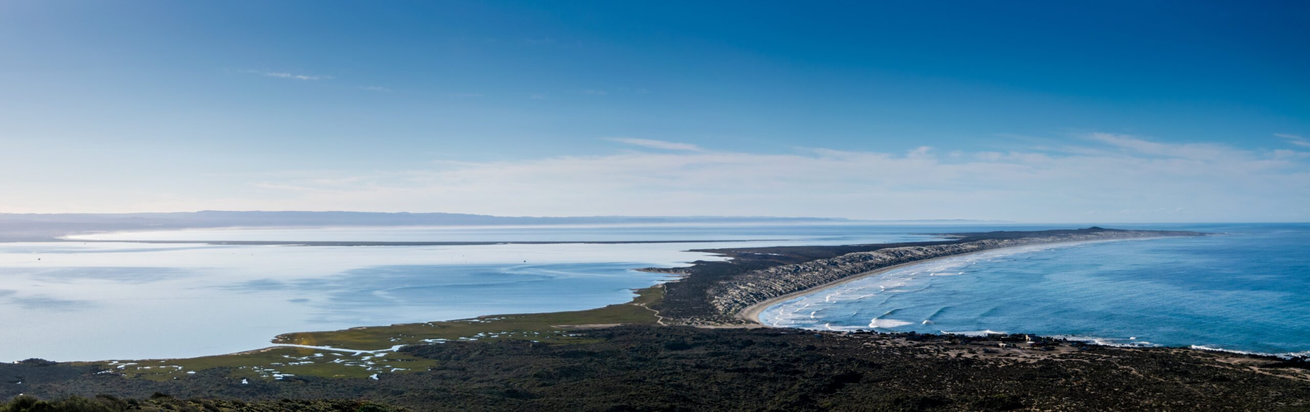
GOOD NAUTICAL ON THE WEST COAST OF THE BAJA: BAHIA SAN QUINTIN
GOOD NAUTICAL ON THE WEST COAST OF THE BAJA:
BAHIA SAN QUINTIN, MEXICO 
30° 23.7384′ N, 115° 55.5760′ W
Posse members on the West Coast are beginning to set their sights on the southbound journey. Consider a stopover in Bahia San Quintin on the west cost of the Baja Peninsula. Whale watching, sport fishing and fantastic seafood bring tourists to San Quintin. Oysters, mussels and abalones are harvested from the crystal clear waters of the bay so please avoid dumping waste of any kind overboard. The lagoon provides great opportunities for dinghy exploration and the remains of an abandoned British colony lie in the shore of the inner bay.

Anchorage
The anchorage on the east side of the bay is open to the SW and feels quite exposed with surf breaking even a mile offshore. Anchor on a sandy bottom in 5-10m just outside the shoal line which is marked by small breakers.
https://goodnautical.com/mexico-pacific/anchorage/bahia-san-quintin
Bahia San Quintin
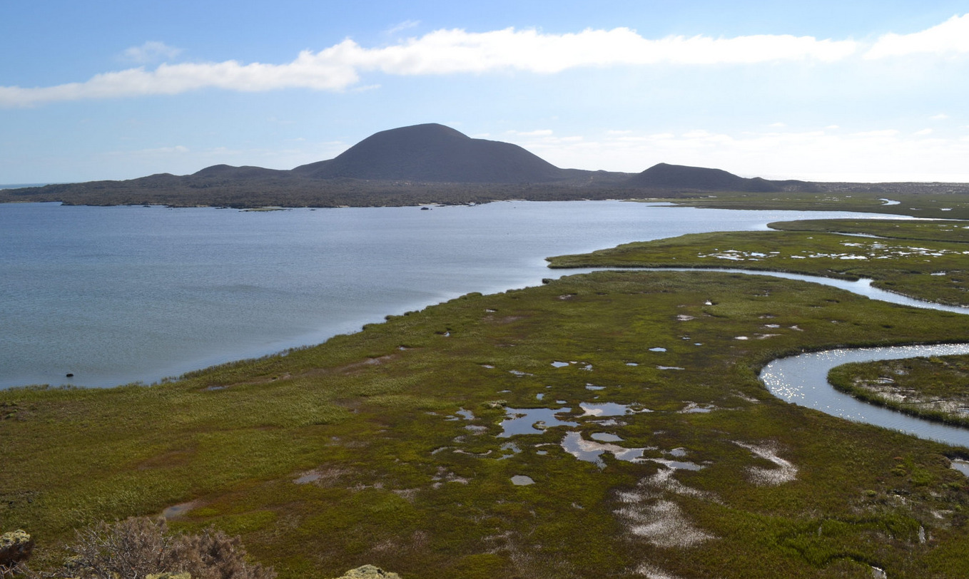
Bahía San Quintín, located on the Pacific coast of Baja California, Mexico, is a hidden gem for sailors seeking an authentic and tranquil maritime adventure. This natural harbor, about 190 nautical miles south of San Diego, offers a unique blend of pristine beauty, rich marine life, and a glimpse into the unspoiled wilderness of Baja California.
Geography and Navigation
Bahía San Quintín is a broad, sheltered bay framed by volcanic hills and sandy beaches, providing excellent protection from the Pacific’s swells. The bay is about 6 miles wide and 11 miles long, offering ample anchorage space with good holding ground in sand and mud. The entrance to the bay can be tricky, especially for first-time visitors, due to shifting sandbars and shallow areas. It is advisable to enter during daylight with good visibility and to use updated nautical charts. Depth sounders and GPS are essential tools for navigating safely into the bay.
Weather and Climate
The climate in Bahía San Quintín is typically mild and dry, with average temperatures ranging from the mid-50s to the mid-70s Fahrenheit. The area enjoys a Mediterranean climate, with dry summers and mild, wet winters. Fog can be a common occurrence, especially in the mornings, so sailors should be prepared for reduced visibility at times. Winds are predominantly from the northwest, providing favorable sailing conditions for those heading south.
Flora and Fauna
Bahía San Quintín is a haven for nature lovers. The bay and its surrounding areas are home to a diverse array of wildlife. Birdwatchers will be delighted by the presence of numerous bird species, including the endangered black brant, as well as various shorebirds and waterfowl. The bay’s waters teem with marine life, making it a popular spot for fishing and snorkeling. Anglers can expect to catch species such as halibut, sea bass, and yellowtail.
Activities and Attractions
For sailors looking to stretch their legs, the area offers plenty of onshore activities. The surrounding landscape is perfect for hiking, with trails leading through volcanic rock formations and coastal dunes. The nearby fishing village of San Quintín provides a glimpse into the local culture and an opportunity to sample fresh seafood, particularly the region’s renowned oysters and clams. Visiting the local oyster farms can be a fascinating experience, offering insights into the aquaculture practices that sustain the local economy.
Services and Facilities
While Bahía San Quintín is relatively undeveloped compared to more popular tourist destinations, it offers essential services for visiting sailors. There are a few basic facilities, including fuel, provisions, and some repair services available in the village of San Quintín. It is advisable to stock up on necessary supplies before arriving, as options may be limited. For those needing more extensive services, the port of Ensenada, located about 130 nautical miles to the north, provides a wider range of amenities, including marinas, chandleries, and professional repair services.
Conservation and Sustainability
Bahía San Quintín is part of a protected natural area, and visitors are encouraged to respect the environment and practice sustainable boating. Efforts to preserve the bay’s natural beauty and biodiversity are ongoing, and sailors can contribute by following Leave No Trace principles, minimizing waste, and avoiding damage to sensitive habitats such as seagrass beds and bird nesting areas.
Conclusion
Bahía San Quintín offers a serene and rewarding destination for sailors looking to explore the less-traveled waters of Baja California. Its natural beauty, abundant wildlife, and tranquil atmosphere make it an ideal spot for those seeking to experience the unspoiled charm of Mexico’s Pacific coast. Whether anchoring in its calm waters, exploring its diverse ecosystems, or engaging with the local community, sailors will find Bahía San Quintín to be a memorable and enriching part of their maritime journey.
Landing on the Beach in High Surf
Landing on the beach in high surf at Bahía San Quintín can be challenging and requires careful planning and execution. The key to a successful landing is timing and understanding the wave patterns. It is essential to observe the surf for a period to identify any lulls between sets of larger waves. When ready, approach the beach at a 90-degree angle, maintaining enough speed to stay ahead of the breaking waves. As you near the shore, reduce speed and be prepared to jump out and pull the dinghy up the beach swiftly to avoid it being swamped by incoming waves. Ensure all equipment and passengers are secure, and wear appropriate safety gear such as life jackets. Landing in high surf can be risky, so if conditions seem too dangerous, it might be best to wait for calmer seas or find a more sheltered landing spot within the bay.
Bahia San Quintin

MEET THE FLEET: SV WINDSONG - Erick & Jenny
MEET THE FLEET: SV WINDSONG
Erick & Jenny

It was a lifelong dream of mine to sail my own boat to beautiful remote places in search of perfect, empty surf breaks, enjoying fishing and other adventures along the way. Around 2007, after my first few years of office work after college, I decided to chase the dream and see if I could make it a reality. Having no prior experience, I took a few sailing lessons to see if it was something I would enjoy and was immediately hooked. Instead of taking a sensible route towards boat ownership, I dove headfirst into buying a derelict project boat and spent the next 10 years fully rebuilding Windsong, a 1975 Downeaster 38 Cutter, into a practically brand new (yet still old) boat. Having little to no relevant skills, I had to learn everything as I went, which in the end gave me a great set of knowledge and experience concerning the ins and outs of the boat.
Once Windsong was as complete as she could be in late 2019, my partner Jenny and I got married, and within a month we moved aboard and set sail for our honeymoon. Leaving from our home port, St. Augustine, FL, and bounced our way down the Florida intercoastal waterway to get a feel for life on the move and at anchor. We started our journey with our senior boxer dog, Koda, who took to cruising life with great happiness as she was able to spend all day, every day with us. After a month or so of Florida coastal cruising, we crossed over to the Bahamas and island hopped for the next few months until Covid shut most of the country down. We sailed back to the US and spent the next summer between South Carolina and Florida. Unfortunately, Koda was not long for the world at this time, so she was put to rest. While it was a devastating moment for us, it did free us up to sail greater distances. We went back to the Bahamas and spent a full season sailing from the Abacos all the way down to Great Inagua. From there we crossed directly to Panama on our first long passage across the Caribbean Sea.

We spent almost two years in Panama, mostly in Bocas Del Toro on the Caribbean side. With great surfing, protected anchorages, affordable living, and fantastic people; it was hard to not stay forever. However, we decided our sailing days were not done, and wanted to cross the Pacific and experience the remote South Pacific tropics. We geared the boat up a bit more, and once all was ready, we first crossed the Panama Canal and set sail to the Galapagos. We applied for and received a 1-year visa for French Polynesia, so after 24 days at sea from the Galapagos we arrived in the Marquesas and then took our time going through the French Polynesian islands, savoring each bit along the way. One year later, we set sail from French Polynesia and with some stops along the way we are now in Fiji, where we will spend the rest of the 2024 cruising season. We do not know where the winds will take us next, but we are looking forward to exploring these lovely islands for as long as they captivate us.


SV WINDSONG  Erick & Jenny - Downeaster Cutter 38′


COSTALEGRE
COSTALEGRE: THE HAPPY COAST
Costalegre translates to the Happy Coast. The 135 nm stretch of coast in Mexico known by this name runs from Cabo Corrientes (the southern limit of Banderas Bay) to Manzanillo. There are 20+ wonderful anchorages along this stretch of coast that make it a fabulous place to cruise. As always, choose your own adventure and take your time to enjoy the most Happiness you can along the Happy Coast. Of course the Panama Posse started in Barra de Navidad and we hope to see you at the kick off event staring Dec 7 - and don't forget to bring your expired flares...
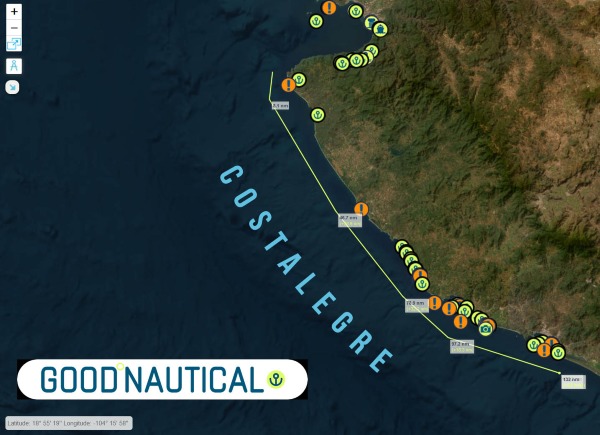 |
With over 30 anchorages the Costalegre is the Panama Posse playground. The water is usually warm and pleasant with gentle dinghy beach landings, Some of these remote anchorages are solitary with the exception of Tenecatitia which at the height of the cruising season will have up to 50 yachts at anchor.
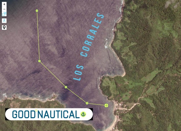 |
⚓ Los Corrales @ 20 246 N 105° 40 W -
(exposed to N - NW & W Swell )
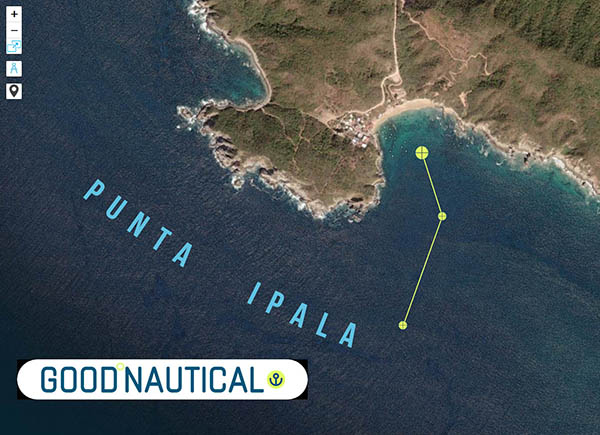 |
⚓ Punta Ipala @ 20° 14.2132' N 105° 34.4000' W
(exposed to W - SW - S Swell )
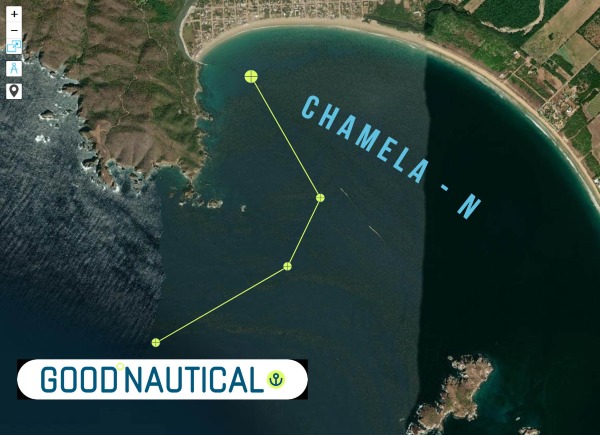 |
⚓ Chamela - N @ 19° 35.0317' N 105° 07.8500' W
(exposed to SW Swell )
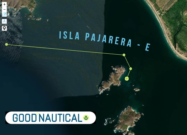 |
Isla Pajarera - E @ 19° 33.5505' N 105° 06.6070' W
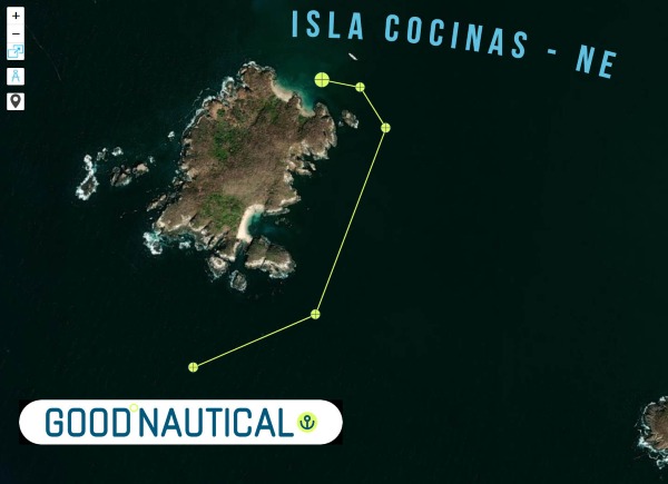 |
Isla Cocinas - NE @ 19° 33.1496' N 105° 06.3817' W
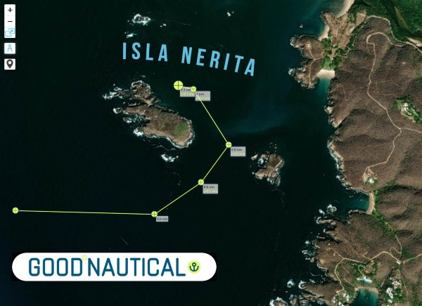 |
Isla Nerita @ 19° 31.4755' N 105° 05.0901' W
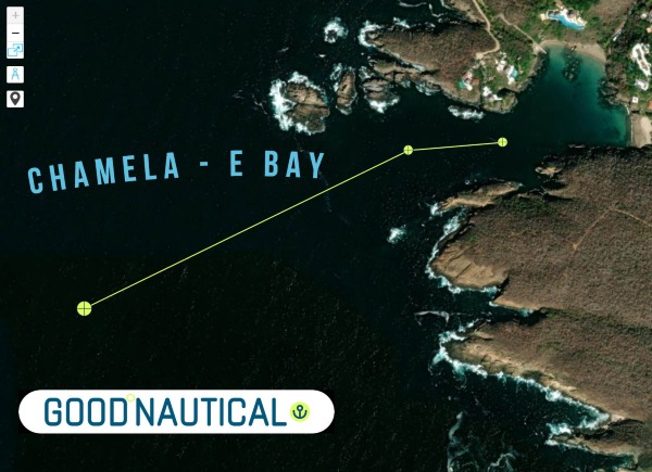 |
Chamela - E Bay @ 19° 30.8433' N 105° 04.8342' W
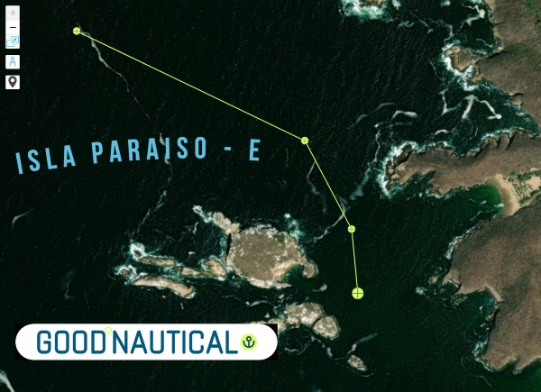 |
Isla Paraiso - E @ 19° 28.6147' N 105° 03.7655' W
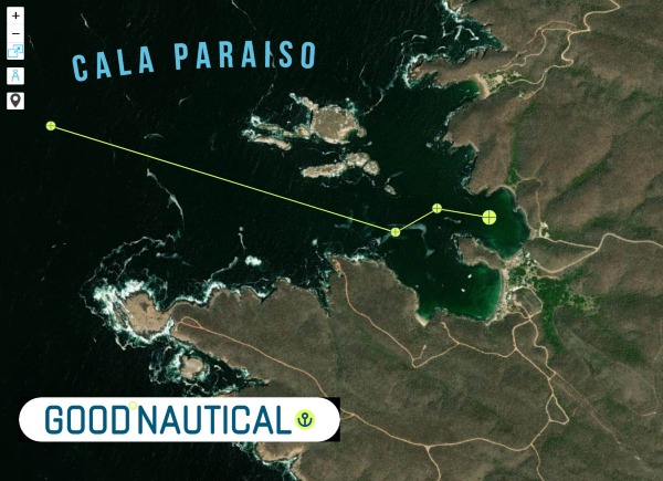 |
Cala Paraiso @ 19° 28.4782' N 105° 03.5512' W
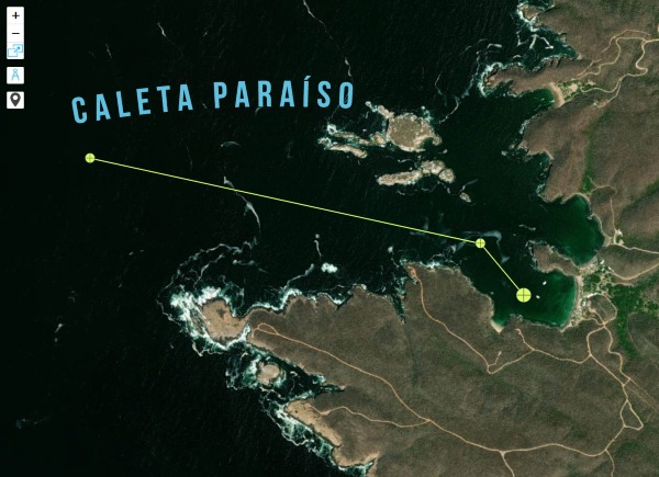 |
Caleta Paraíso @ 19° 28.3383' N 105° 03.6213' W
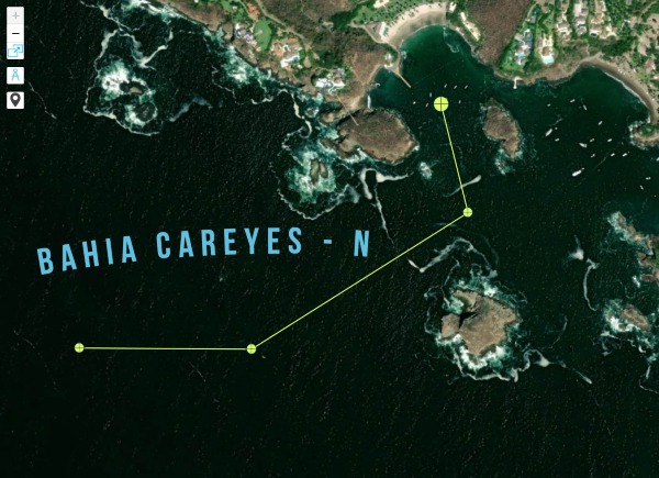 |
Bahia Careyes - N @ 19° 26.6418' N 105° 02.1684' W
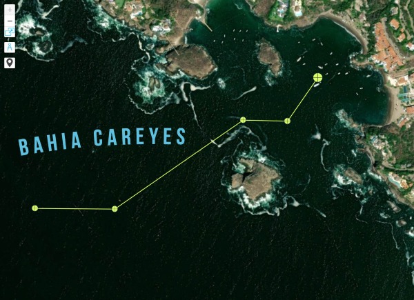 |
Bahia Careyes @ 19° 26.5847' N 105° 02.0021' W
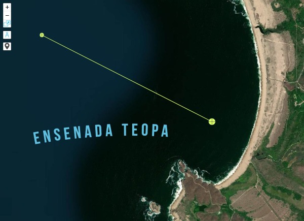 |
Ensenada Teopa @ 19° 23.9448' N 105° 01.4672' W
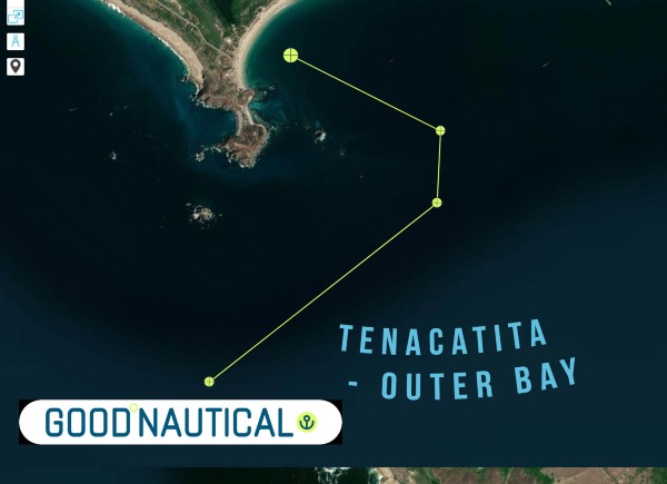 |
Tenacatita - Outer bay @ 19° 17.1346' N 104° 52.0404' W
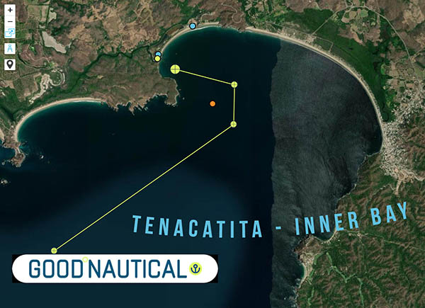 |
Tenacatita - Inner Bay @ 19° 17.8725' N 104° 50.1806' W
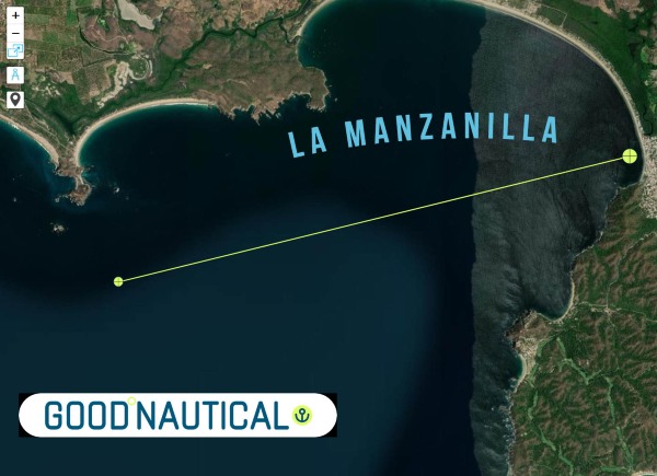 |
La Manzanilla @ 19° 16.8747' N 104° 47.4327' W
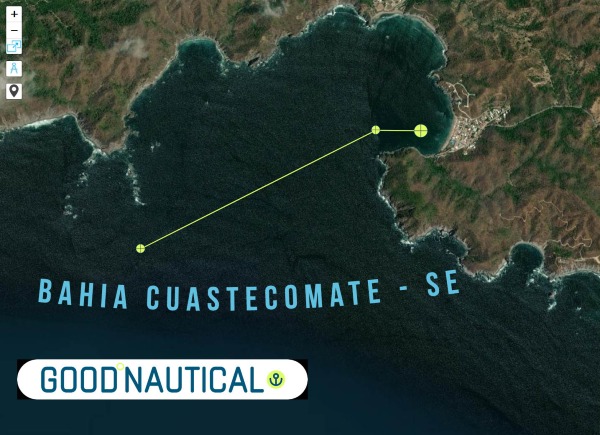 |
Bahia Cuastecomate - SE @ 19° 13.8132' N 104° 43.8949' W
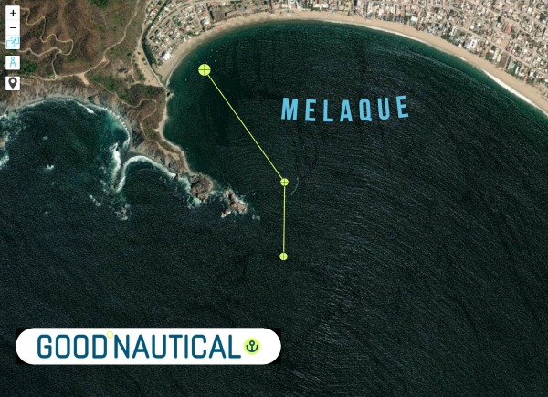 |
Melaque @ 19° 13.1810' N 104° 42.5871' W
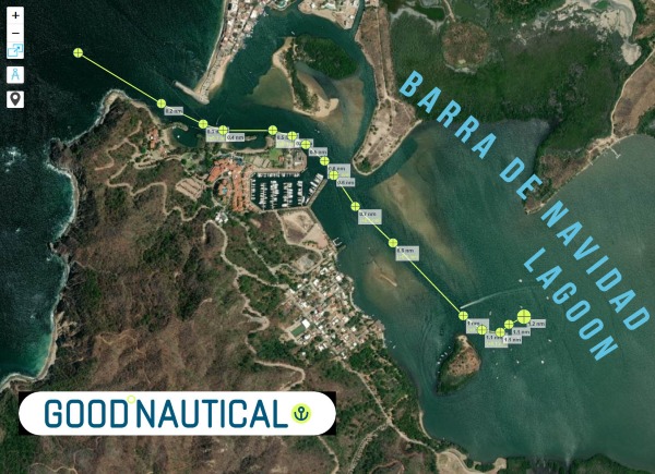 |
Barra de Navidad - Lagoon @ 19° 11.5084' N 104° 40.3672' W
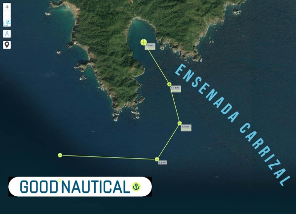 |
Ensenada Carrizal @ 19° 05.7860' N 104° 26.2464' W
 |
Higueras Cove @ 19° 06.2471' N 104° 24.7503' W
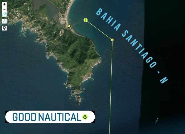 |
Bahia Santiago - N @ 19° 06.6530' N 104° 23.4890' W
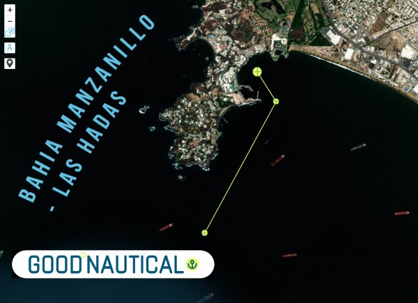 |
Bahia Manzanillo - Las Hadas @ 19° 06.0977' N 104° 20.6284' W
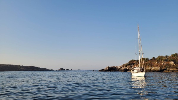 |
SY Seaglub anchored @ Costalegre
| SIGN UP FOR THE OCEAN POSSE |