

SAINT LUCIA 🇱🇨 CRUISING THE CARIBBEAN WITH THE OCEAN POSSE
 SAINT LUCIA
In the heart of the Eastern Caribbean, nestled between Martinique to the north and Saint Vincent to the south, lies the verdant gem of Saint Lucia — a sailor’s isle where the mountains rise like sentinels and the trades whisper tales through the rigging. This Windward island, with her craggy volcanic shoulders, hidden coves, and crescent bays, is a captivating call to all manner of cruising vessels. Here, land and sea hold court in a dramatic interplay — from the twin Pitons that pierce the sky to the quiet rustle of mangroves on the leeward coast.
This is not a land to be rushed. To cruise Saint Lucia is to glide through pages of Caribbean lore — to swing at anchor beneath rainforest-cloaked ridges, to take your sundowner with a backdrop of drumbeats and drifting hibiscus, and to feel the hum of an island that has known buccaneers, sugar barons, and today’s salt-hardened cruisers alike.
APPROACH
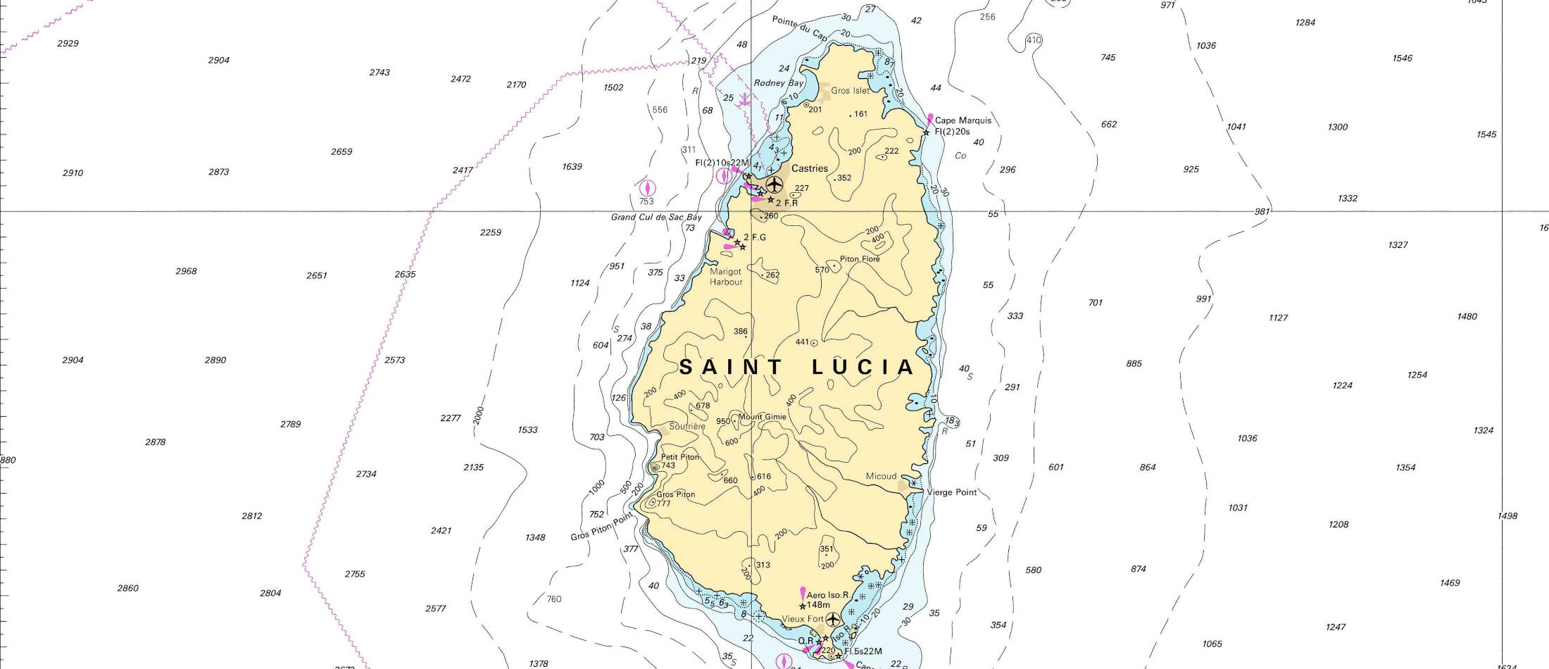
Sailing from the north, many a crew first makes Saint Lucia landfall off Rodney Bay, a generous sweep of beach with the headland of Pigeon Island standing proudly to the northwest. From the sea, the island reveals itself not in subtlety but in grandeur. Volcanic ridges run from north to south, with the interior wrapped in green , towering palms, breadfruit trees, and dense rainforest, all set against the gray-blue profile of the island’s spine.
Approaches to the island are straightforward, with the Atlantic swell pounding the eastern windward shore, rendering it wild and largely unnavigable for anchoring. The western leeward coast, however, is a haven, protected, navigable, and dotted with well-known anchorages, boutique marinas, and fishing villages that carry the soul of the Caribbean in their timbre.
Seasons and Sailing Conditions
Saint Lucia lies within the belt of the Northeast Trade Winds, and its sailing calendar follows the rhythm familiar to all Caribbean mariners:
* High Season (December to April): This is the dry season and the prime time for cruising. Winds are moderate (15–20 knots), skies are clear, and the anchorages are lively. Expect company — Saint Lucia is a favored destination among charter fleets and private cruisers, particularly around holidays and regatta seasons.
* Shoulder Season (May to June): Still favorable for cruising, with calmer seas and fewer boats. A sweet spot for those seeking fair winds and solitude.
* Hurricane Season (July to November): While Saint Lucia lies on the southern edge of the hurricane belt and is statistically less affected than its northern sisters, storms remain a risk. Many yachts either sail south to Grenada or haul out during this time. Squalls and humidity increase from August onward.
Several rallies and many transatlantic yachts arrive in Saint Lucia each December from the Canary Islands and Cape Verde.
Those who remain into late season enjoy quieter bays and local charm, unhurried by the flotillas.
SAINT LUCIA WEATHER
Swell
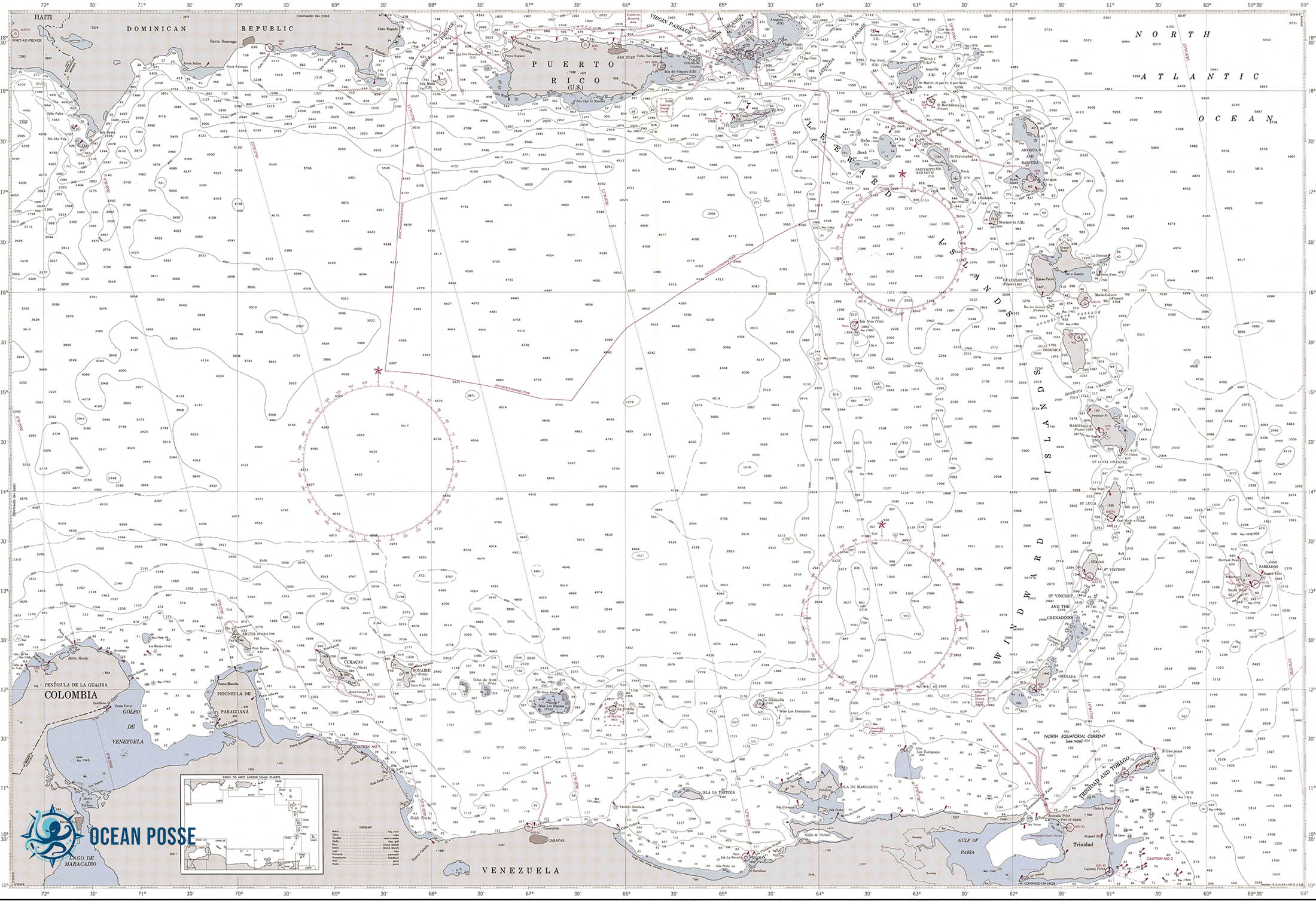
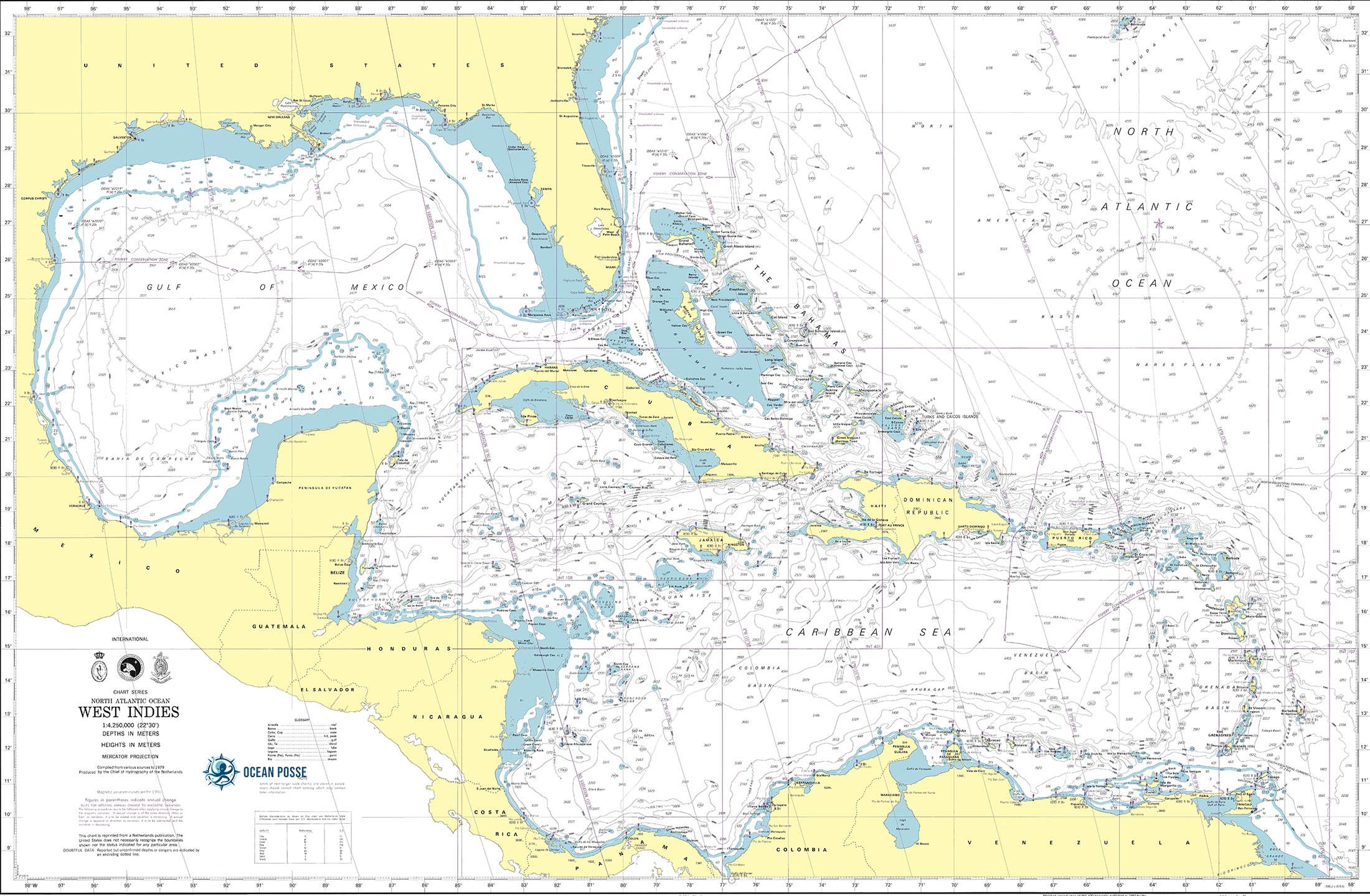
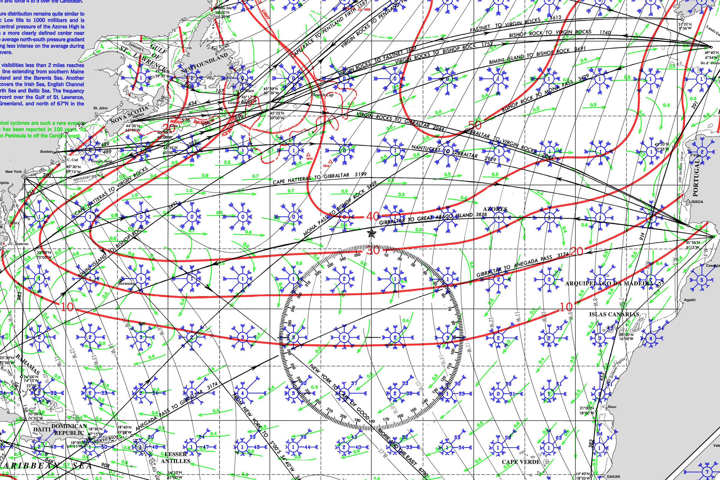
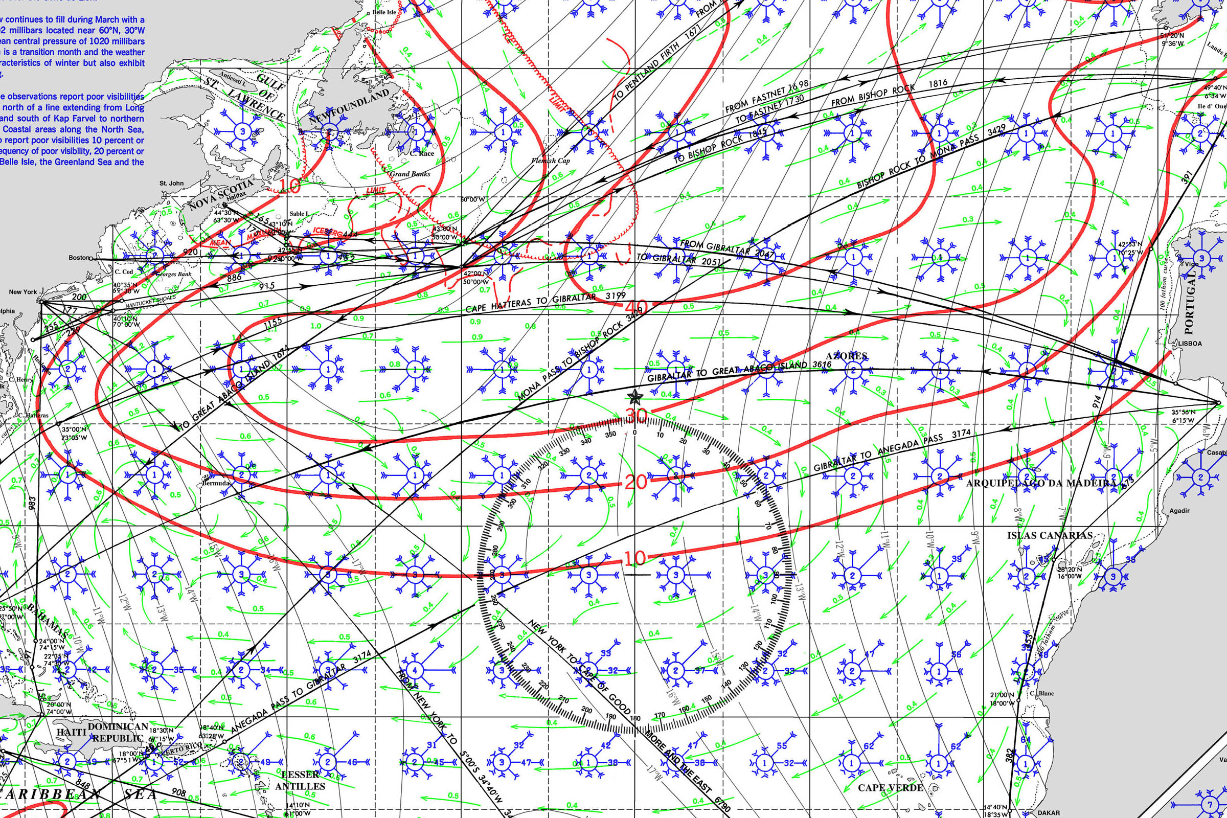
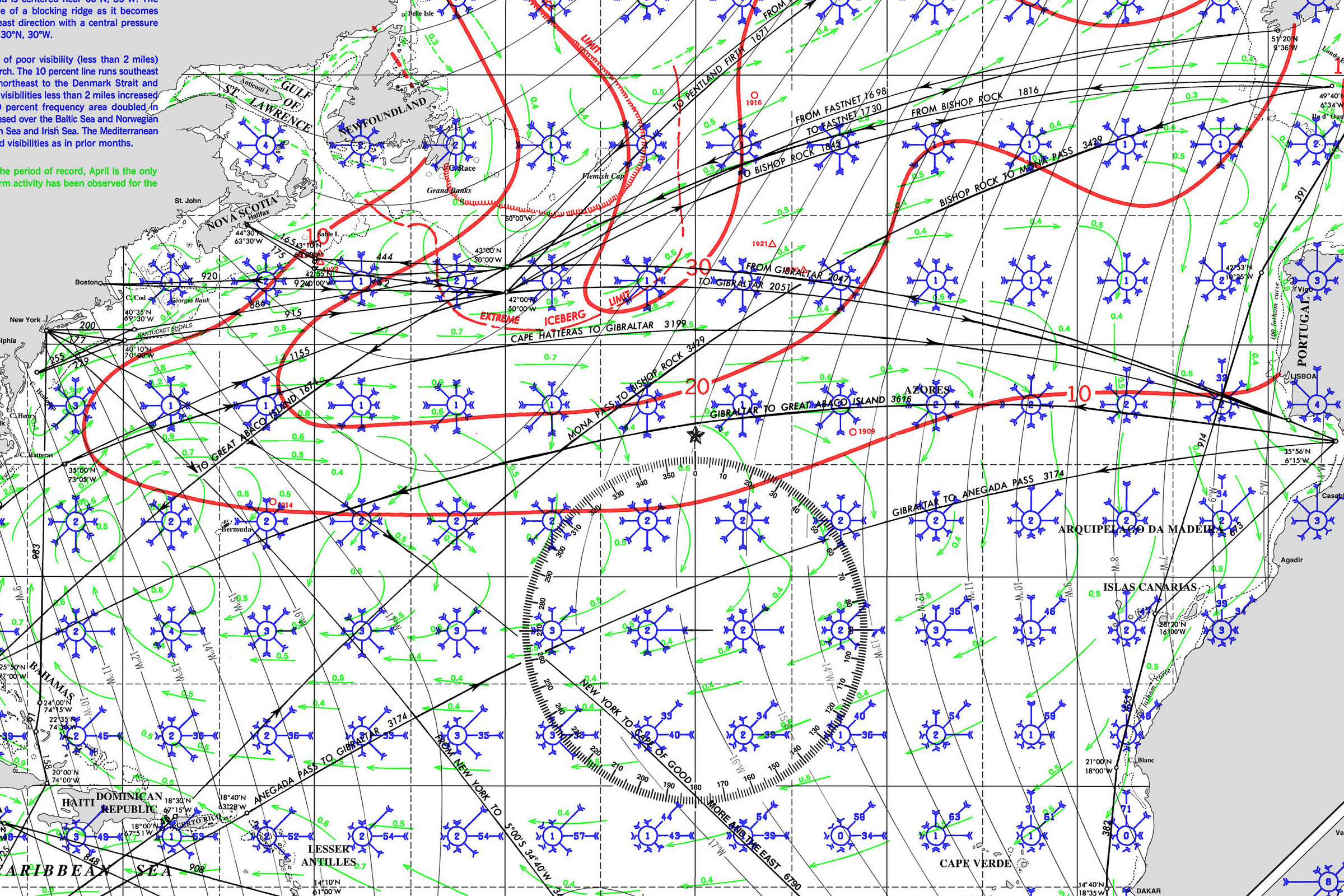
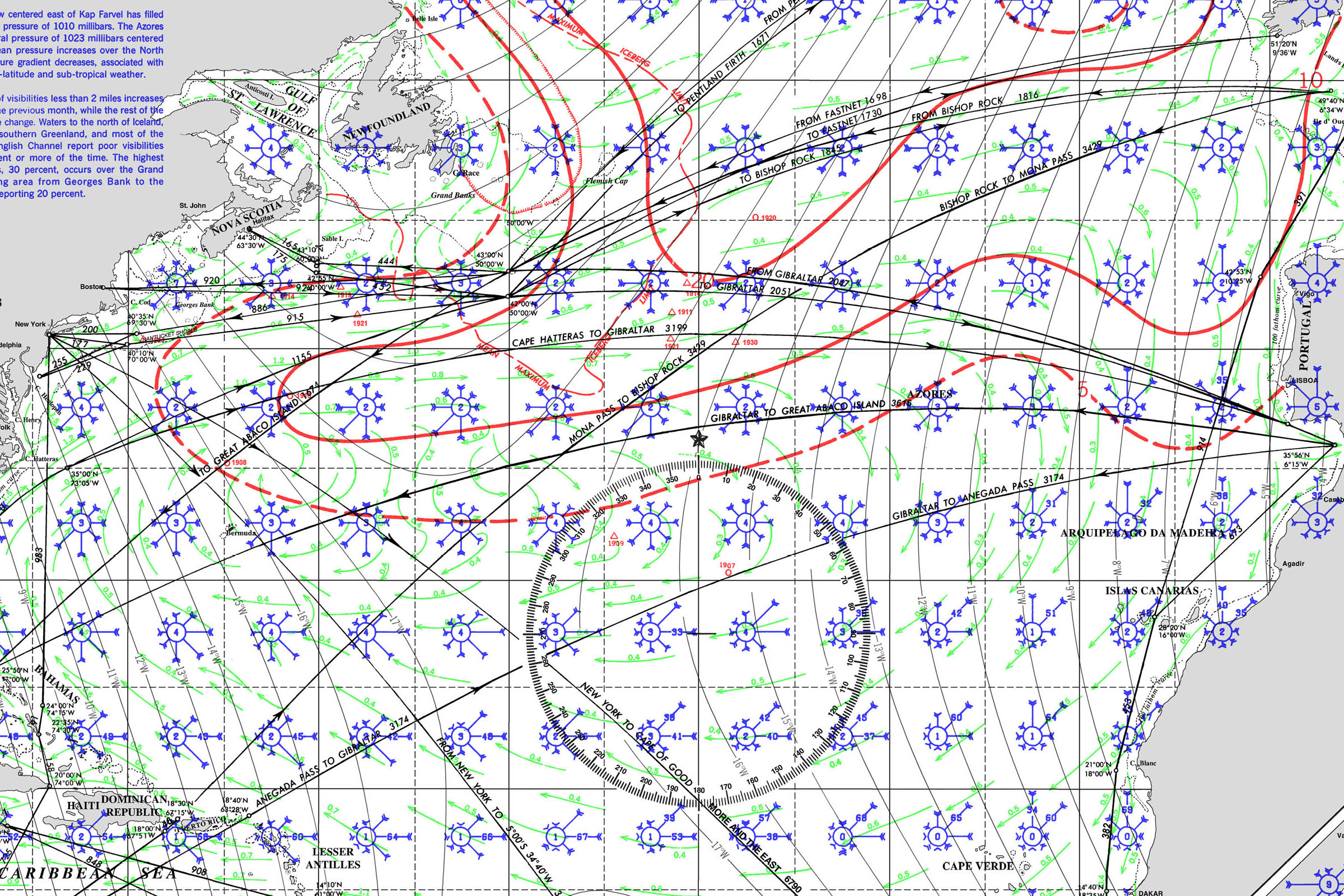
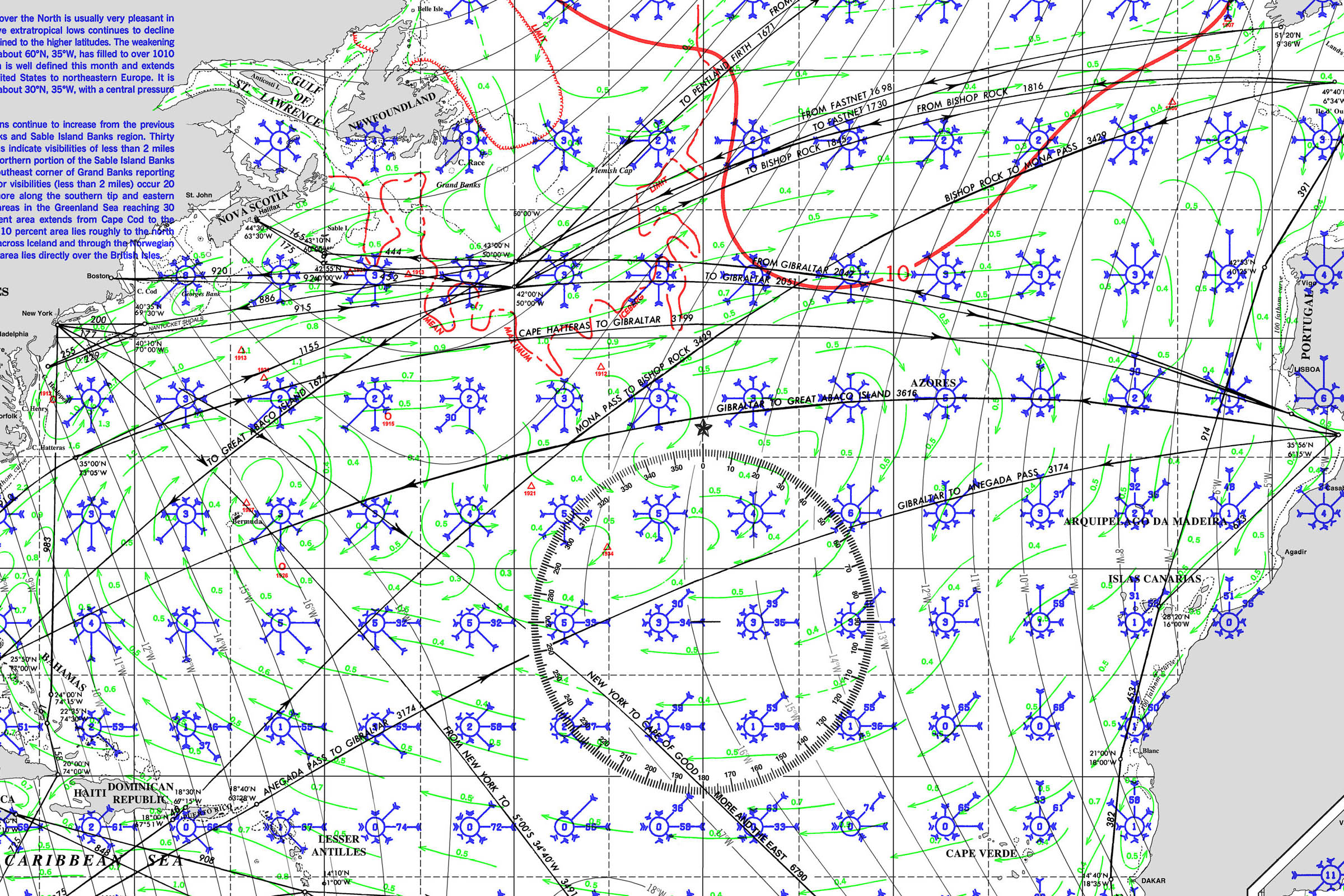
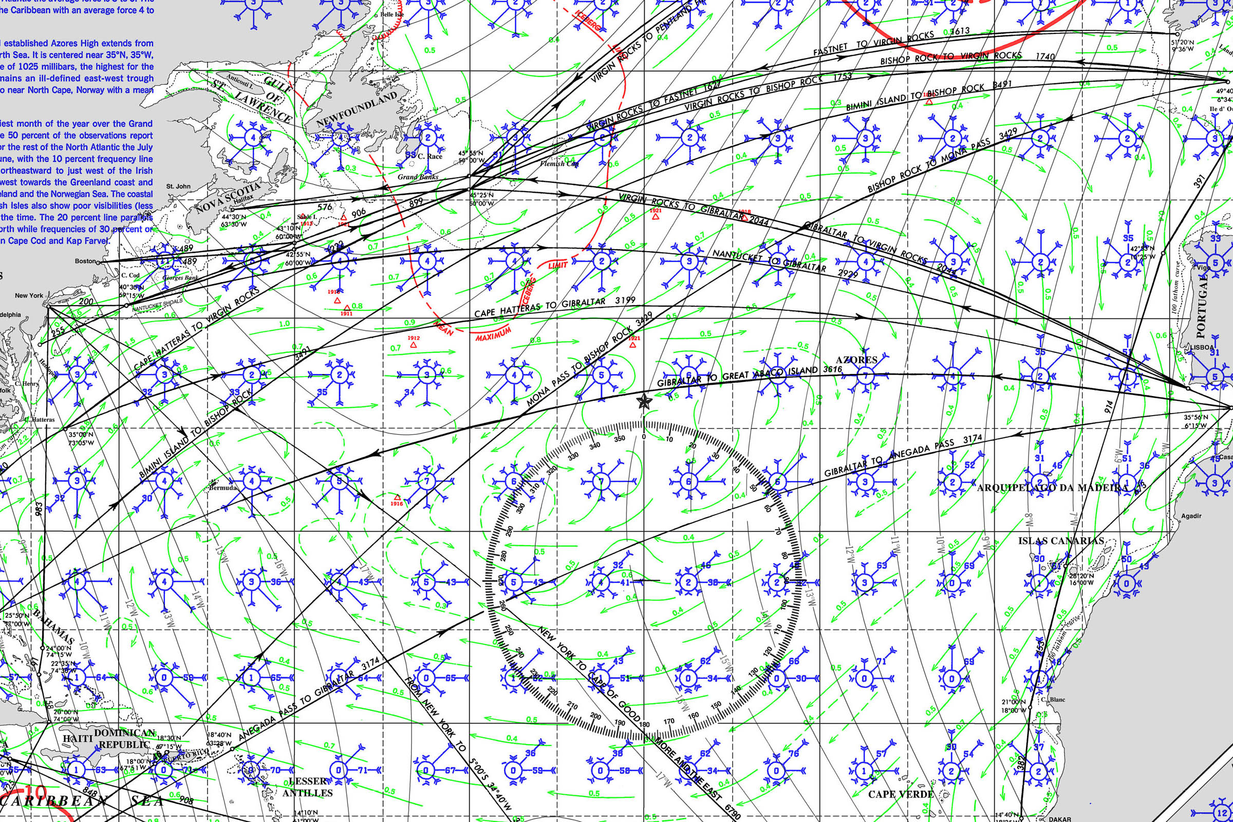
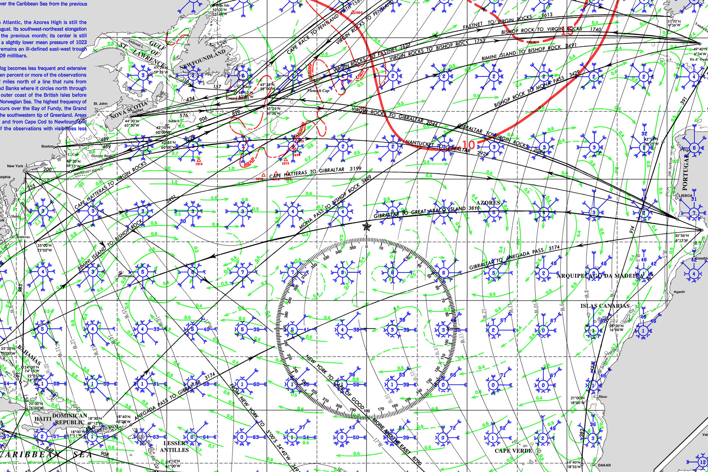
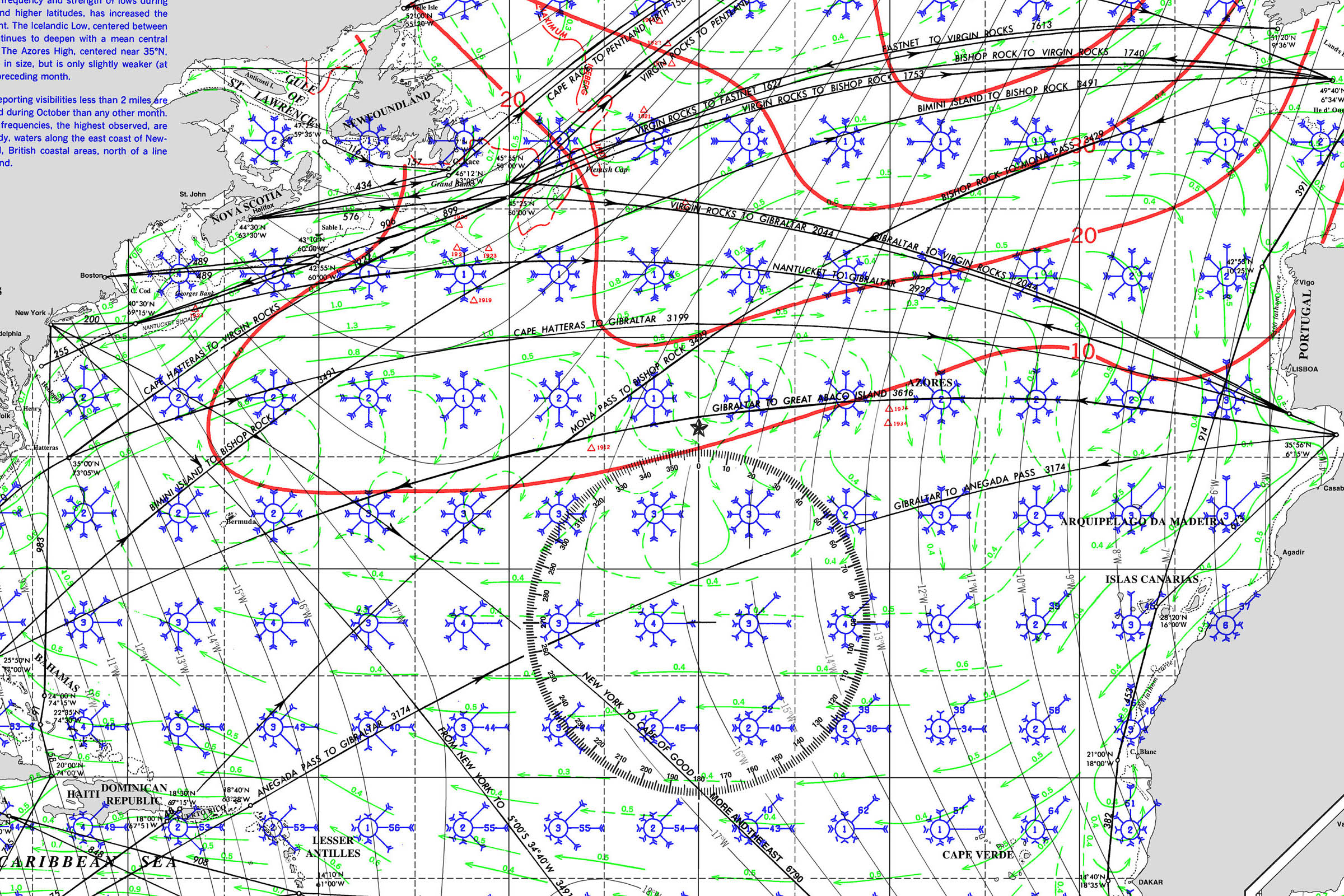
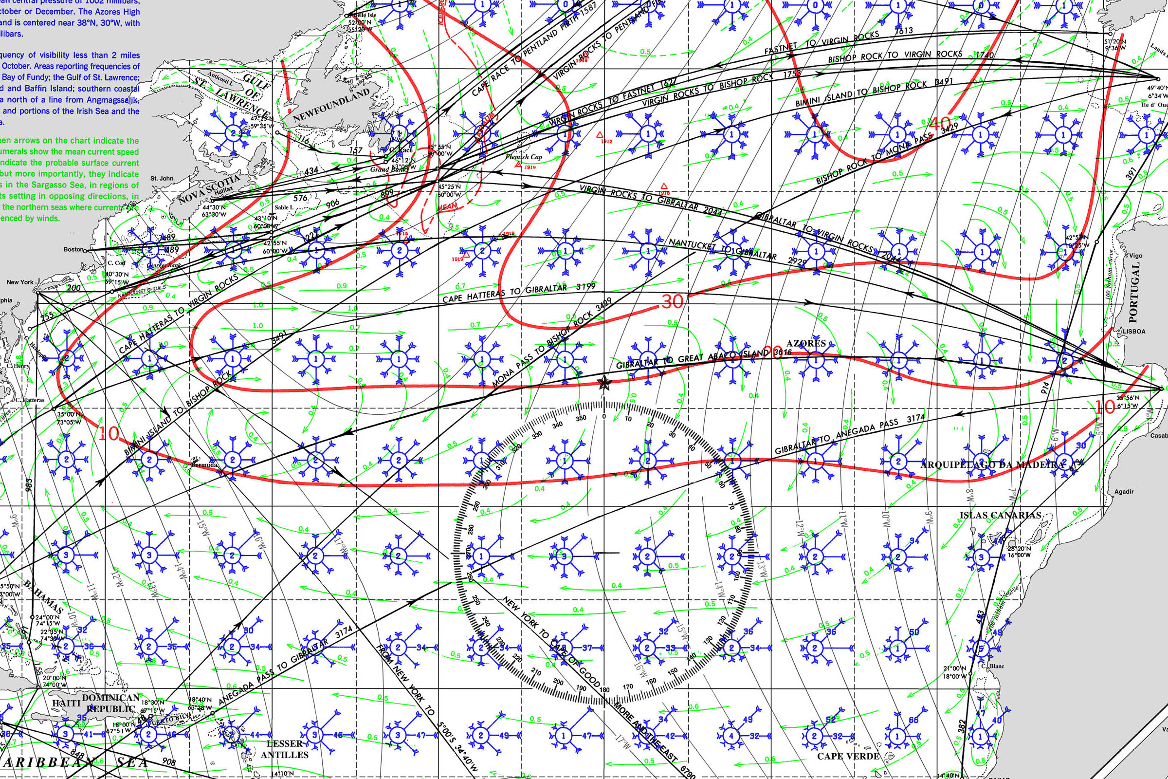
SAINT LUCIA PILOT CHARTS
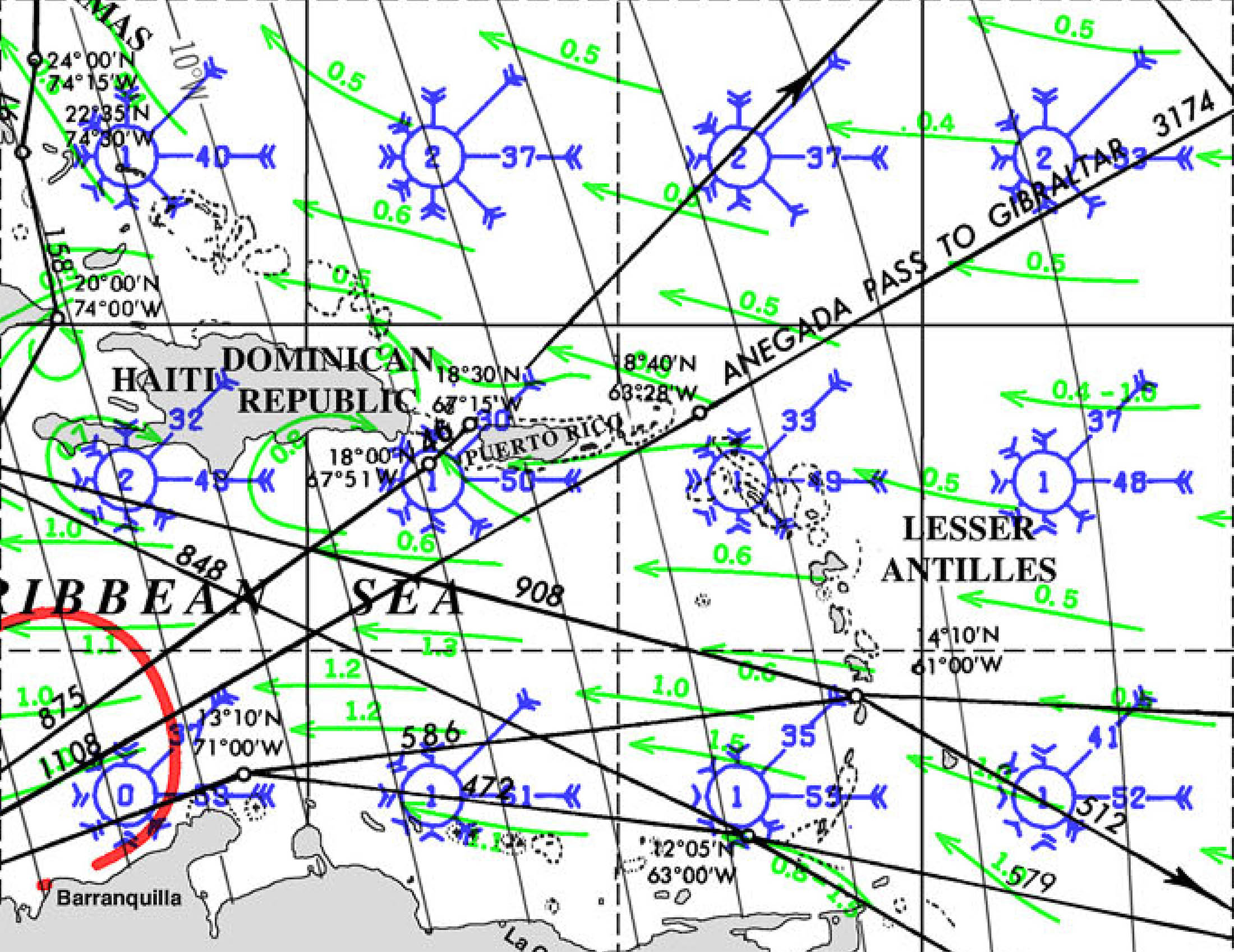
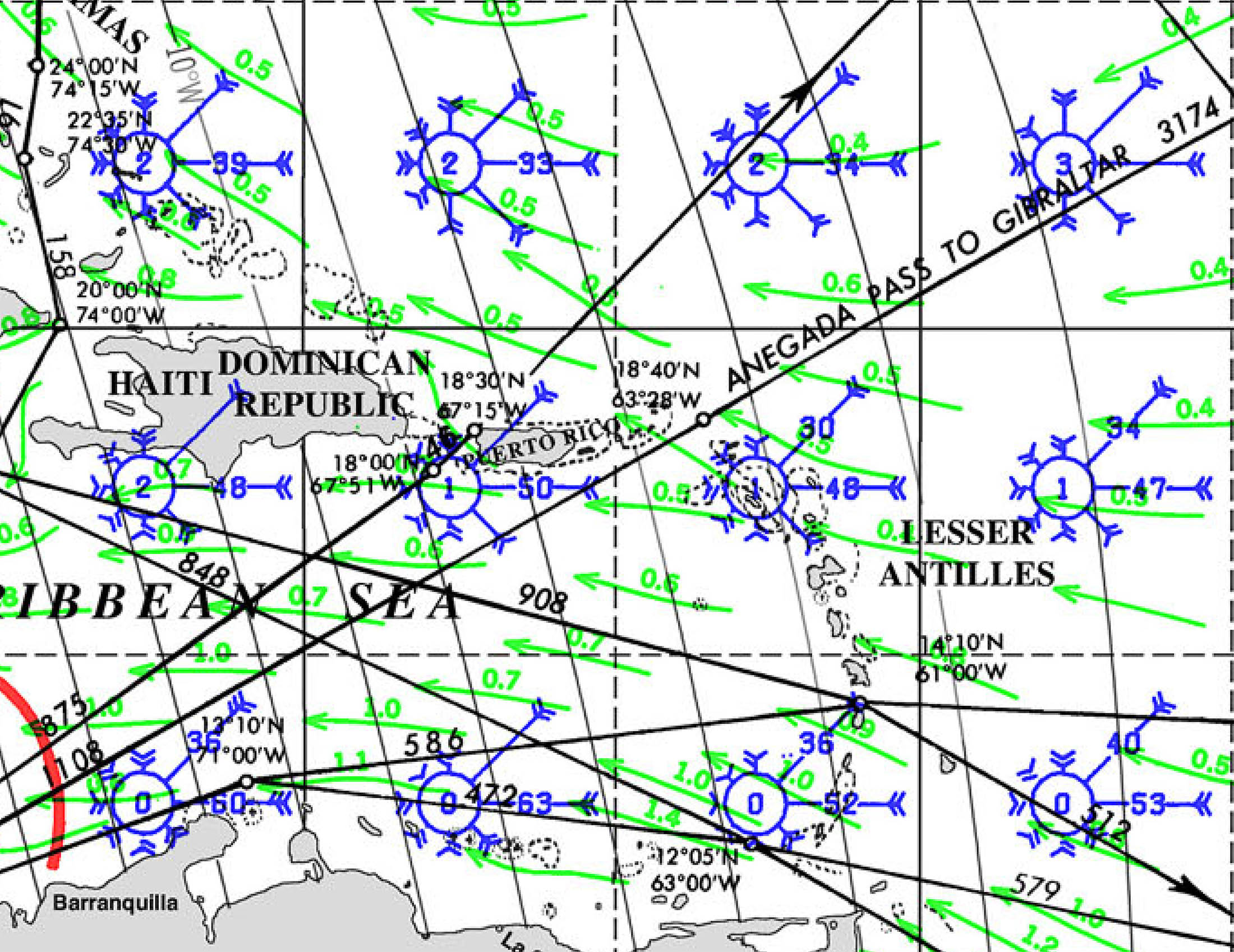
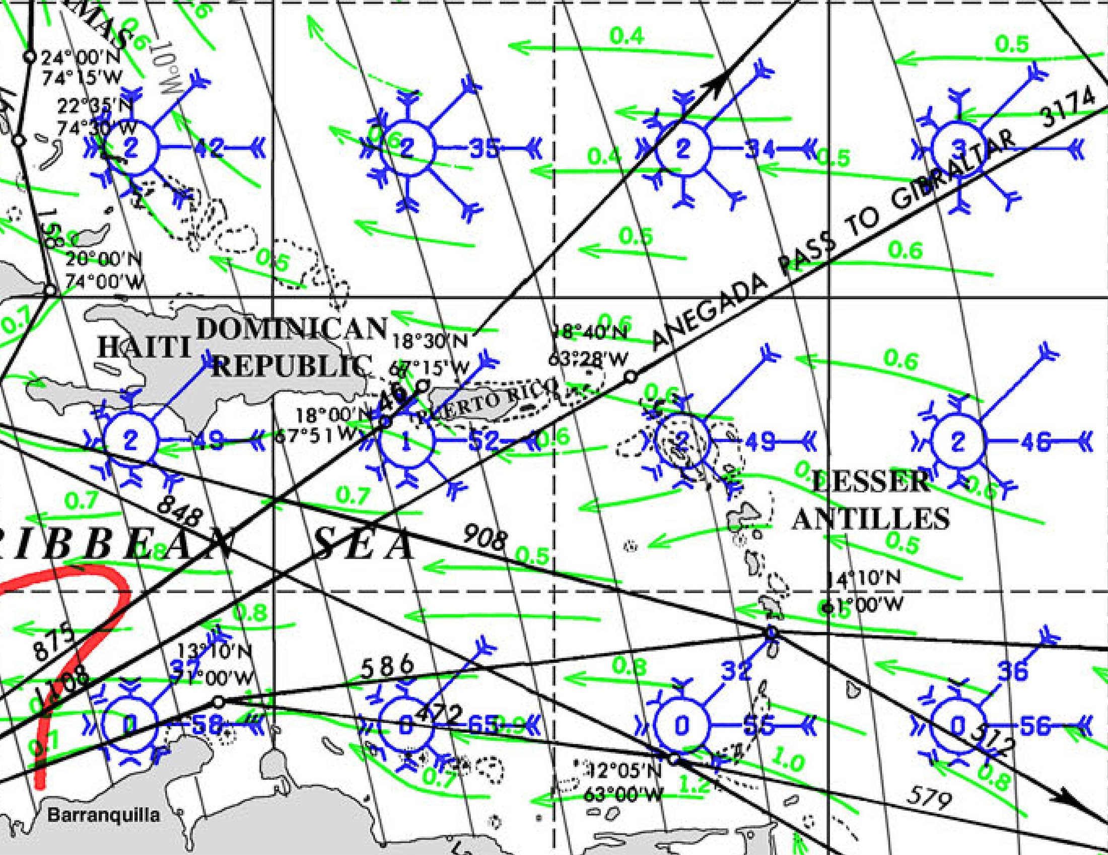
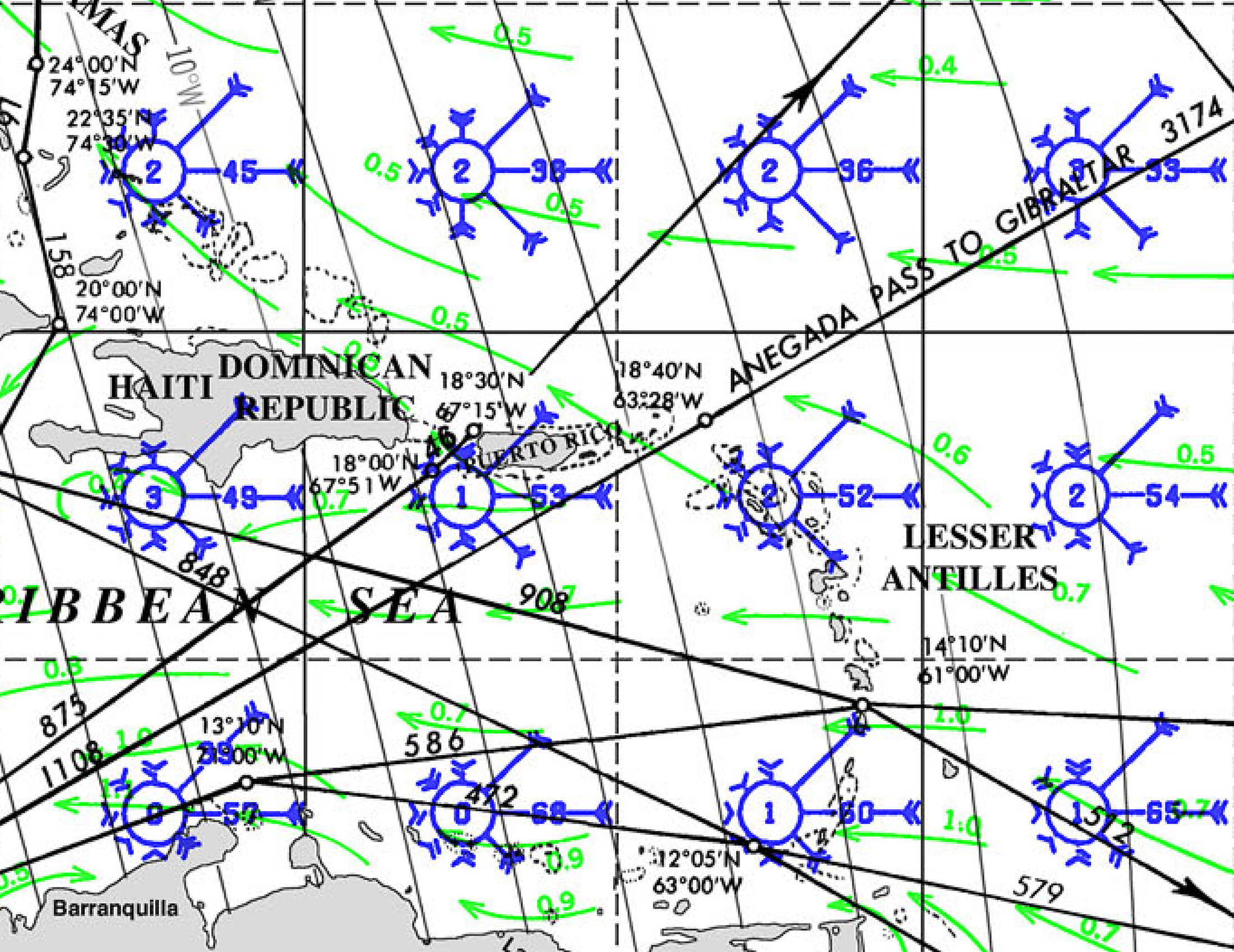
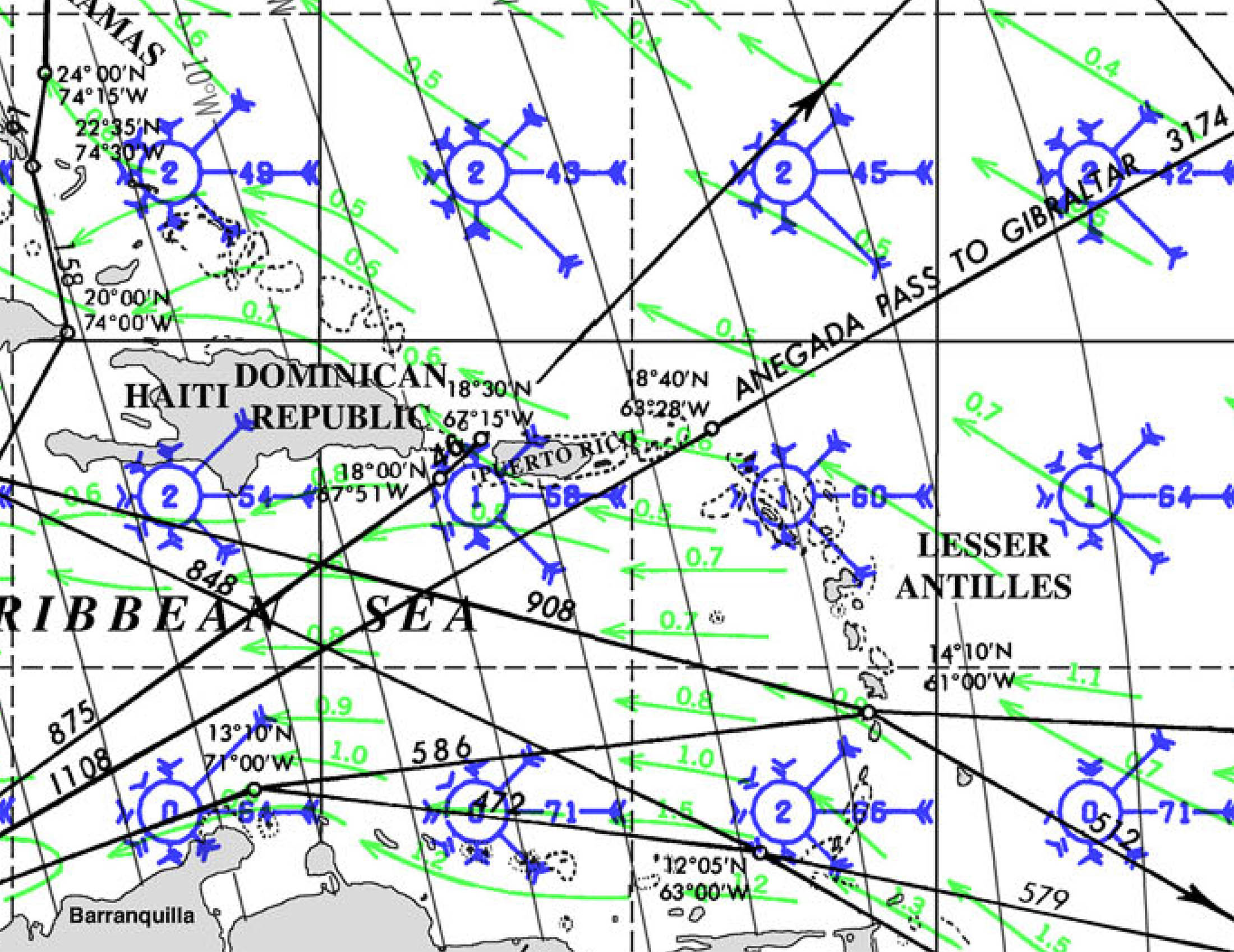
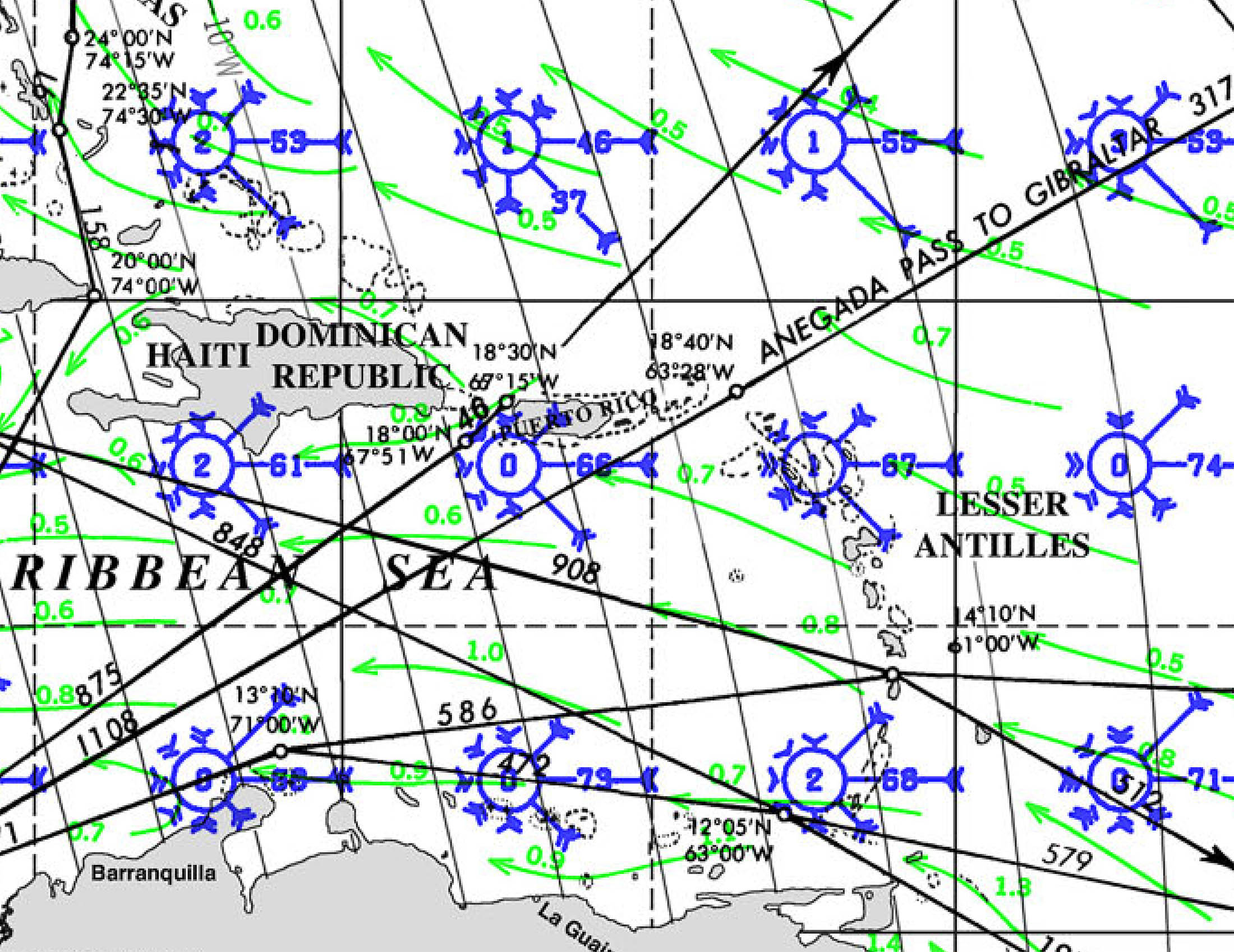
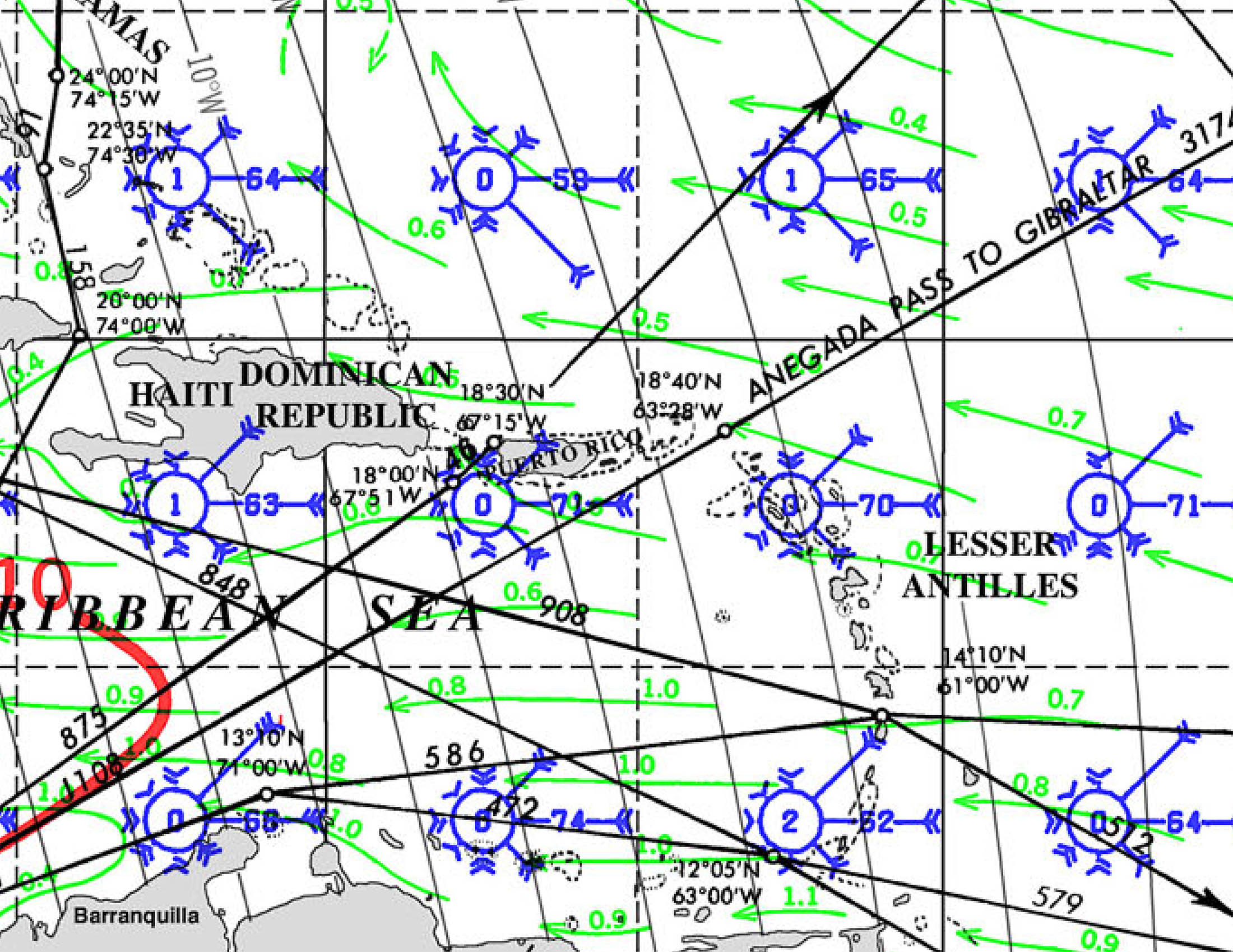
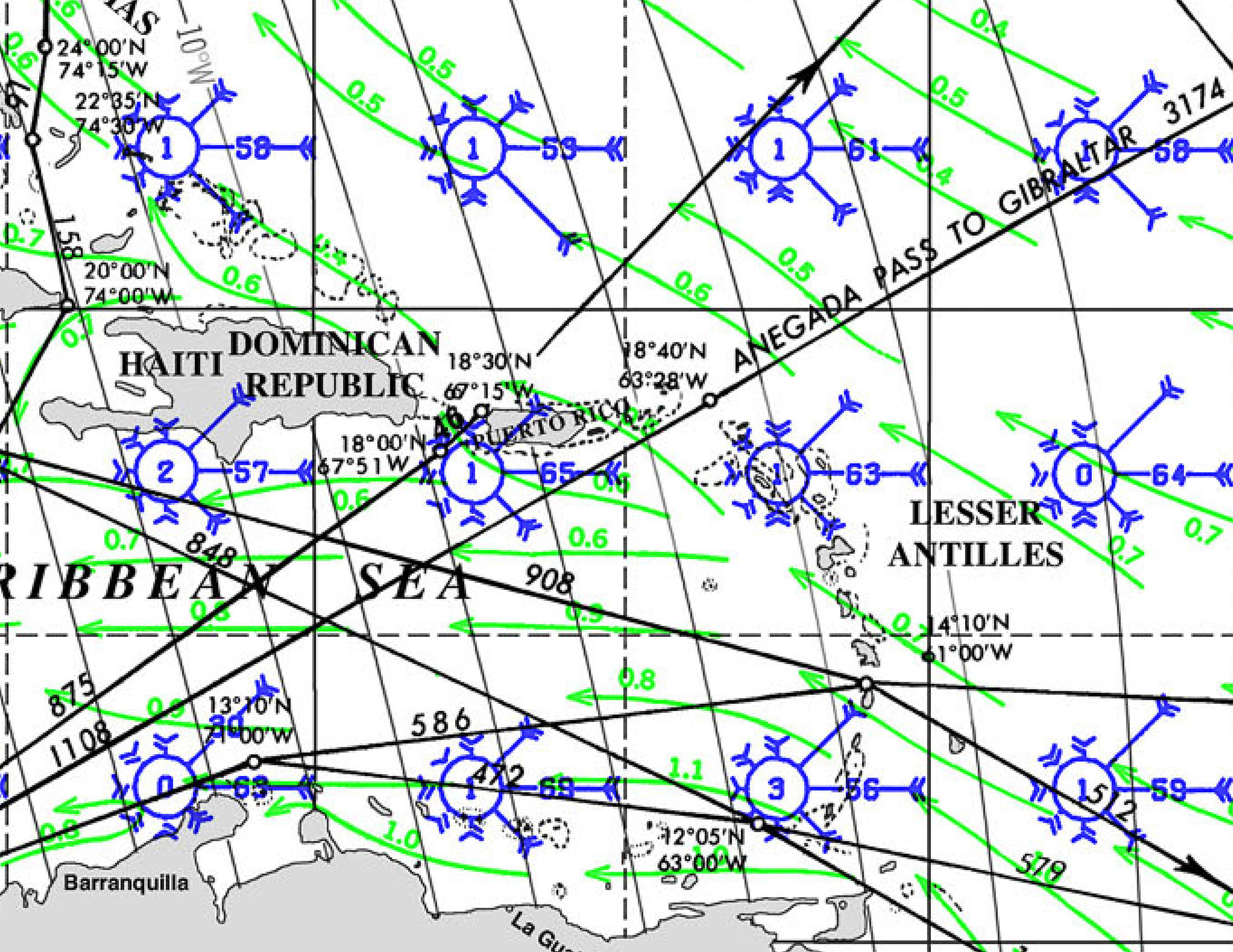
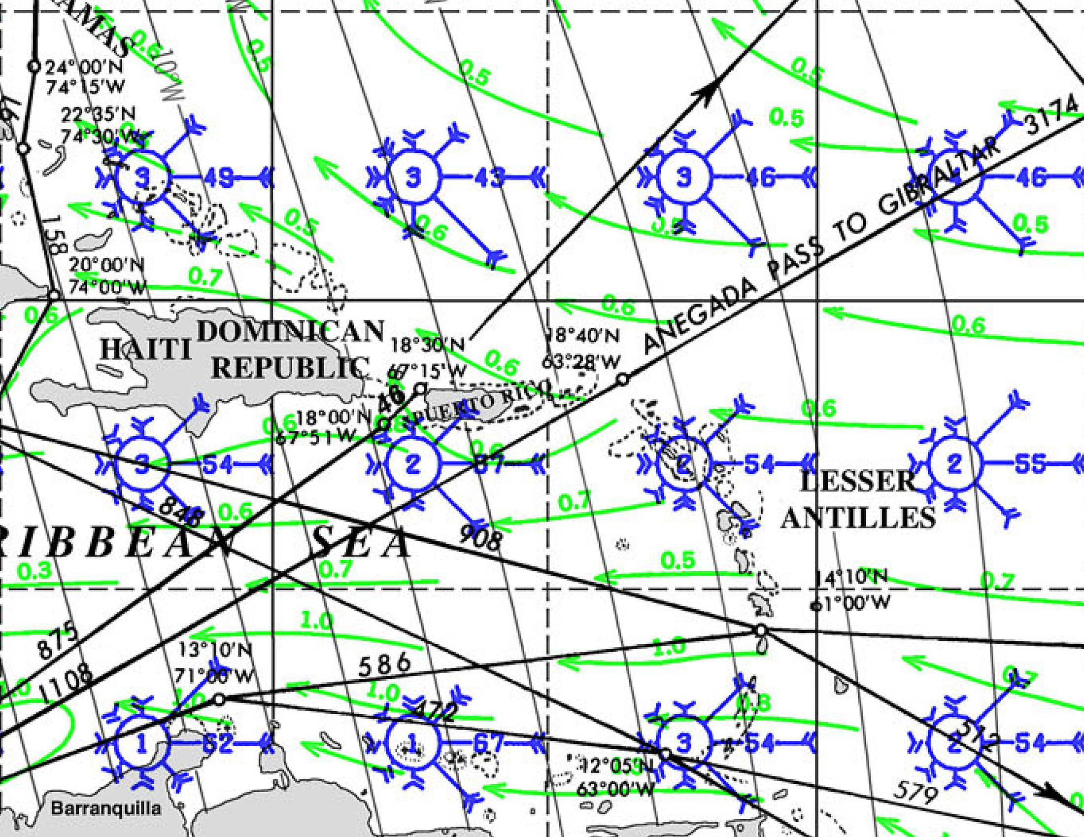
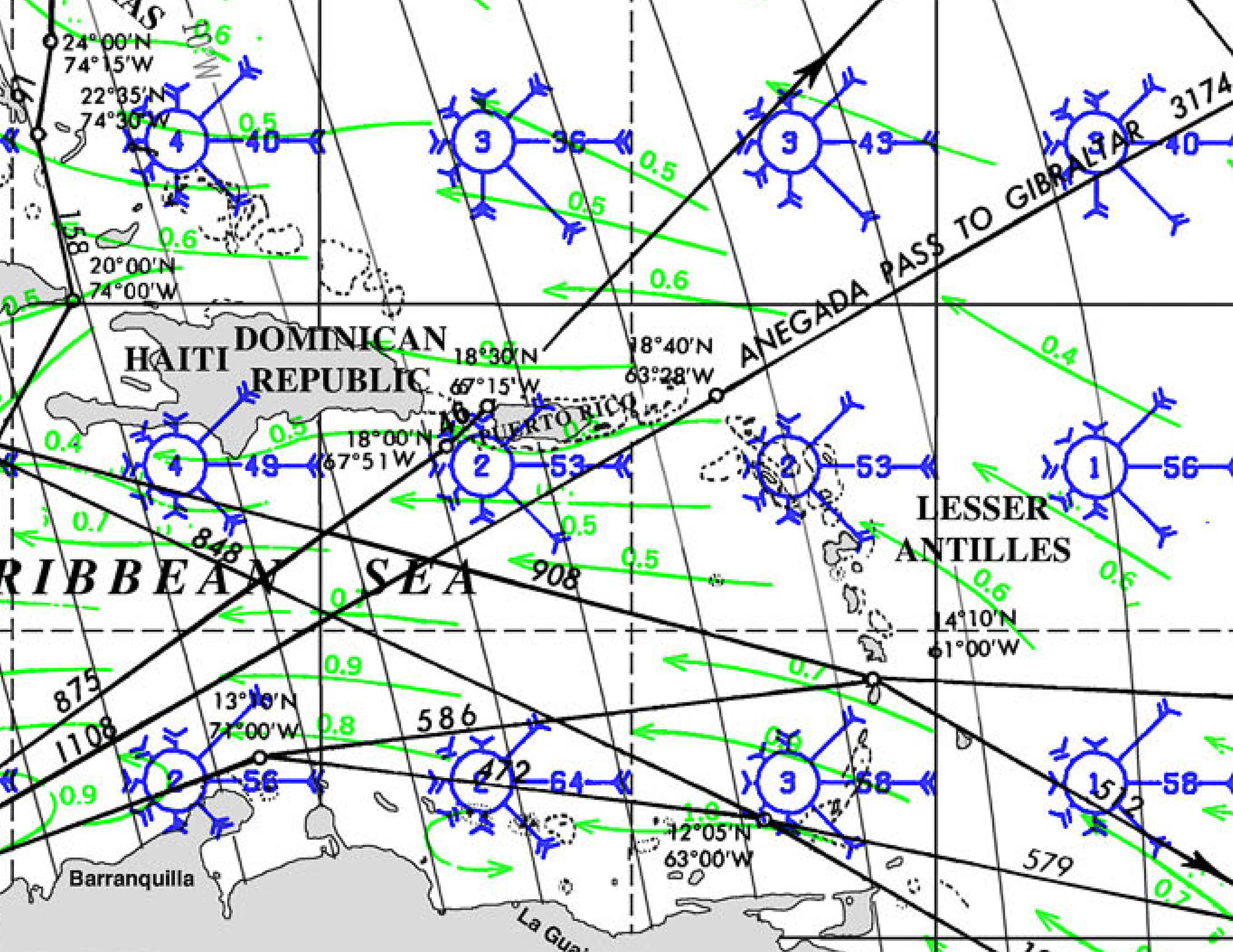
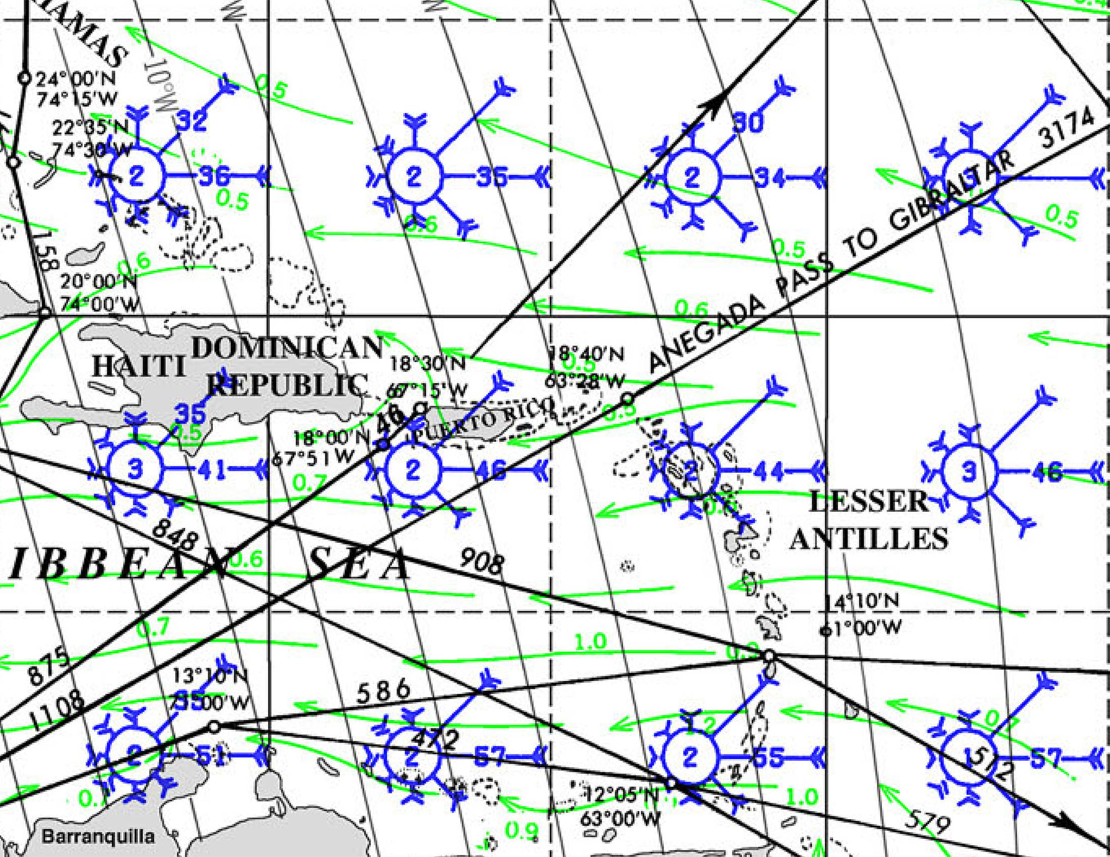
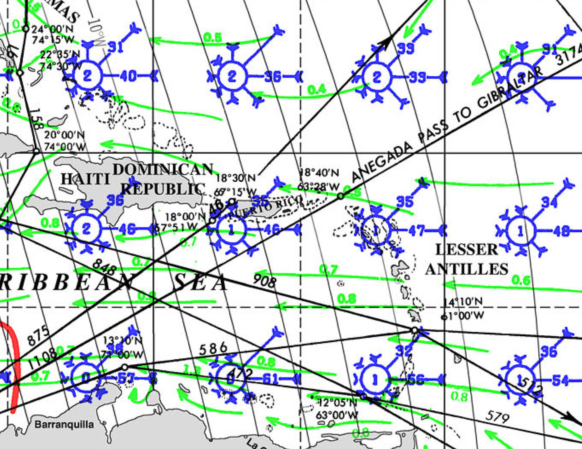
SAINT LUCIA PILOT CHARTS provide historic points and aggregated information of wind flows, air and ocean temperatures, wave heights, rain, barometric weight, and climate conditions at various seasons. This data was acquired from oceanographic and meteorologic perceptions over hundreds of years starting in the late eighteenth century. These diagrams are planned to help mariners choose routes around and approaching Cuba with respect to the normal climate and sea conditions using prevailing seasonal wind information.
PORTS OF ENTRY
Saint Lucia offers several official ports of entry for yachts, each equipped with customs and immigration facilities to ensure a smooth clearance process. Here are the primary ports of entry:
1. Rodney Bay (IGY Rodney Bay Marina)
* Located in the northwest, this is Saint Lucia’s principal port of entry and a major hub for yachting activities.
2. Marigot Bay (Marigot Bay Yacht Haven)
* Situated on the western coast, Marigot Bay is a scenic and sheltered harbor.
* The marina is an international port of entry, housing customs and immigration offices.
3. Soufrière
* Located near the iconic Pitons in the southwest, Soufrière serves as an official port of entry.
* The area offers mooring options and is close to natural attractions like botanical gardens and waterfalls, making it a popular stop for yachts.
4. Vieux Fort
* At the southern tip of the island, Vieux Fort is an official port of entry with a larger docking area suitable for large boats.
* The town provides modern amenities, including supermarkets, shopping malls, and restaurants, and is in proximity to white sandy beaches ideal for windsurfing enthusiasts.
5. Castries Harbour
* Located in the capital city, Castries Harbour is an official port of entry with customs officials on-site.
* Yachts entering the harbor are required to proceed directly to the customs dock; failure to do so may result in fines.
* While it has facilities for yachts, many prefer clearing in at Rodney Bay or Marigot Bay due to more streamlined processes
Each of these ports provides essential services for yachts, including customs and immigration clearance. It’s advisable to check the specific facilities and services available at each port before arrival to ensure they meet your vessel’s requirements.
DOCUMENTS
🇱🇨 Yacht Clearance Documents for Saint Lucia
📄 For the Vessel
-
Vessel Registration Document
-
Proof of ownership and registration (flag state certificate).
-
-
Crew & Passenger List
-
A typed or legible list showing full names, nationalities, passport numbers, and roles (crew/passenger) of everyone aboard.
-
-
Customs Declaration Form
-
Declares goods, equipment, and any dutiable items aboard.
-
-
Clearance from Last Port
-
Official clearance papers (zarpe) from the last country or port visited.
-
-
Maritime Declaration of Health
-
Required especially if there have been any illnesses onboard during transit.
-
📄 For Each Person Onboard
-
Valid Passport
-
Must be valid for at least 6 months beyond the date of entry.
-
-
Saint Lucia Immigration Card (E/D Card)
-
Completed on arrival; often available at the marina or provided by Customs/Immigration.
-
-
Visa (if applicable)
-
Nationals from some countries require a visa in advance. Most EU, UK, US, and Commonwealth country citizens do not require one for short stays.
-
🛂 Arrival Procedures
-
Proceed directly to a designated port of entry (Rodney Bay, Marigot Bay, Soufrière, Vieux Fort, or Castries).
-
Do not disembark or allow anyone ashore until the vessel has cleared Customs and Immigration.
-
Customs and Immigration officers will usually visit the vessel at the marina or dock; in some ports, the captain may need to visit the offices ashore.
📌 Notes
-
Overtime charges may apply if clearing in after hours, weekends, or holidays.
-
Pets must be declared in advance and meet Saint Lucia’s import regulations.
-
Firearms must be declared and surrendered to customs upon arrival. Failure to do so can result in serious penalties.
MUST SEE
🏔️ 1. The Pitons (Gros & Petit Piton) – View or Hike
Even if you don’t climb them, Gros Piton is hikeable (Petit is not). The guided hike is a physical challenge but rewards with panoramic island views. UNESCO World Heritage site.
🌋 2. Sulphur Springs & Drive-In Volcano (Soufrière)
Billed as the “world’s only drive-in volcano.” Boiling mud pools, sulfur steam vents, and hot mineral baths make it a surreal, must-do volcanic experience.
🌿 3. Tet Paul Nature Trail
Near the Pitons, this short, guided hike offers one of the best views of both Pitons without the physical exertion. Great for photography and cultural insights.
🧘 4. Diamond Falls Botanical Gardens & Mineral Baths
A beautifully landscaped garden with a waterfall colored by volcanic minerals. The original baths were built in 1784 for French troops—now open to the public.
🏞️ 5. Edmund Forest Reserve Hike
Off-the-beaten-path rainforest hike inland from Soufrière. Dense jungle, rare birds (like the Saint Lucian parrot), and waterfalls—guided hikes highly recommended.
🏰 6. Morne Fortune & Old British Fort (Castries)
Panoramic views of Castries and a slice of colonial military history. Includes Government House and ruins of old British garrisons.
🥘 7. Castries Market & Vendor’s Arcade
Bustling local market for spices, fruits, handicrafts, and hot street food. Great spot to feel the urban pulse and meet Saint Lucians.
🎭 8. Fond Latisab Creole Park (Babonneau)
A living cultural museum. Participate in cassava bread making, see traditional dances, and hear Saint Lucian stories and songs in Kweyol.
🌄 9. Millet Bird Sanctuary & Community Trail
A quieter, eco-tourism spot inland with trails through forested hills and excellent birdwatching—home to the rare Saint Lucia parrot (Amazona versicolor).
🛕 10. Balenbouche Estate
A colonial-era sugar plantation turned heritage site. Offers tours, short hikes, yoga retreats, and a glimpse into Saint Lucia’s complex colonial past.
REPAIRS AND SERVICE PROVIDERS
🔧🛠️ 1. IGY Rodney Bay Marina (Gros Islet – Northwest)
This is the primary and most comprehensive yacht service hub in Saint Lucia.
* Haul-Out Facility:
* 75-ton travel lift (up to 31.5 ft beam)
* Hardstand and long-term dry storage
* Pressure washing, blocking, bottom painting, and more
* On-Site Services:
* Mechanical and electrical repair
* Fiberglass and hull work
* Marine electronics
* Engine servicing (authorized Yanmar dealer available)
* Sail and canvas repair (e.g., Saint Lucia Sails)
* Stainless steel & aluminum fabrication
* Propeller and shaft work
* Chandlery (Island Water World)
* Contact:
* www.igymarinas.com
* VHF Channel 16 / 12
* Customs & Immigration on-site
🧰 2. Marigot Bay Marina (Marigot – West Coast)
Luxury-focused marina with limited repair capabilities. Best for provisioning and light repairs.
* Haul-Out: ❌ No haul-out facility
* Services:
* Minor electrical/mechanical repairs
* Yacht cleaning, dive services
* Concierge services for sourcing contractors
* Fuel dock and customs available
* Contact:
* marigotbayyachthaven.com
🔧 3. Saint Lucia Marine Services (Rodney Bay Boatyard)
Located within IGY Rodney Bay Marina, this is the go-to yard for serious repairs and overhauls.
* Services:
* Hull painting (including antifouling)
* Rigging inspections and replacements
* Engine repower and servicing
* Gelcoat and fiberglass repair
* Marine carpentry
* Hurricane tie-downs available
* Onsite Marine Trades:
* Electronics specialists
* Refrigeration and A/C techs
* Metal fabricators and welders
* Surveyors
⚓ Other Notes
* Dry season (December–May) is the busiest time; haul-out appointments should be booked well in advance.
* Hurricane season (June–November): Rodney Bay offers some hurricane-prep services and secure tie-down areas.

EMERGENCIES AND SAR INFO

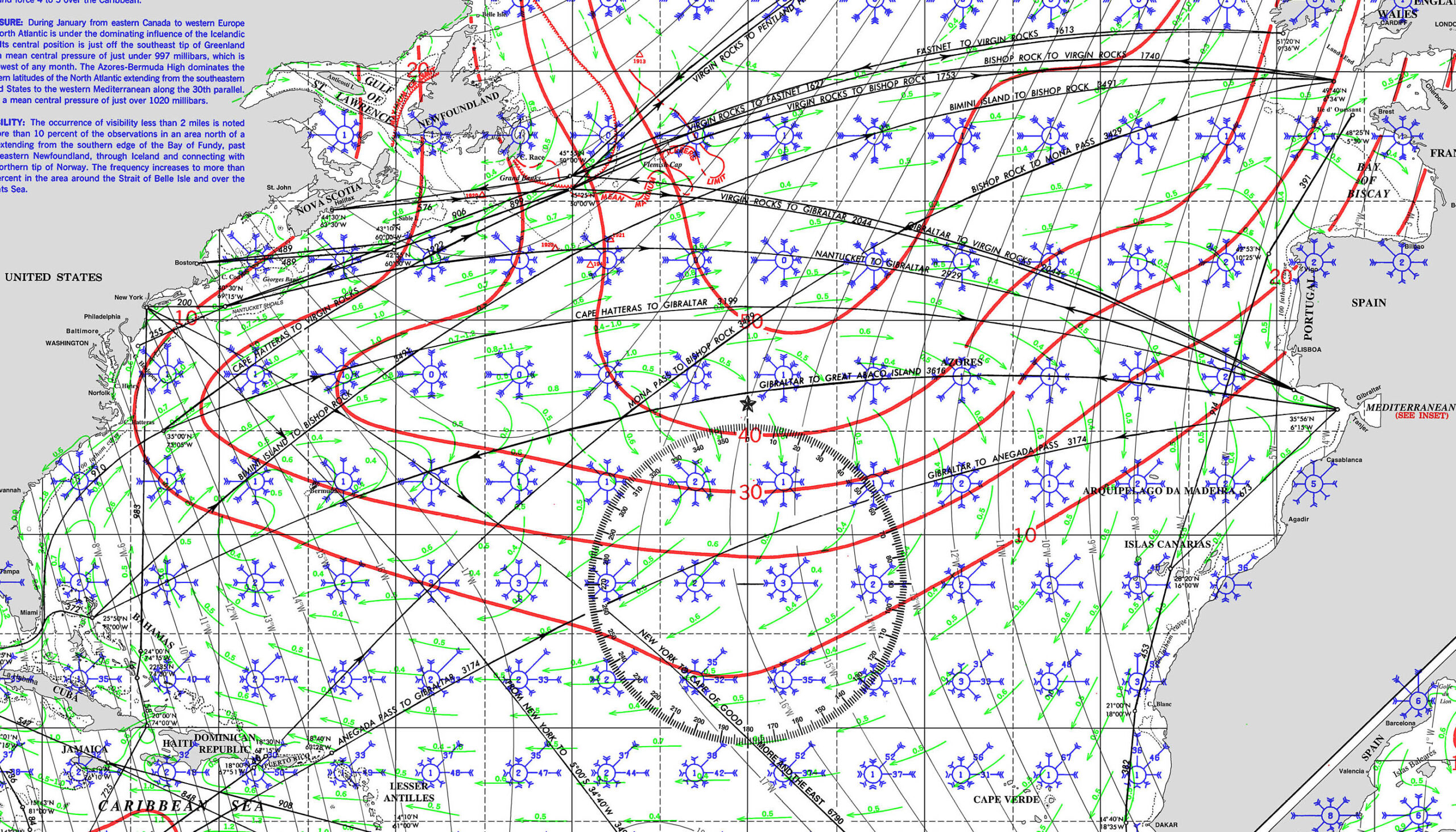
ATLANTIC CROSSING WEST TO EAST : Bahamas → Bermuda → Azores → Portugal
Bahamas – Bermuda – Azores
Crossing from The Bahamas to Bermuda to the Azores in May is a classic transatlantic route favored by many bluewater cruisers heading to Europe. Here’s a breakdown of the route, conditions, and considerations for each leg:
🟦 1. Bahamas to Bermuda
Distance: ~780 NM from Eleuthera/Abaco to St. George’s
Typical Duration: 5–7 days
Best Time: Late April to mid-May
⛵ Conditions:
-
Prevailing Winds: East to southeast trades, 10–20 knots.
-
Weather systems: Watch for cold fronts exiting the U.S. East Coast. These can bring squalls and NW winds.
-
Currents: You’ll skirt the Gulf Stream, but don’t aim directly through its strongest parts; stay on its eastern edge.
-
Routing : Wait for a weather window with SE-SW winds ahead of a front, then ride the shift N-NE to Bermuda
-
Average wave height: 1–2.5 meters (3–8 ft)
-
Sea pattern: Generally moderate trade swell mixed with wind-driven chop.
-
Gulf Stream Influence: If you get close to the stream, expect steep, confused seas especially if wind opposes current (e.g., NE wind against northbound current = square waves and breaking crests).
-
Best Strategy: Route east of the Stream and time departure before or after a frontal passage for cleaner following or beam seas
🔄 1. Bahamas to Bermuda – Currents
✅ Main Concern: The Gulf Stream
-
Flow: ~2–4 knots northward
-
Location: From Florida Straits eastward to ~73°W
-
Effect: If you cross it perpendicularly, you’ll get through quickly. If you sail along it, it can speed you up—or severely slow and toss you if wind opposes it.
-
Best Practice:
-
Route east of the main core of the Stream when possible.
-
Watch for eddies—they spin off and may carry NE or SW flow.
-
Get real-time data via NOAA Gulf Stream Analysis or PassageWeather.
-
🌀 Eddies (spin-offs from the Gulf Stream)
-
May assist or hinder depending on position.
-
Can be up to 1 knot and last days/weeks.
SWELL AND WAVES
Tides and Currents
The tidal currents from the Bahamas to Bermuda
🟦 2. Bermuda to Azores
Distance: ~1,900 NM
Typical Duration: 12–18 days
Best Time: Mid-May to early June
⛵ Conditions:
-
Winds: Variable — expect anything from SE trades to light airs, with possible gales from mid-latitude depressions.
-
High Pressure: The Azores High often expands NE this time of year, creating large calm zones. Engines may be needed.
-
Lows: North Atlantic depressions track above 35°N, but can dip south. Routing slightly south (~32°–35°N) may avoid worst of these.
-
Routing : Some cruisers head ENE at first, then curve east or southeast depending on GRIBs.
-
Average wave height: 1.5–3.5 meters (5–12 ft), but can spike to 4–5 m (12–16 ft) in passing lows.
-
Wave period: Often 8–12 seconds, but can shorten drastically in rougher conditions.
-
Cross seas: Common — leftover swell from previous systems (NW to W) combined with current wind-driven sea (E to SE) can result in confused, lumpy motion.
-
Calm Zones: If trapped in the middle of the Azores High, expect long rolling swells and glassy calm with some leftover chop.
-
Worst case: A passing low can bring sustained 25–35 knots and seas building to 4+ meters if you’re too far north.
🔄 2. Bermuda to Azores – Currents
🌊 North Atlantic Subtropical Gyre
-
Dominated by the Azores Current and North Atlantic Drift
-
Average flow: 0.5 knots or less, generally eastward or southeastward
-
More benign than Gulf Stream — but slow currents can help or hinder over long durations
✅ General Strategy
-
Below 35°N: Currents tend to be weak and variable; routing focuses more on avoiding lows than riding currents.
-
Above 35–37°N: You may tap into light westerly-setting flows, but you also risk getting closer to stronger systems and rougher seas.
Preparation & Planning
-
Fuel: Ensure ample diesel for motorsailing (especially Bermuda–Azores).
-
Weather Tools: Use PredictWind, Saildocs, NOAA OPC, and get forecasts via Starlink – Iridium GO, Starlink, or SSB.
-
Safety: This is an offshore ocean passage — have liferaft, EPIRB, AIS, storm sails, and proper watch routines.
Notes from Cruisers
-
May offers one of the better weather windows before hurricane season and before the North Atlantic becomes too unsettled.
-
Boats often gather in St. George’s, Bermuda for final prep and wait for a good window.
-
The Azores (usually Faial/Horta) are a welcoming and essential landfall, with fuel, repairs, and a strong cruiser community.
Tides and Currents
The tidal currents from the Bahamas to Bermuda
PILOT CHARTS


AZORES – PORTUGAL MAINLAND
🧭 OVERVIEW
-
Route: Azores (e.g., Horta, Faial) to Lisbon (mainland Portugal)
-
Distance: ~800 to 1,000 nautical miles (depending on your port of departure and arrival)
-
Duration: 6–10 days (average for cruising yachts, depending on wind and routing)
-
Season: Best time is May to September; outside of this window, expect more lows and heavier Atlantic weather
⛵ ROUTE OPTIONS
1. Direct Route
-
Faial (Azores) ➝ Lisbon
-
Rhumb line distance ~870 NM
-
Oceanic sailing until you approach the continental shelf near Cabo da Roca
2. Coastal Approach via Porto
-
Faial ➝ Porto ➝ Lisbon
-
Adds safety and flexibility with a stop on the mainland’s northwest coast
-
Recommended if you’re waiting for weather or need repairs/provisioning
🌬️ WIND & WEATHER
-
Prevailing Winds (May–September):
-
Azores High dominates: NE trades or light variable winds
-
Often beam to broad reach on port tack if routing N-NE out of Horta first
-
-
Fall/Winter:
-
Lows track across the North Atlantic; expect more frequent SW–W winds, squalls, and rougher seas
-
⚓ LANDFALL & PORTS
Suggested Landfall:
-
Cascais: Good first stop, protected marina at the mouth of the Tagus River, easier than entering Lisbon proper if arriving at night or tired
-
Lisbon (Doca de Alcântara, Marina Parque das Nações): Further up the Tagus, good facilities and access to the city
Optional Stops:
-
Ponta Delgada (São Miguel): Staging point if leaving from eastern Azores
-
Porto (Leixões Marina): Safe harbor before rounding Cabo da Roca
-
Nazaré or Peniche: More protected ports along the coast if a stop is needed due to weather
⚠️ NOTES & CONSIDERATIONS
-
Watch for fog near the Azores and Portuguese coast, especially in early summer
-
Shipping traffic increases significantly near the Iberian shelf and as you approach the entrance to Lisbon
-
Keep an eye out for Portuguese man o’ war and floating debris in calm zones
-
VHF and AIS essential for this route
WINDS
Tides and Currents
SWELL AND WAVES
[/mepr-show]