
 Cape Verde, an archipelago of 10 volcanic islands in the central Atlantic Ocean, is a must-visit destination for cruisers seeking a mix of adventure, cultural richness, and stunning natural beauty. Located off the coast of West Africa, it offers a unique blend of African, Portuguese, and Brazilian influences, making it a fascinating stopover for yachts crossing the Atlantic.
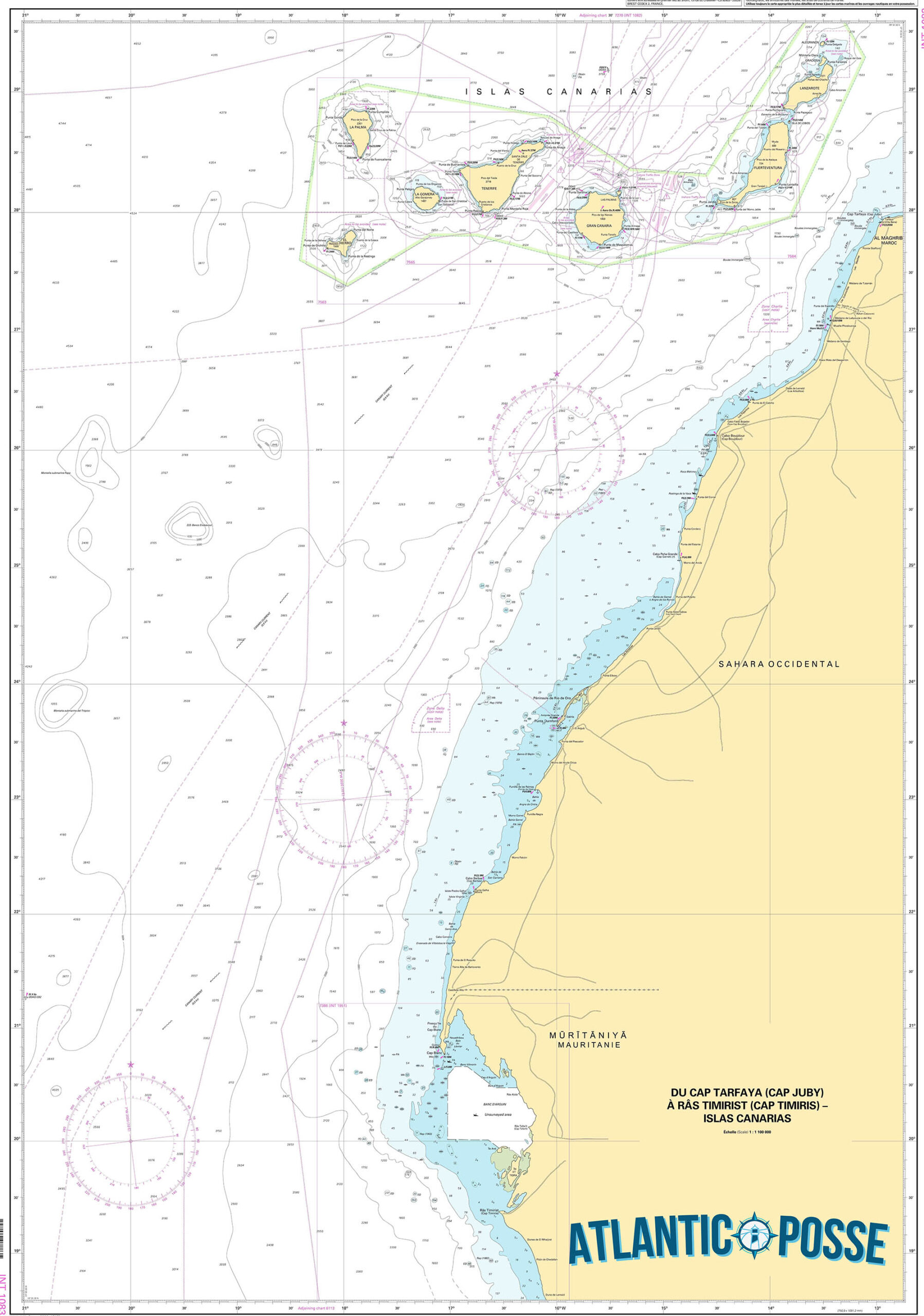
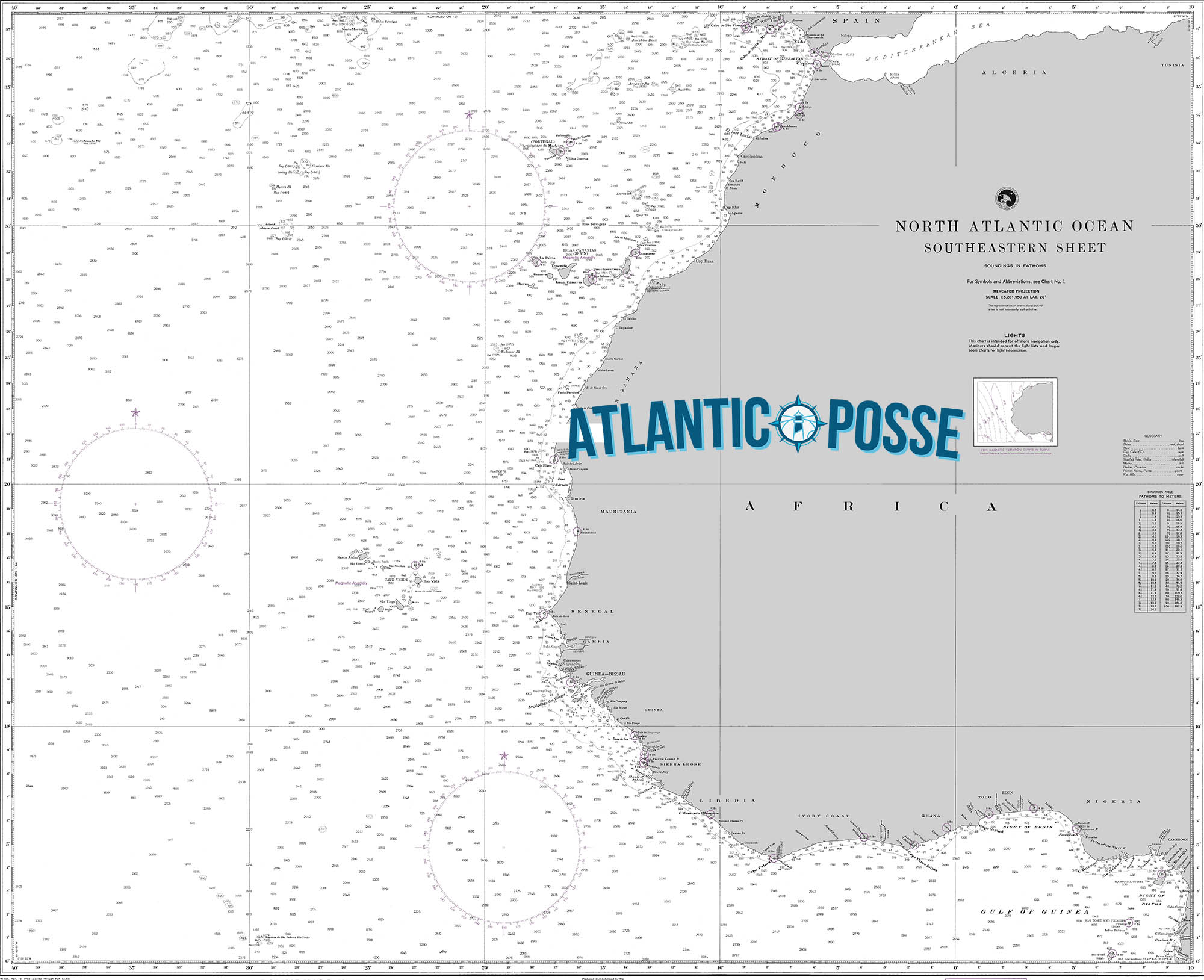
Navigational Insights: Approaching Cape Verde from the north or east is relatively straightforward, with the islands offering good visibility. However, the Harmattan winds, blowing from the Sahara, can occasionally reduce visibility and cause dust haze, so it’s wise to stay vigilant. The seas around the islands can be choppy, especially during the winter months when the northeast trade winds are strong. Careful navigation is required around the islands’ numerous reefs and rocky outcrops, especially when approaching ports.
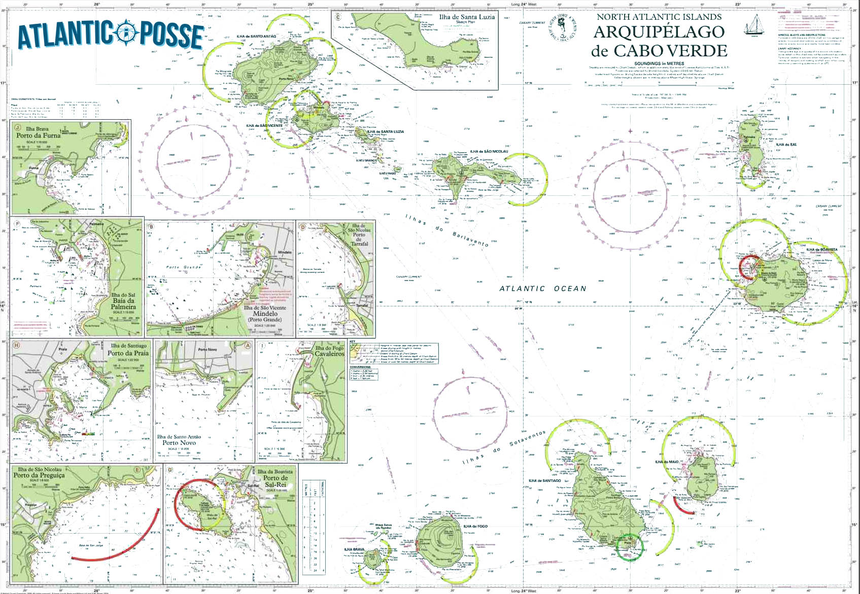
Ports and Anchorages: Cape Verde has several ports and anchorages suitable for yachts. Mindelo on São Vicente is the main port of entry and offers the best facilities, including fuel, water, provisions, and repairs. The marina is well-protected, and the local maritime authorities are generally helpful. Tarrafal on Santiago Island and Sal Rei on Boa Vista are also popular stops, providing safe anchorages and opportunities to explore the islands.
Weather and Timing: The best time to visit Cape Verde is between November and April when the trade winds are consistent, making for smooth sailing conditions. The climate is arid, with temperatures ranging from 22°C to 30°C. The rainy season, which runs from August to October, can bring sudden downpours and rougher seas, but these are generally short-lived.
Cultural and Shore Experiences: Cape Verde’s culture is a vibrant mix of African and Portuguese traditions. The islands are known for their morna music, a melancholic genre that reflects the nation’s history and soul. Cruisers can enjoy the lively markets, local cuisine, and the warm hospitality of the Cape Verdean people. Exploring the islands reveals dramatic landscapes, from the barren, lunar-like terrain of Sal to the lush green valleys of Santo Antão.
Challenges: While Cape Verde is a welcoming destination, cruisers should be aware of potential challenges. Provisioning outside of Mindelo can be limited, so it’s advisable to stock up on essentials. Water can also be scarce, particularly on the drier islands. Security is generally good, but it’s wise to take precautions, especially in more remote anchorages.
Conclusion: Cape Verde is a rewarding destination for cruisers, offering a unique blend of cultures, breathtaking landscapes, and reliable sailing conditions. Whether using it as a stopover on an Atlantic crossing or as a destination in its own right, Cape Verde provides a rich cruising experience that stays with you long after you’ve sailed away.
MARINAS
1. Mindelo Marina, São Vicente
- Location: 16°53.457’N 24°59.210’W
- Description: Mindelo Marina is the largest and most popular marina in Cape Verde, located in the bustling port city of Mindelo on São Vicente Island. The marina offers 120 berths, modern facilities, and is well-protected from prevailing winds. It’s a primary stop for yachts crossing the Atlantic, with services including fuel, water, electricity, Wi-Fi, laundry, and a well-stocked chandlery. The nearby town is vibrant, offering plenty of dining, entertainment, and provisioning options, along with a rich cultural experience.
- Contact: +238 232 10 70 / info@marinamindelo.cv
2. Porto Grande Bay, São Vicente
- Location: 16°53.604’N 24°59.197’W
- Description: While not a dedicated marina, Porto Grande Bay is a natural harbor adjacent to Mindelo Marina, offering excellent anchorage. The bay is deep and spacious, with good holding ground, making it a popular choice for those preferring to anchor. The bay is also home to the Mindelo Yacht Club, which provides some facilities to visiting yachts, including showers and a bar. This location is convenient for accessing Mindelo’s amenities without the need for a formal berth.
- Contact: +238 232 11 21 / yachtclubemindelo@gmail.com
3. Sal Rei Anchorage, Boa Vista
- Location: 16°10.423’N 22°54.964’W
- Description: Sal Rei is the main anchorage on Boa Vista Island, located near the town of the same name. The anchorage is generally calm, protected by surrounding reefs and islets, though care must be taken when navigating through the entrance. The town is smaller and more laid-back compared to Mindelo, but offers basic provisions, a few local restaurants, and the opportunity to explore Boa Vista’s stunning beaches and dunes. There is no marina here, so all services must be managed independently.
- Contact: No marina facilities, local authorities available via VHF Channel 16.
4. Palmeira Harbor, Sal
- Location: 16°45.231’N 22°59.732’W
- Description: Palmeira Harbor on the island of Sal is a well-sheltered anchorage primarily used by fishing boats and visiting yachts. The harbor has no marina, but it offers a secure spot to anchor with easy access to the town of Palmeira, where basic services and provisions can be found. Sal Island is known for its water sports, particularly windsurfing and kiteboarding, and cruisers can explore the island’s stark, beautiful landscape. Fresh water is available at the harbor, but facilities are limited.
- Contact: No formal marina, VHF Channel 16 for local authorities.
5. Porto Tarrafal, Santiago
- Location: 15°16.986’N 23°45.292’W
- Description: Porto Tarrafal is located on the northern coast of Santiago Island and is a well-known anchorage spot for cruisers. The bay offers good protection from the northeast trade winds, with a sandy bottom providing secure anchoring. The small town of Tarrafal is charming, with local markets, eateries, and a relaxed atmosphere. The beach is one of the best in Cape Verde, with clear waters ideal for swimming. There are no marina facilities, so yachts must be self-sufficient.
- Contact: No formal marina, VHF Channel 16 for local authorities.
6. Porto da Praia, Santiago
- Location: 14°54.423’N 23°30.156’W
- Description: Porto da Praia is the main commercial port on Santiago Island, situated in the capital city of Praia. While primarily a commercial and fishing port, there is a designated anchorage area for yachts. The port is busy, so yachts must be vigilant of ship traffic. Praia offers full city amenities, including provisioning, restaurants, and cultural sites. Security can be a concern, so precautions are advised. There are no marina facilities specifically for yachts, but some basic services like fuel and water are available.
- Contact: +238 261 47 12 / porto.praia@enapor.cv
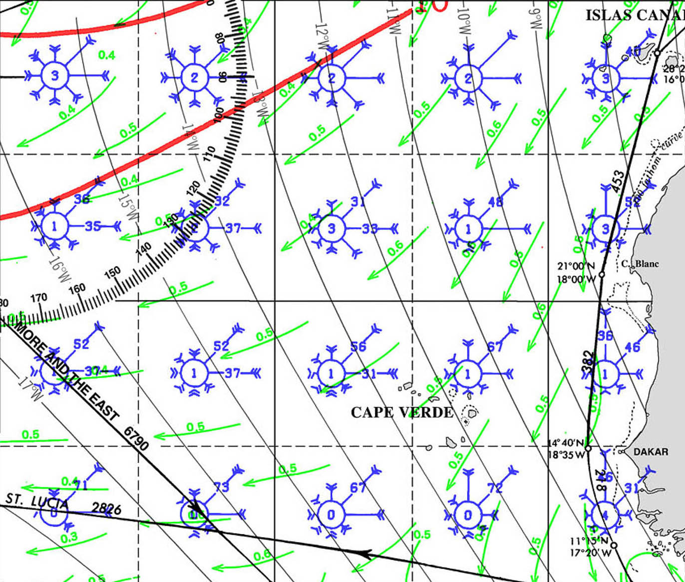
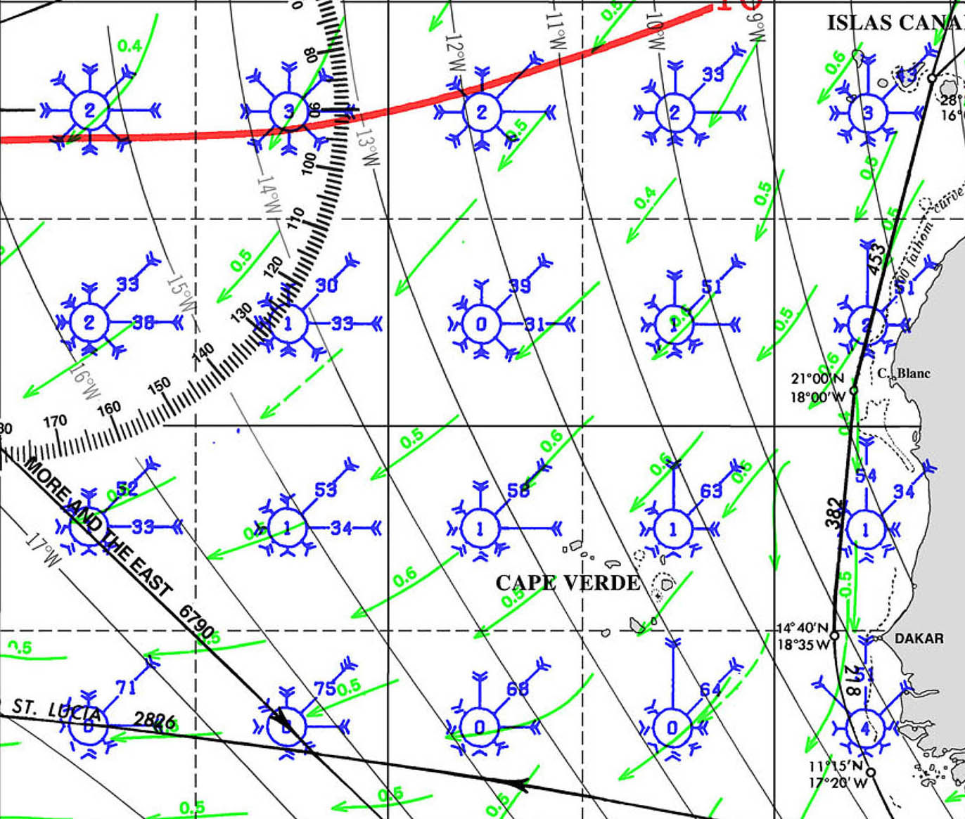
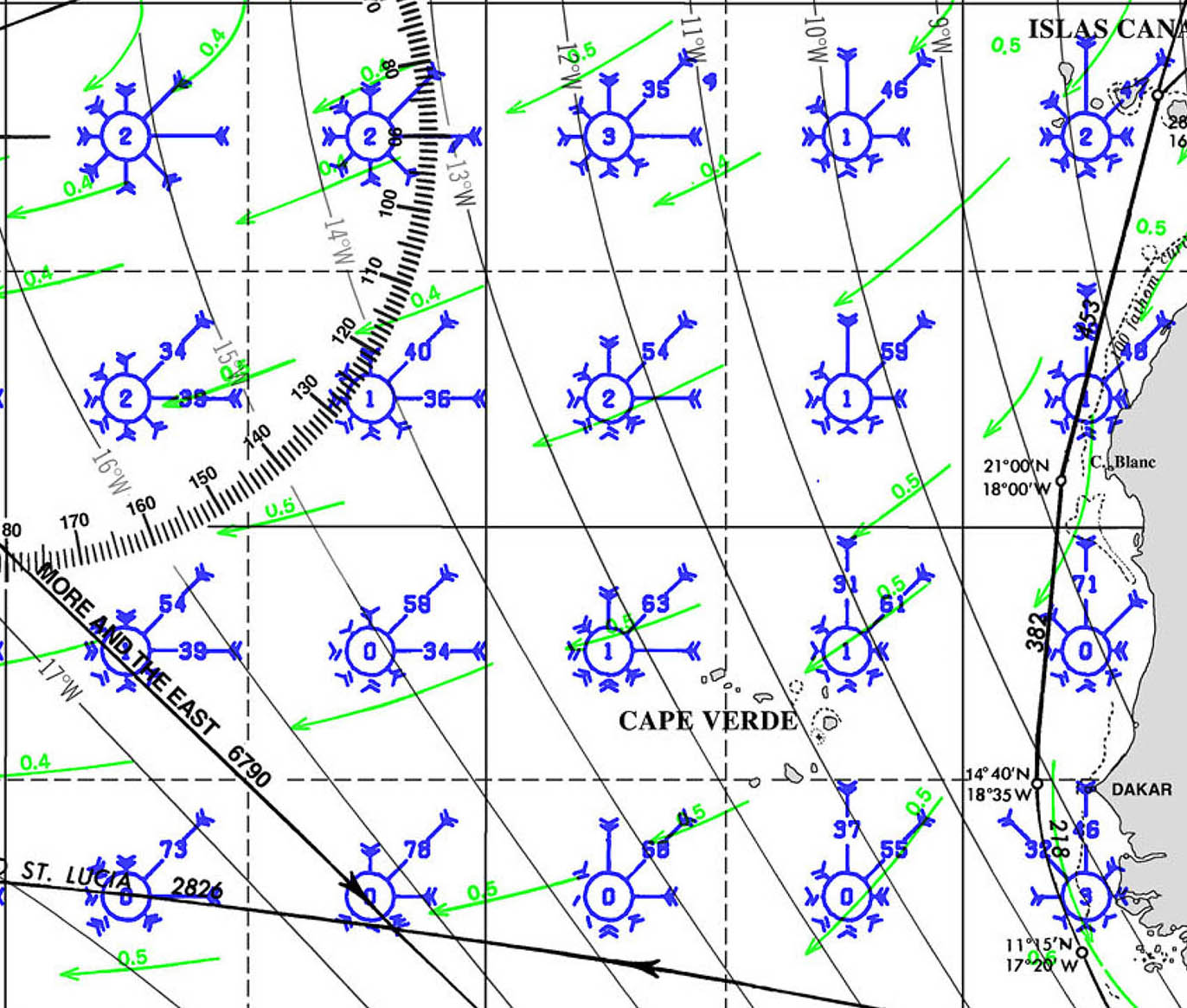
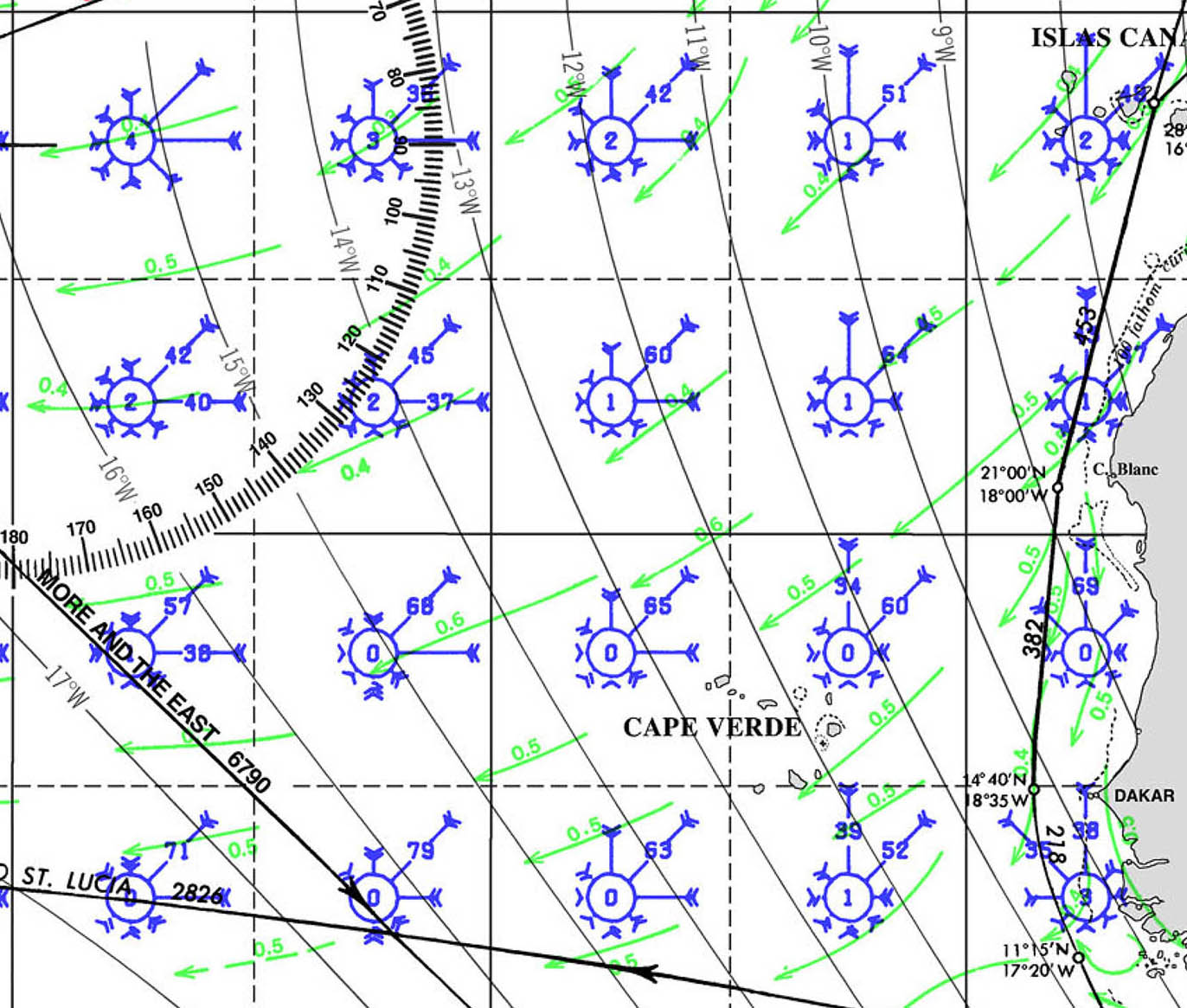
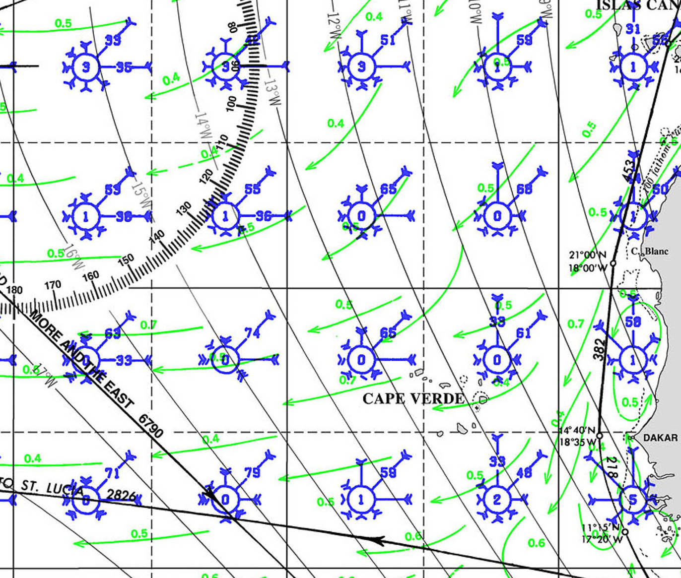
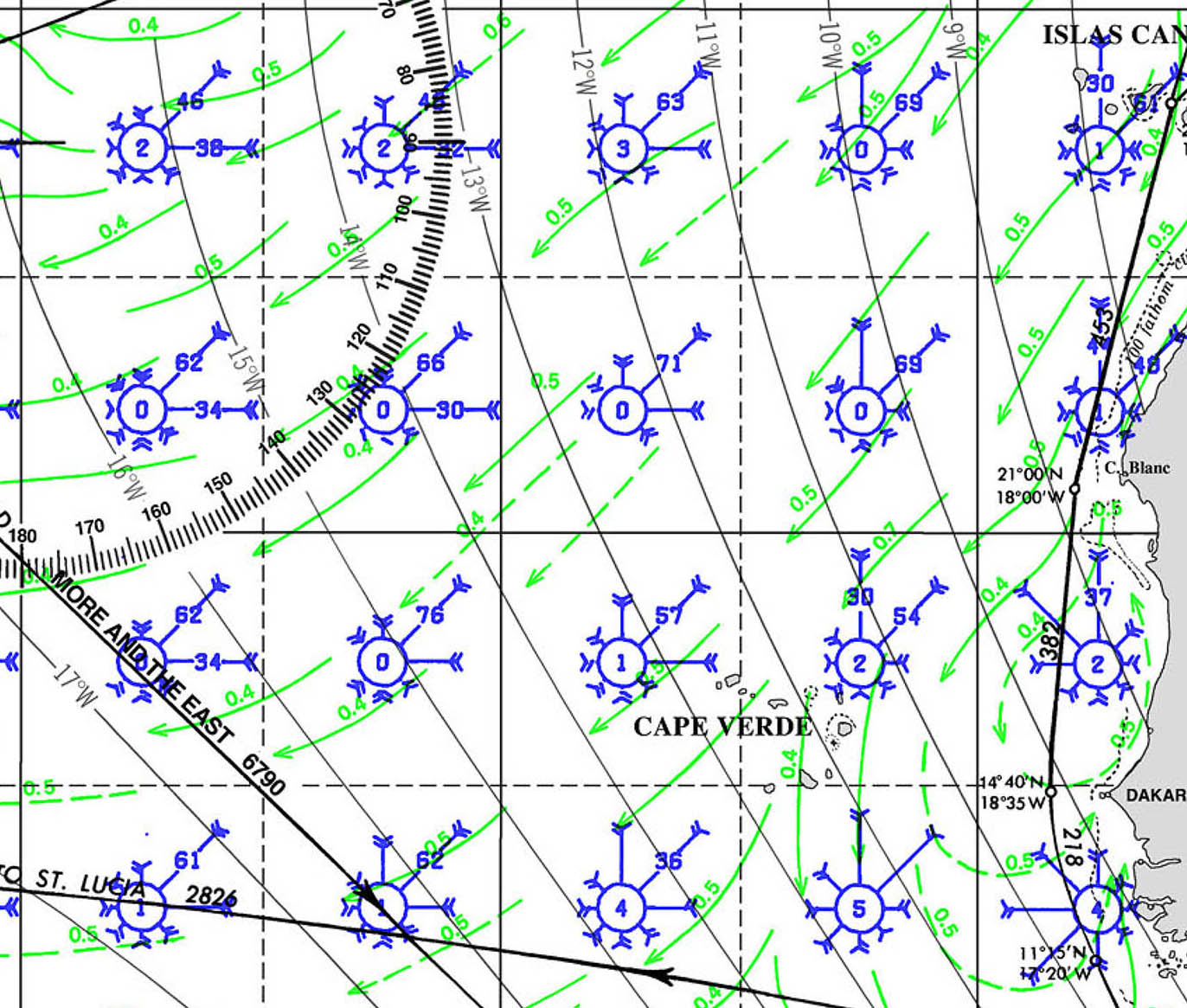
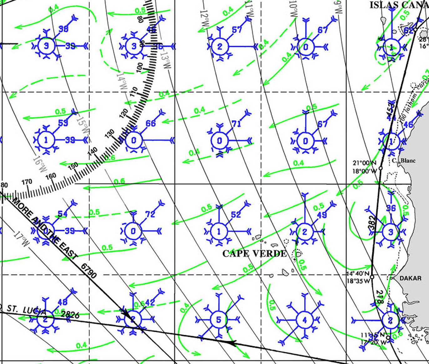
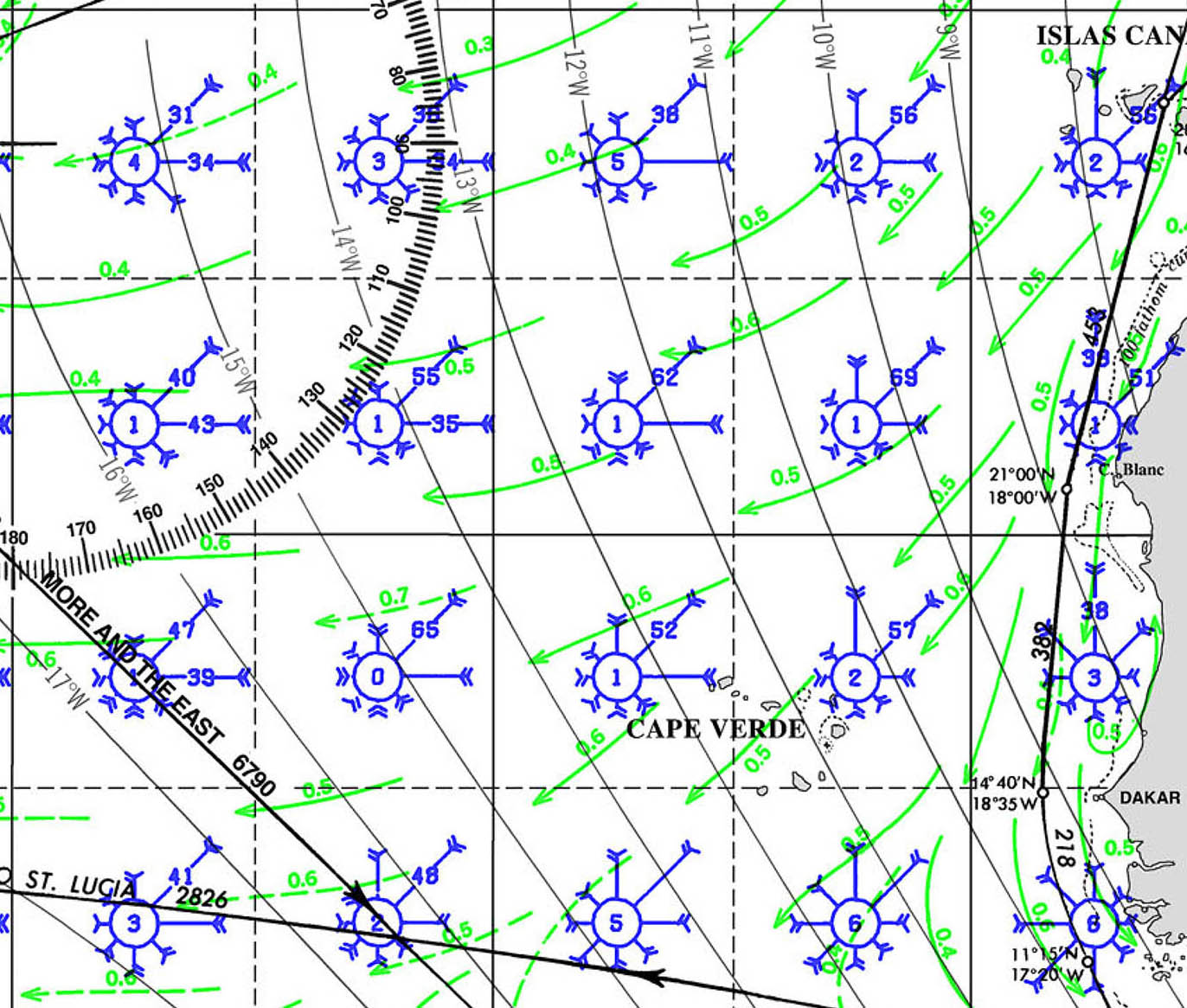
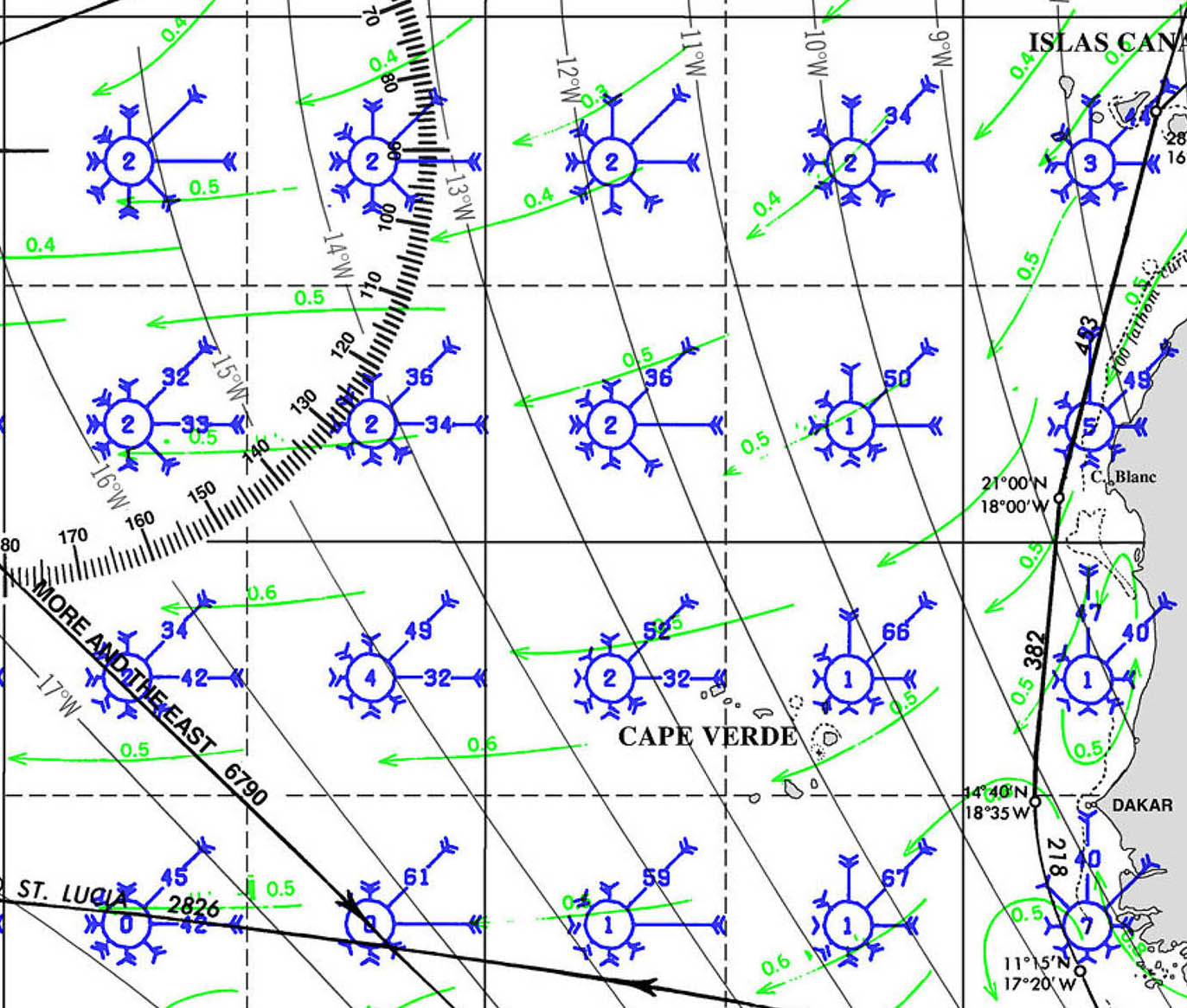
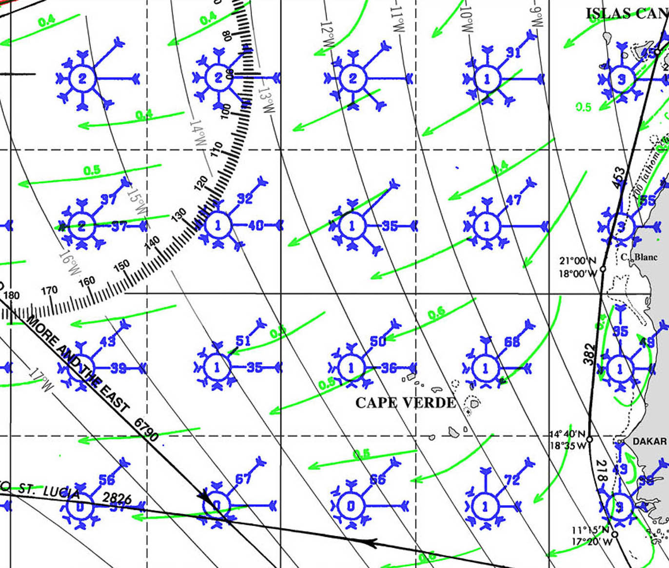
WEATHER CAPE VERDE


PORTS OF ENTRY CAPE VERDE
Ports of Entry: Mindelo|Sao Vicente, Palmeira|Sal, Praia|Santiago
1. Mindelo, São Vicente
- Location: 16°53.457’N 24°59.210’W
- Description: Mindelo is the most popular port of entry for yachts arriving in Cape Verde. Located on the island of São Vicente, it has a well-equipped marina and is a bustling hub for maritime activities. Customs and immigration are located near the marina, and the process is generally straightforward. Mindelo is known for its vibrant cultural scene and serves as a convenient base for exploring the surrounding islands.
- Contact: +238 232 10 70 / info@marinamindelo.cv
2. Praia, Santiago
- Location: 14°54.423’N 23°30.156’W
- Description: Praia, the capital of Cape Verde, is another important port of entry, located on the island of Santiago. The port is primarily commercial, but there are facilities for yachts to clear customs and immigration. The port is busy, so yacht crews should be prepared for possible delays, especially during peak shipping times. Praia offers full city amenities, including embassies, making it a practical location for handling formalities.
- Contact: +238 261 47 12 / porto.praia@enapor.cv
3. Palmeira, Sal
- Location: 16°45.231’N 22°59.732’W
- Description: Palmeira, located on Sal Island, is a popular port of entry for yachts, especially those arriving from the north. The harbor is sheltered, and customs and immigration officers are usually available to handle formalities. Palmeira is a small, laid-back town with basic amenities. Sal is known for its beautiful beaches and water sports, making it a pleasant first stop in Cape Verde.
- Contact: Local authorities available via VHF Channel 16
4. Tarrafal, Santiago
- Location: 15°16.986’N 23°45.292’W
- Description: Tarrafal, located on the northern coast of Santiago Island, is a smaller, more relaxed port of entry. While it doesn’t have the extensive facilities of Mindelo or Praia, it offers a quieter and more scenic location to handle entry formalities. Customs and immigration services are available, although the process may be slower due to the smaller scale of operations.
- Contact: Local authorities available via VHF Channel 16
5. Sal Rei, Boa Vista
- Location: 16°10.423’N 22°54.964’W
- Description: Sal Rei is the main town on Boa Vista Island and serves as a port of entry for yachts. The anchorage is protected, but there are no marina facilities, so yachts must anchor offshore and dinghy in for formalities. Boa Vista is less developed than other islands, offering a more remote and tranquil experience. Customs and immigration services are available in the town.
- Contact: Local authorities available via VHF Channel 16
Clearing Procedures:
- Documents Required: Passports, crew lists, vessel registration, and clearance from the previous port.
- Process: Upon arrival, proceed to the port’s customs and immigration office to complete the necessary paperwork. Be prepared to present your ship’s papers, crew list, and passports. The process is generally straightforward but can vary slightly depending on the port and local conditions.
- Health and Safety: As of the latest updates, no specific health checks are required beyond standard procedures, but it is advisable to check for any changes in requirements before arrival, especially due to ongoing global health concerns.
These ports of entry offer varied experiences for arriving yachts, from the bustling atmosphere of Mindelo to the more serene setting of Tarrafal. Each port provides an opportunity to explore the rich culture and natural beauty of Cape Verde.
MUST SEE
1. Monte Verde, São Vicente
- Location: 16°52.532’N 24°57.898’W
- Description: Monte Verde is the highest point on São Vicente Island, standing at 750 meters above sea level. The mountain offers panoramic views of the entire island, including the city of Mindelo, the surrounding valleys, and the Atlantic Ocean. The hike to the summit is moderately challenging, taking you through unique flora and volcanic landscapes. The views from the top are breathtaking, especially at sunrise or sunset, where the island’s rugged beauty is fully illuminated. On clear days, you can even catch a glimpse of neighboring islands like Santo Antão.
- Best Time to Visit: November to April, during the dry season, when the skies are clear, and the temperatures are comfortable for hiking.
2. Praia de Santa Maria, Sal
- Location: 16°36.494’N 22°54.320’W
- Description: Praia de Santa Maria is one of Cape Verde’s most famous beaches, located on the island of Sal. The beach stretches for 8 kilometers, with golden sands and turquoise waters that are ideal for swimming, sunbathing, and water sports. The beach is dotted with colorful fishing boats, adding to its charm. Santa Maria town is nearby, offering a lively atmosphere with restaurants, bars, and shops. The beach is also a hub for windsurfing, kiteboarding, and diving, attracting water sports enthusiasts from around the world.
- Best Time to Visit: December to June, when the weather is warm and dry, and the winds are favorable for water sports.
3. Cidade Velha, Santiago
- Location: 14°54.144’N 23°36.221’W
- Description: Cidade Velha, located on Santiago Island, is a UNESCO World Heritage site and the oldest European colonial settlement in the tropics. Founded in 1462, it was the first capital of Cape Verde and played a significant role in the Atlantic slave trade. The town is home to several historical landmarks, including the Royal Fortress of São Filipe, the Church of Our Lady of the Rosary, and the Pelourinho (pillory). Walking through the cobbled streets, you can feel the weight of history and the cultural fusion that defines Cape Verde.
- Best Time to Visit: November to May, when the weather is dry and cool, making it ideal for exploring historical sites.
4. Pico do Fogo, Fogo
- Location: 14°57.892’N 24°21.530’W
- Description: Pico do Fogo is an active stratovolcano and the highest peak in Cape Verde, reaching an altitude of 2,829 meters. Located on Fogo Island, the volcano last erupted in 2014, leaving behind a dramatic landscape of black lava fields and ash-covered slopes. The hike to the summit is challenging but rewarding, offering unparalleled views of the island and beyond. The surrounding Cha das Caldeiras is a small village where locals cultivate grapes and coffee in the fertile volcanic soil.
- Best Time to Visit: November to February, during the cooler months, when the weather is most favorable for hiking.
5. Santo Antão, Santo Antão
- Location: 17°06.041’N 25°09.501’W
- Description: Santo Antão is the greenest and most mountainous island in Cape Verde, known for its stunning landscapes and traditional villages. The island is a hiker’s paradise, with trails that wind through lush valleys, terraced fields, and rugged cliffs. The Ribeira Grande valley, the Paul Valley, and the coastal village of Ponta do Sol are some of the highlights. The island’s remote and untouched beauty makes it a perfect destination for those looking to experience the natural side of Cape Verde.
- Best Time to Visit: October to May, during the dry season, when the weather is mild, and the trails are accessible.
6. Salinas de Pedra de Lume, Sal
- Location: 16°45.332’N 22°55.024’W
- Description: Salinas de Pedra de Lume is a unique salt crater located on the island of Sal. The crater was formed by the collapse of a volcanic cone, and its basin is filled with saltwater that evaporates, leaving behind thick salt deposits. The site has been used for salt production since the 18th century. Visitors can float in the highly saline water, which is said to have therapeutic properties, similar to the Dead Sea. The surrounding landscape is otherworldly, with white salt pans contrasting against the volcanic rocks.
- Best Time to Visit: November to April, when the weather is cooler and more comfortable for exploring the salt flats.
7. Baía do Tarrafal, Santiago
- Location: 15°16.818’N 23°45.235’W
- Description: Baía do Tarrafal is a picturesque bay located on the northern coast of Santiago Island. The bay is known for its beautiful beach, clear waters, and palm trees swaying in the breeze. Tarrafal is a popular spot for swimming, snorkeling, and relaxing on the beach. The town of Tarrafal has a relaxed, laid-back atmosphere, with a small market, local restaurants, and friendly locals. The bay is also historically significant, as it was once home to a Portuguese concentration camp during the colonial era.
- Best Time to Visit: November to May, when the weather is dry and sunny, making it perfect for beach activities.
8. Serra Malagueta, Santiago
- Location: 15°08.437’N 23°39.472’W
- Description: Serra Malagueta is a mountain range located in the northern part of Santiago Island. The range is part of the Serra Malagueta Natural Park, which covers an area of 774 hectares and is home to a diverse array of flora and fauna. The park’s rugged terrain, with peaks reaching up to 1,064 meters, offers excellent hiking opportunities, with trails that take you through lush forests, deep valleys, and panoramic viewpoints. The park is also an important conservation area, protecting several endemic species.
- Best Time to Visit: November to April, when the weather is cool and the visibility is clear, making it ideal for hiking and wildlife spotting.
9. Praia de Chaves, Boa Vista
- Location: 16°10.443’N 22°55.223’W
- Description: Praia de Chaves is a stunning beach on Boa Vista Island, known for its vast expanse of golden sands and crystal-clear waters. The beach is part of the Morro de Areia Nature Reserve, which protects the island’s unique coastal dune ecosystems. Praia de Chaves is an ideal spot for sunbathing, swimming, and long walks along the shore. The beach is relatively undeveloped, offering a sense of tranquility and seclusion. The dunes behind the beach are a striking feature, and you can often see local wildlife, such as crabs and seabirds.
- Best Time to Visit: November to June, during the dry season, when the weather is warm and the sea conditions are calm.
10. Monte Gordo, São Nicolau
- Location: 16°36.533’N 24°17.945’W
- Description: Monte Gordo is the highest peak on the island of São Nicolau, standing at 1,312 meters. The mountain is part of the Monte Gordo Natural Park, which protects a diverse range of ecosystems, from humid forests to arid plains. The hike to the summit of Monte Gordo is a popular activity, offering breathtaking views of the island and the surrounding ocean. The park is also home to a variety of endemic plant species and birds, making it a haven for nature lovers. The traditional villages at the base of the mountain provide a glimpse into the island’s rural life.
- Best Time to Visit: October to April, when the weather is cool and the visibility is clear, making it ideal for hiking and birdwatching.
11. Ponta Preta, Sal
- Location: 16°41.343’N 22°55.234’W
- Description: Ponta Preta is a famous beach on the island of Sal, known for its powerful waves and pristine sands. It is one of the best spots in Cape Verde for surfing, windsurfing, and kiteboarding, attracting water sports enthusiasts from around the world. The beach is also a great place to watch sunsets, with the sun dipping into the Atlantic Ocean, casting a golden glow over the waves. Ponta Preta is part of the island’s wild coastline, offering a sense of isolation and raw natural beauty.
- Best Time to Visit: November to June, when the winds are strong, creating ideal conditions for surfing and other water sports.
12. Ribeira Grande, Santo Antão
- Location: 17°03.412’N 25°05.622’W
- Description: Ribeira Grande is a picturesque town on the island of Santo Antão, nestled in a lush valley surrounded by mountains. The town is the main hub for exploring the island’s dramatic landscapes, including the famous Ribeira Grande valley. The valley is a patchwork of terraced fields, banana plantations, and sugarcane, irrigated by a network of levadas (water channels). The town itself has a charming colonial feel, with cobblestone streets, colorful buildings, and a lively market. Ribeira Grande is the perfect base for hiking, exploring local culture, and experiencing the island’s agricultural traditions.
- Best Time to Visit: October to May, when the weather is mild, and the valley is green and lush.
13. Tarrafal de Monte Trigo, Santo Antão
- Location: 17°02.781’N 25°13.614’W
- Description: Tarrafal de Monte Trigo is a small fishing village on the western coast of Santo Antão, known for its remote and unspoiled beauty. The village is surrounded by dramatic cliffs and volcanic landscapes, with a black sand beach that stretches along the coast. Tarrafal de Monte Trigo is a great place to unwind and enjoy the simple pleasures of life, such as fresh seafood, local hospitality, and the sound of the waves. The village is also a starting point for hikes into the rugged interior of Santo Antão, including the ascent of Monte Trigo, a dormant volcano.
- Best Time to Visit: November to May, when the weather is dry and cool, ideal for exploring the village and hiking.
14. Ribeira da Torre, Santo Antão
- Location: 17°03.239’N 25°04.548’W
- Description: Ribeira da Torre is one of the most beautiful valleys on Santo Antão, known for its towering cliffs, cascading waterfalls, and lush greenery. The valley is dotted with small villages, terraced fields, and tropical fruit trees, creating a stunning mosaic of colors and textures. The hike through Ribeira da Torre is one of the most popular on the island, offering a mix of challenging terrain and breathtaking scenery. The valley is also home to several endemic plant species, making it a haven for botanists and nature lovers.
- Best Time to Visit: October to May, when the valley is at its greenest, and the weather is mild, perfect for hiking and photography.
15. Santa Luzia Island
- Location: 16°45.454’N 24°45.678’W
- Description: Santa Luzia is the smallest of Cape Verde’s inhabited islands, located between São Vicente and São Nicolau. The island is uninhabited, making it a pristine and untouched natural paradise. Santa Luzia is part of a marine reserve, protecting its unique ecosystems, including dunes, rocky cliffs, and coral reefs. The island’s beaches are some of the most beautiful in Cape Verde, with soft white sands and clear turquoise waters. Santa Luzia is also a haven for birdwatchers, with several endemic species found on the island.
- Best Time to Visit: November to June, during the dry season, when the seas are calm, making it easier to reach the island by boat.
16. Viana Desert, Boa Vista
- Location: 16°09.621’N 22°50.672’W
- Description: The Viana Desert is a striking desert landscape located on the island of Boa Vista. The desert is formed by sands blown in from the Sahara, creating a vast expanse of dunes that stretch for miles. The Viana Desert is a unique feature of Cape Verde, offering a surreal and otherworldly experience. Visitors can explore the dunes on foot or by quad bike, taking in the stark beauty of the desert and the play of light and shadow on the sand. The desert is also home to some unique plant species, adapted to the harsh conditions.
- Best Time to Visit: November to April, when the weather is cooler, making it more comfortable to explore the desert.
17. Furna, Brava
- Location: 14°52.876’N 24°42.965’W
- Description: Furna is a small, picturesque village located on the island of Brava, the smallest of Cape Verde’s inhabited islands. The village is perched on a steep hillside overlooking a sheltered bay, offering stunning views of the Atlantic Ocean. Furna is known for its traditional Cape Verdean architecture, with brightly painted houses and cobblestone streets. The village is also a gateway to exploring Brava’s lush interior, with hiking trails that take you through terraced fields, forests, and small villages. Brava is often called the “island of flowers” due to its abundant flora.
- Best Time to Visit: November to April, when the weather is mild and the flowers are in bloom, making it a perfect time to explore the island.
18. Praia de São Pedro, São Vicente
- Location: 16°52.123’N 25°04.934’W
- Description: Praia de São Pedro is a beautiful beach located near the village of São Pedro on São Vicente Island. The beach is known for its clear waters, golden sands, and strong winds, making it a popular spot for windsurfing and kitesurfing. The beach is relatively uncrowded, offering a tranquil setting for relaxation and water sports. The village of São Pedro is small and charming, with a laid-back atmosphere and friendly locals. The beach is also a great place to watch the local fishermen at work, bringing in their daily catch.
- Best Time to Visit: November to June, when the winds are strong, creating ideal conditions for windsurfing and kitesurfing.
19. Serra da Malagueta, Santiago
- Location: 15°08.399’N 23°39.473’W
- Description: Serra da Malagueta is a mountain range located in the northern part of Santiago Island, forming part of the Serra Malagueta Natural Park. The range is known for its rugged terrain, deep valleys, and diverse ecosystems, including forests, savannas, and shrublands. The park is home to several endemic species of plants and animals, making it an important conservation area. The hike to the summit of Serra da Malagueta offers breathtaking views of the island and the surrounding ocean. The park is also a great place for birdwatching, with several rare species found in the area.
- Best Time to Visit: November to April, when the weather is cool and the visibility is clear, making it ideal for hiking and birdwatching.
20. São Filipe, Fogo
- Location: 14°53.687’N 24°29.231’W
- Description: São Filipe is the main town on the island of Fogo, known for its colonial architecture, cobblestone streets, and stunning views of the ocean. The town is built on a steep slope overlooking the sea, with the imposing Pico do Fogo volcano as a backdrop. São Filipe is a great place to experience Cape Verdean culture, with lively markets, traditional music, and local festivals. The town is also the gateway to exploring the rest of Fogo, including the Cha das Caldeiras and the ascent of Pico do Fogo.
- Best Time to Visit: November to April, when the weather is mild, making it ideal for exploring the town and the surrounding areas.
SERVICES
1. Marinas and Moorings
- Mindelo Marina (São Vicente): The main marina in Cape Verde, offering around 120 berths for yachts. Facilities include water, electricity, Wi-Fi, laundry services, and a chandlery. Mindelo Marina is the primary hub for yachts crossing the Atlantic.
- Anchorage: Available at several locations, including Sal Rei (Boa Vista), Palmeira (Sal), Tarrafal (Santiago), and Porto Grande Bay (São Vicente). These anchorages are generally well-protected, but facilities vary and may be limited.
2. Fuel and Water
- Fuel: Diesel and gasoline are available in Mindelo (São Vicente), Praia (Santiago), Palmeira (Sal), and some other ports. In smaller locations, fueling may be done directly from fuel stations near the port or via jerry cans.
- Water: Available at Mindelo Marina and some ports like Praia and Palmeira. In more remote anchorages, water may be scarce, and yachts should plan accordingly.
3. Chandlery and Supplies
- Chandlery: The best-stocked chandlery is in Mindelo, offering a range of boat parts, maintenance supplies, and marine equipment. Supplies may be more limited on other islands, so it’s advisable to stock up in Mindelo.
- Provisioning: Basic groceries and supplies can be found in most towns, but Mindelo and Praia offer the best options for fresh produce, meats, and other essentials.
4. Boat Repair and Maintenance
- Mindelo (São Vicente): The primary location for boat repairs and maintenance, including engine repairs, electrical work, sail repairs, and general maintenance. There are skilled technicians available, and the marina can assist in coordinating services.
- Limited Services: In other locations like Praia and Palmeira, basic repairs and maintenance may be available, but it’s advisable to address any significant issues in Mindelo.
5. Customs and Immigration
- Ports of Entry: Customs and immigration services are available at key ports of entry, including Mindelo (São Vicente), Praia (Santiago), Palmeira (Sal), and Sal Rei (Boa Vista). These services include vessel clearance, visa processing, and crew formalities.
6. Waste Disposal
- Waste and Recycling: Waste disposal facilities are available at Mindelo Marina and in some ports like Praia and Palmeira. Recycling options are limited, so cruisers are encouraged to manage waste responsibly, minimizing plastics and other non-biodegradable materials.
7. Internet and Communications
- Wi-Fi: Available at Mindelo Marina and in many cafes and restaurants in larger towns. Mobile SIM cards and data plans are available from local providers, with 4G coverage in most populated areas.
- VHF Communication: VHF Channel 16 is monitored in all major ports for maritime communication, and local authorities can be contacted for assistance.
8. Medical and Emergency Services
- Medical Facilities: Available in larger towns like Mindelo and Praia, including hospitals and pharmacies. Medical care in more remote locations may be limited, so it’s advisable to have a well-stocked first aid kit and any necessary medications on board.
- Emergency Services: Coast Guard services are available and can be contacted via VHF for maritime emergencies.
9. Weather and Navigation Information
- Weather Forecasting: Weather forecasts are available through the marina office in Mindelo, online, or via VHF. Reliable weather information is crucial for safe passage planning, especially during the Atlantic hurricane season.
- Navigation Charts: Digital and paper charts covering Cape Verde are available at the chandlery in Mindelo. Electronic navigation is widely used, but it’s advisable to have up-to-date charts on board.
10. Transportation and Logistics
- Transport: Taxi services are available in major towns, and inter-island travel can be arranged via ferries or domestic flights. Logistics support, including freight forwarding, can be arranged through service providers in Mindelo and Praia.
These marine services ensure that yachts visiting Cape Verde can find the essential support they need, particularly in more developed locations like Mindelo. However, it’s important to plan and prepare when visiting more remote islands, where services may be limited.