

SABA 🇳🇱 CRUISING THE CARIBBEAN WITH THE OCEAN POSSE
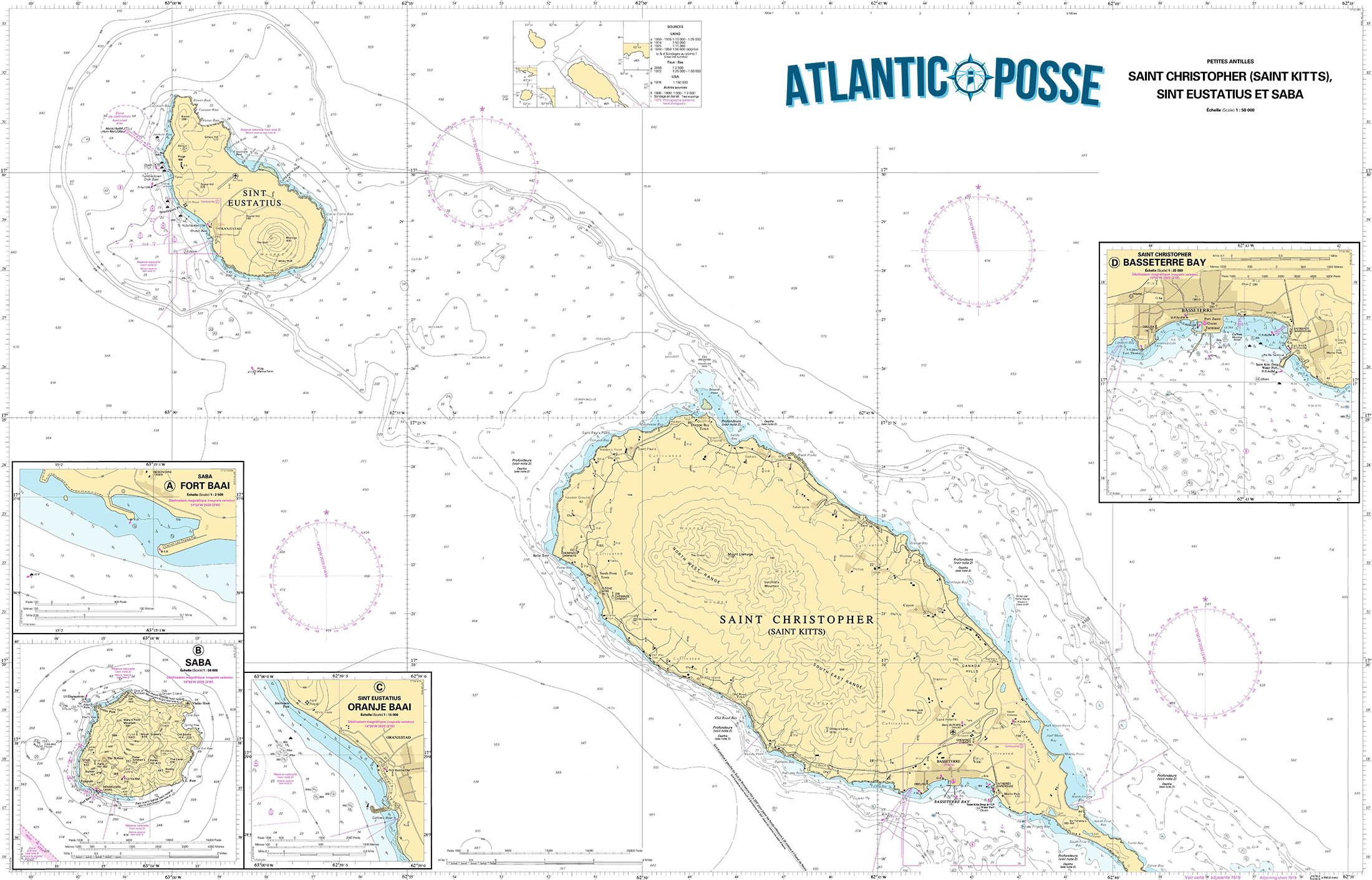
SABA 🇳🇱
 Tucked away in the northeastern Caribbean, Saba Island is one of the most remarkable yet lesser-known destinations in this region. As a captain, steering towards this volcanic peak rising from the ocean is an experience that evokes both anticipation and admiration. Saba, often referred to as the “Unspoiled Queen,” is part of the Netherlands Antilles and offers a pristine and authentic Caribbean experience that’s becoming increasingly rare in the region.
Approaching Saba: A Test of Skill
Navigating to Saba requires precision and respect for the island’s unique topography and weather patterns. The island, with its steep cliffs and lack of natural harbors, is not for the faint-hearted or the inexperienced mariner. Approaching from the southeast, you’ll be greeted by the towering Mount Scenery, a dormant volcano that is the highest point in the Netherlands. The island’s coastline is rugged, with waves crashing against sharp rocks and the occasional black sand beach peeking through the cliffs.
Given its small size—just five square miles—Saba is surrounded by deep waters. This means that the approach to Saba requires careful attention to charts, weather conditions, and tidal movements. The island lacks extensive coral reefs or sandbanks that many Caribbean sailors might be used to, which simplifies navigation but requires a cautious approach due to the steep underwater drop-offs close to shore.
Mooring at Saba
The island’s only official point of entry for vessels is Fort Bay, located on the southwestern coast. Fort Bay is a small and practical harbor, home to a few commercial docks and a handful of mooring buoys maintained by the local government. Because of the island’s rugged coastline, anchoring is not allowed, and visitors must use one of these buoys. It’s advisable to contact the harbor in advance to ensure availability, especially during peak season.
Mooring here is a skillful task, given the potential for strong currents and winds funneled between the cliffs. The bay is protected, but not immune to the surge from the open sea, making it imperative to check the weather forecast before arrival. Once securely moored, the first breath you take is a combination of relief and awe—the beauty of Saba lies in its untouched wilderness and the sense of remoteness that permeates the air.
Onshore Experience: A Journey Back in Time
Stepping ashore in Saba feels like entering a different era. The island’s four quaint villages—The Bottom, Windwardside, St. Johns, and Zion’s Hill—are connected by narrow, winding roads that cling to the steep slopes. These roads were constructed by hand by the island’s residents, a testament to their resilience and dedication. For captains and their crews, the exploration of these villages is a must.
The Bottom, the island’s capital, is the most accessible from Fort Bay. It’s a small, picturesque town with red-roofed houses, lush gardens, and friendly locals who greet visitors with a warmth that’s becoming rare in more commercialized parts of the Caribbean. Despite its name, The Bottom sits at an elevation of about 800 feet above sea level, offering panoramic views of the surrounding ocean.
Windwardside, located further up the slopes, is another highlight. This village is the heart of Saba’s tourism, where you’ll find small hotels, charming guesthouses, and a handful of restaurants offering local cuisine. The Saba lacework, a traditional craft passed down through generations, is a unique souvenir that visitors can take home as a reminder of this tranquil island.
Hiking and Exploration: The Crown Jewel of Saba
For those who enjoy the great outdoors, Saba is a paradise. The island’s rugged terrain offers some of the best hiking in the Caribbean. The crown jewel of Saba’s hiking trails is the climb to the summit of Mount Scenery. At 2,910 feet, it’s the highest point in the Dutch Kingdom, and the trail to the top is a challenge that rewards you with breathtaking views. The trail is well-marked but steep, with 1,064 steps leading through dense rainforest to the summit. On a clear day, you can see the neighboring islands of St. Eustatius, St. Kitts, and even St. Barths.
For captains and crew members looking to stretch their legs after days at sea, this hike is a perfect way to immerse yourself in Saba’s natural beauty. The island’s flora and fauna are remarkable, with over 200 species of plants and a rich diversity of birdlife. The trail to Mount Scenery is often shrouded in mist, adding a mystical quality to the journey.
Diving in Saba: A Subaqueous Adventure
Beyond the surface, Saba is renowned for its exceptional diving opportunities. The Saba Marine Park, established in 1987, surrounds the island and offers some of the most pristine dive sites in the Caribbean. The island’s volcanic origins have created a unique underwater landscape of pinnacles, coral gardens, and steep drop-offs.
One of the most famous dive sites is the Pinnacles, a series of underwater mountains that rise dramatically from the ocean floor. These pinnacles are teeming with marine life, from colorful coral formations to large schools of tropical fish, sharks, and rays. For experienced divers, the thrill of exploring these deep-water sites is unparalleled.
As a captain, facilitating a diving excursion for your crew or guests is an opportunity to showcase the hidden wonders of Saba. Local dive shops, such as Sea Saba and Saba Divers, offer guided dives and equipment rentals. It’s important to coordinate with these operators in advance, as diving in Saba requires adherence to strict environmental guidelines to protect the fragile marine ecosystem.
The Allure of Isolation
One of the most striking aspects of Saba is its sense of isolation. Unlike other Caribbean islands, where tourism is a dominant force, Saba has remained largely untouched by mass tourism. There are no large resorts, no bustling beaches, and no shopping malls. Instead, you’ll find an island that moves at its own pace, where the natural environment and the local culture are deeply intertwined.
For captains and sailors, this sense of isolation is both a challenge and a reward. Saba is a place where you can disconnect from the outside world, where the only sounds are the wind in the trees and the waves against the rocks. It’s a place that invites introspection and a deeper connection with the sea.
Practical Considerations for Visiting Captains
While Saba’s charm lies in its remoteness, this also means that certain practical considerations must be taken into account. Provisioning on the island is limited, so it’s essential to stock up on supplies before arrival. Fuel is available at Fort Bay, but it’s recommended to refuel at a larger port before heading to Saba.
Communication can also be a challenge. While the island has decent cellular coverage, internet access can be slow and unreliable. For captains who rely on digital navigation tools and weather updates, it’s wise to download necessary data before approaching the island.
Lastly, it’s important to respect the local regulations, particularly those related to environmental protection. Saba’s government and residents are committed to preserving the island’s natural beauty, and visiting sailors are expected to do their part. This includes proper waste disposal, adherence to mooring guidelines, and respecting the marine park’s no-anchor zones.
Departure: Leaving the Unspoiled Queen
Departing from Saba is a bittersweet experience. As you release the mooring and navigate away from the island’s dramatic coastline, there’s a sense of having discovered a place that few others have. Saba’s rugged beauty, its welcoming communities, and its unspoiled nature leave a lasting impression on those who venture to its shores.
For a captain, Saba is more than just a stopover; it’s a destination that challenges your skills, enriches your journey, and reminds you of the simple, untamed beauty that the Caribbean can still offer. As the island fades into the horizon, there’s a quiet understanding that Saba will remain one of those rare places—a true gem of the sea, cherished by those who have had the privilege to experience it.
In the end, Saba is a testament to the enduring allure of the sea and the islands that rise from it. It’s a place where the spirit of exploration lives on, where the call of the ocean meets the whispers of the wind, and where a captain can find not just a destination, but a profound connection to the world and its wonders.
MARINAS
Saba is a unique destination in the Caribbean due to its rugged terrain and lack of natural harbors, which limits the availability of traditional marinas. The island has only one official point of entry and limited facilities for yachts and boats:
1. Fort Bay Harbor
- Location: 17°37’36.0″N 63°14’13.0″W
- Description: Fort Bay Harbor is the only port and official entry point for vessels on Saba. It is located on the southwestern side of the island. The harbor primarily serves commercial and government vessels but provides limited services for visiting yachts. The harbor is small and can accommodate only a few vessels at a time. Mooring buoys are available in the harbor for visiting boats, as anchoring is not allowed due to the steep underwater drop-offs and to protect the marine environment.
- Facilities: The facilities are minimal, with basic services available, including fuel, water, and customs/immigration clearance. There is a small pier for loading and unloading supplies. However, there are no extensive marina facilities such as repair services or chandlery.
- Contact Information: It’s recommended to contact the harbor authorities in advance to arrange for mooring and entry procedures. Saba’s Marine Park Office also assists with mooring information and regulations.
Key Considerations:
- Mooring: Due to the limited space and facilities, it’s essential to secure a mooring buoy ahead of time, especially during peak seasons. Anchoring is prohibited around the island to protect the coral reefs and marine environment.
- Provisioning: Saba has limited resources, so it’s advisable to provision before arrival. There are a few small grocery stores on the island, but options are limited.
- Fuel: Available at Fort Bay Harbor, but supply can be limited, so plan accordingly.
- Customs and Immigration: All vessels must check in at Fort Bay Harbor, where customs and immigration procedures can be completed.
WEATHER
MAIN LOCAL WEATHER WEBSITE SABA 🇳🇱
SEVERE WEATHER SABA 🇳🇱
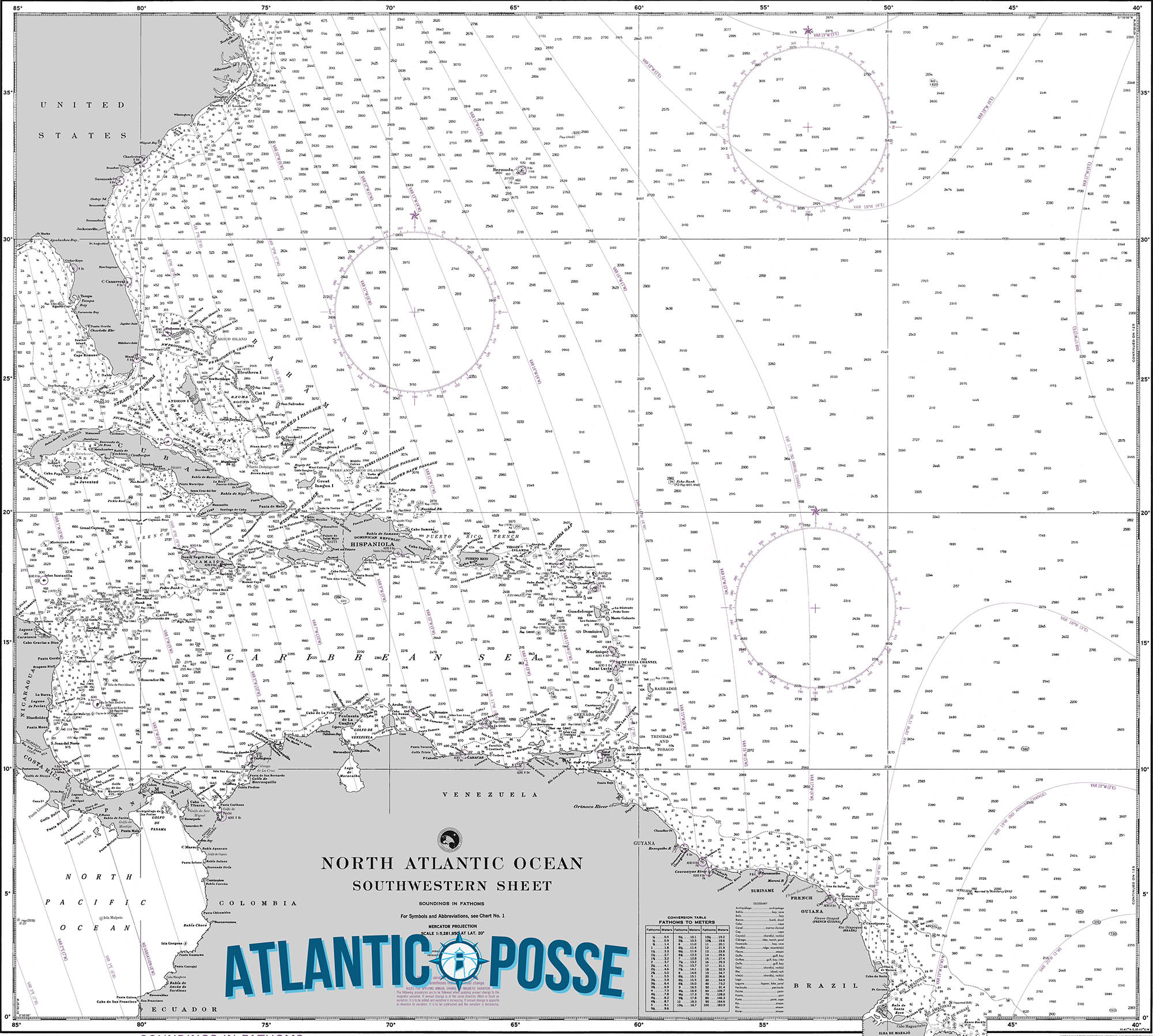
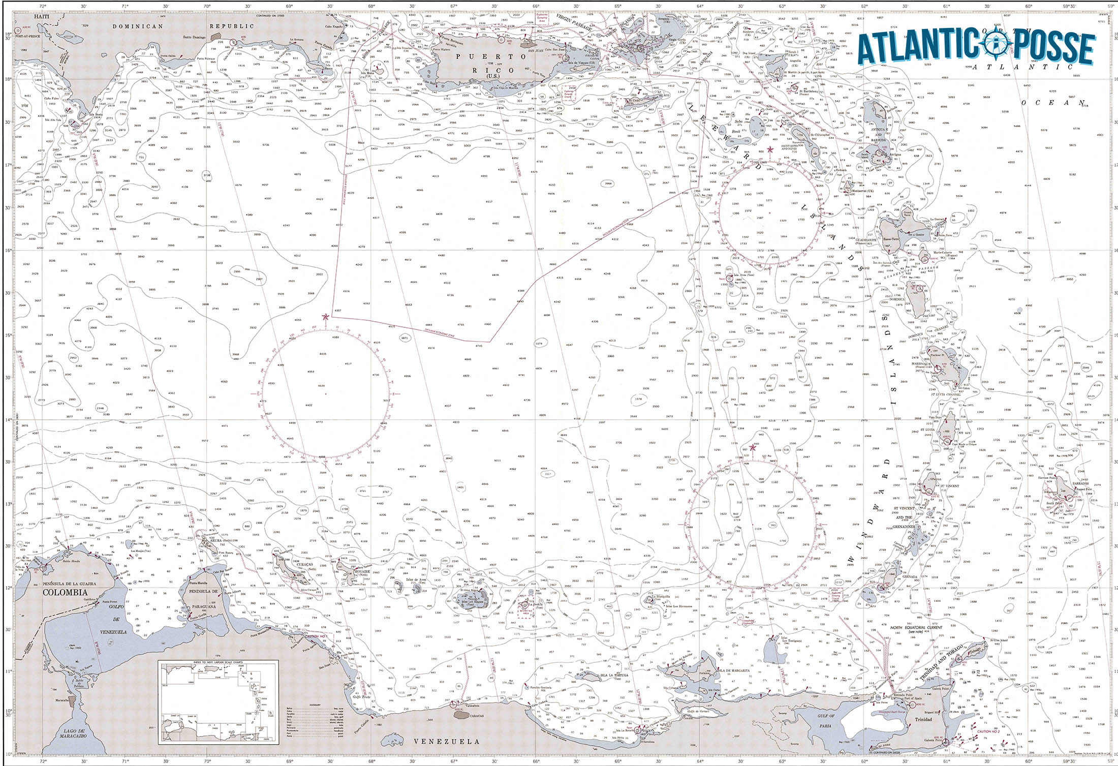
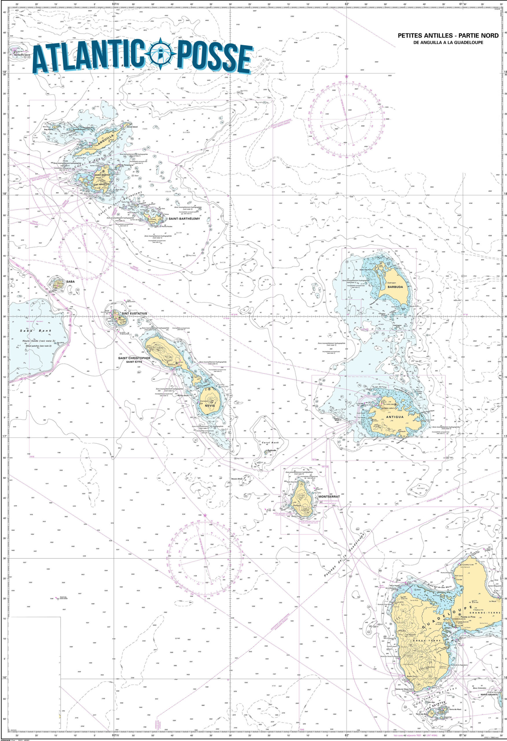
PILOT CHARTS
PORTS OF ENTRY
Saba is a unique destination in the Caribbean due to its rugged terrain and lack of natural harbors, which limits the availability of traditional marinas. The island has only one official point of entry and limited facilities for yachts and boats:
1. Fort Bay Harbor
- Location: 17°37’36.0″N 63°14’13.0″W
- Description: Fort Bay Harbor is the only port and official entry point for vessels on Saba. It is located on the southwestern side of the island. The harbor primarily serves commercial and government vessels but provides limited services for visiting yachts. The harbor is small and can accommodate only a few vessels at a time. Mooring buoys are available in the harbor for visiting boats, as anchoring is not allowed due to the steep underwater drop-offs and to protect the marine environment.
- Facilities: The facilities are minimal, with basic services available, including fuel, water, and customs/immigration clearance. There is a small pier for loading and unloading supplies. However, there are no extensive marina facilities such as repair services or chandlery.
- Contact Information: It’s recommended to contact the harbor authorities in advance to arrange for mooring and entry procedures. Saba’s Marine Park Office also assists with mooring information and regulations.
Key Considerations:
- Mooring: Due to the limited space and facilities, it’s essential to secure a mooring buoy ahead of time, especially during peak seasons. Anchoring is prohibited around the island to protect the coral reefs and marine environment.
- Provisioning: Saba has limited resources, so it’s advisable to provision before arrival. There are a few small grocery stores on the island, but options are limited.
- Fuel: Available at Fort Bay Harbor, but supply can be limited, so plan accordingly.
- Customs and Immigration: All vessels must check in at Fort Bay Harbor, where customs and immigration procedures can be completed.
MUST SEE
1. Mount Scenery
- Location: 17°37’31.2″N 63°14’50.4″W
- Description: Mount Scenery, standing at 2,910 feet, is the highest point in the Netherlands and the Caribbean. This dormant volcano offers one of the most rewarding hikes in the region. The trail leading to the summit starts in Windwardside and takes you through lush rainforests filled with exotic flora and fauna. As you ascend the 1,064 steps, you’ll be enveloped in a mystical cloud forest. The summit, often shrouded in mist, offers breathtaking views on clear days, with sights extending to neighboring islands like St. Eustatius and St. Kitts. This hike is a must for any nature lover or adventurer visiting Saba.
- Best Time to Visit: The best time to hike Mount Scenery is during the dry season, from December to April, when the trail is less slippery, and the weather is cooler.
2. Saba Marine Park
- Location: 17°37’24.0″N 63°14’06.0″W
- Description: Established in 1987, the Saba Marine Park surrounds the entire island and is a sanctuary for marine life. The park is renowned for its pristine dive sites, including the famous Pinnacles, underwater mountains that rise from the deep ocean floor. The park’s clear waters, healthy coral reefs, and abundant marine species make it a diver’s paradise. Whether you’re diving or snorkeling, you’ll encounter vibrant coral gardens, tropical fish, sea turtles, and even sharks. The park is meticulously maintained, with strict regulations to preserve its beauty for future generations.
- Best Time to Visit: The best time to visit Saba Marine Park is from December to May, when sea conditions are calm, and visibility is at its best.
3. The Bottom
- Location: 17°37’45.6″N 63°14’49.2″W
- Description: The Bottom is the quaint capital of Saba, nestled in a valley surrounded by steep hills. This village is the administrative heart of the island and home to Saba University School of Medicine. Its charming red-roofed houses, manicured gardens, and friendly locals give The Bottom a warm, welcoming atmosphere. Key sites include the historic Dutch Reformed Church, built in 1919, and the Saba Archaeological Center, which offers insights into the island’s rich history. The Bottom is a perfect place to start your exploration of Saba and to experience the island’s unique culture and community.
- Best Time to Visit: The Bottom can be visited year-round, but the dry season from December to April offers more comfortable weather for exploring the village.
4. Windwardside
- Location: 17°37’54.0″N 63°13’59.4″W
- Description: Windwardside is one of the most picturesque villages on Saba, perched high on the slopes of Mount Scenery. This vibrant village is the heart of Saba’s tourism, with charming guesthouses, restaurants, and shops selling local crafts such as Saba lace. Windwardside offers stunning views of the surrounding hills and ocean, and it’s the starting point for many of the island’s hiking trails. Notable sites include the Saba Museum, which showcases the island’s cultural heritage, and the trailhead for the Mount Scenery hike. Windwardside is the perfect base for exploring the natural and cultural treasures of Saba.
- Best Time to Visit: Visit Windwardside from December to April, when the weather is cooler, and the skies are clear, offering the best views.
5. Tide Pools at Flat Point
- Location: 17°38’06.0″N 63°14’10.8″W
- Description: The Tide Pools at Flat Point offer a unique opportunity to explore Saba’s volcanic coastline. These natural pools are formed by the ocean’s waves crashing into the rocky shore, creating isolated pools filled with marine life. Exploring the tide pools is a fascinating experience, especially during low tide when the pools are more accessible. The pools are teeming with small fish, crabs, and other sea creatures, making it a great spot for nature enthusiasts and photographers. The dramatic backdrop of the cliffs and the sound of the ocean create a serene, otherworldly atmosphere.
- Best Time to Visit: The best time to visit the tide pools is during low tide and calm seas, which are most common from December to April.
6. Ladder Bay
- Location: 17°38’15.0″N 63°14’52.8″W
- Description: Ladder Bay is a historic site on Saba’s western coast, where goods and people were once transported to and from the island before Fort Bay Harbor was constructed. The “Ladder” refers to the steep set of stone steps carved into the cliff, leading from the bay to the village above. Although the climb is challenging, the views from the top are spectacular. The bay itself is a popular spot for snorkeling and diving, offering clear waters and an abundance of marine life. Ladder Bay is a place where history and nature converge, providing a glimpse into Saba’s past and its natural beauty.
- Best Time to Visit: The best time to visit Ladder Bay is from December to April, when the seas are calm, making it easier to explore the bay’s underwater treasures.
7. Troy Hill
- Location: 17°38’30.0″N 63°13’54.0″W
- Description: Troy Hill is a lesser-known but equally captivating spot on Saba. Located near the village of Hell’s Gate, this hill offers panoramic views of the island’s northern coastline and the neighboring island of St. Eustatius. The hike to Troy Hill is moderate, taking you through Saba’s lush, unspoiled landscapes. Along the way, you’ll encounter diverse plant life and may spot some of the island’s resident bird species. At the summit, you’re rewarded with a sense of tranquility and awe as you take in the sweeping views of the Caribbean Sea and the surrounding islands.
- Best Time to Visit: The best time to hike Troy Hill is during the dry season, from December to April, when the trail is in its best condition.
SERVICES & REPAIRS
given its small size and rugged terrain, has limited marine services compared to larger Caribbean islands. However, the island does offer essential services for visiting yachts and boats, particularly in and around Fort Bay Harbor, the main point of entry for vessels. Here’s an overview of the marine services available on Saba:
1. Mooring Buoys
- Location: Fort Bay Harbor, 17°37’36.0″N 63°14’13.0″W
- Description: Due to the steep underwater drop-offs around Saba, anchoring is prohibited. Instead, the island provides several mooring buoys in Fort Bay Harbor for visiting yachts. These moorings are well-maintained and suitable for vessels of varying sizes. It’s advisable to contact the harbor in advance to ensure availability, especially during peak season.
2. Fuel and Water
- Location: Fort Bay Harbor
- Description: Fuel is available at Fort Bay Harbor, though the supply can sometimes be limited, so it’s recommended to refuel before arriving in Saba. Water is also available at the harbor, but visitors should be mindful that water is a precious resource on the island, especially during the dry season.
3. Customs and Immigration Services
- Location: Fort Bay Harbor
- Description: All vessels must check in at Fort Bay Harbor, where customs and immigration services are available. The office is located near the dock, and the process is straightforward, with officials typically available during standard business hours. It’s recommended to have all necessary documentation ready, including passports, vessel registration, and crew lists.
4. Marine Park Regulations and Services
- Location: Saba Marine Park Office, Fort Bay Harbor
- Description: The Saba Marine Park office, located near Fort Bay, provides information and services related to the marine environment. This includes issuing permits for diving and providing guidelines on the use of mooring buoys. The park is highly protected, so all activities must comply with regulations designed to preserve the marine ecosystem.
5. Provisions and Supplies
- Location: Various small shops in The Bottom and Windwardside
- Description: Saba has a few small grocery stores in The Bottom and Windwardside where basic provisions can be purchased. However, given the limited supply, it’s advisable to stock up on essentials before arriving on the island. Specialty items and extensive provisions may not be available.
6. Waste Disposal
- Location: Fort Bay Harbor
- Description: Waste disposal services are available at Fort Bay Harbor, but visitors are expected to follow strict guidelines to protect the island’s environment. Recycling and proper waste management are emphasized, and all visitors are encouraged to minimize their environmental impact.
7. Diving Services
- Location: Windwardside
- Description: Saba is renowned for its diving, and there are a few dive shops, such as Sea Saba and Saba Divers, that offer guided dives, equipment rental, and dive certification courses. While these services are not directly marine services, they are essential for visitors interested in exploring Saba’s underwater attractions.
8. Emergency and Rescue Services
- Location: Fort Bay Harbor
- Description: Saba has a basic emergency response system in place, with services coordinated through the harbor and local authorities. While the island does not have extensive marine rescue facilities, it is part of the regional maritime network, which can be called upon in case of emergency.
EMERGENCIES AND SAR INFO
Saba officials listening to a presentation about the search and rescue boat.
SABA–The public entity of Saba announced on Wednesday that it is slated to receive a search and rescue (SAR) boat in the first half of 2025, which will be used to assist people who need help in Saban waters.
The boat, funded by the Dutch Ministry of Infrastructure and Water Management, was highlighted as a local need following research conducted in 2018 and 2019 by Dutch civil servant Marius Sliedrecht.
According to Saba, there will be a budget for the vessel and its maintenance, as well as for professional equipment, annual training for its crew and the establishment of a management organisation. This was based on a plan drafted in 2021 and 2022 by project leader Hans Schreuder.
“The launch of a SAR vessel marks a significant enhancement in the safety for both residents and visitors, fulfilling a long-awaited request from Saba,” Saba said in a press release on Wednesday. “The importance of the vessel cannot be overstated, as in cases of emergencies the reaction time of the Dutch Caribbean Coast Guard may be lengthy and there are currently no formalised SAR operations on Saba, increasing the risk of those in distress while at sea.”
Airport Manager Maegan Hassell said the vessel will ensure Saba fulfils the requirement of the International Civil Aviation Organization (ICAO) that obliges airports close to water to have specialist aquatic rescue services readily available.
The vessel – a Habbeké Fast Rescue Craft 903 – will be a 30-foot boat and, according to the release, will be specifically crafted to handle Caribbean waters, as well as strong winds, high temperature and the salt from the ocean.
It will have the capacity to carry 21 persons in addition to four members of the rescue team. The boat will have two Volvo Penta engines and will be fitted with jets instead of propellers for “safety reasons”, the release said, adding that a similar vessel is currently being used by Curaçao’s civil rescue organisation.
“The boat should take between nine and 12 months to be built, with the goal of being fully operational within the first half of 2025,” according to the press release.
Saba said training in SAR operations will be offered to a crew of four, but the goal is to grow to eight crew members in total. The training will be done in collaboration with volunteer group Royal Dutch Sea Rescue, who will facilitate certified training for Saba and St. Eustatius in their respective local waters.
“Further collaboration between Saba and St. Eustatius will occur through management and sharing technical and maintenance capacity,” according to the release.
Saba Island Governor Jonathan Johnson thanked the Dutch Ministry of Infrastructure and Water Management for funding the initiative, and Schreuder for “involving the stakeholders during the process.”
“We realise the local situation and the need to ensure international requirements are met. Through patience and persistence, we will actualise a necessary resource for our island,” said Johnson.

Getting Ready to GO Cruising!
Getting Ready to GO!
by Ocean Posse member Rob Murray on SV AVANT

What do you do to get ready for a cruising season? What resources do you rely on? How can you assess the weather and potential passages months in advance? The following is a list of some of the steps we take and resources we rely on aboard Avant to get ready for a major passage that’s a few months down the line, or to get ready for a season of sailing.
First, we have a look at Jimmy Cornell’s World Cruising Routes, a staple reference guide for cruisers. While a great resource, this book is a, “comprehensive guide to over 1,000 routes covering all the oceans of the world from the tropical South Seas to the high-latitudes of the Arctic and Antarctic” – all in some 600-odd pages. While it provides breadth, it is somewhat lacking in depth. It suffers to some degree from the source of data, which is a mix of pilot charts and books overlaid heavily with the personal experience of many seasoned cruisers. Since some areas are not frequented by cruisers for various reasons, they are often omitted (for example, the 1987 edition omitted Colombia, since it was so dangerous it seemed no one cruised there). Also, since Cornell’s other endeavors (such as founding the Atlantic Rally for Cruisers [ARC]) have been long distance and circumnavigation focused, it often misses out on more coastal routes. Nonetheless, it is always our first stop for a broad overview.

Cornell does focus on the passage part of the planning and has virtually no information on local conditions to expect when you have arrived.
Regarding our plan to leave Panama, Cornell says, “Eastbound Passages from Panama can be extremely difficult at all times of the year, because of the prevailing direction of the winds and current” and that “better and more comfortable passages have been made in late spring or early summer”. Good to know.
Before Cornell wrote his guides, sailors relied on Ocean Passages for the World, publication NP136 from the British Admiralty. I think the 3rd edition of 1973 was the last to feature separate routing advice for sailing ships and power vessels (newer editions omit advice for sailing ships). It builds on the 1895, 1923 and 1960 editions and is the last Admiralty guide written for professional world sailors (the iron men in wooden ships). PDF versions can be found online and make interesting and instructive reading. While the sailing directions are directed for full rigged tall ships, they suit modern sailors because, although we may be able to sail upwind, none of us much like it. While I enjoy referring to it, I should note that its precision and brevity make Cornell look positively loquacious.

Next, we go shopping at the NGA store (National Geospatial-Intelligence Agency) is a support agency of the United States Department of Defense with the primary mission of collecting, analyzing, and distributing geospatial intelligence (GEOINT)). If the US Navy gave you command of a destroyer and said ‘go there’, the NGA would provide the travel guidebooks. The NGA annual budget is classified, but was estimated to be at least $4.9 billion in 2013. It is nice to be able to add that kind of horsepower to your cruising budget.
We get the Sailing Directions (Enroute) for our area (these include:
“detailed coastal and port approach information, supplementing the largest scale chart of the area). Each publication is subdivided into geographic regions, called sectors, which contain information about the coastal weather, currents, ice, dangers, features and ports, as well as graphic keys to standard [MIMA/DMA] nautical charts available for the area.”
They have some photos, and some sketch charts. While mainly designed for much larger vessels, they are very handy. After the introductory chapter, the detailed description of the region begins. A map/chart precedes each chapter and outlines the nautical charts used in the area to be discussed. In these chapters, as much as possible, the coastal description is in geographic sequence and gazettes the coastline, ports, anchorages, navigation aids and hazards. These are fairly current: it is unusual to find one that hasn’t been updated in the last six months or so. For example, the 2017 Publication 148 was corrected (updated) through 26 September 2020 when I downloaded it in December 2020. Similar ADMIRALTY Sailing Directions are available from the UK Hydrographic Office, but they are priced at Hardback Paper Publication: £63.50, Electronic version (AENP): £38.70 per volume, so we don’t use those.

Both publications have some information on local conditions along the coast and note currents and weather systems with much more detail than other readily available sources.
For the western Caribbean, where Avant is now, the Sailing Directions (Enroute) tell us:
“The prevailing winds are the NE trades, which frequently assume a N or E direction, also a gusty character close inshore. These winds flow strongly from December to March”
and
“During the dry season [December to March], the winds are stronger”
and
“During the dry season, the wind may freshen to a velocity of 15 knots in the vicinity of the Panama Canal, but frequently exceeds 20 knots for a period of 24 hours or more. During the wet season in the same locality, the average wind velocity is about 8 knots, but greater velocities are experienced during passing local rain squalls.”
Hmmm. We are not fans of sailing to weather in strong or gusty winds; spring sounds much better.
We also get the Sailing Directions (Planning Guides) (these include, “relevant physical, political, industrial, navigational and regulatory information about the countries adjacent to a particular ocean basin in a single volume”). The information on each country is contained in a page or two. These are not hugely useful, but they do list national holidays and Search and Rescue (SAR) contact information for each country. You generally do not want to arrive on a holiday with the attendant overtime port fees, and while you don’t want to have to call SAR, if you do need to, it’s nice to have the number.

While you are in the NGA shop, you may as well get some other e-books that may be handy – the latest American Practical Navigator (Bowditch), the latest International Code of Signals (revised 2020 – you do have the new edition aboard, don’t you?), etc.
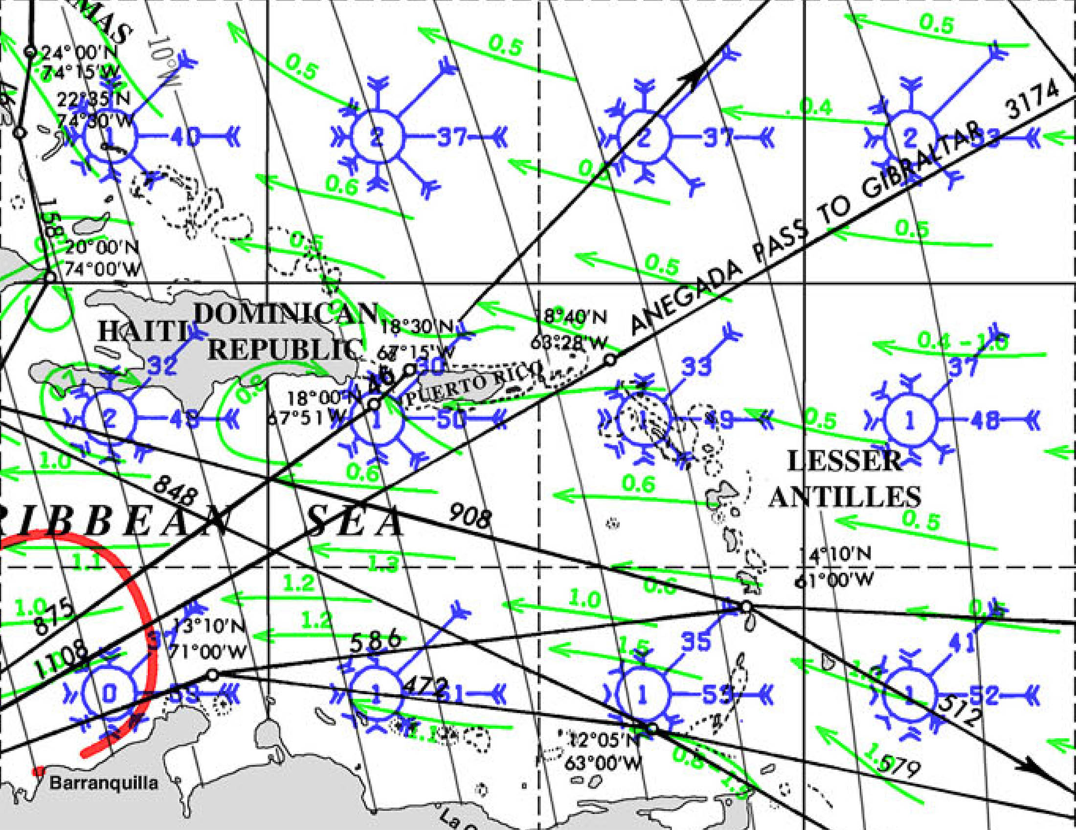
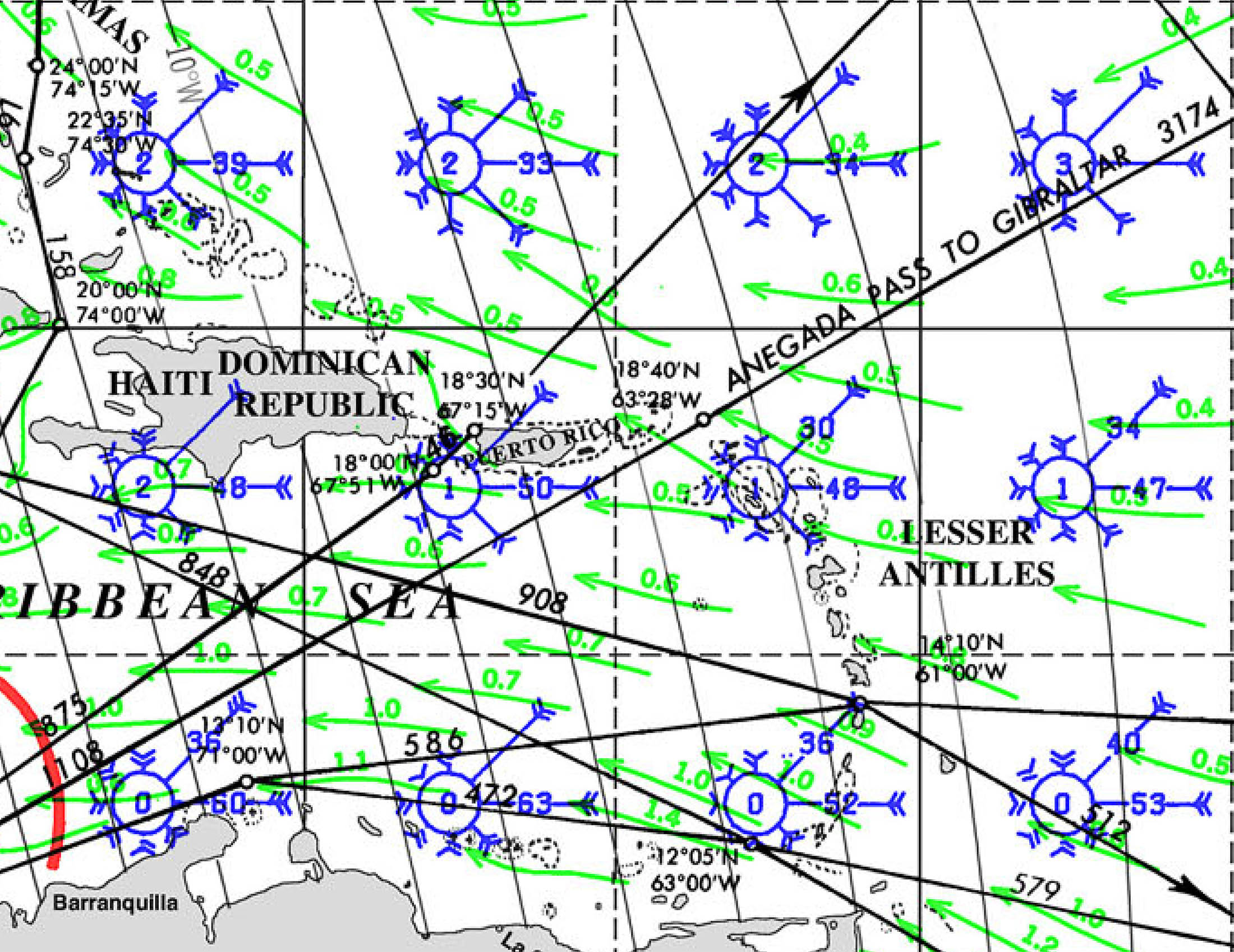
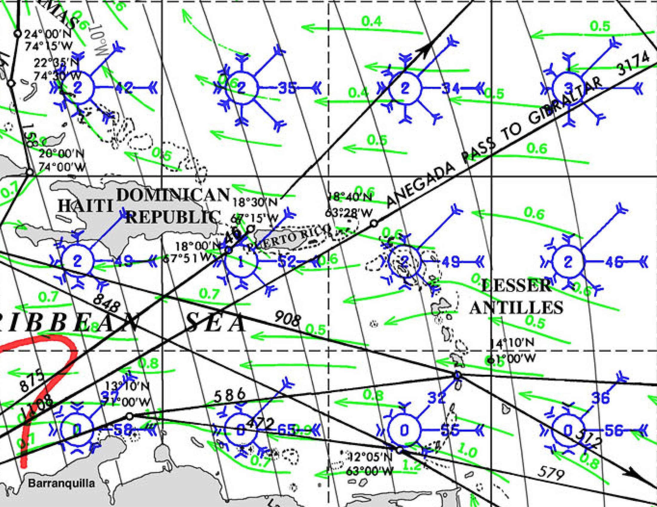
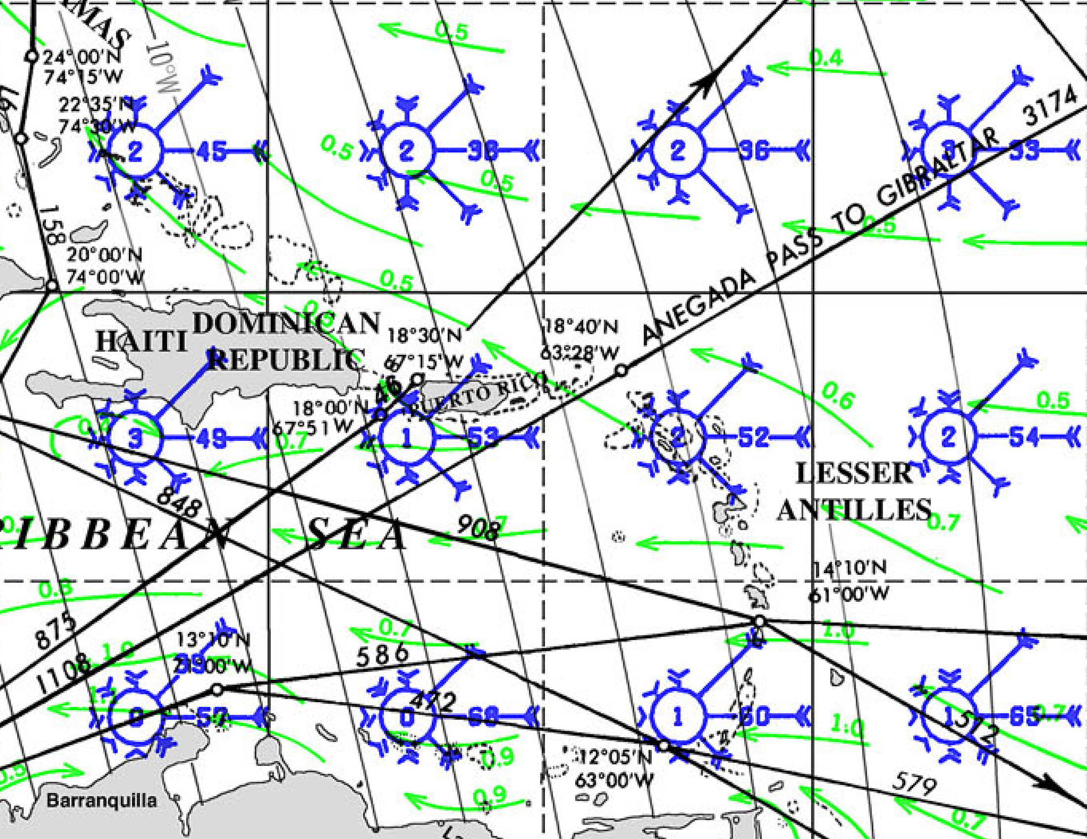
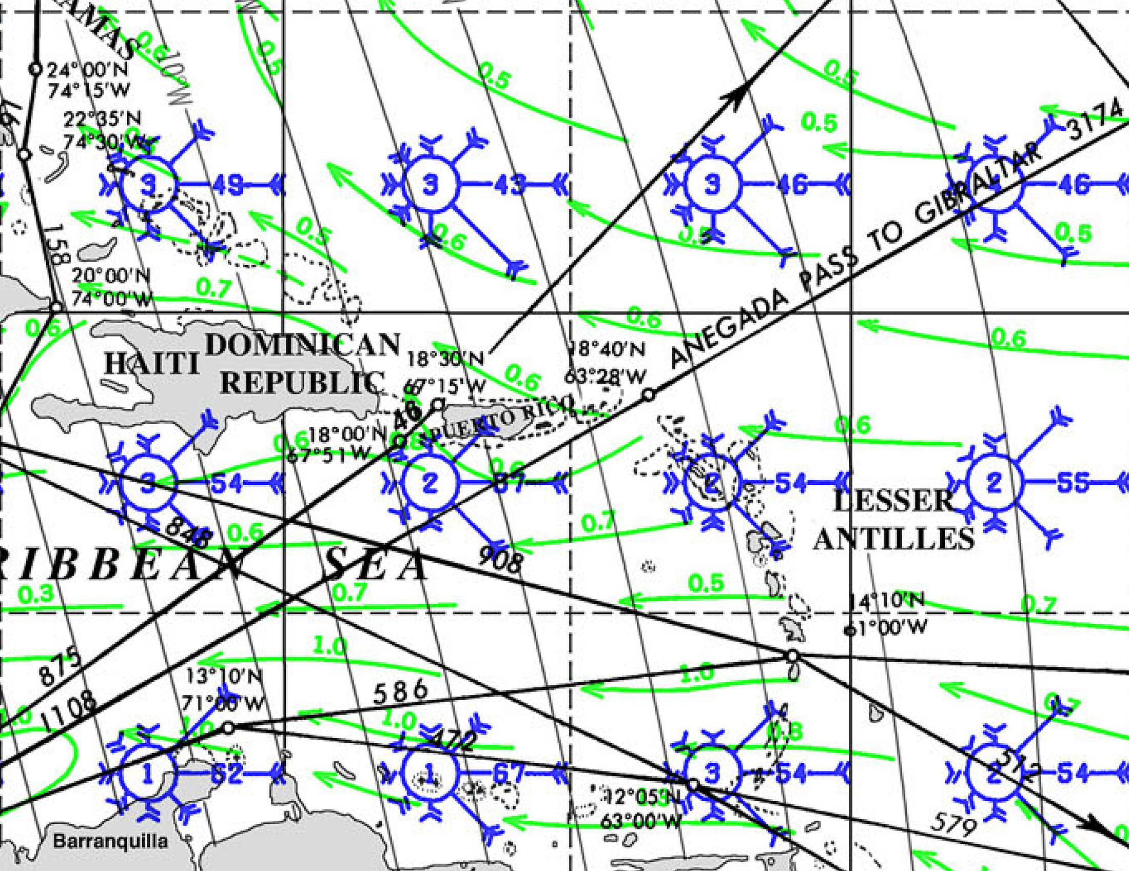
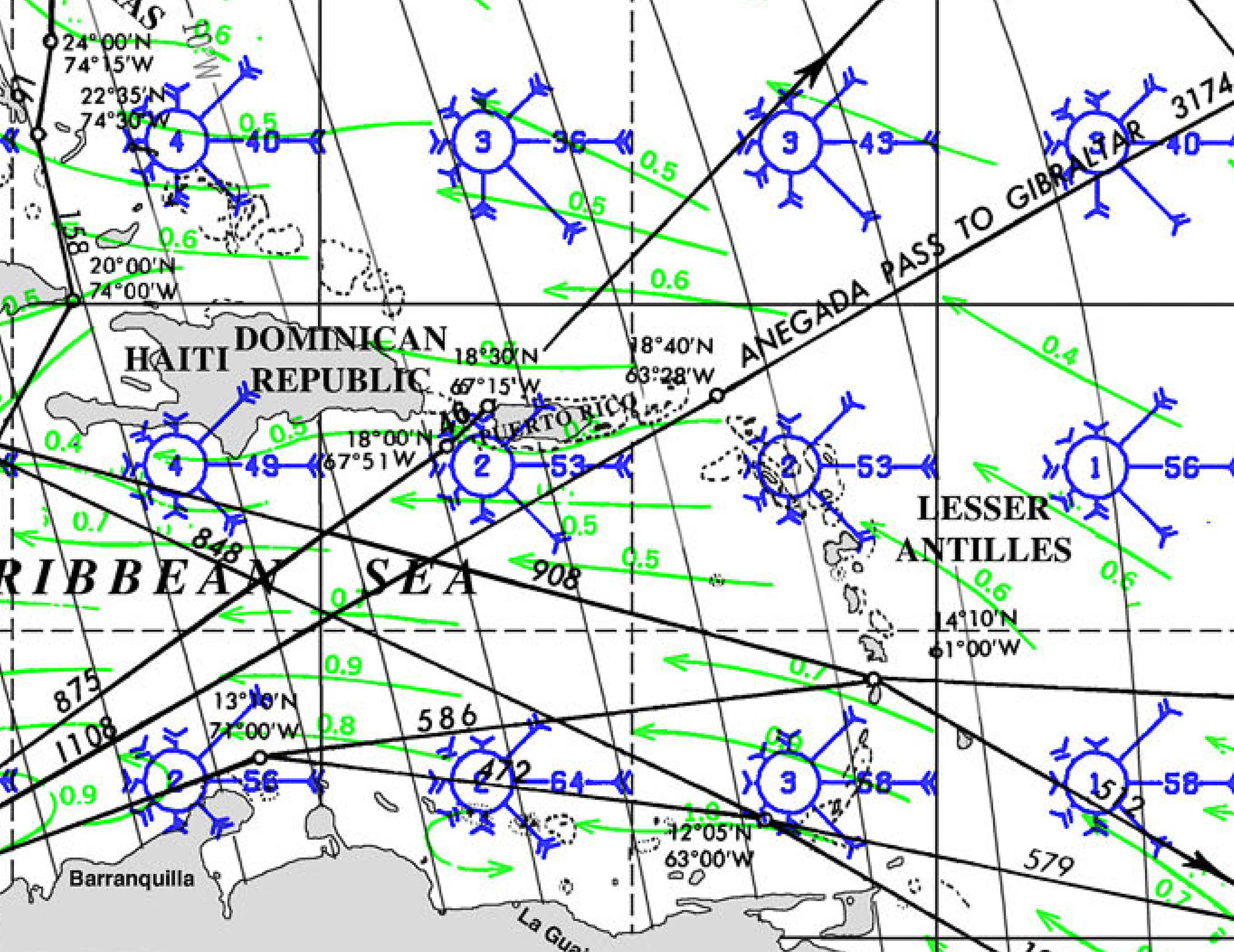
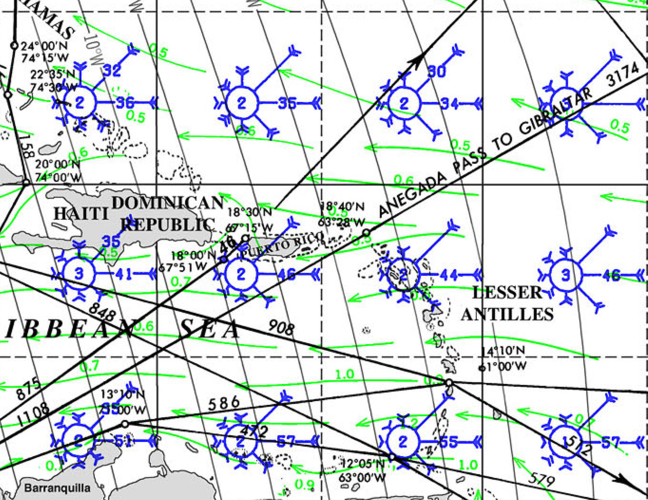
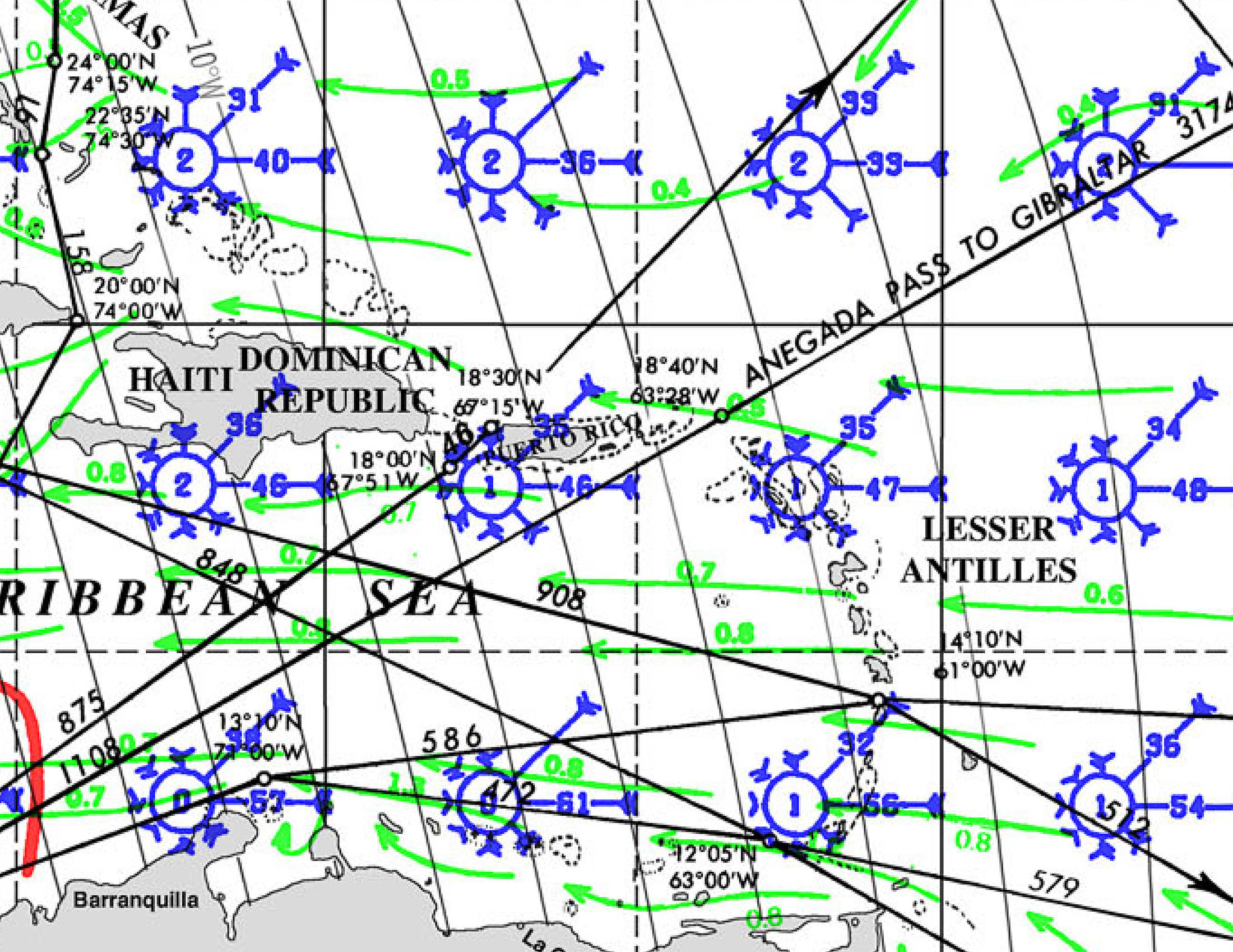
We want to review the Pilot Charts which:
“depict averages in prevailing winds and currents, air and sea temperatures, wave heights, ice limits, visibility, barometric pressure, and weather conditions at different times of the year. The information used to compile these averages was obtained from oceanographic and meteorologic observations over many decades during the late 18th and 19th centuries. The Atlas of Pilot Charts set is comprised of five volumes, each covering a specific geographic region. Each volume is an atlas of twelve pilot charts, each depicting the observed conditions for a particular month of any given year. The charts are intended to aid the navigator in selecting the fastest and safest routes with regards to the expected weather and ocean conditions.”
There are three main ways to get these, by:
- Buying paper copies at a chart dealer or online. (This is expensive and inconvenient, and a set is heavy to carry around for the use they get. They are rarely updated, however, so they will be current for many years). They are about $45.00 US per volume, plus shipping.
- Downloading the free PDF versions at the NGA. These are big PDF files, and some computers have difficulty managing them well. They are faithful copies of the paper charts and contain all the data.
- Downloading the free versions converted to *.BSB files for use within OpenCPN. The Chart Groups feature in OpenCPN is ideally suited for viewing and organizing Pilot Charts, but its often difficult to see the chart and the explanatory text or notes at the same time.
The downside of pilot charts is that they have been developed over many years and use data reaching back at least 100 years. Since a lot of the data is from pre-satellite times, they are primarily based on data derived from shipboard observations: since ships try to avoid areas of inclement weather, the observations tend to under-report gales and high waves, and the data quality for rarely travelled routes is poorer. The upside is that they combine a huge amount of data (tens of thousands of data points, if not millions combined in a very comprehensible format: wind, waves, currents, storm tracks, and more on a single page).
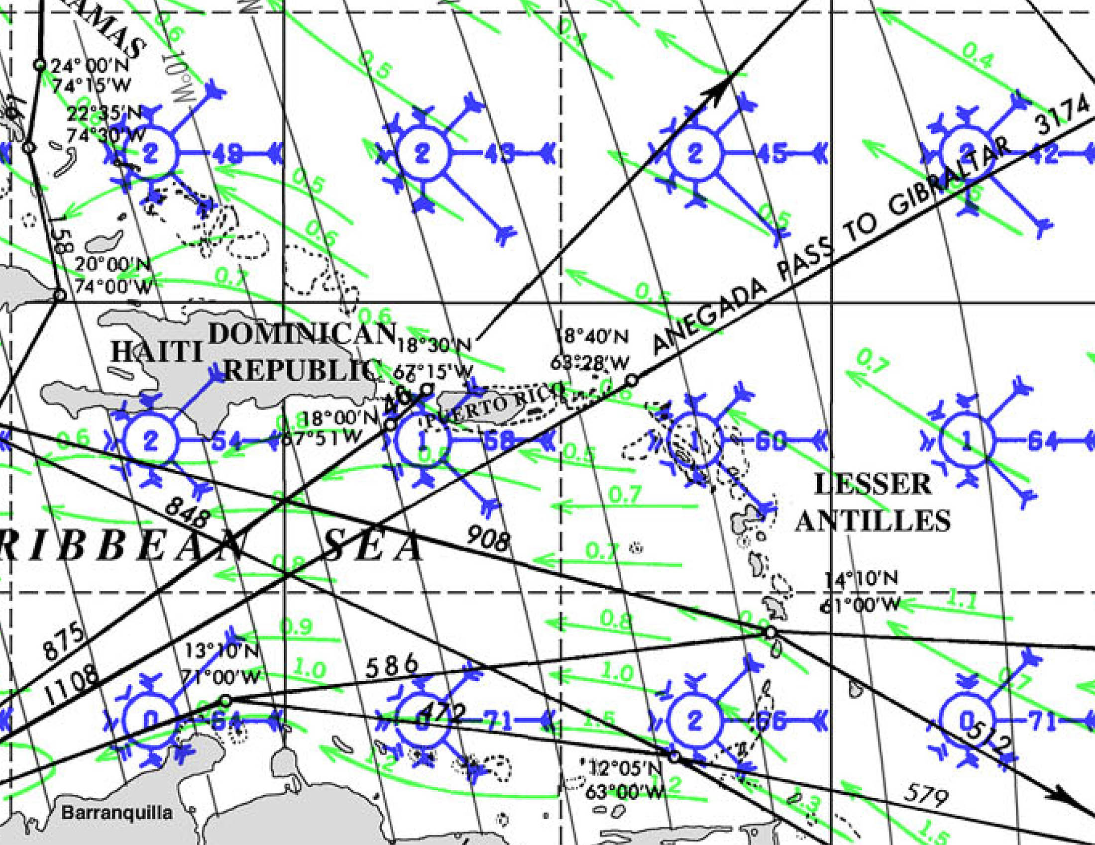
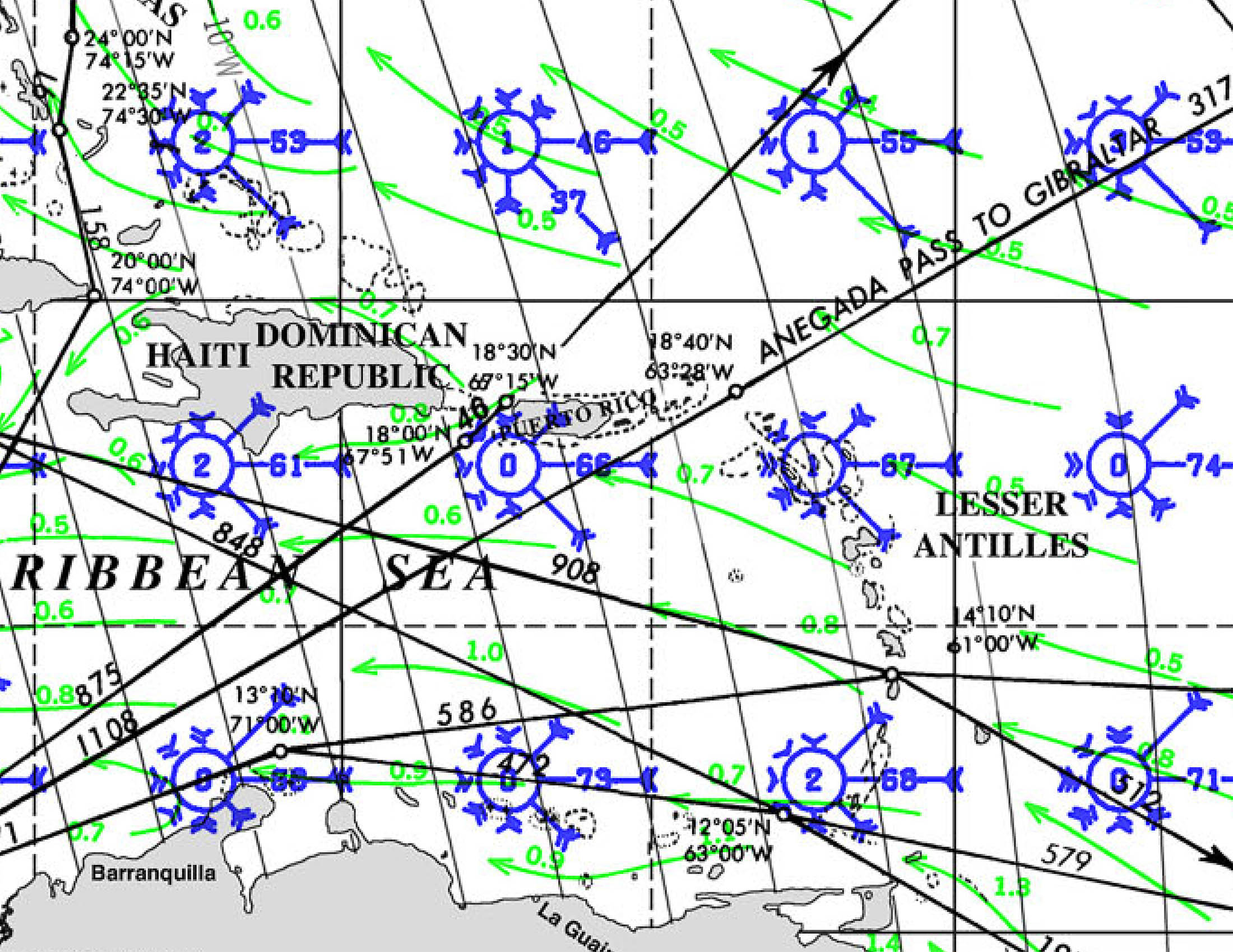
Here’s a view of the Pilot Chart for the western Caribbean in January:

Where the red arrow is (just North of Santa Marta Colombia) is the region with the strongest average winds, about 23 knots. Because the data is digital, we can move our cursor around to see the average winds are almost exactly 20 knots throughout the region, which makes a bit of a difference from the 17-21 in the pilot charts. Remember, if the average wind is 20 knots, about ½ the time it is stronger than that and about ½ the time it is less.
We also like to root around a bit in satellite data sets. You can review years of data for many satellites with disparate data sets at the NOAA portal. I don’t know what the combined budget is for this satellite array, but it’s a nice data set to have access to for free.
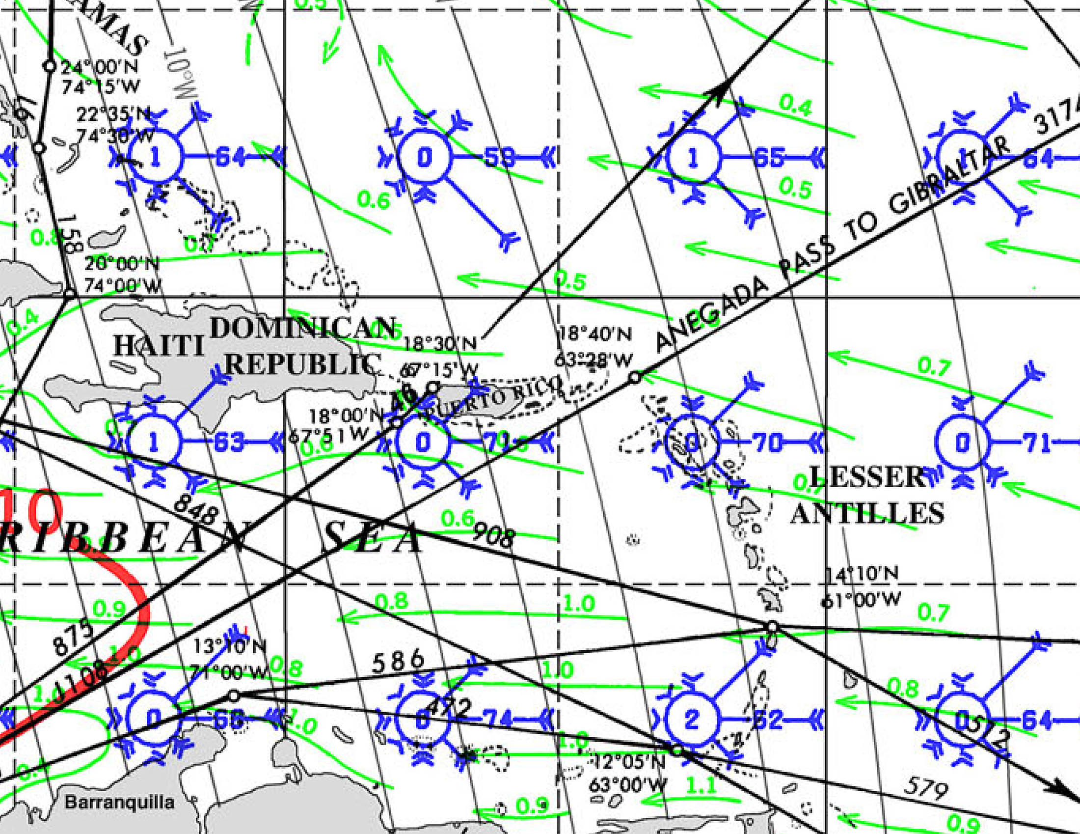
For example, if we want to know what the waves were like in the western Caribbean, January 2020 mid-month we go to this data set and can extract wave height data:

Hmmm . . . up to about 20-22’. That puts the fun meter pretty deep in the red, we should probably look at another month for that passage.
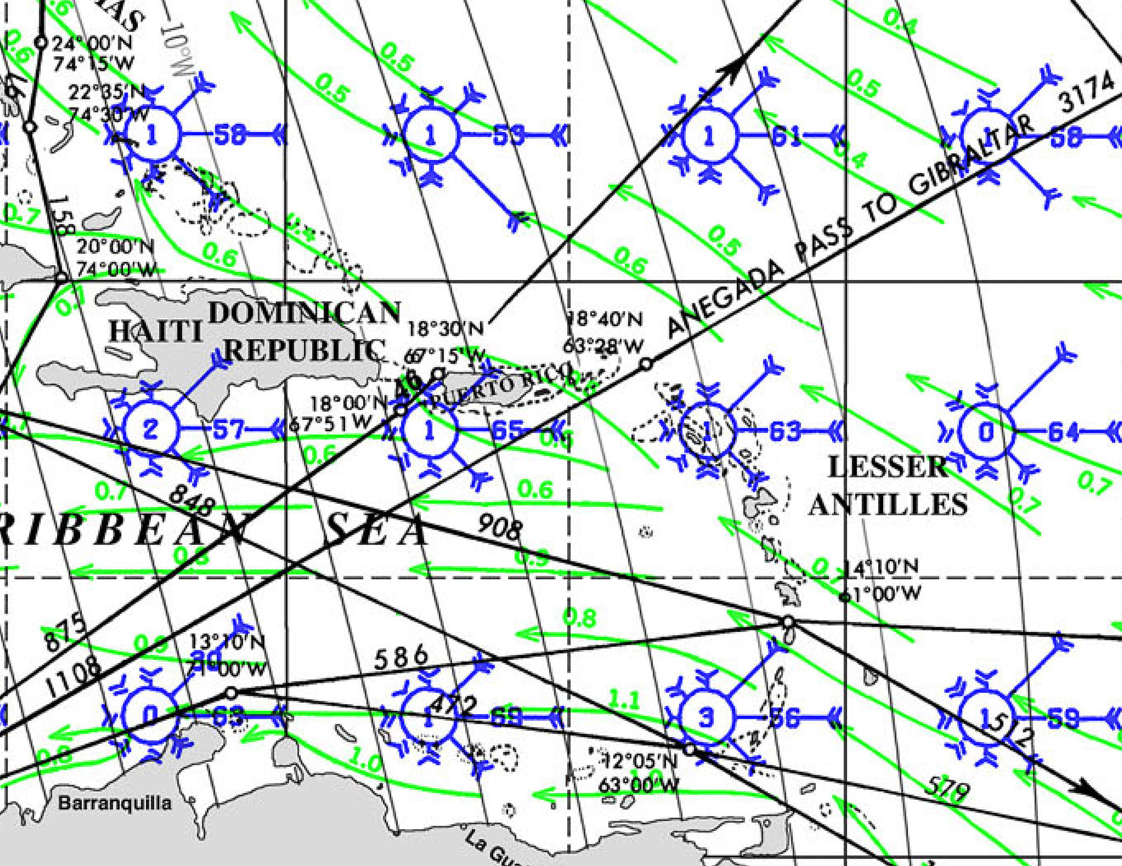
We can also go to this data set and extract the satellite wind data for the same date:

Positively sporty, that is. I’m not liking January for voyaging in the Western Caribbean.
We also try to find cruising guides. Cruising guides for different areas in the world vary tremendously in quality, and many are out of date. For some areas, they’re just not available. We have also found errors in waypoints and just plain bad advice in some, so do check the data and be careful. As Ronald Reagan said, “trust, but verify”. Sometimes you can find cruisers going ‘the other way’ that you can trade guidebooks and check guidebook reviews with.
I spend the time to find or make satellite charts for the cruising area to use in conjunction with OpenCPN, and download satellite views to the OvitalMap application on our tablets and in SASPlanet on our PC for reference. We get at least large-scale paper charts to carry aboard (which we have never used but carry ‘just in case’). Last time I checked, the best deal was at Frugal Navigator, at about $16.00 per chart for DMA charts. For some more travelled areas, chart books are available and make a cost-effective alternative.
We also look for rallies and races in our area of interest as their websites often have good local intel (fleet briefing documents, weather synopses, lists of marine facilities, etc.). We join rallies if their interests coincide with ours, but generally avoid those that have a ‘fleet’ approach with all vessels sailing in ‘convoy’ with set departure dates, since we like to pick our own weather windows. So, sailing down the coast we looked at the website for the Baja Haha and didn’t join up, but we did join the Panama Posse since it seemed useful. In the Pacific, the Single Handed Transpac, the Pac Cup, and the Vic-Maui are good sources; in the Atlantic, the ARC (westbound) and ARC Europe (eastbound) have some useful bits. These rallies and races give you a means to meet cruisers in the area and get up-to-the-minute local knowledge from people in the area, and often offer discounts at marinas and similar places of interest.
We round out our research by looking for cruising blogs on the internet, seeking out Facebook groups for specific cruising areas, and looking at the Center for Disease Control website for health information, and UK and USA consular sites for information on safety. While some of the safety advice seems histrionic, it can be useful to have a relative gauge of what to expect in each area. The Canadian consular sites are usually not as good or up to date simply because we have fewer diplomats abroad.
To prepare for time ashore we may look at general travel guides such as the Barefoot guides or the Lonely Planet guides (printed or online), trip advisor, reviews in google maps, etc. We also download offline accessible street maps to our phones and tablets in Google Maps or another app (like Maps.me) for navigation in our land-based adventures.
Generally, gathering all this research takes an afternoon or perhaps a day (except for making the satellite charts, which can take a lot longer), then reviewing and sorting our ideas on when and where we want to move can be done at our leisure.