

LAYERS OF LIFE IN THE OCEAN
LAYERS OF LIFE IN THE DEEP SEA

From the Mediterranean to the Caribbean to the Galapagos to the Sea of Cortez to the expansive South Pacific Ocean Posse members have the opportunity to see, and in some cases, swim with a wide range of marine animals. Most marine life is seen at or near the surface in the upper reaches of what is termed the Sunlights Zone or the Epipelagic Zone. Interestingly, though what we see is in the merely upper reaches of the ocean's truly astounding depth. The ocean is unfathomably deep. The ocean is divided into various depth zones, each with its own unique environment, ecosystem, and community of creatures.
For those of us that want to enjoy some rather Zen armchair deep diving check out this video to see just how deep various creatures live and travel.


MUST SEE La Lonja de la Seda, Spain
 La Lonja de la Seda, Spain
39°28'27.7"N 0°22'41.9"W
The UNESCO Silk Exchange BUILDING in Valencia

Valencia, the “Medina al-Tarab” (City of Sand), is one of the oldest cities in Spain. The city was founded on the banks of the River Turia in 138 BC by the Romans, and began to prosper in the Andulasian period (714 AD-1171 AD). The advent of Islamic culture brought with it a myriad of trading activities related to paper, silk, leather and ceramics and placed Valencia as a commercial hub. After witnessing a brief period of decline, Valencia again revived its importance in the 15th Century, a period which is also referred to as the “Golden Period of Valencia”. They are noteworthy monuments related to the Silk Roads heritage and to the silk industry in the city. La Lonja de la Seda (Silk Exchange) in Valencia, Spain, is a UNESCO World Heritage site and an iconic example of Gothic architecture. It's a must-see due to its historical significance, stunning design, and cultural value. Here's why:
La Lonja was built between 1482 and 1548 to serve as the city's silk trading center during the height of Valencia's economic power. Interestingly, this building replaced a previous building which was called the oil exchange and was where the trade of agricultural oil and other business was conducted. The rising prosperity of Valencia in the 15th century led to the building of the Lonja, the current silk exchange. The exchange was a symbol of the city's wealth, where merchants from all over Europe and the Mediterranean came to conduct business. The building showcases stunning Gothic architecture, blending civil and religious influences. The main hall (Sala de Contrataciones or the Contract Hall), with its incredible vaulted ceiling supported by twisted columns, is a masterpiece of design. This is where merchants come to discuss and negotiate contracts. The twisted columns were meant to look like palm trees branching into the sky. The columns themselves were painted brown, the branching up high green, and beyond, blue. While the hall is still stunning today, this painted palm forest was surely a very different look than the bare sandstone of today and must have been very impressive.

The patio and the tower are notable parts of La Lonja as well. The Patio, or inner courtyard, has an open-air design that is stunning, offering an insight into the architectural ingenuity of the period. The tower is fortified with defensive features, symbolic of the importance of the building in the city's trade and security. It is said that traders who were found guilty of fraud were imprisoned in the tower. The ornate detailing in the form of carvings and sculptures is another highlight of the building's grandeur.

In 1996, La Lonja was designated a UNESCO World Heritage site for its exceptional contribution to the architecture of Europe and its importance to Valencia's historical development. It remains one of the best-preserved examples of civil Gothic architecture in Spain. It stands out among this style of architecture as well for it is among the few that was not a church or a cathedral. Inside, visitors can admire a series of frescoes and sculptures, as well as a collection of artworks that showcase the wealth and artistic sophistication of the time. The building also houses exhibitions about its history and the importance of the silk trade in Valencia's rise as a Mediterranean commercial powerhouse.


Silk fiber production process
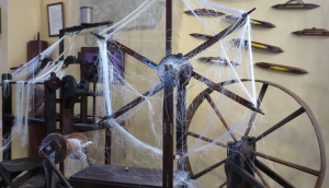
Loom in the Requena Silk Museum. / Image provided by Ester Alba
The main activity of the Valencian silk industry from the fifteenth to the end of the seventeenth century was the production of silk fiber, a job that was carried out intensively from March to June. “The production of silk fiber was a very intense activity carried out in a very specific season, but it was vital for the survival of peasant families”, explains Professor Ricardo Franch. It started by warming silkworm eggs through different methods, like using body heat or the warmth of the sun, but not before a ritual that involved bringing the silkworm eggs to the church to bless them. The enormous dedication required by this process was due to the fact that the income was obtained in June, coinciding with the payment of different leases. Thus, silk harvesting was essential to obtain the income needed to meet the economic demands of peasant families. When June arrived and the worms had already finished the cocoon, the silk was spun. This work, carried out mainly by women, was hard and left its mark on the hands of the peasants who pulled the thread after soaking it in hot water.
It's easy to visit La Lonja as it is centrally located in Valencia, close to other historic sites, such as the Central Market and Valencia Cathedral. The building is open for tours, and it's often less crowded than other famous sites in Spain, allowing a more relaxed visit. La Lonja de la Seda is a must-see for anyone visiting Valencia due to its stunning architecture, historical significance, and status as a UNESCO World Heritage site. It beautifully represents the peak of Valencia's commercial and cultural influence in the Middle Ages, making it a vital part of the city's heritage.
https://oceanposse.com/spain/