
EL SALVADOR
 Cruising the Pacific coast of El Salvador is a captivating experience that offers a blend of scenic beauty, cultural richness, and diverse marine life. However, it also presents certain challenges and dangers that sailors should be aware of. This guide will provide an in-depth look at what to expect when cruising this part of Central America, including the geographical highlights, local amenities, customs and entry procedures, and potential hazards.
Geographical Highlights
The Pacific coast of El Salvador stretches for approximately 320 kilometers and features a variety of landscapes, from sandy beaches and rocky cliffs to lush mangroves and serene bays. Key highlights along this route include:
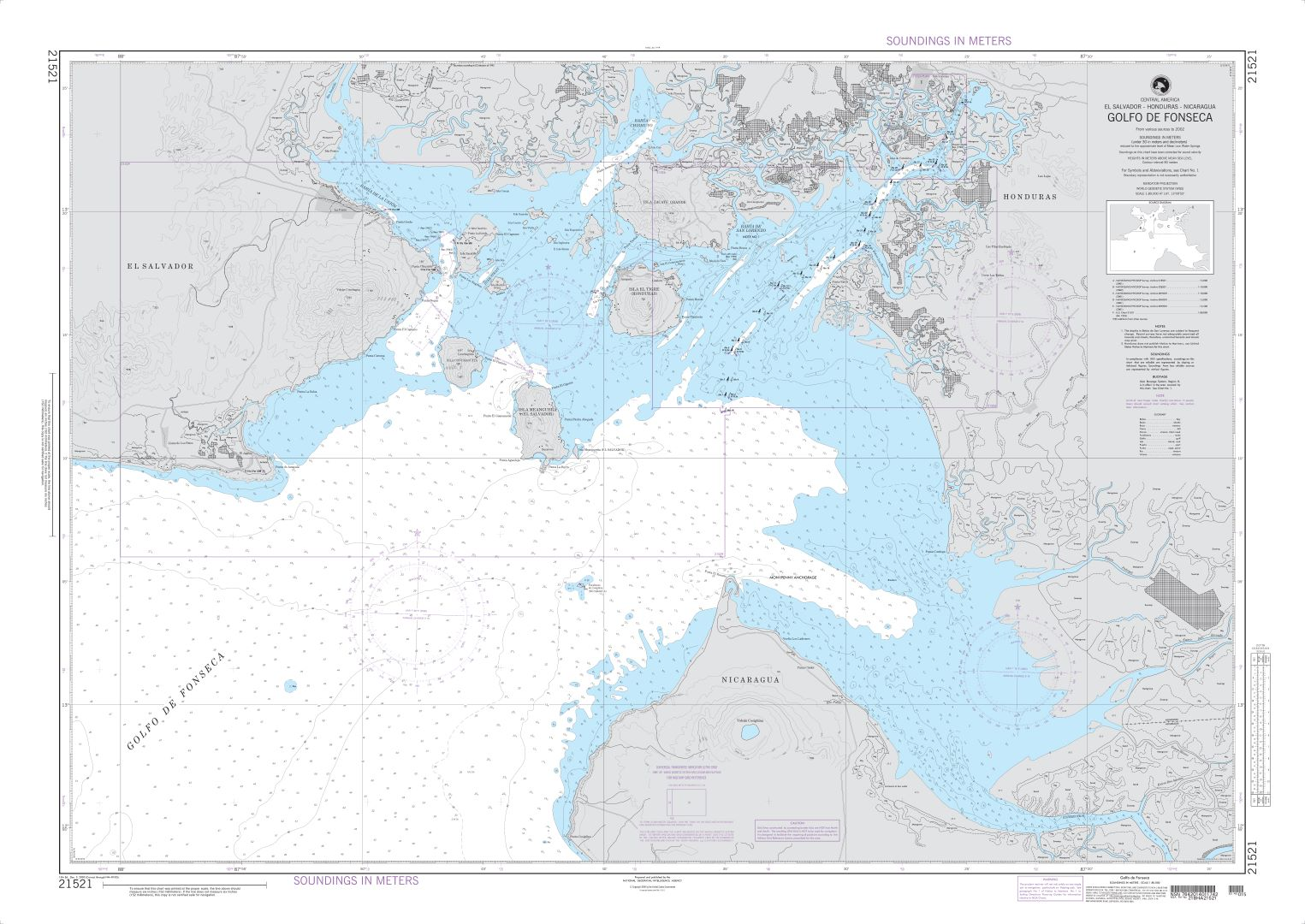
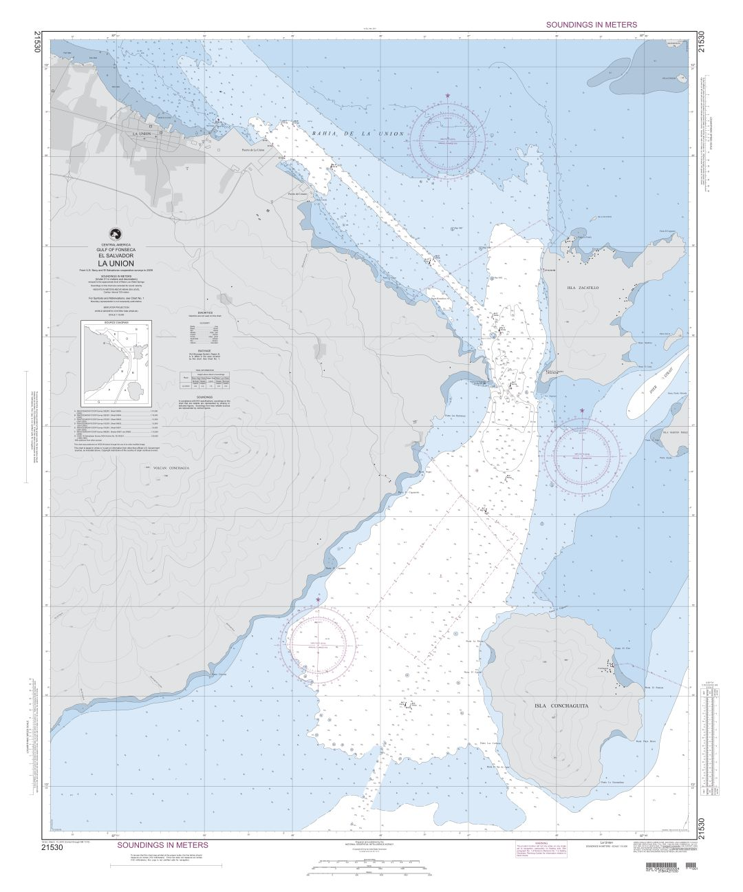
- Gulf of Fonseca: This large gulf is shared by El Salvador, Honduras, and Nicaragua. It offers numerous anchorages and is known for its rich biodiversity, including dolphins, turtles, and various bird species. The town of La Union serves as a significant port and entry point.
- Bahía de Jiquilisco: This bay is a UNESCO Biosphere Reserve and a crucial habitat for marine and bird life. The area is dotted with islands and channels, making it ideal for exploration by boat. The estuary provides safe anchorage and opportunities for eco-tourism.
- Playa El Cuco: A popular surfing destination with long sandy beaches and vibrant nightlife. Nearby, the estuary of San Diego offers a more tranquil setting for anchoring.
- Puerto Barillas: Located in the Jiquilisco Bay, Puerto Barillas is a marina and eco-lodge offering secure moorings, fuel, water, and provisions. It is a convenient stopover for cruisers looking for a secure and well-equipped marina.
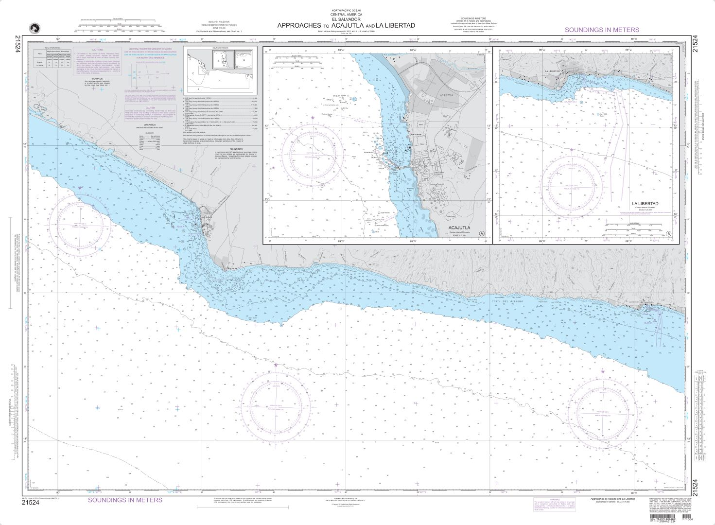
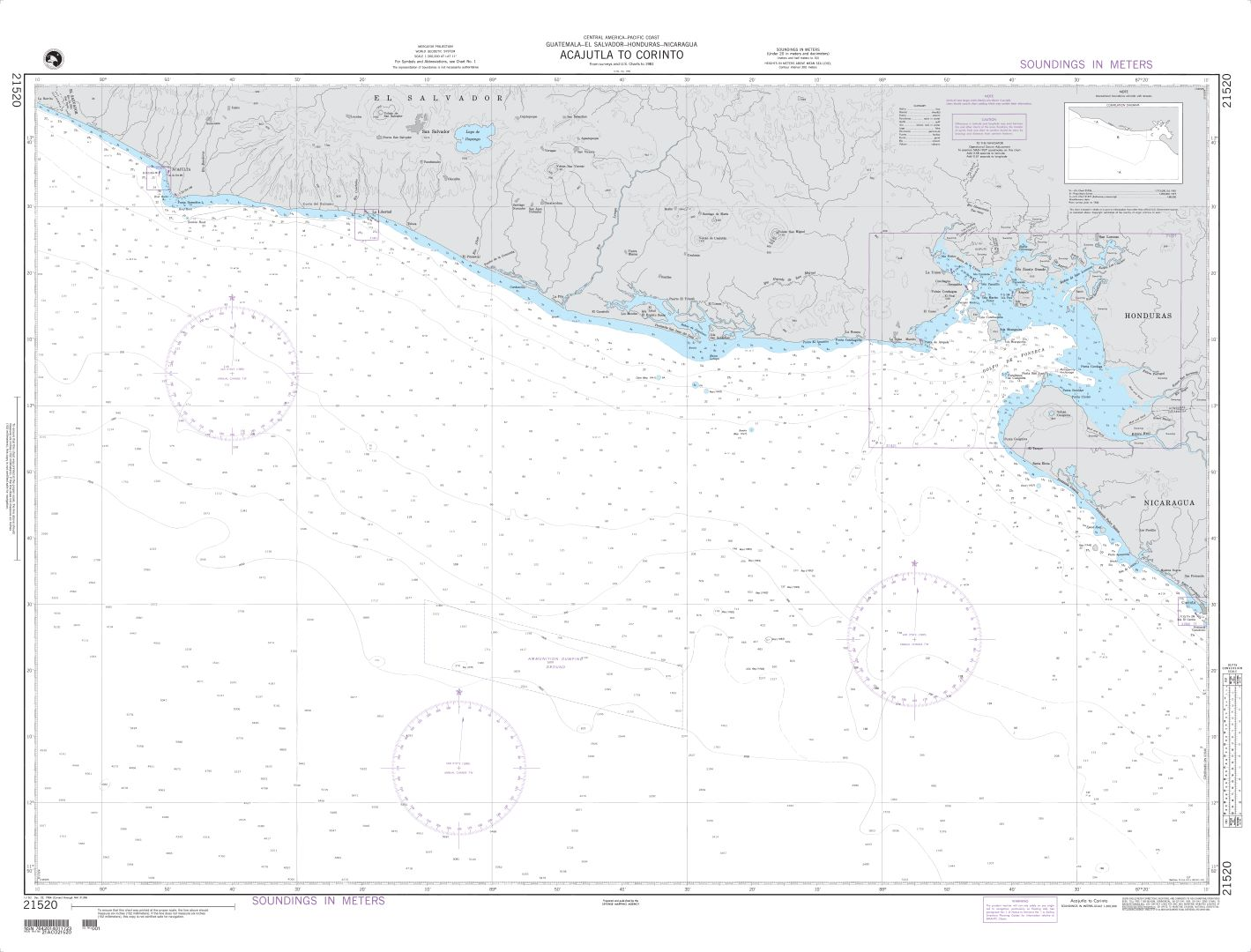
- Acajutla: The main commercial port of El Salvador. While it is primarily an industrial area, it provides necessary facilities for refueling and resupplying.
Local Amenities and Services
El Salvador’s Pacific coast, while not as developed as some other cruising destinations, offers essential amenities and services for sailors:
- Marinas and Anchorages: Apart from Puerto Barillas, other marinas and safe anchorages include La Union, Costa del Sol, and Bahia del Sol. These locations offer services such as fuel, water, provisions, and repair facilities.
- Provisioning: Major towns like La Union and Acajutla have supermarkets and local markets where cruisers can stock up on fresh produce, groceries, and other essentials.
- Communication: Internet and mobile phone coverage are generally good in coastal areas, with several providers offering prepaid SIM cards and data packages.
- Medical Facilities: Basic medical facilities are available in larger towns. For more specialized care, the capital, San Salvador, has well-equipped hospitals and clinics.
Customs and Entry Procedures
When cruising into El Salvador, it is essential to follow the correct entry procedures:
- Clearance: Sailors must clear into the country at an official port of entry, such as La Union or Acajutla. The process involves customs, immigration, and quarantine inspections. It is advisable to notify the authorities of your arrival in advance to ensure a smooth clearance process.
- Documentation: Required documents typically include passports, boat registration, crew list, and a list of onboard items. Ensure all paperwork is up-to-date and available for inspection.
- Fees: Entry and exit fees may apply, along with charges for port services. It is wise to carry cash in US dollars, the official currency of El Salvador, to pay any fees.
Navigational Challenges
Cruising the Pacific coast of El Salvador involves several navigational challenges:
- Tides and Currents: The coast experiences significant tidal variations and strong currents, particularly around river mouths and estuaries. Sailors should consult tide tables and local charts to plan their passages carefully.
- Weather: The region’s weather is generally tropical, with a distinct dry season (November to April) and rainy season (May to October). The rainy season can bring heavy rains, thunderstorms, and the potential for tropical storms or hurricanes. Regular weather updates and forecasts are essential for safe navigation.
- Coastal Features: The coast has numerous reefs, shoals, and rocky outcrops that can pose hazards to navigation. Detailed charts and local knowledge are invaluable for avoiding these dangers.
Potential Hazards
While cruising the Pacific coast of El Salvador is relatively safe, there are some potential hazards to be aware of:
- Crime: Although incidents involving cruisers are relatively rare, petty theft and robberies can occur. It is advisable to secure your vessel and valuables, avoid isolated areas, and be cautious when going ashore.
- Fishing Gear: Fishermen often set nets and longlines close to shore, which can be difficult to see and potentially entangle propellers. Keeping a vigilant watch and using AIS can help avoid these hazards.
- Weather Extremes: As mentioned, the rainy season can bring severe weather. Lightning storms are common, and sailors should be prepared to take appropriate precautions, such as disconnecting electronics and avoiding open water during storms.
- Marine Life: While generally not a threat, marine life such as jellyfish, stingrays, and certain fish species can pose risks if encountered. Awareness and caution while swimming or diving are advised.
- RIVER BAR & ESTUARY CROSSING: Several vessel shave been damaged entering and exiting the iver bar and estuary in and out of Bahia del Sol – Extra care when entering and only during extra high tides with low swells
Cultural and Environmental Considerations
El Salvador is rich in culture and natural beauty, and cruisers are encouraged to respect and preserve these aspects:
- Local Communities: Engage with local communities respectfully. Learning a few basic Spanish phrases can go a long way in fostering positive interactions.
- Environmental Protection: El Salvador’s coastal ecosystems are delicate. Avoid anchoring in coral reefs, dispose of waste properly, and participate in local conservation efforts where possible.
- Historical Sites: The country has a rich history, with archaeological sites, colonial architecture, and vibrant cultural festivals. Take the time to explore and appreciate these aspects of El Salvador.
MARINAS
WEATHER
SWELL
In El Salvador the Bar crossings need to be timed to low swell and calm conditions.
Watch for large Southern Ocean events which travel and make surfers happy but bar-crossings dangerous .WIND
TIDES
Pacific coast of Central America has semi-diurnal tides with a range of 6-9 feet / 2–3 m in El Salvador
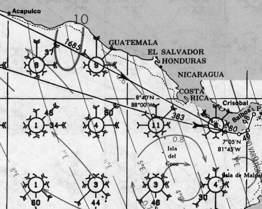
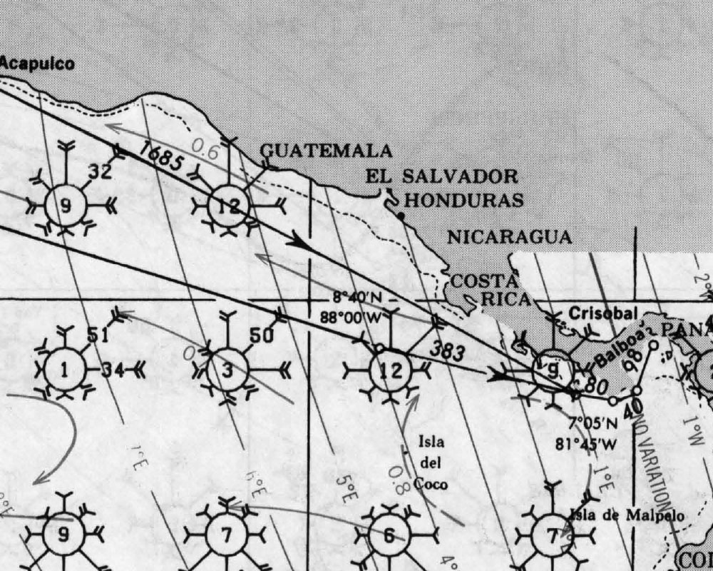
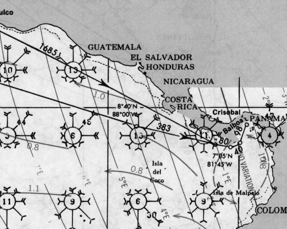
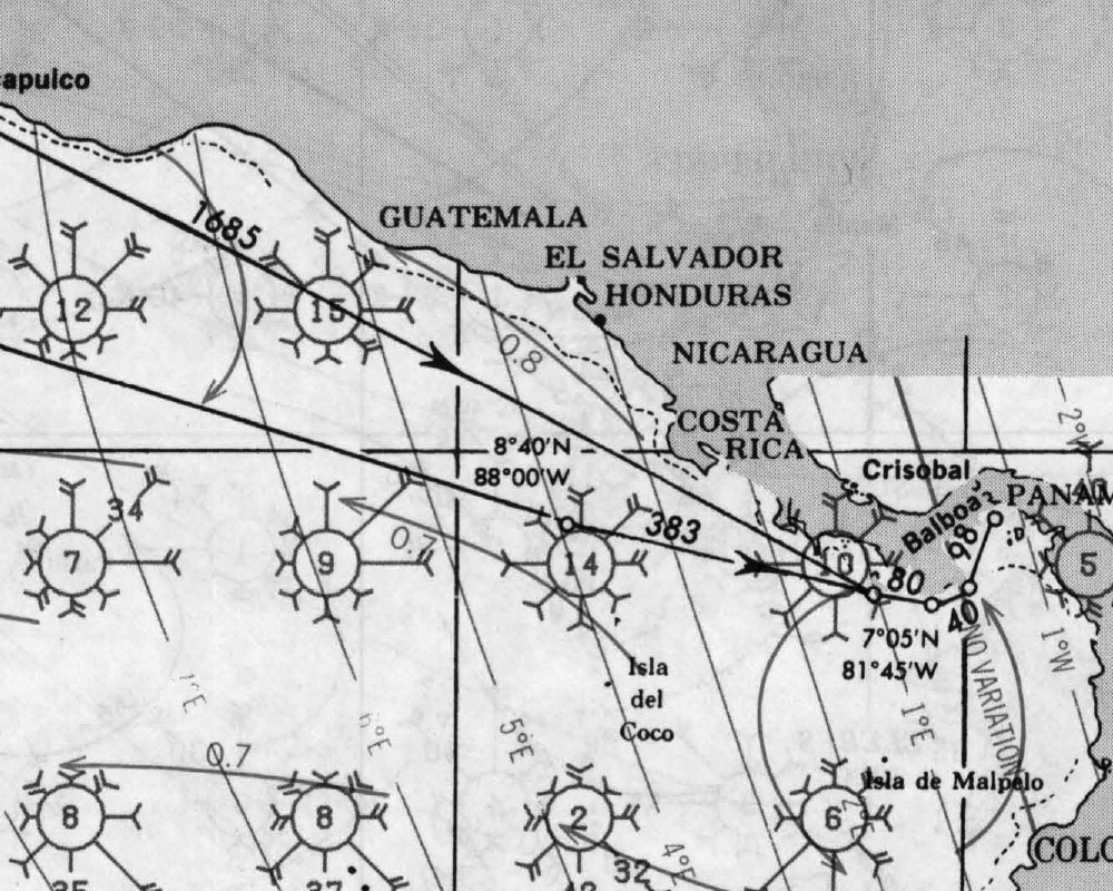
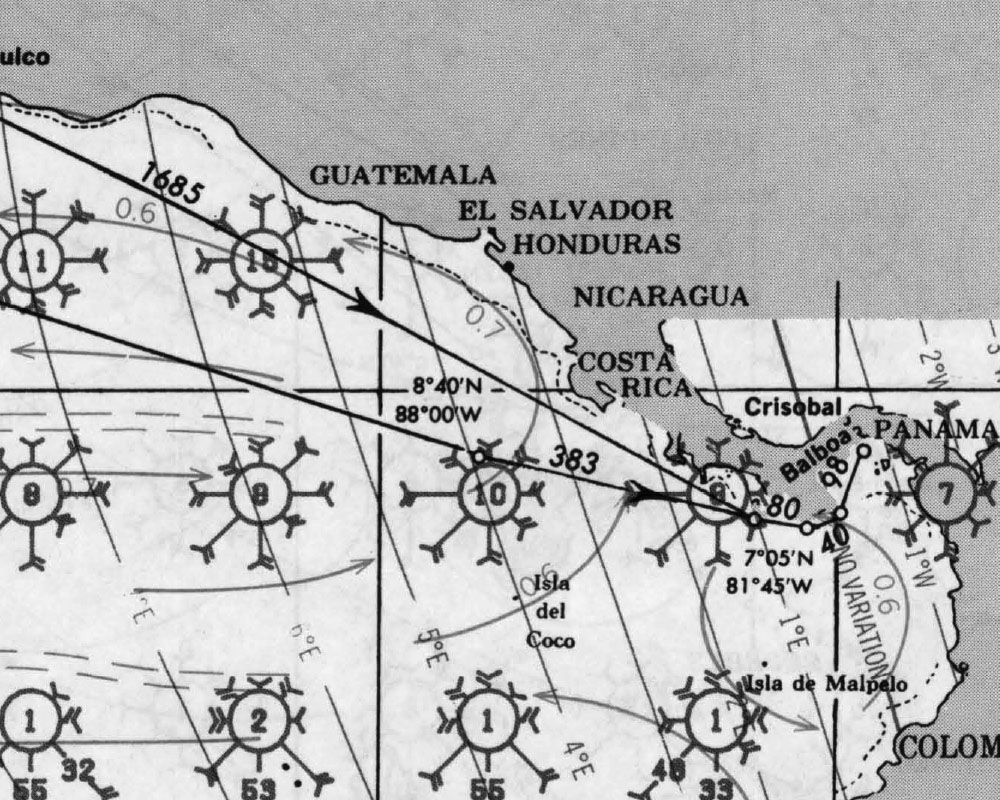
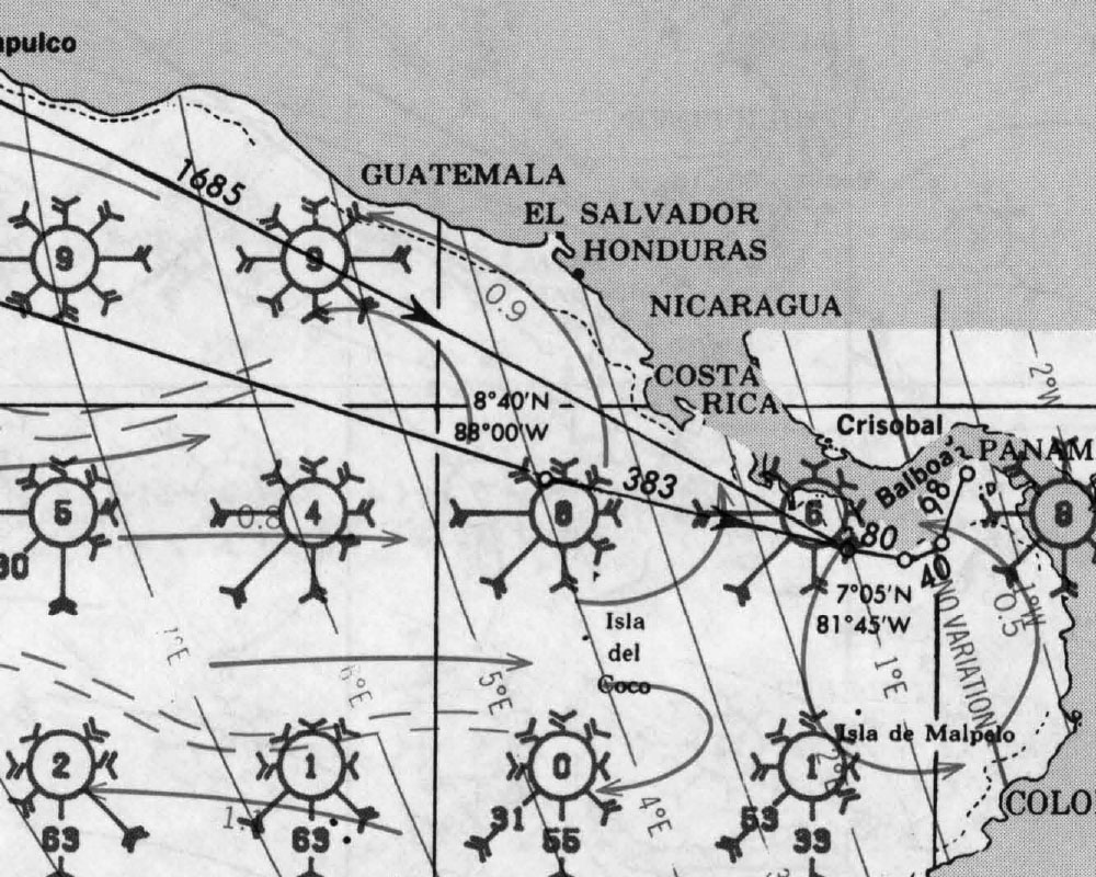
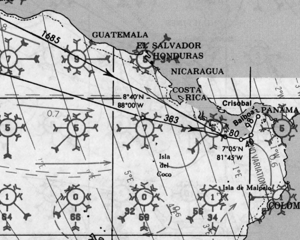
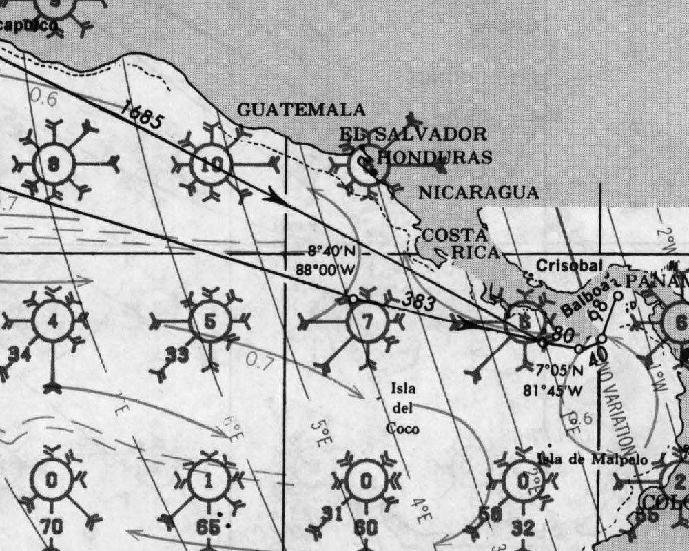
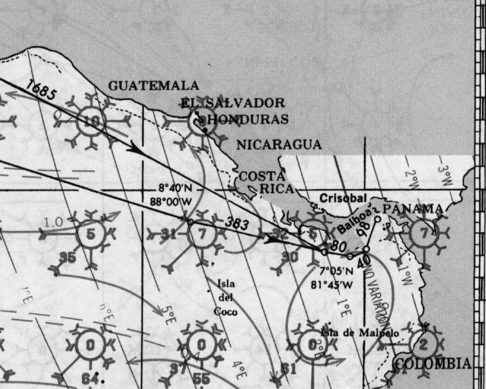
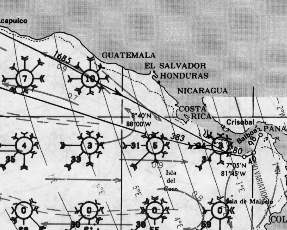
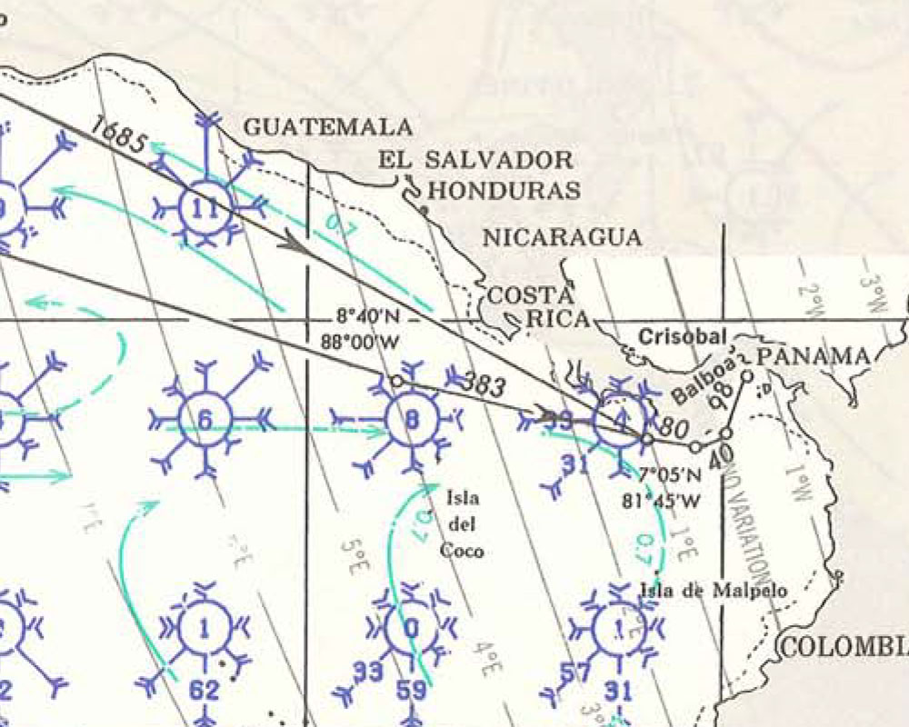
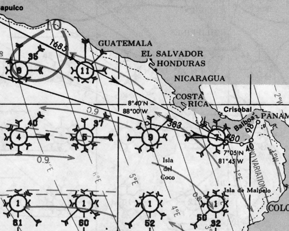
PILOT CHARTS
El Salvador Pilot Charts depict averages in prevailing winds and currents, air and sea temperatures, wave heights, visibility, barometric pressure, and weather conditions at different times of the year. The information used to compile these averages was obtained from oceanographic and meteorologic observations over many decades during the late 18th and 19th centuries. The charts aid the navigator in selecting the fastest and safest routes with regards to the expected weather and ocean conditions. In El Salvador the Bar crossings need to be timed to low swell and calm conditions. Details on El Salvador Climatology and how to read Wind-roses follow this link.
PORTS OF ENTRY
Port of entry via Marina Bahia del Sol or
- La Unión – Latitude: 13° 19.20′ N, Longitude: 87° 50.70′ W
- Acajutla – Latitude: 13° 34.40′ N, Longitude: 89° 49.20′ W
- Puerto El Triunfo (Usulután) – Latitude: 13° 17.50′ N, Longitude: 88° 30.50′ W
These ports provide facilities for customs, immigration, and quarantine, making them key entry points for maritime travelers to El Salvador.
DOCUMENTS
| DOCUMENTATION | EL SALVADOR |
| Passport | Valid for length of stay |
| Boat Documentation | Coast Guard Doc (Original) |
| Proof of Insurance | Liability Insurance may be required by marinas |
| Crewlist | Required at checkin/out |
| Zarpe | Required at checkin/out |
| OFFICIAL PROCEDURES | |
| Official Country Visa | None if stay is less than 90 days |
| Immigration Visa | Good for 90 days with one 30-day extension; CA-4 Tourist Card ($10) available if travelling via land between Guatemala, El Salvador, Nicaragua, Honduras |
| Required Permits | Temporary Importation Permit (fee $1/day); cruising permit (valid for 2 months) |
| Upon Arrival Visit: | Immigration; Custom; Port Authority; Port Captain |
| Upon Departure Visit: | Immigration; Port Captain |
| Entry & Exit Fees: | Free to $50 |
| Notes: | Visas obtained in El Salvador are issued for 90 days and are good for four Central American countries, El Salvador, Guatemala, Nicaragua, and Honduras but only for those traveling by land. If you take your boat to one of the other countries you will have to get a new visa and a Zarpe. Tourists who wish to remain in the four-country region beyond their initial 90-day visa can obtain a one-time in-country (not required to leave) 90-day extension by applying at Migration in San Salvador and paying $25. You will be required to show reason why you cannot leave the country (hurricane season, illnesses. etc) and have a resident or company sign an affidavit to “sponsor” you. Forms are available on-line and you will need two photos. When that visa expires, you are required to leave the four-country area, the nearest being Mexico, Belize, or Costa Rica. Many cruisers schedule their inland travel to include travel briefly outside the four-country region to renew their visas just prior to the expiration date.Port fees are $1 per day to use Salvadorian waters. The fee is payable in 30-day increments up to 90 days. After 90 days you must renew your permit at the port offices (AMP) located on the hotel grounds. The permit has unlimited renewals. If you leave your boat unattended over 90 days you can pay for your permit when you return. |
| OTHER | |
| Required Vaccinations | None |
| Pets | Vaccinations Certificate |
| Currency: | US Dollar |
COUNTRY CONTACT – EL SALVADOR RALLY
US EMBASSYTEL 2501 2999Final Blvd. Santa Elena
Antiguo Cuseatlan, La LibertadSan Salvador
 Information for U.S. Citizens and Lawful Permanent Residents | U.S. Embassy in El Salvador
Country-Specific Information: El Salvador has confirmed cases of COVID-19 within its borders. The Government of El Salvador created a platform for sharing COVID-19 information: covid19.gob.sv Entry and Exit Requirements: On March 11, the government of El Salvador prohibited foreigners from entering…  El Salvador International Travel Information
El Salvador international travel information and Travel Advisory
MUST SEE
Must-See Places in El Salvador, Including UNESCO World Heritage Sites
El Salvador, the smallest country in Central America, is a land of stunning natural beauty, rich history, and vibrant culture. Despite its size, it boasts a diverse array of must-see places that cater to all kinds of travelers, from lush national parks and pristine beaches to archaeological wonders and charming colonial towns. Here’s an in-depth look at some of the top destinations in El Salvador, including its UNESCO World Heritage Sites.
1. Joya de Cerén Archaeological Site
- Location: La Libertad Department
- Coordinates: 13.8075° N, 89.3695° W
Joya de Cerén is often referred to as the “Pompeii of the Americas” because it offers a rare glimpse into the daily life of a pre-Columbian farming community. This UNESCO World Heritage Site was buried under volcanic ash from the eruption of the Loma Caldera around 600 AD, which preserved the village remarkably well. Excavations have revealed thatched houses, communal buildings, and even the remains of crops, providing invaluable insights into the lives of the Maya people.
2. San Salvador
- Location: San Salvador Department
- Coordinates: 13.6929° N, 89.2182° W
The capital city, San Salvador, is a bustling metropolis that combines modernity with historical charm. Key attractions include the Metropolitan Cathedral, the National Palace, and the Plaza Barrios. The city is also home to several museums, such as the Museo de Arte de El Salvador (MARTE) and the Museo Nacional de Antropología Dr. David J. Guzmán, which offer deep dives into the country’s artistic and anthropological history.
3. Suchitoto
- Location: Cuscatlán Department
- Coordinates: 13.9383° N, 89.0262° W
Suchitoto is a picturesque colonial town known for its cobblestone streets, well-preserved architecture, and vibrant cultural scene. Highlights include the Santa Lucia Church, built in the 19th century, and the various art galleries and craft shops that line the streets. The town overlooks Lake Suchitlán, offering beautiful views and opportunities for boat tours, fishing, and bird watching.
4. Santa Ana Volcano (Ilamatepec)
- Location: Santa Ana Department
- Coordinates: 13.8532° N, 89.6303° W
Santa Ana Volcano, also known as Ilamatepec, is the highest volcano in El Salvador and a popular hiking destination. The trek to the summit is challenging but rewarding, offering panoramic views of the surrounding landscapes, including Coatepeque Lake and other volcanic formations. At the top, hikers can peer into the crater, which contains a striking green sulfur lake.
5. Tazumal
- Location: Chalchuapa, Santa Ana Department
- Coordinates: 13.9736° N, 89.6742° W
Tazumal is one of the most important and well-preserved pre-Columbian archaeological sites in El Salvador. The site features a complex of pyramids, palaces, and ball courts that date back to the Maya civilization. The main pyramid, which stands at around 24 meters high, is particularly impressive. The on-site museum provides additional context and displays artifacts found during excavations.
6. Ruta de las Flores
- Location: Sonsonate and Ahuachapán Departments
- Coordinates: Starting point in Sonsonate: 13.7148° N, 89.7255° W
The Ruta de las Flores (Route of the Flowers) is a scenic drive that winds through the highlands, connecting a series of charming towns known for their coffee plantations, colorful murals, and vibrant festivals. Key stops along the route include Nahuizalco, Juayúa, Apaneca, Ataco, and Ahuachapán. Each town has its unique attractions, from Juayúa’s famous food festival to Apaneca’s adventure sports.
7. El Imposible National Park
- Location: Ahuachapán Department
- Coordinates: 13.8333° N, 89.8833° W
El Imposible National Park is one of El Salvador’s most important natural reserves, protecting a variety of ecosystems and an array of wildlife. The park offers numerous hiking trails that range from easy to challenging, leading visitors through dense forests, along rivers, and to breathtaking viewpoints. It’s a haven for bird watchers, with over 400 species recorded in the area.
8. Los Cóbanos
- Location: Sonsonate Department
- Coordinates: 13.5258° N, 89.7980° W
Los Cóbanos is a coastal area known for its extensive coral reef, which is the largest in the Pacific waters of Central America. It’s a prime spot for snorkeling and diving, offering the chance to see a wide variety of marine life, including colorful fish, sea turtles, and rays. The nearby village provides basic amenities and a laid-back atmosphere.
9. Perquín
- Location: Morazán Department
- Coordinates: 13.9333° N, 88.1167° W
Perquín is a small town with a significant place in El Salvador’s modern history. It was a stronghold for the FMLN guerrillas during the Civil War. Today, the Museo de la Revolución provides a detailed account of the conflict, with exhibits that include photographs, weapons, and personal accounts. The town also offers beautiful mountain scenery and hiking opportunities.
10. Cerro Verde National Park
- Location: Santa Ana Department
- Coordinates: 13.8350° N, 89.6275° W
Cerro Verde National Park is a lush, green park that provides access to three major volcanoes: Izalco, Santa Ana (Ilamatepec), and Cerro Verde. The park offers well-maintained trails, picnic areas, and lookout points with stunning views of the volcanic landscape and Coatepeque Lake. Guided tours are available for those who wish to learn more about the area’s geology and ecology.
11. Coatepeque Lake
- Location: Santa Ana Department
- Coordinates: 13.9038° N, 89.5450° W
Coatepeque Lake is a beautiful crater lake surrounded by mountains and volcanic peaks. It’s a popular spot for swimming, kayaking, and sailing. The lake’s clear blue waters and the surrounding scenery make it one of the most picturesque locations in El Salvador. Several restaurants and hotels around the lake offer delicious local cuisine and comfortable accommodations.
12. San Andrés Archaeological Site
- Location: La Libertad Department
- Coordinates: 13.8000° N, 89.3900° W
San Andrés is another significant Maya archaeological site, featuring a large ceremonial center, pyramids, and residential areas. The site also has a museum that displays artifacts and provides insights into the life and culture of the Maya people who inhabited the area. San Andrés is part of the larger Zapotitán Valley, which was an important agricultural region in pre-Columbian times.
Conclusion
El Salvador offers a rich tapestry of experiences for travelers, from exploring ancient Maya ruins and colonial towns to hiking volcanic landscapes and enjoying pristine beaches. The country’s UNESCO World Heritage Sites, such as Joya de Cerén, provide fascinating glimpses into its past, while its natural parks and scenic routes showcase its stunning natural beauty. Whether you’re an adventurer, a history buff, or a culture enthusiast, El Salvador’s diverse attractions are sure to leave a lasting impression.
REPAIRS AND SERVICE PROVIDERS
LOGIN TO DOWNLOAD THE LATEST SAFE GPX TRACK IN AND OUT OF THE ESTUARY
,
CHARTS
DOWNLOAD EL SALVADOR PLANNING CHARTS
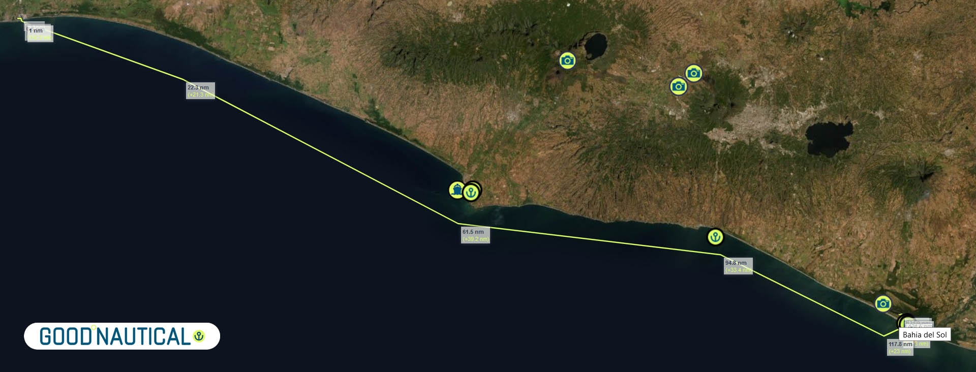
🇬🇹 PUERTO QUETZAL - BAHIA DEL SOL 🇸🇻 125 nm
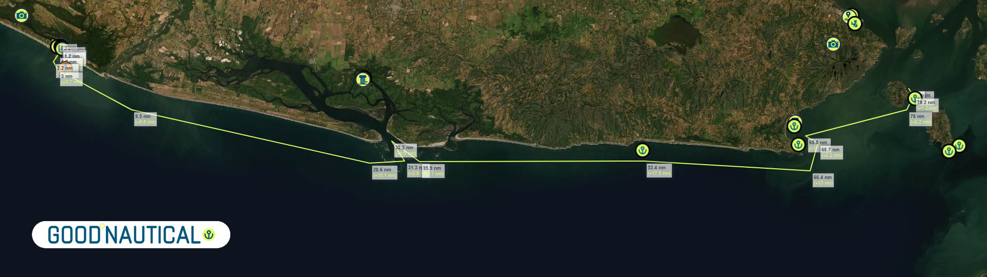
🇸🇻 BAHIA DEL SOL - GOLFO DE FONSECA - 🇸🇻 🇭🇳 🇳🇮 80 nm
DOWNLOAD EL SALVADOR PLANNING CHARTS
🇬🇹 PUERTO QUETZAL - BAHIA DEL SOL 🇸🇻 125 nm
🇸🇻 BAHIA DEL SOL - GOLFO DE FONSECA - 🇸🇻 🇭🇳 🇳🇮 80 nm
COMMUNICATIONS
http://diariolatino.net/ >>
 Google Translate
From:
ENGLISH LANGUAGE LOCAL NEWSPAPERS AND NEWS SOURCES