

🇳🇿 NEW ZEALAND 🏝 2 +70
 Cruising and Sailing New Zealand North Island:
New Zealand’s North Island offers a wealth of diverse cruising opportunities for yachtsmen, blending dramatic coastlines, vibrant marine life, and welcoming communities. From the subtropical waters of the Bay of Islands to the rugged, wind-swept shores of Taranaki, the North Island is a true sailor’s paradise. This guide provides an overview of key destinations, anchorages, local facilities, and must-see attractions for anyone planning a voyage in these waters.
1. Bay of Islands: Subtropical Splendor
The Bay of Islands is often the first port of call for international yachts arriving in New Zealand, and for good reason. This subtropical haven boasts over 140 islands, secluded anchorages, and historical sites.
- Anchoring Highlights – there ar over 100 bays and spots to discover and many are breathtaking.
- Opua: The primary customs clearance port with excellent marina facilities.
- Russell: Known as the “Hellhole of the Pacific” in its whaling days, now a quaint town with good moorings.
- Urupukapuka Island: Offers safe anchorage and hiking trails with panoramic views.
- What to Do:
- Visit the Waitangi Treaty Grounds to learn about New Zealand’s founding history.
- Explore the underwater world at the Poor Knights Islands, considered one of the world’s best dive sites.
2. Auckland: The City of Sails
Auckland, often dubbed the “City of Sails,” is the yachting hub of New Zealand. With over one-third of its residents owning a boat, the city thrives on its maritime culture.
- Marinas and Anchorages:
- Westhaven Marina: One of the largest marinas in the Southern Hemisphere.
- Viaduct Harbour: Ideal for luxury yachts and a gateway to Auckland’s vibrant dining scene.
- Exploring the Gulf:
- The Hauraki Gulf Marine Park encompasses a myriad of islands like Waiheke, known for its vineyards, and Rangitoto, with its volcanic cone.
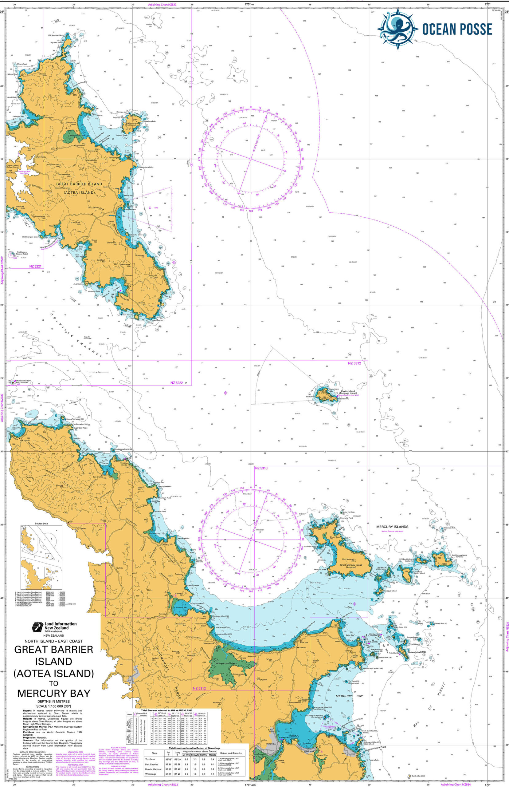
- Sailing to Great Barrier Island (Aotea) offers a unique adventure, blending stunning natural beauty with rich cultural experiences. Located approximately 90 kilometers northeast of Auckland, the island is accessible by sea, making it a favored destination for sailors seeking both challenge and tranquility.Approach and Navigation:
- Routes: Departing from Auckland, sailors typically navigate through the Hauraki Gulf, passing landmarks such as Rangitoto Island and the Coromandel Peninsula. The journey covers about 50 nautical miles, depending on the chosen route.
- Conditions: The Hauraki Gulf is known for variable weather patterns. It’s essential to monitor forecasts closely and plan for potential changes in wind and sea conditions.
Anchorages and Moorings:
- Port Fitzroy: Located on the western side, this harbor provides sheltered anchorage with facilities like fuel and provisions.
- Whangaparapara Harbour: Another well-protected spot, offering moorings and access to local amenities.
- Tryphena Harbour: Situated on the southern coast, it’s a convenient entry point with anchorage options and nearby services.
Facilities and Services:
- Marinas: While Great Barrier Island doesn’t have large-scale marinas, several harbors offer mooring facilities. It’s advisable to contact local operators in advance to secure a spot.
- Supplies: Basic provisions are available in settlements like Claris and Tryphena. However, stocking up before departure is recommended due to limited supplies on the island.
Activities and Attractions:
- Hiking: The island boasts numerous trails, including the Aotea Track, offering panoramic views and encounters with native flora and fauna.
- Hot Springs: Natural hot springs near Whangaparapara provide a relaxing retreat after a day of sailing.
3. Coromandel Peninsula: Rugged Beauty
The Coromandel Peninsula offers a mix of dramatic cliffs, hidden coves, and lush native forests. It’s a slightly more remote cruising destination but worth every nautical mile.
- Key Stops:
- Whitianga Harbour: A well-protected anchorage with easy access to hot springs and local markets.
- Cathedral Cove: Accessible by tender, this iconic rock arch is a must-see.
- Activities:
- Snorkeling in Gemstone Bay.
- Digging your own thermal pool at Hot Water Beach.
4. Bay of Plenty: Rich Waters
As the name suggests, the Bay of Plenty offers abundant marine resources and opportunities for exploration. It’s a favored stop for yachts heading southward.
- Marinas:
- Tauranga Bridge Marina: Provides full-service facilities and easy access to the city.
- Whakatane: A smaller but welcoming port for those venturing toward White Island.
- Unique Experiences:
- Explore White Island (Whakaari), New Zealand’s most active volcano.
- Taste the region’s world-famous kiwifruit.
5. East Cape: Untouched Wilderness
The East Cape is one of the most remote and untouched parts of New Zealand, offering an off-the-beaten-path experience for adventurous sailors.
- Anchorages:
- Hicks Bay: A calm and sheltered stopover.
- Tolaga Bay: Home to the longest wharf in the Southern Hemisphere.
- Local Culture:
- Experience Māori culture firsthand in the small coastal settlements.
- Visit the East Cape Lighthouse for stunning views of the Pacific.
6. Wellington: The Capital’s Call
Nestled at the southern tip of the North Island, Wellington is both the cultural and political heart of New Zealand. The city’s harbor is a natural amphitheater, offering safe moorings and a vibrant waterfront.
- Marinas:
- Chaffers Marina: Located in the heart of the city, it provides easy access to Wellington’s attractions.
- Seaview Marina: A quieter option with excellent facilities.
- Things to See:
- The Te Papa Museum, showcasing New Zealand’s natural and cultural history.
- Cable Car rides offering views of the city and beyond.
7. Navigational Notes and Weather Considerations
New Zealand’s North Island is known for its variable weather patterns, influenced by the Roaring Forties and the surrounding ocean. Here are some key considerations:
- Seasons:
- Summer (December to February) is ideal for cruising, offering warm weather and calm seas.
- Winter months can bring stronger winds and cooler temperatures but fewer crowds.
- Prevailing Winds:
- Northerly winds dominate in summer, while westerly and southerly systems are common in winter.
- Hazards:
- Keep an eye out for submerged rocks and shifting sandbanks, especially near river mouths.
- Tides can be strong, particularly in the Cook Strait and other narrow passages.
8. Maritime Services and Provisions
New Zealand’s North Island is well-equipped to support cruising yachts:
- Chandleries and Repairs:
- Auckland and Tauranga are major hubs for marine services.
- Smaller ports like Opua also cater to international yachts with comprehensive repair facilities.
- Customs and Biosecurity:
- New Zealand has strict biosecurity regulations. All yachts must declare food, plants, and animals on arrival.
- Fuel and Water:
- Most marinas provide refueling and potable water facilities. Plan ahead in remote areas like the East Cape.
9. Local Etiquette and Conservation
New Zealanders (Kiwis) are renowned for their hospitality and love of the outdoors. While cruising, keep these principles in mind:
- Respect Māori Traditions:
- Many anchorages have cultural significance to the Māori people. Seek permission when in doubt and respect local customs.
- Environmental Stewardship:
- Adhere to the “Clean Below? Good to Go!” campaign to prevent the spread of invasive marine species.
- Follow marine reserves’ rules, which often prohibit fishing and anchoring.
MARINAS
WEATHER
-41.24206 173.16673
WIND
SWELL
SEVERE WEATHER
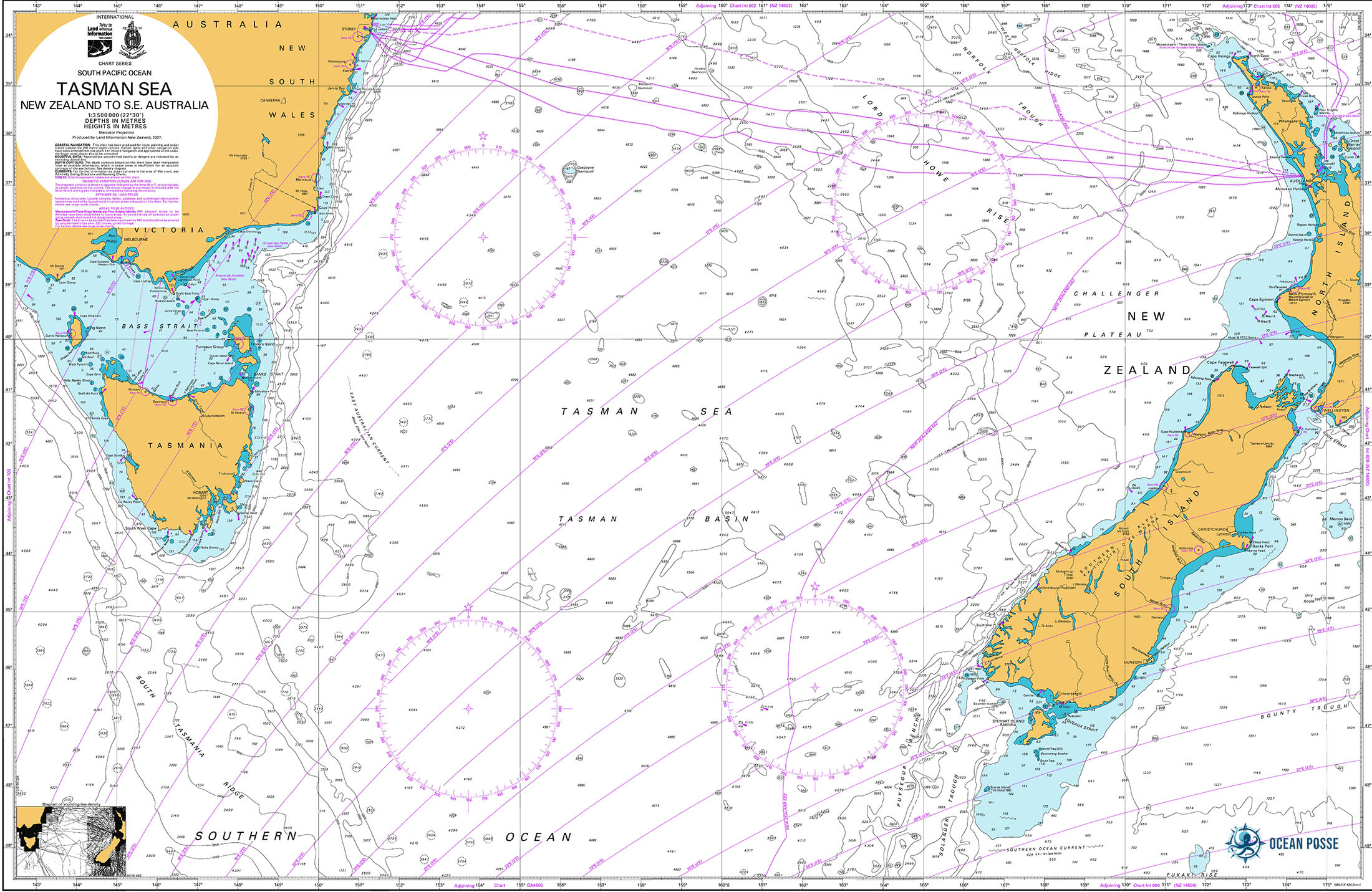
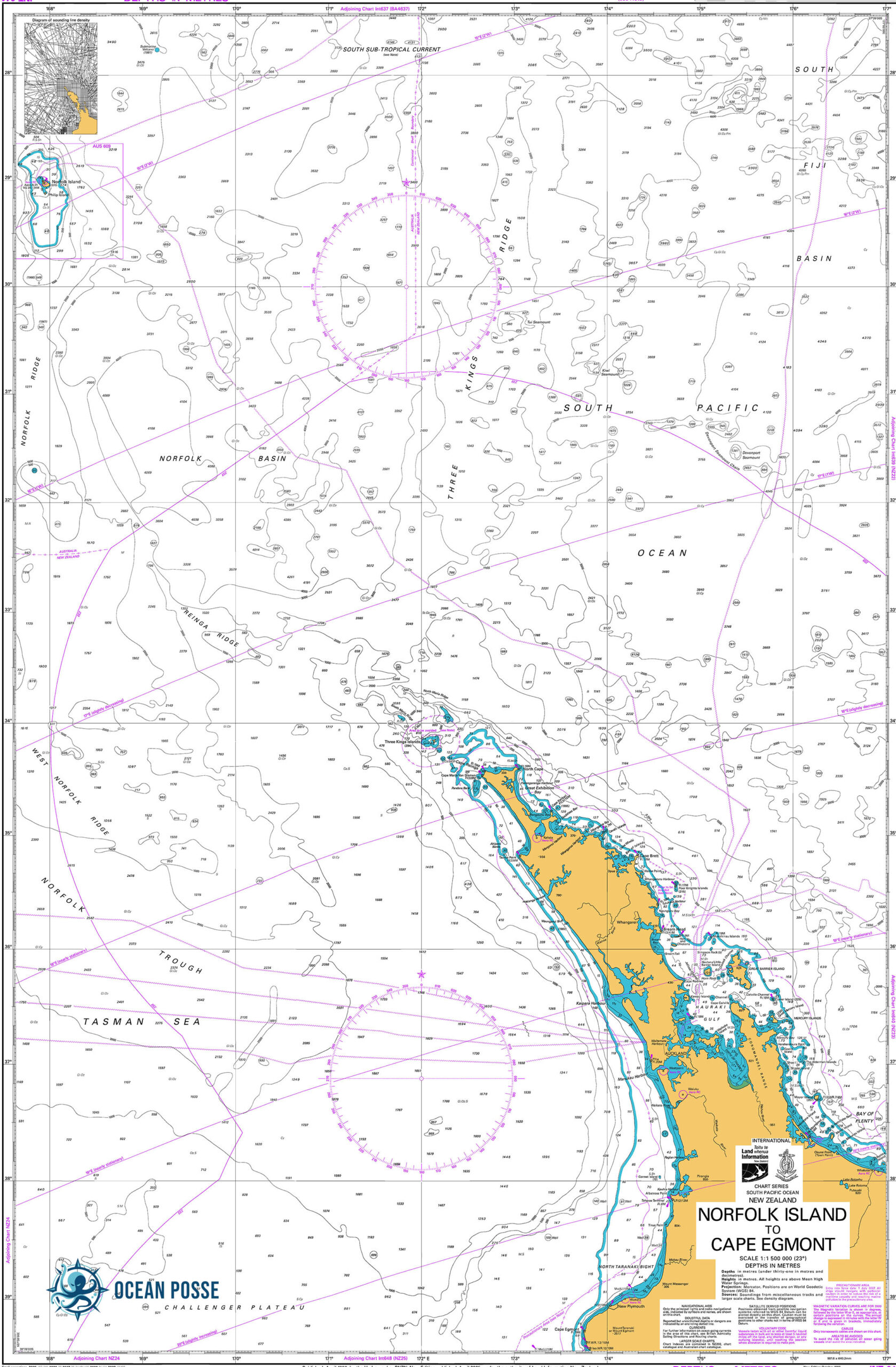
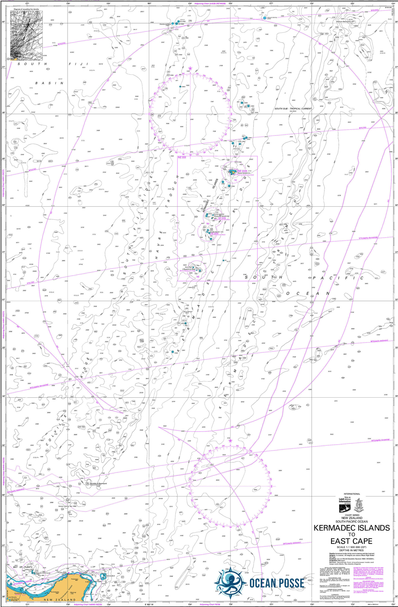
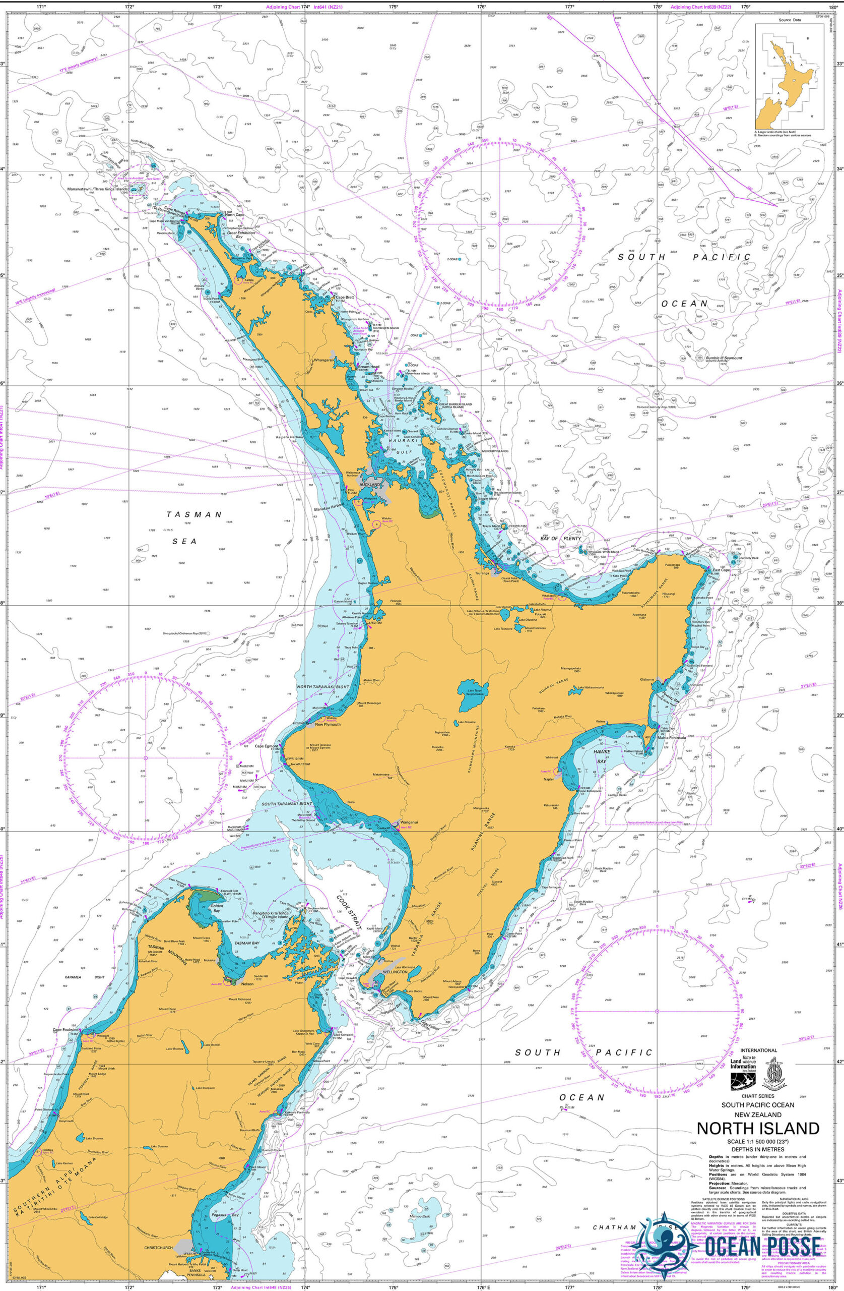
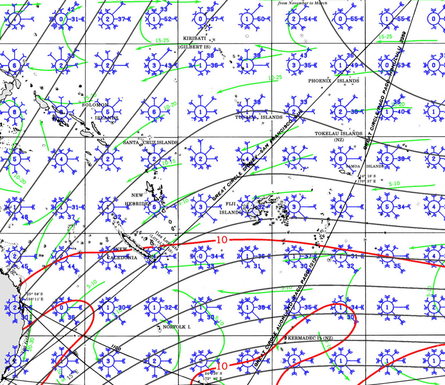
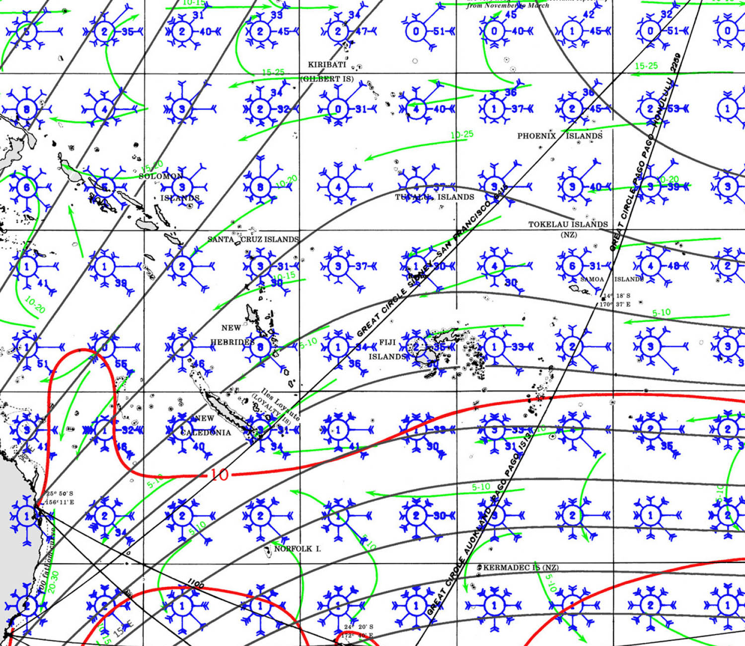
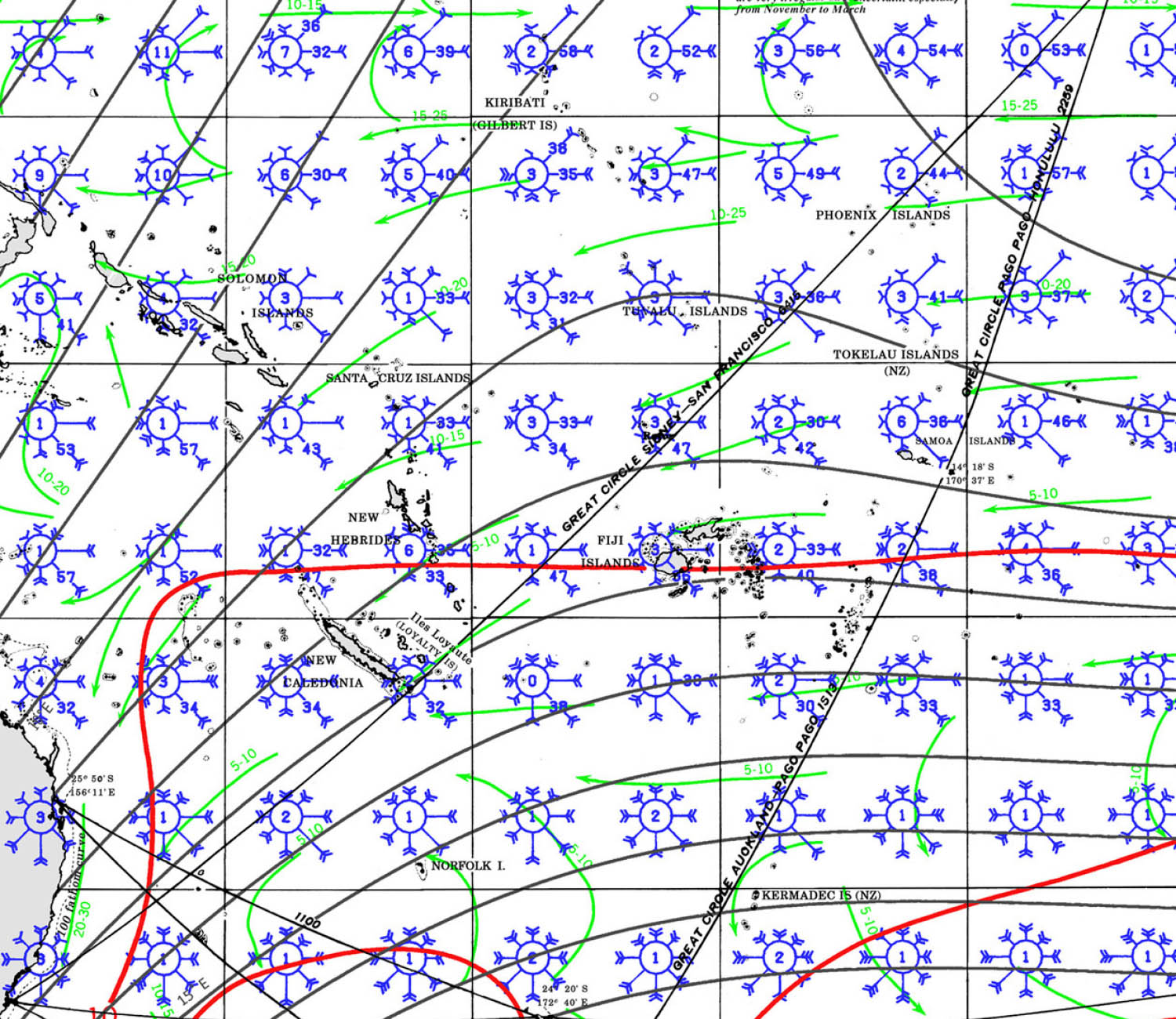
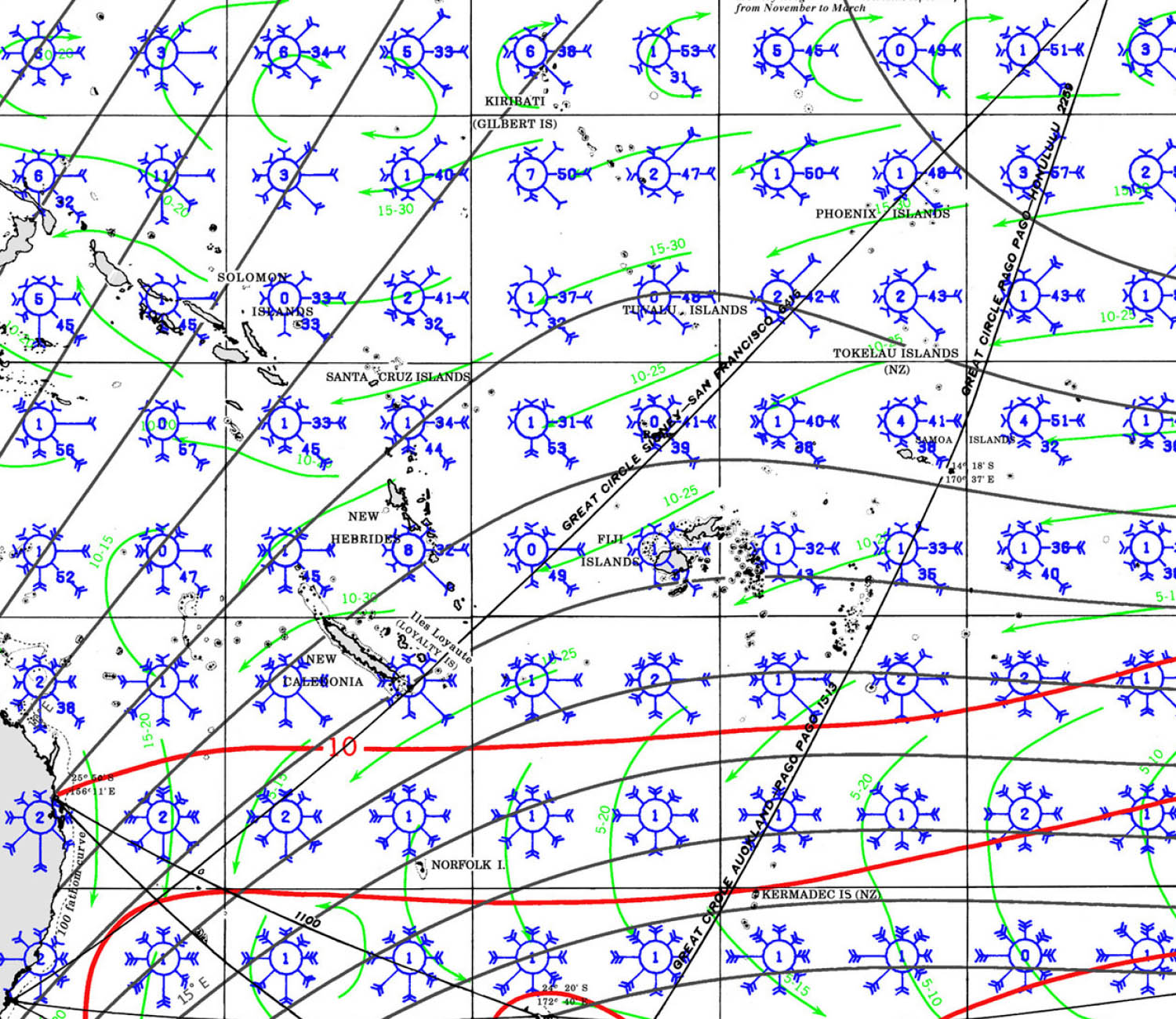
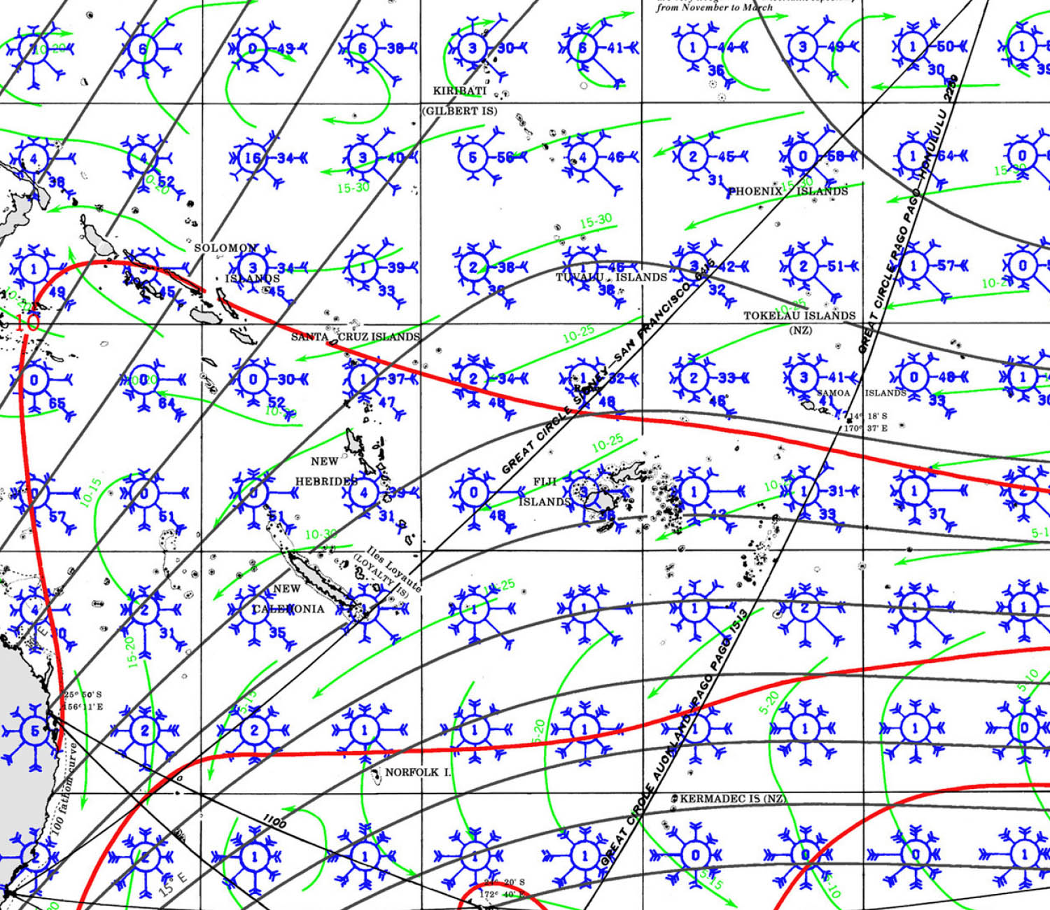
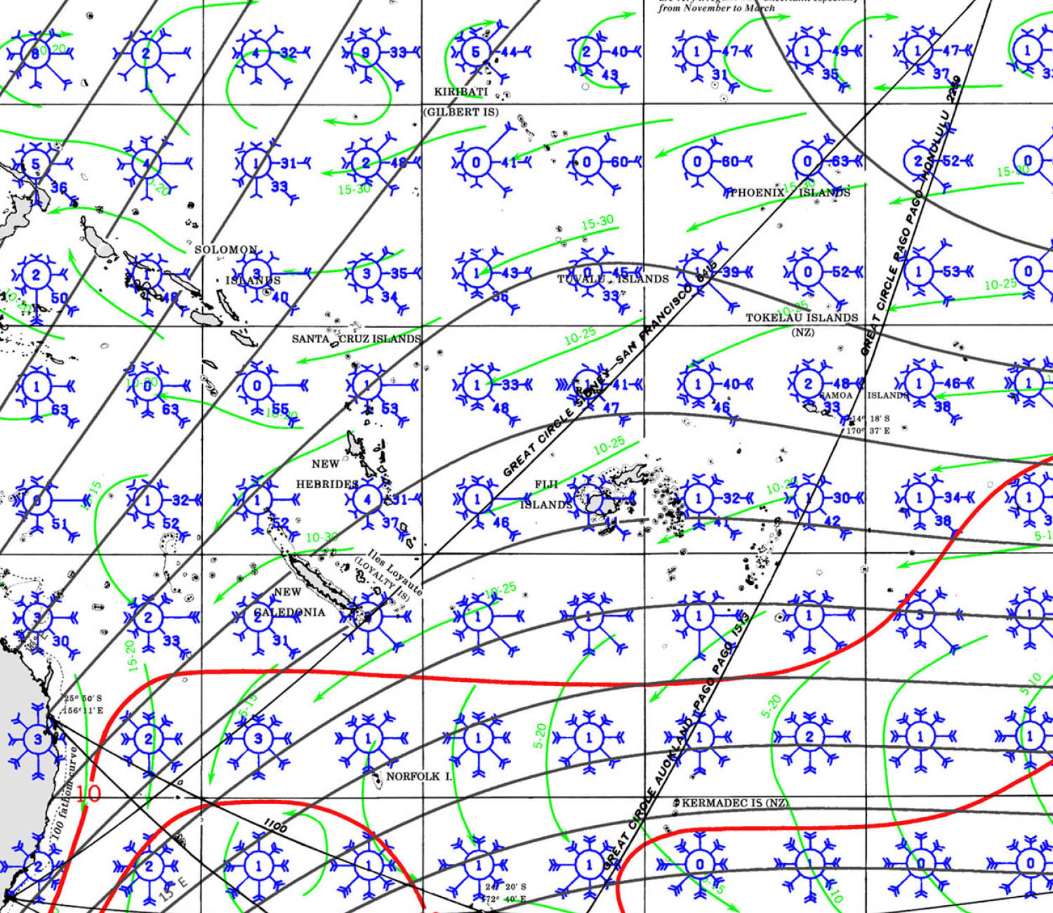
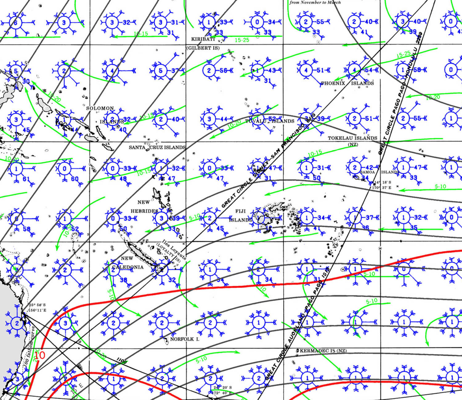
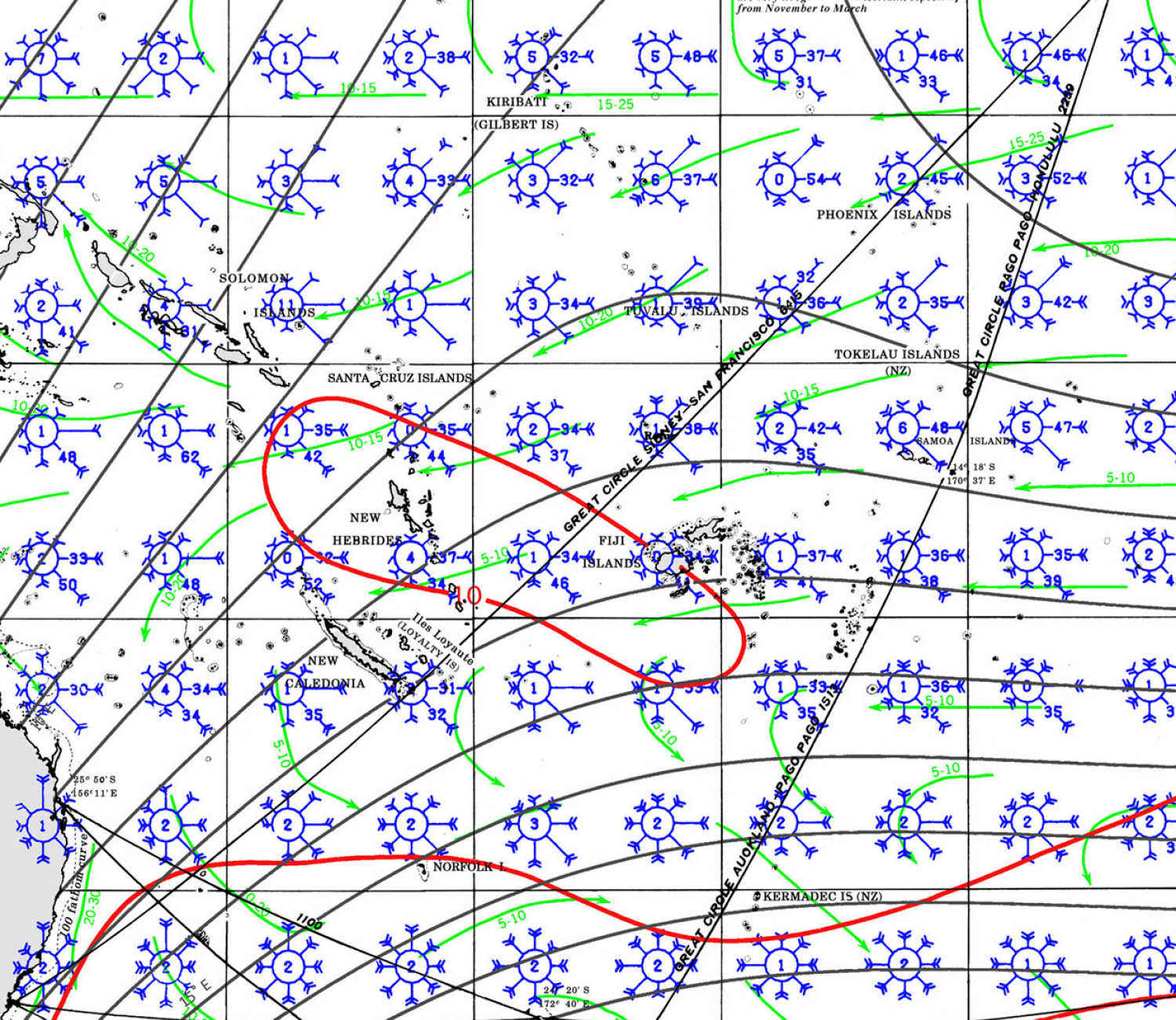
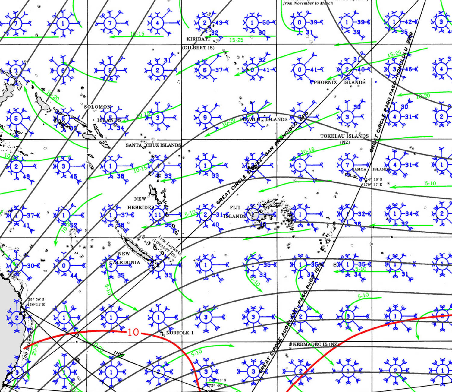
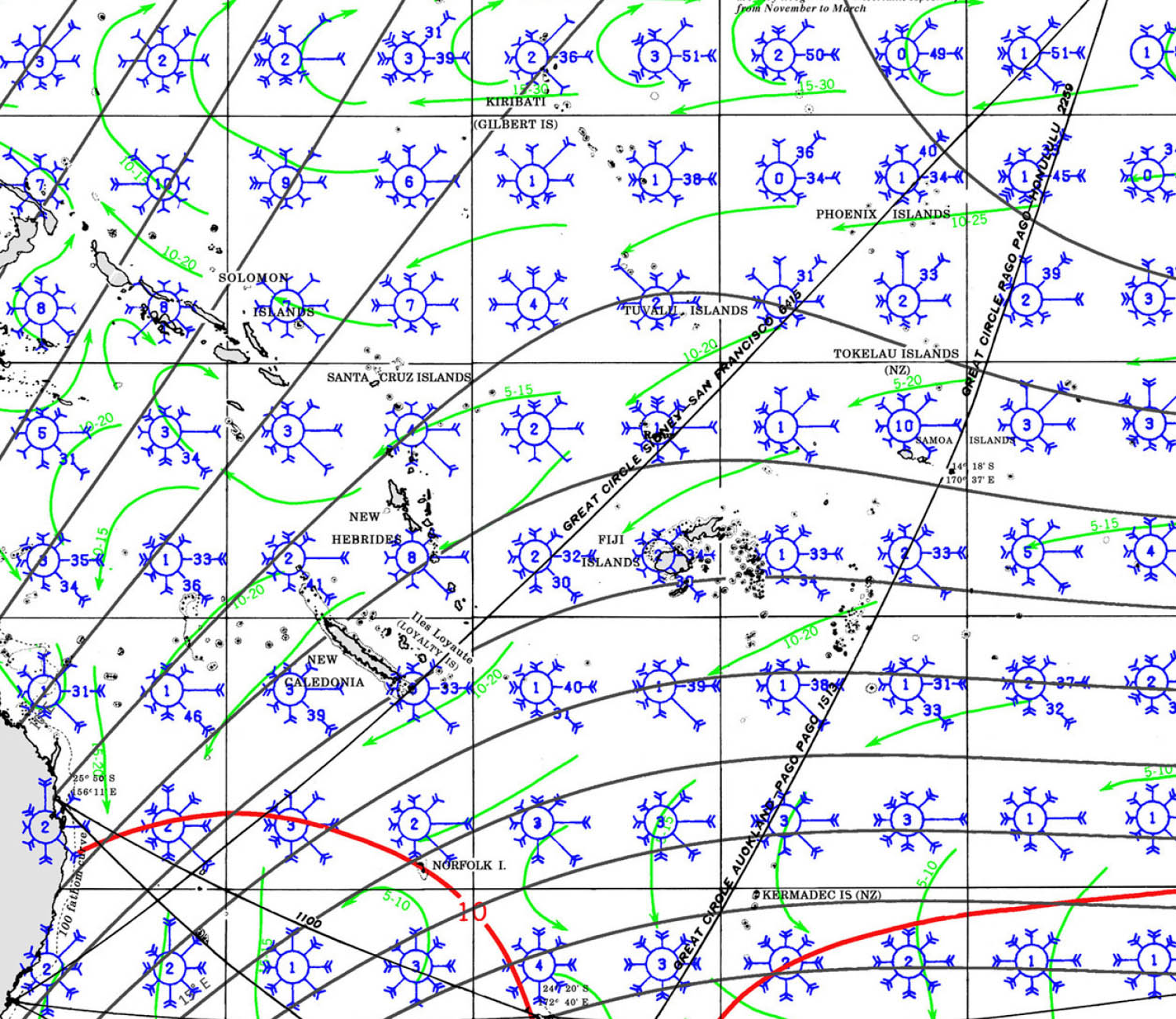
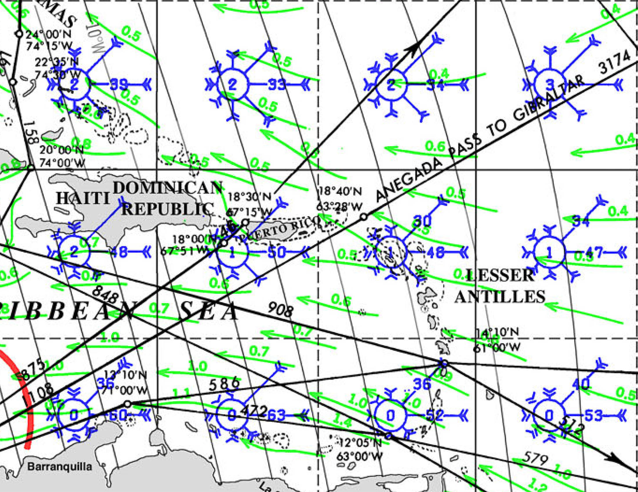
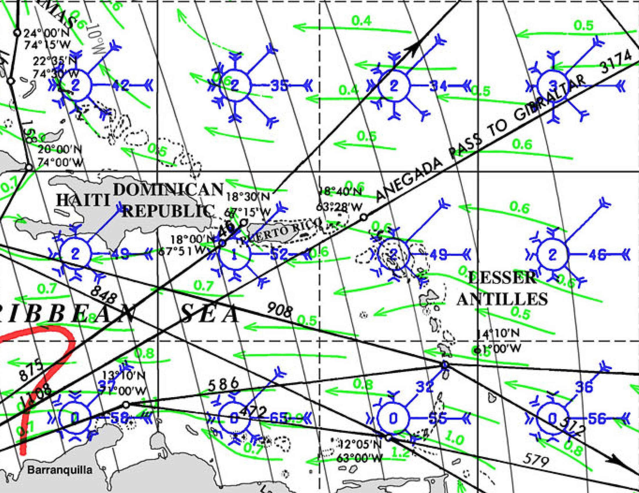
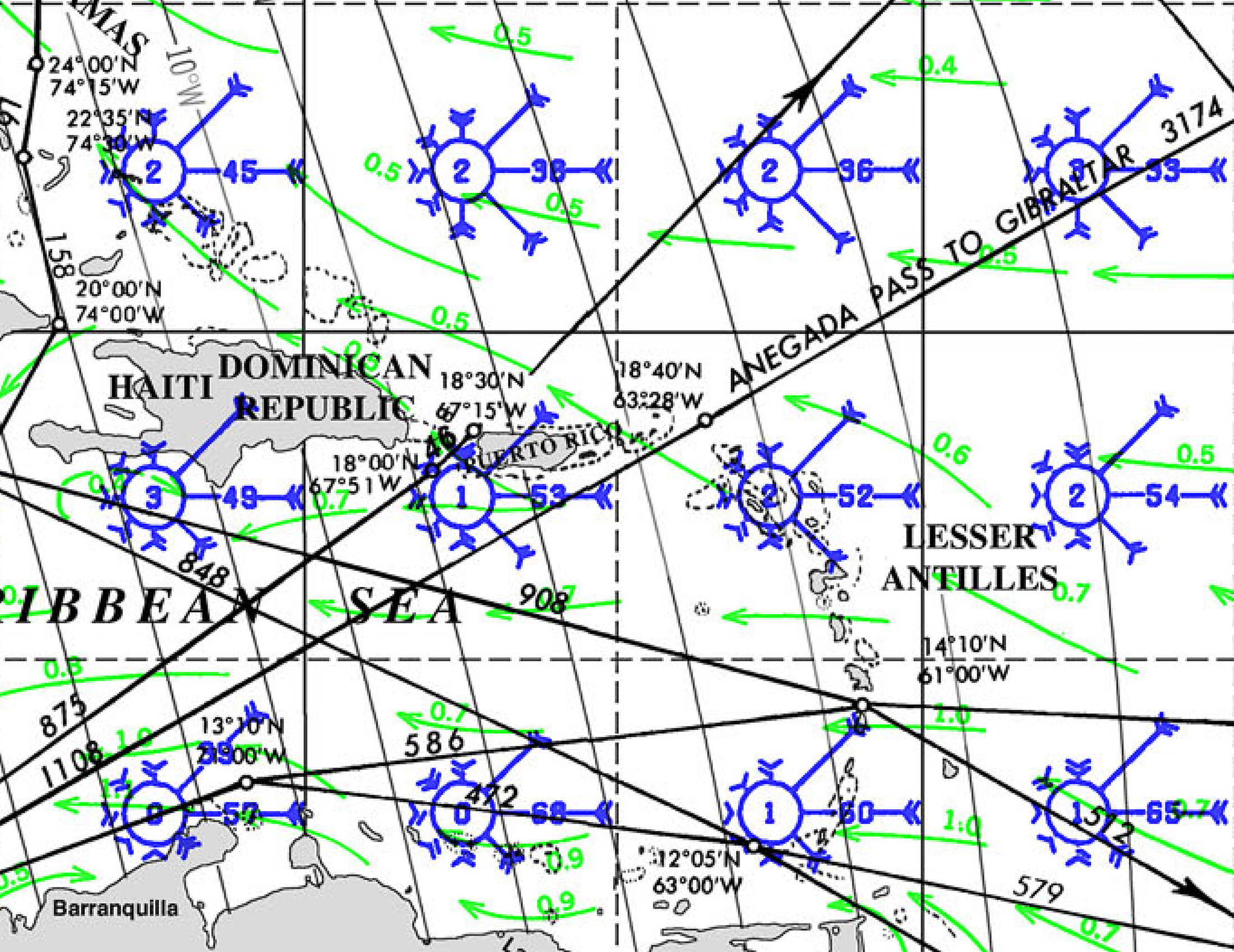
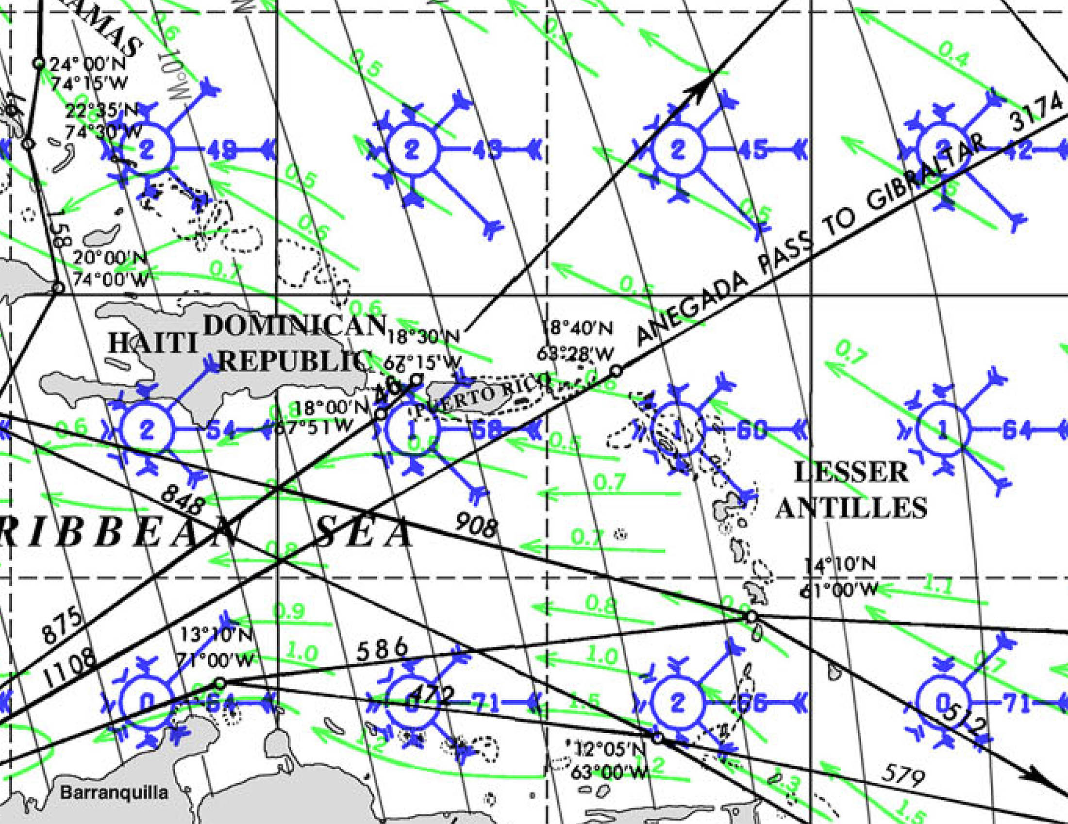
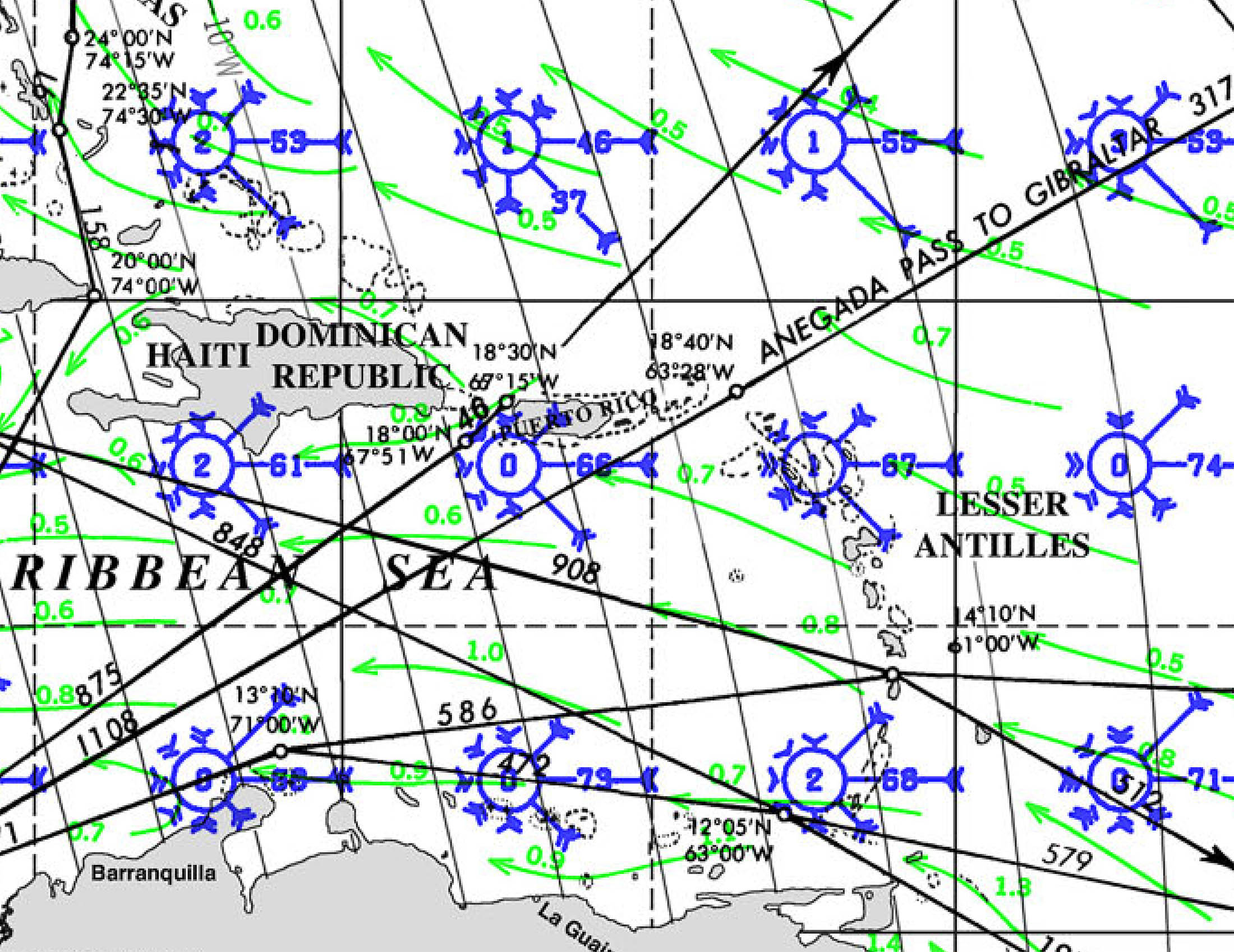
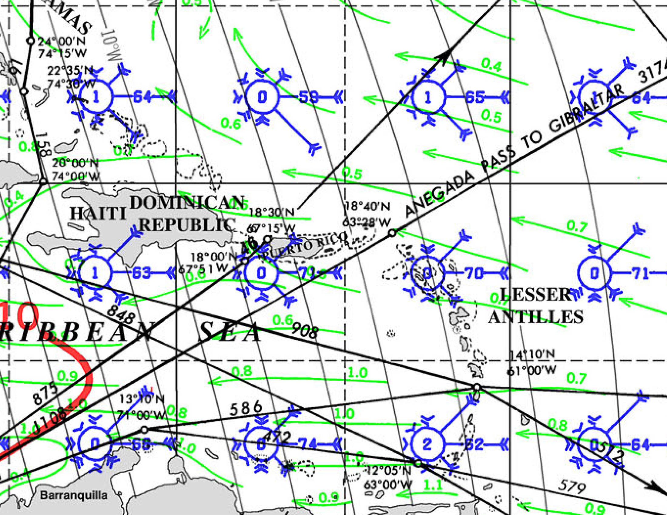
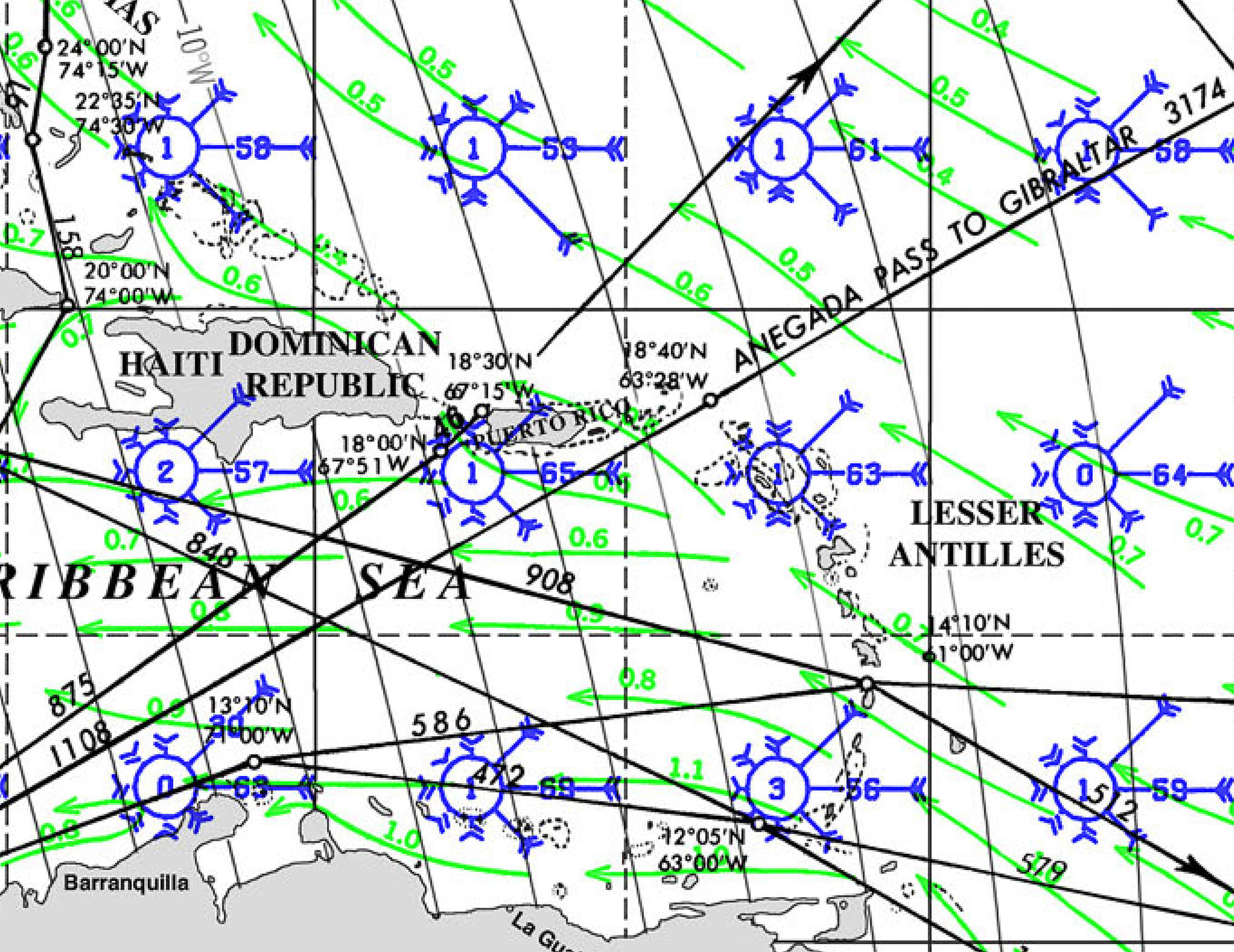
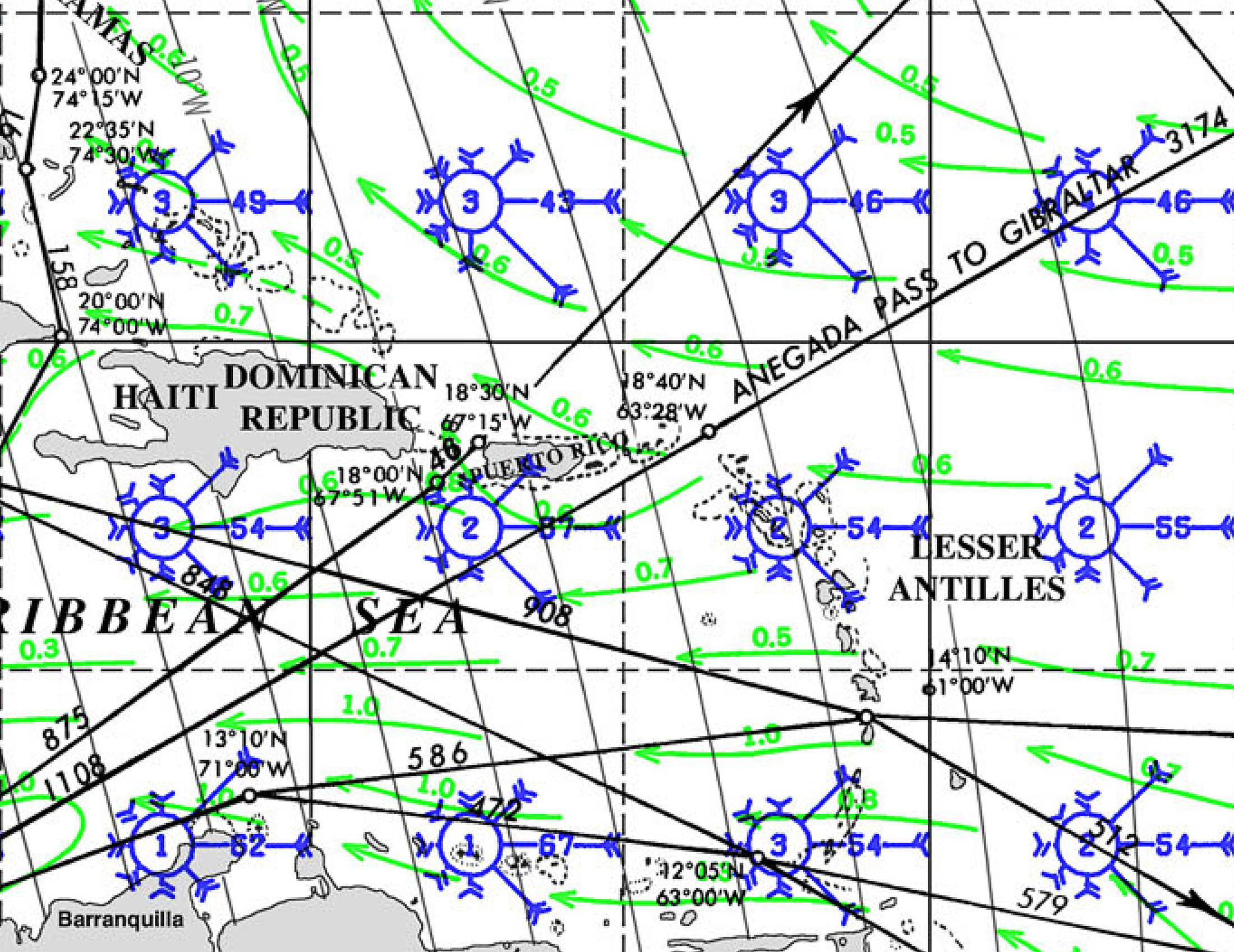
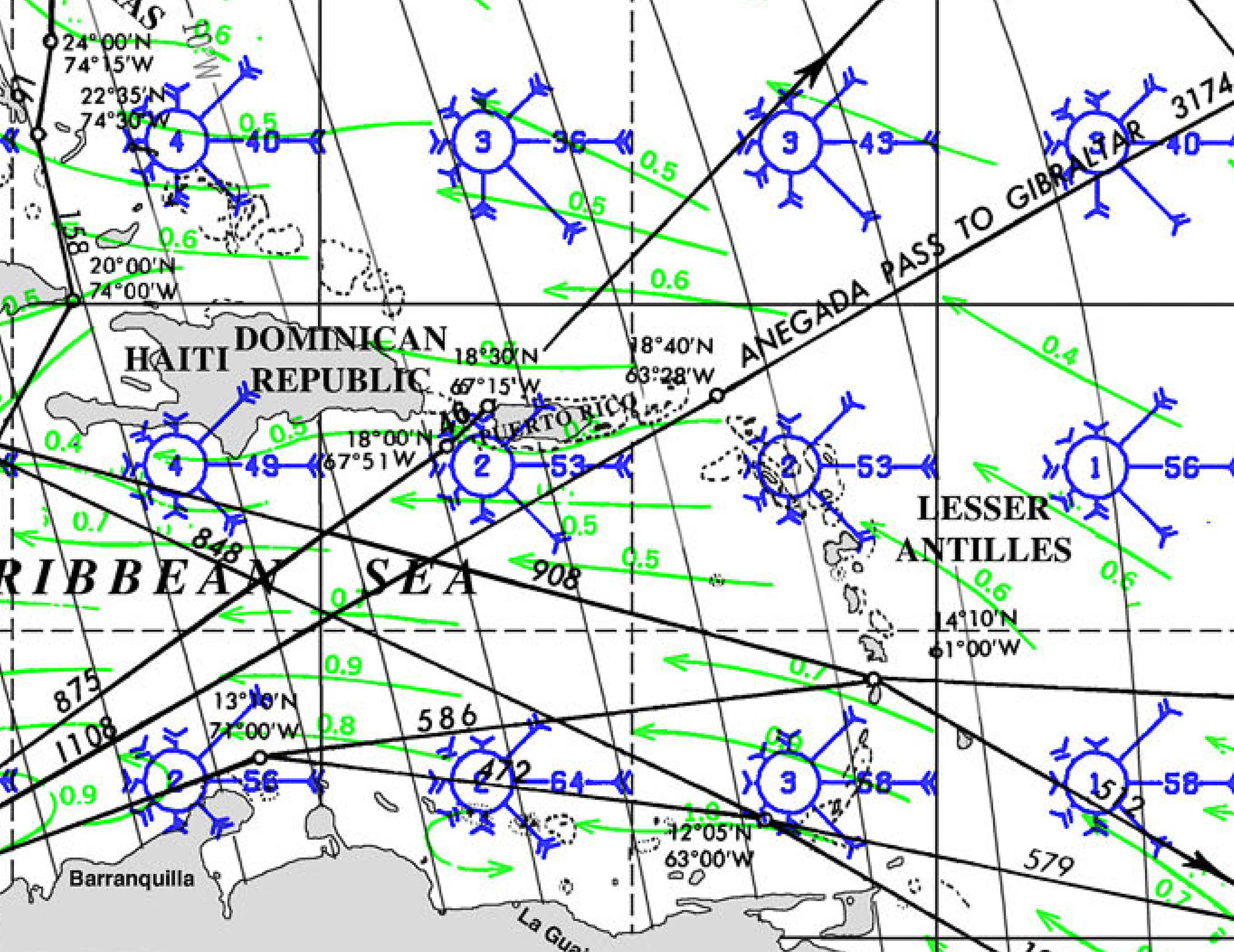
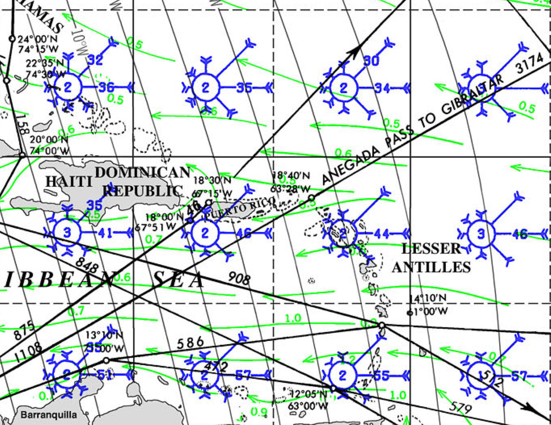
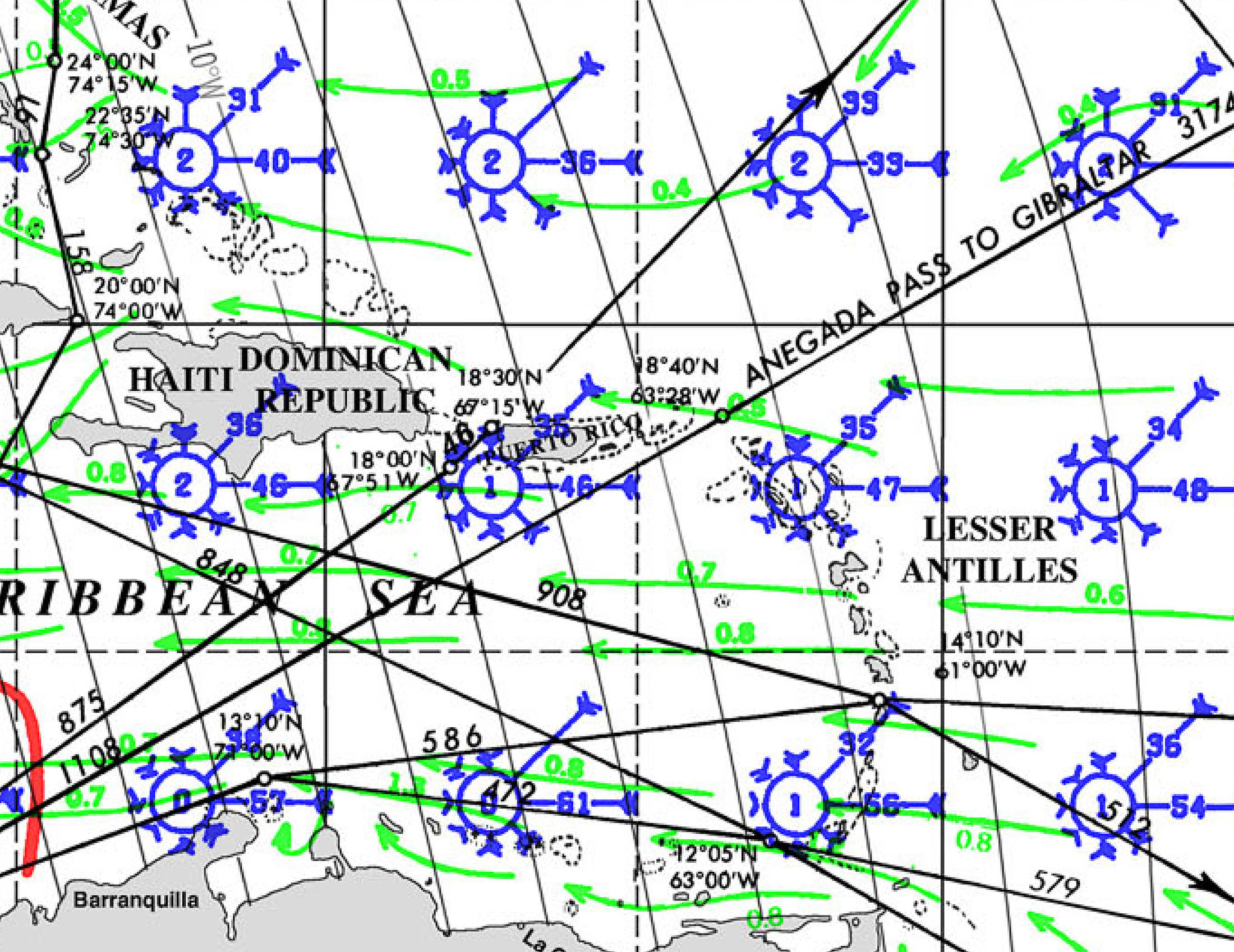
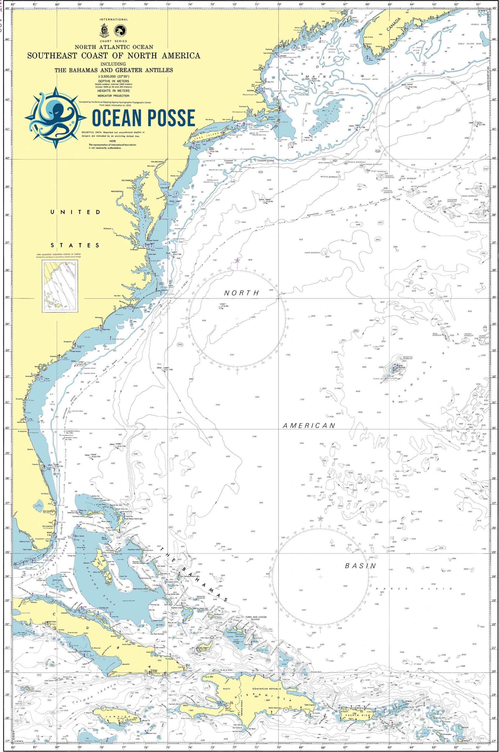
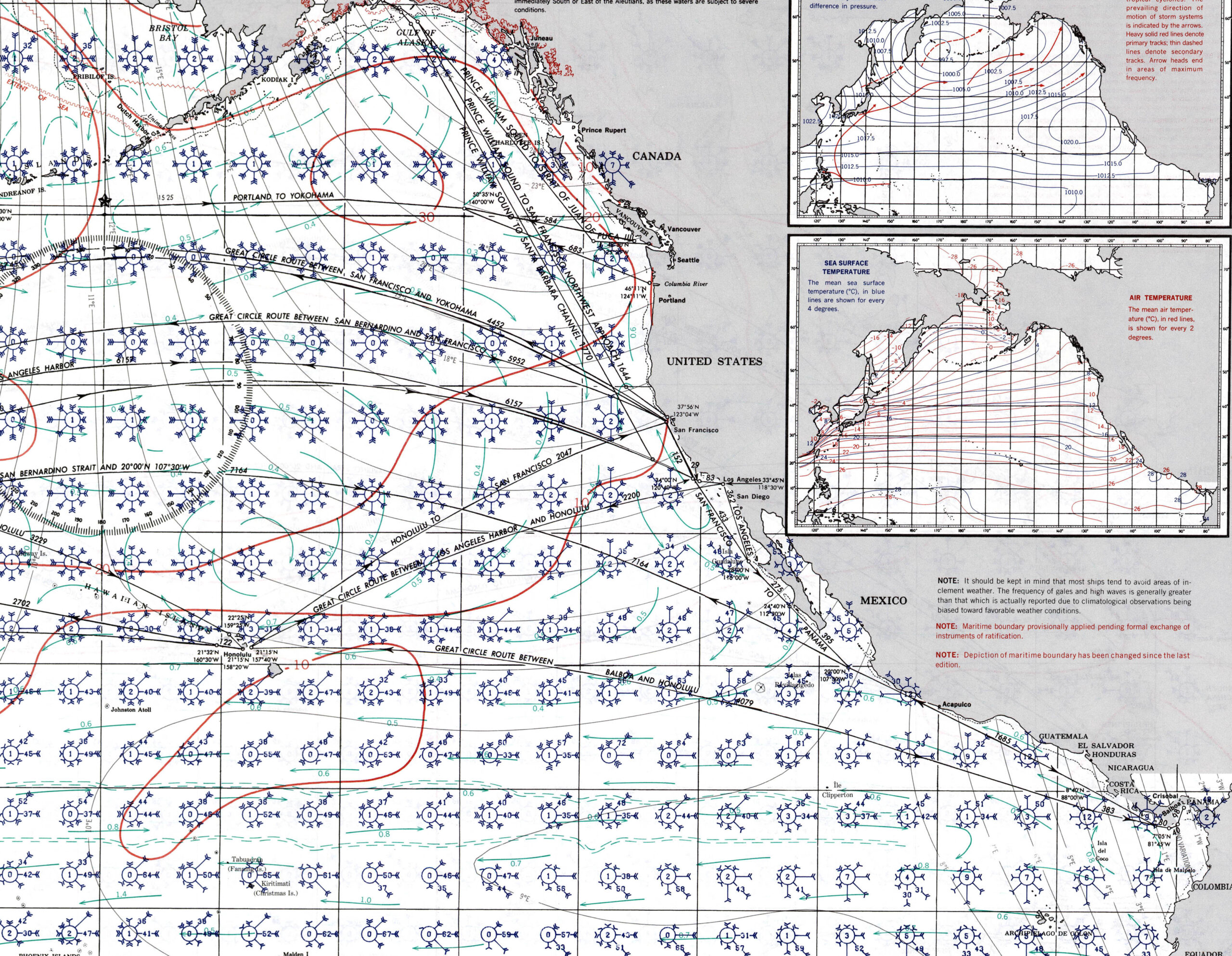
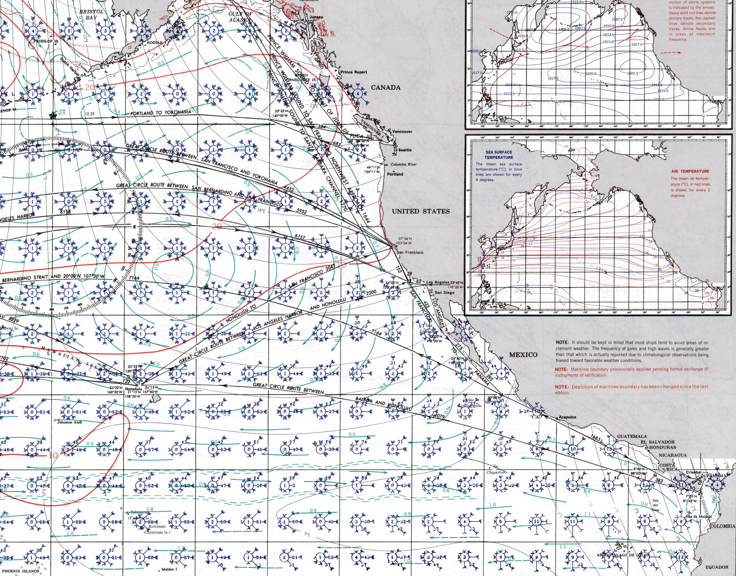
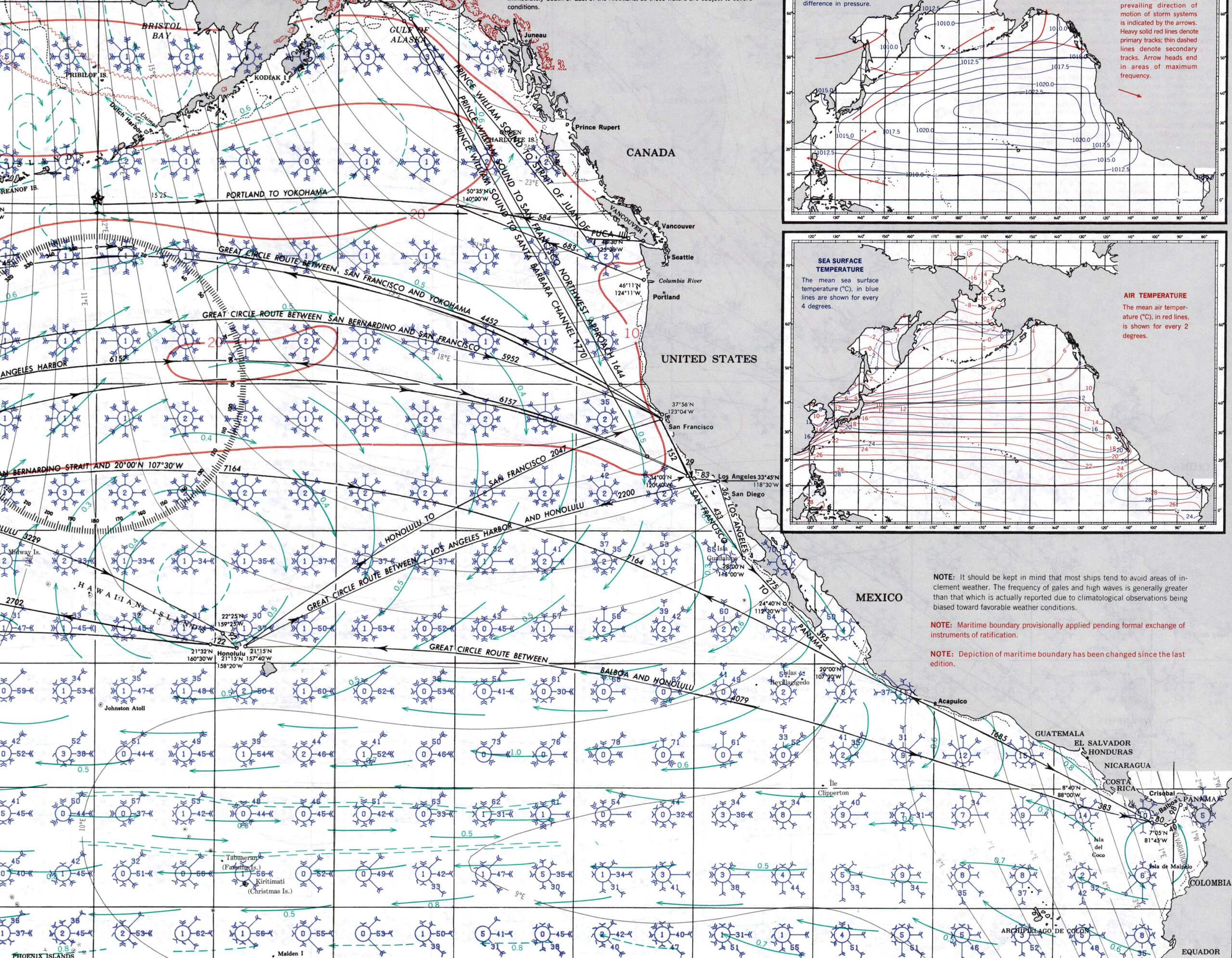
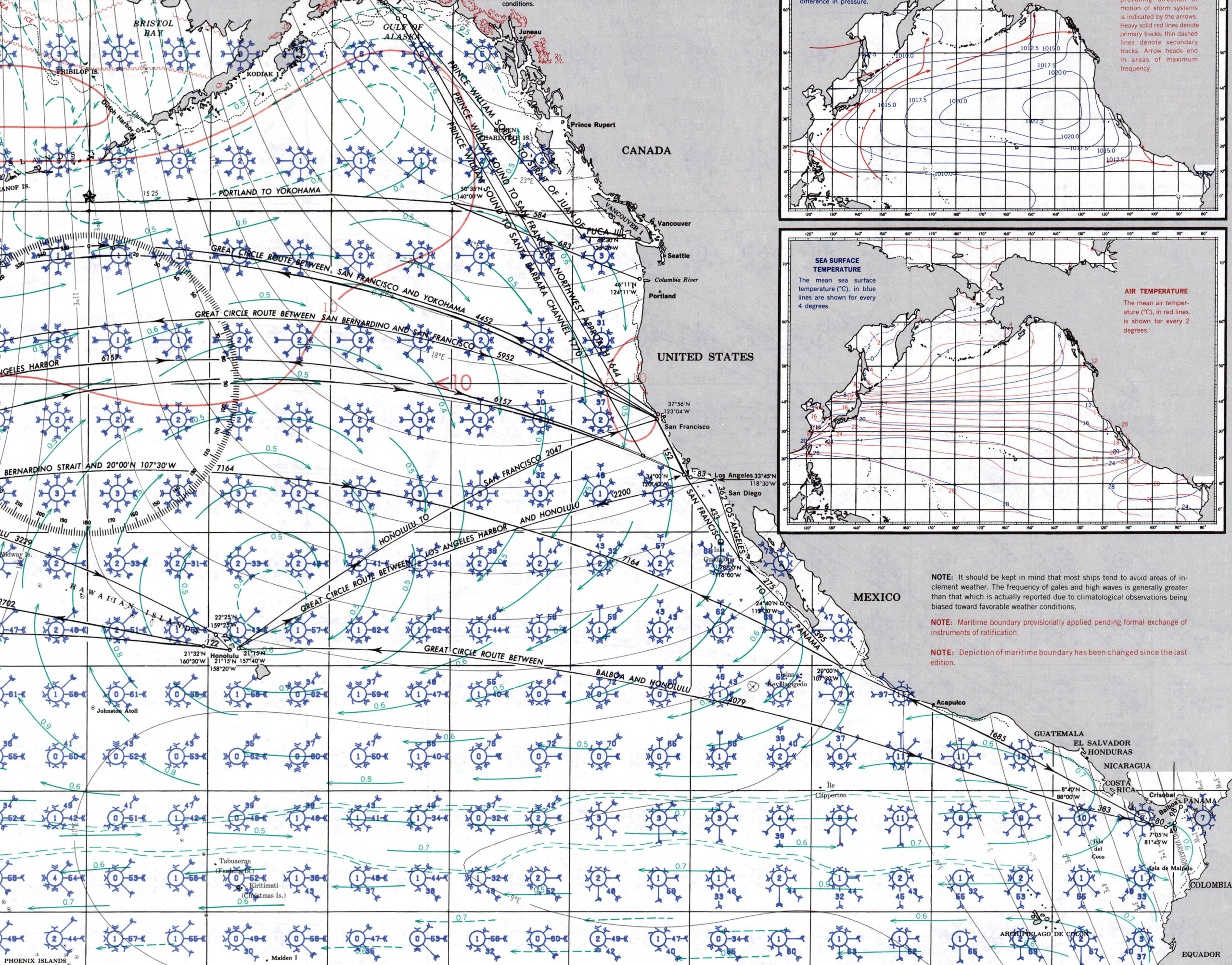
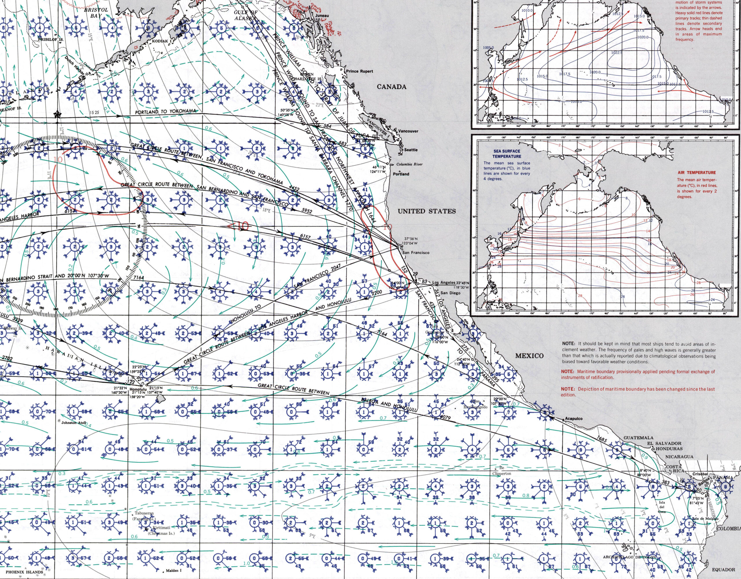
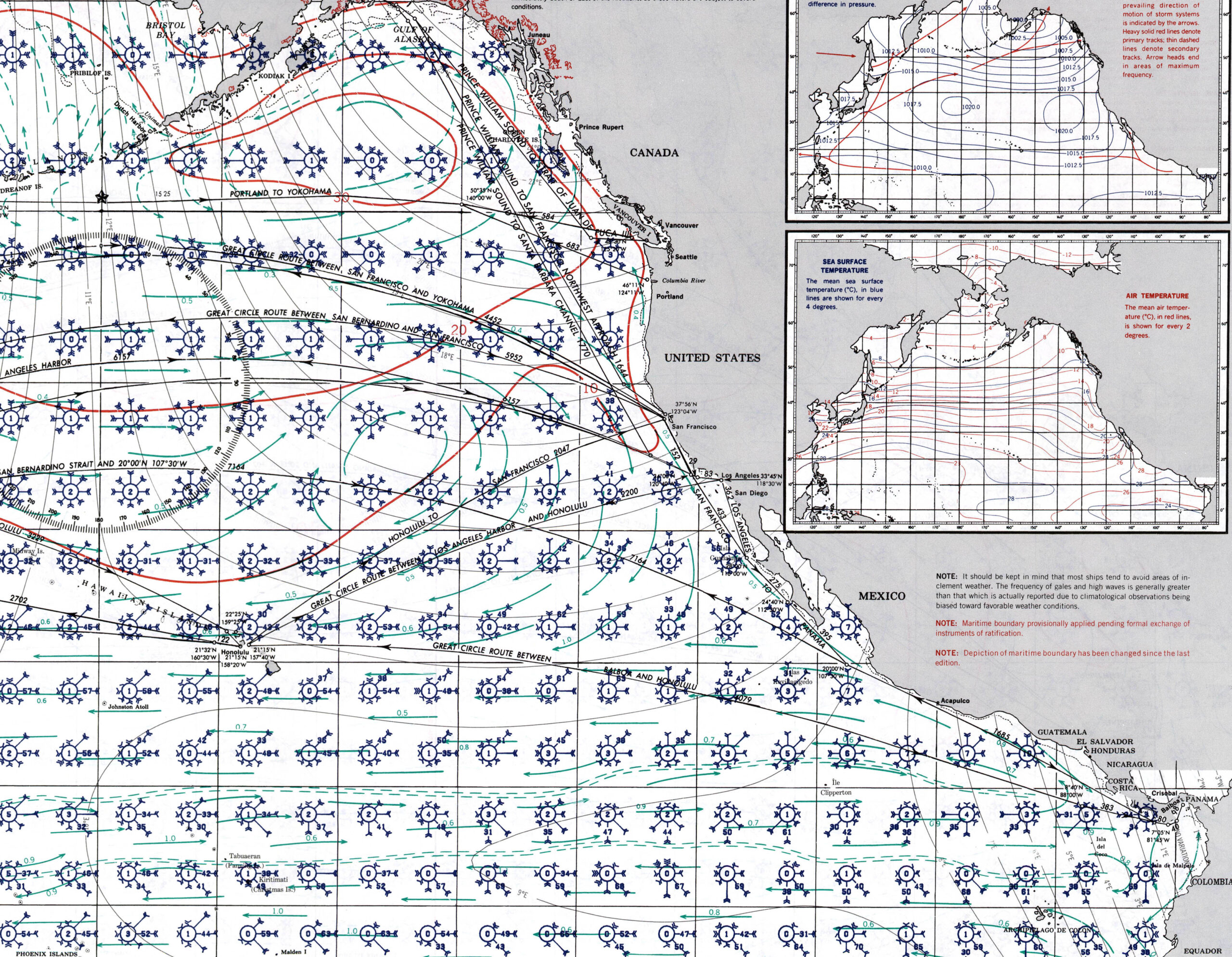
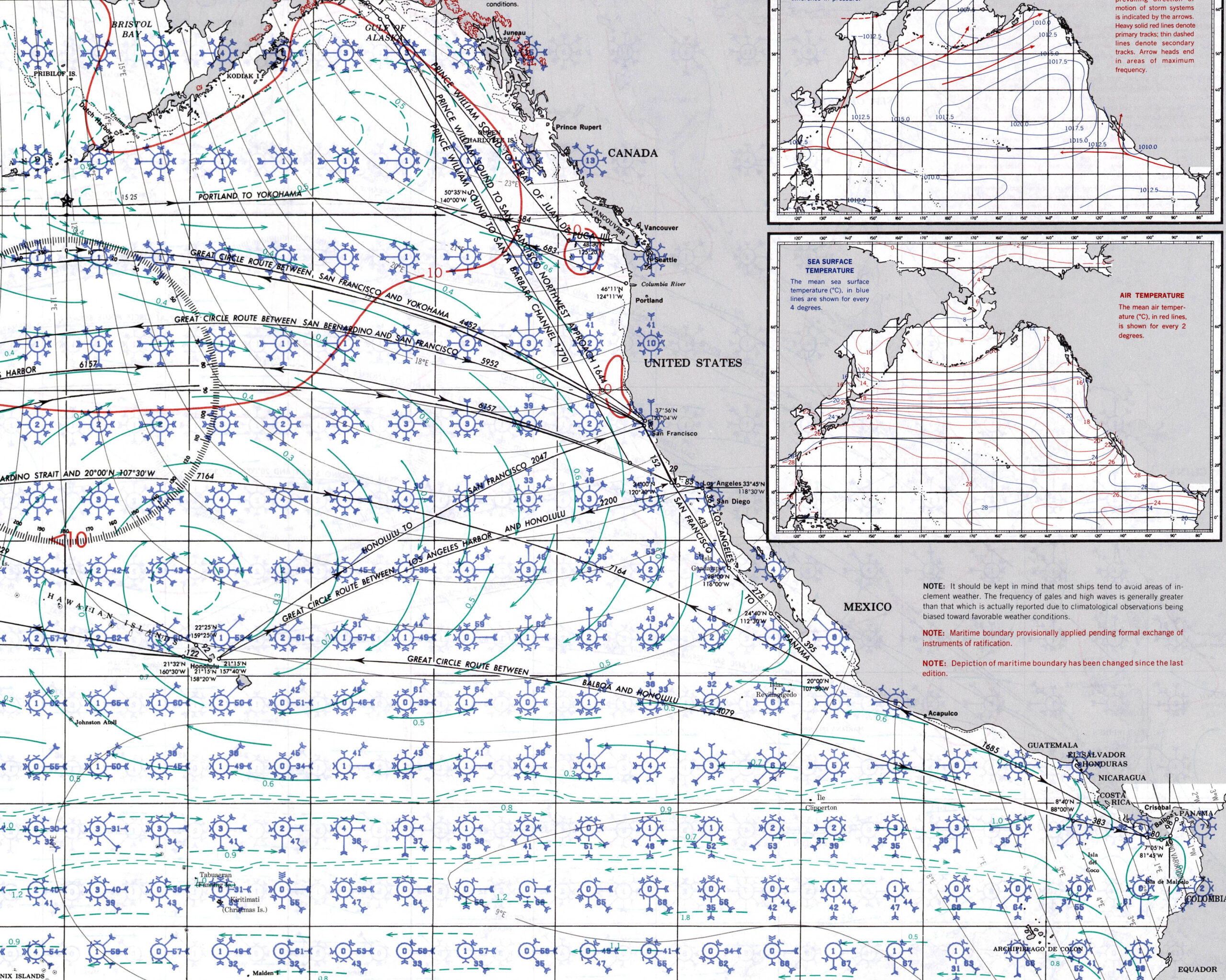
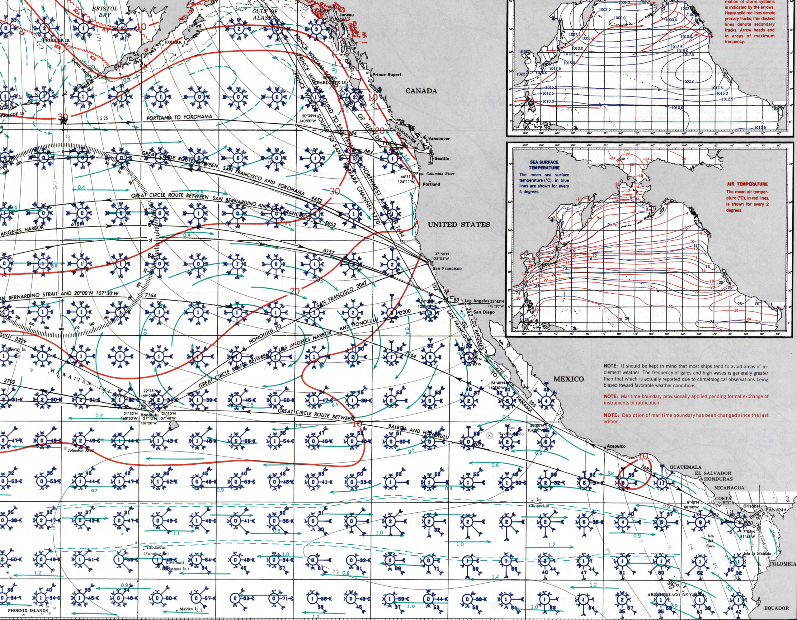
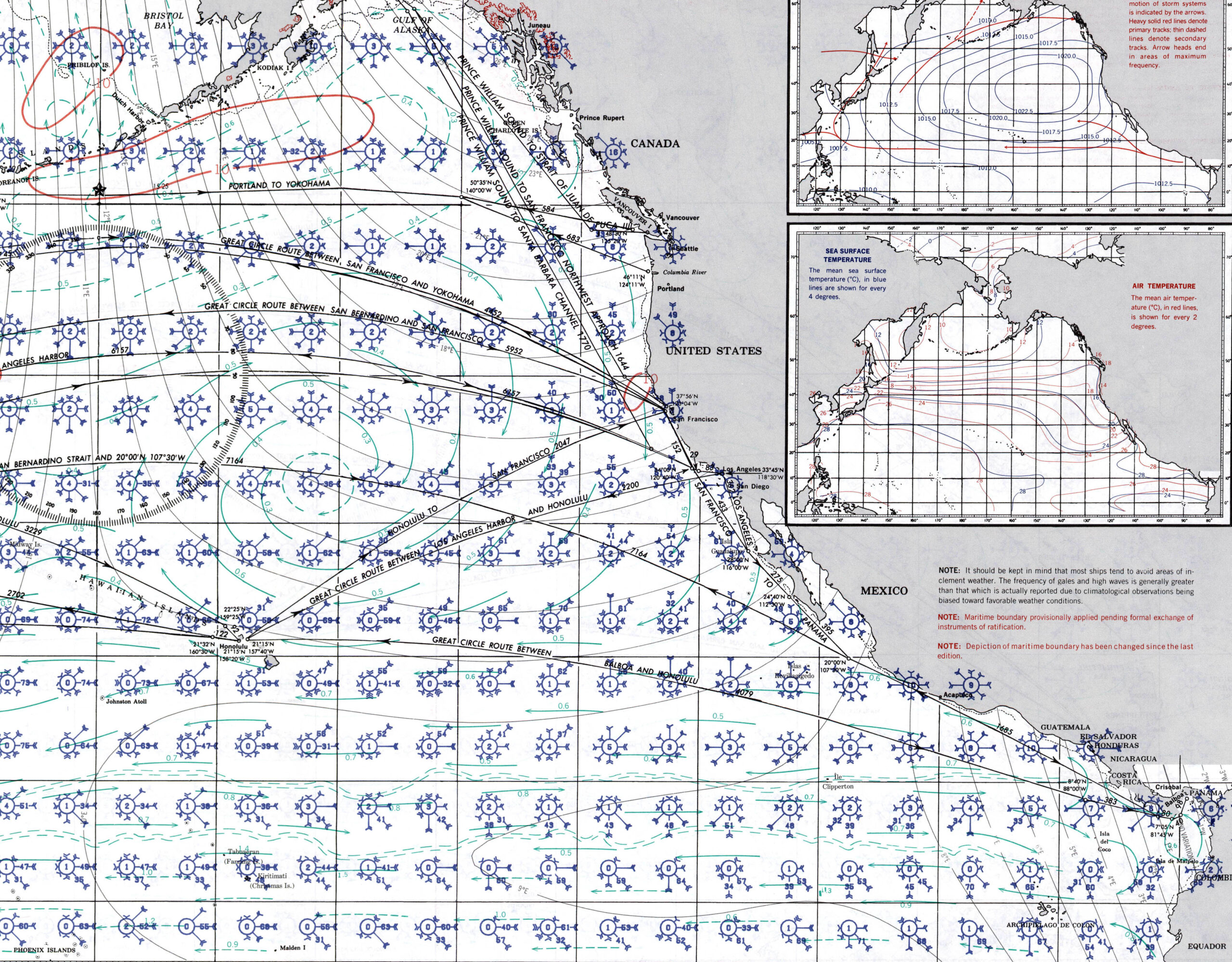
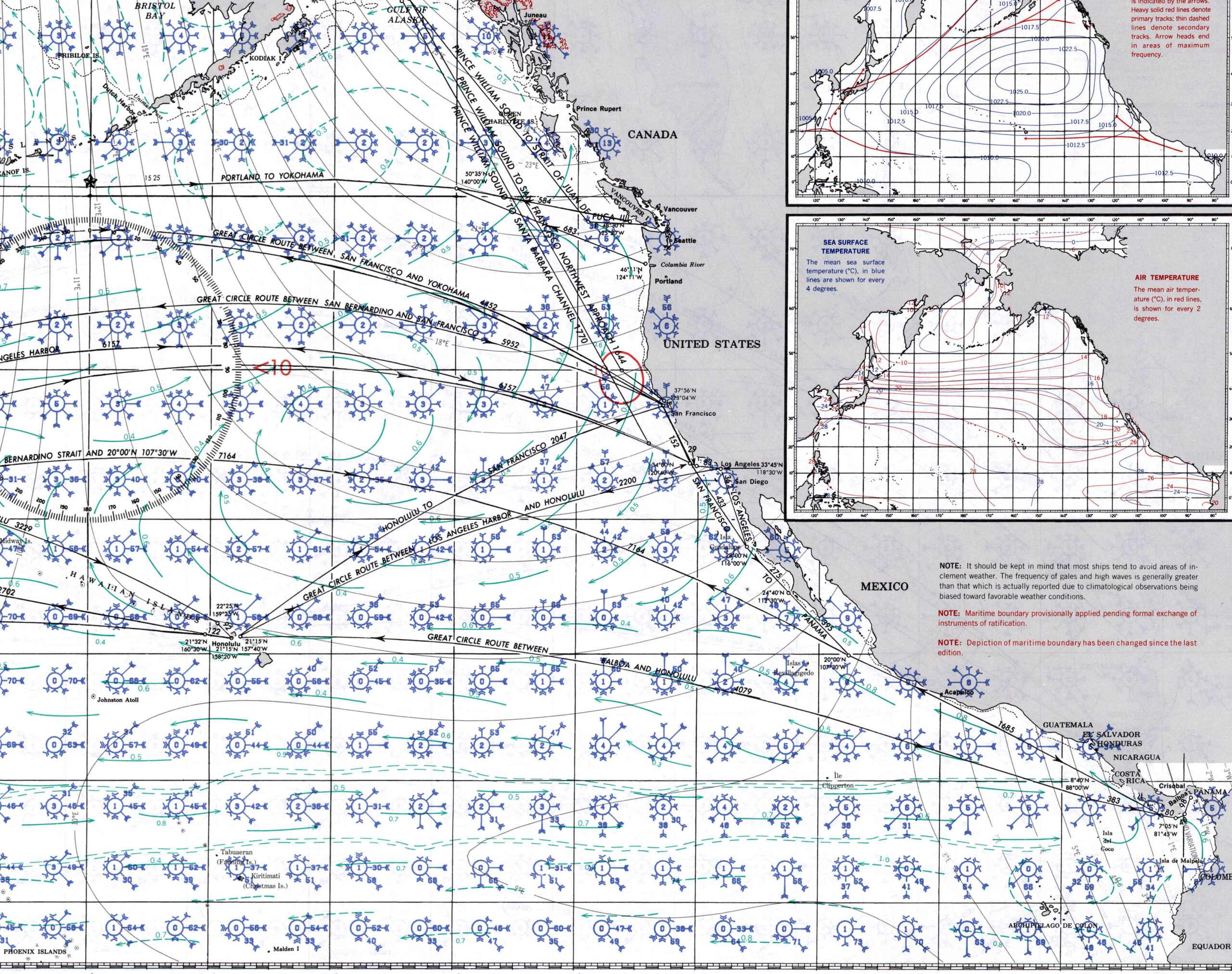
NEW ZEALAND PILOT CHARTS
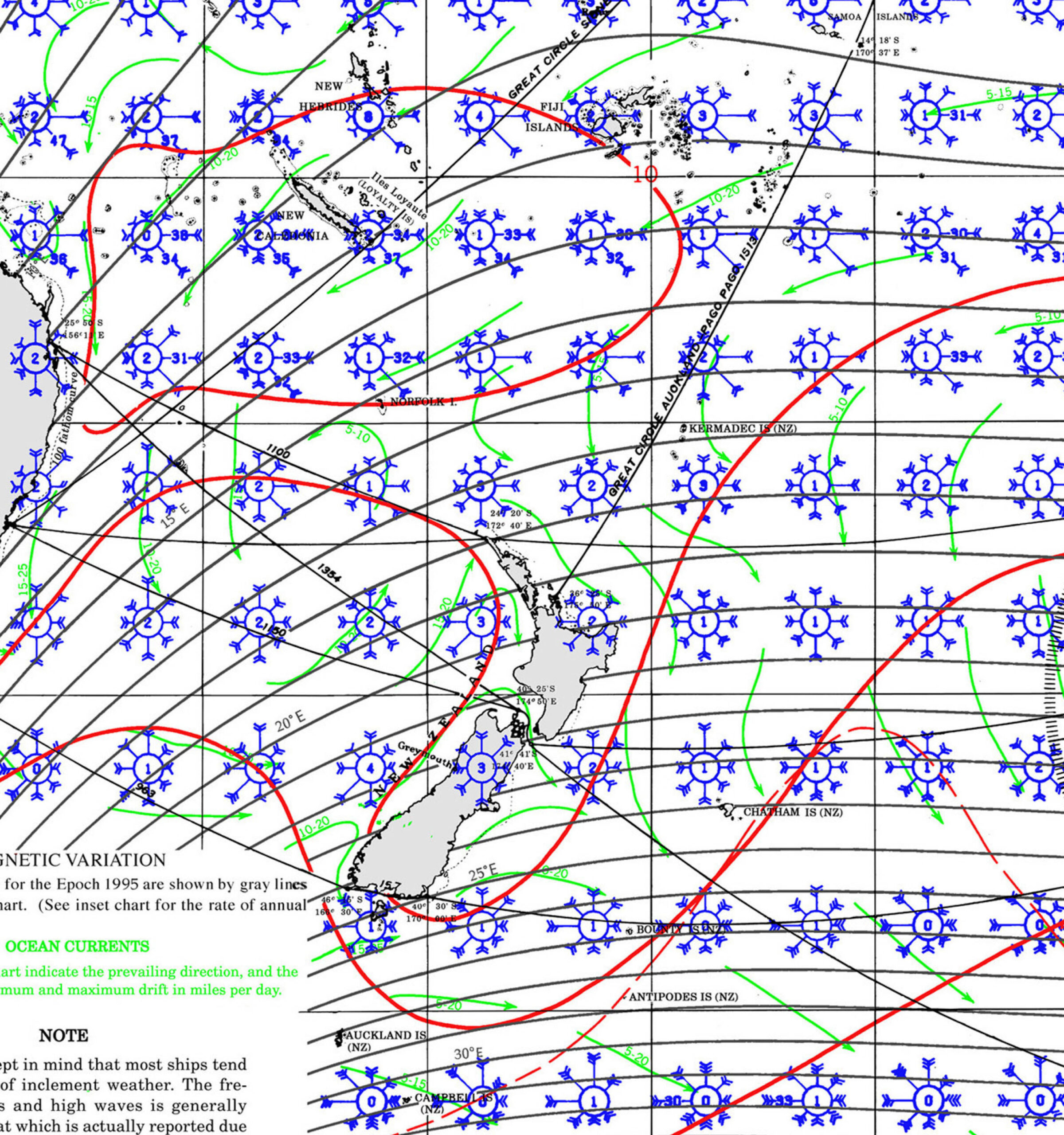
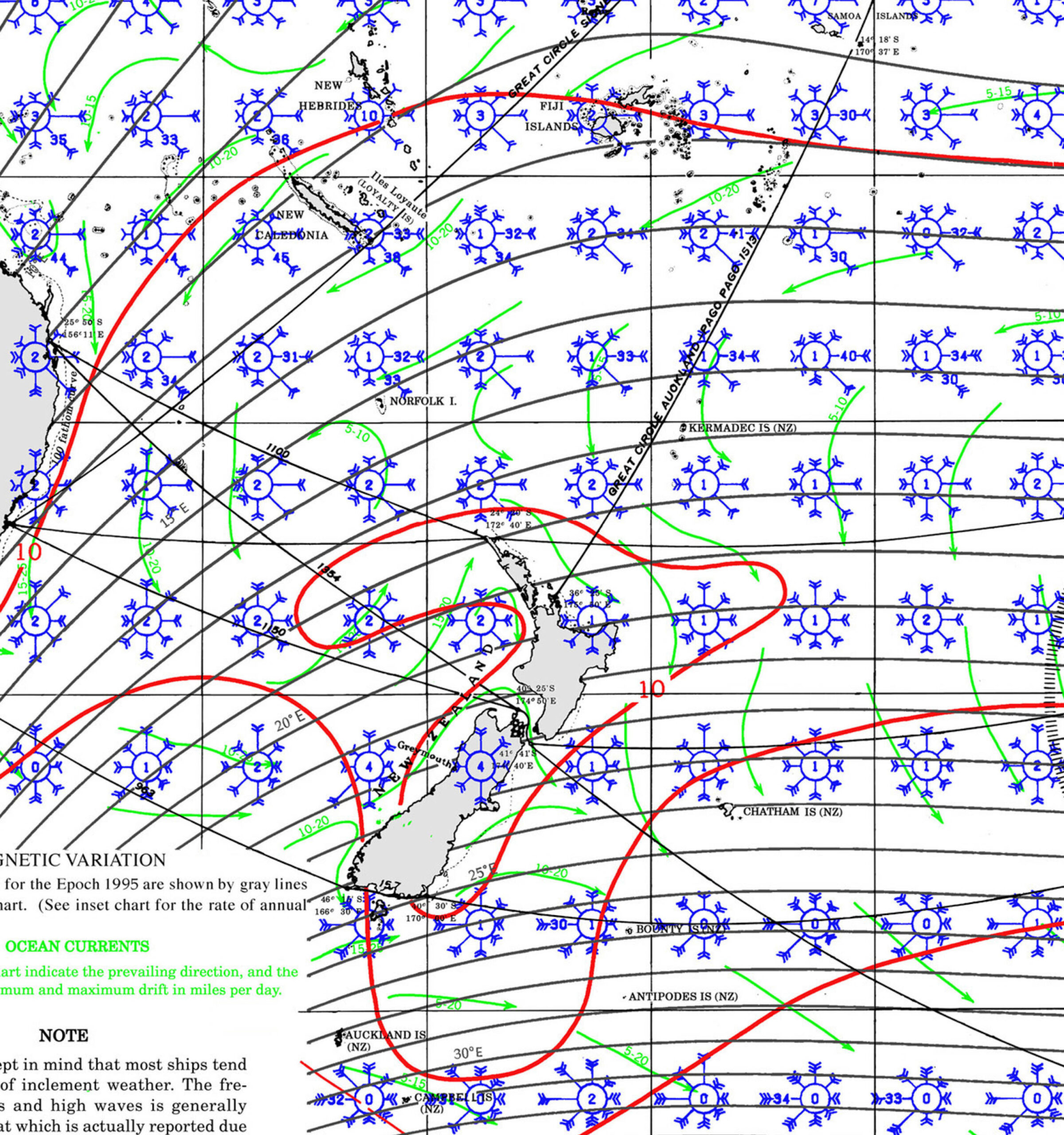
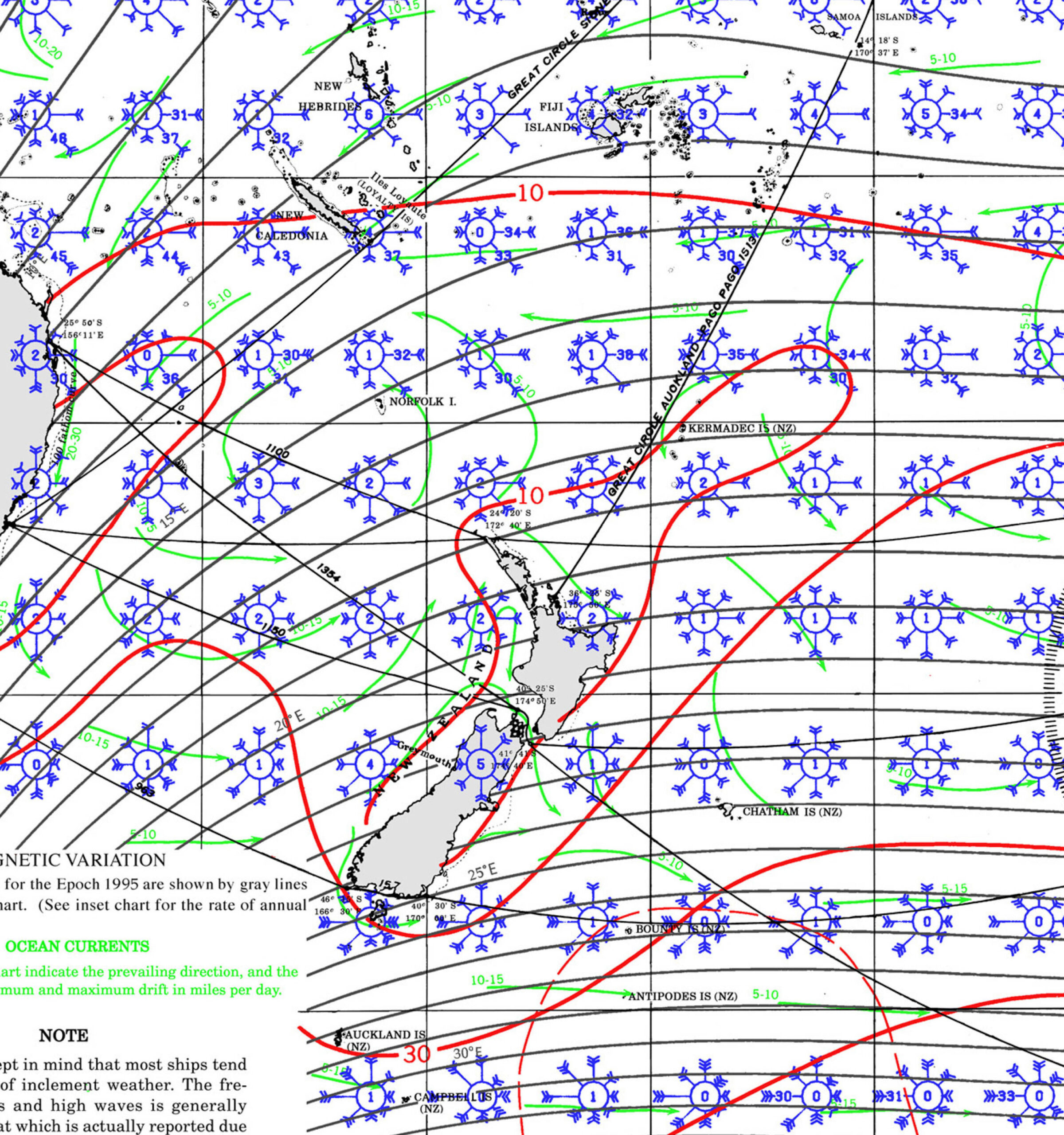
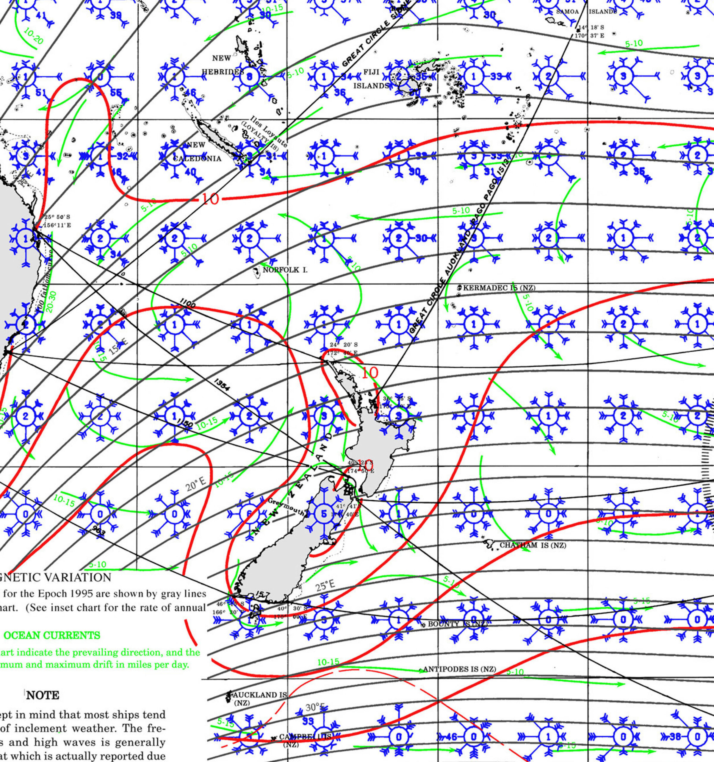
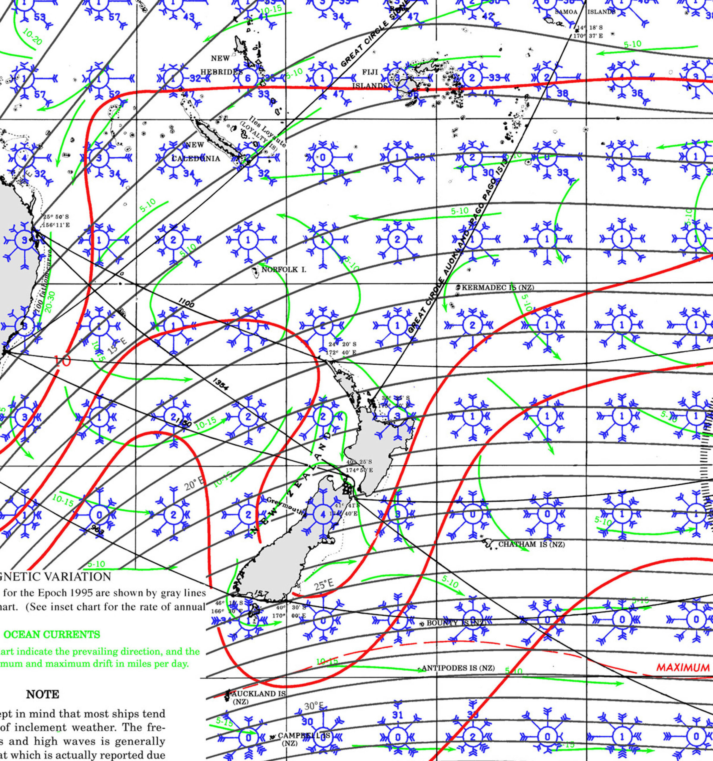
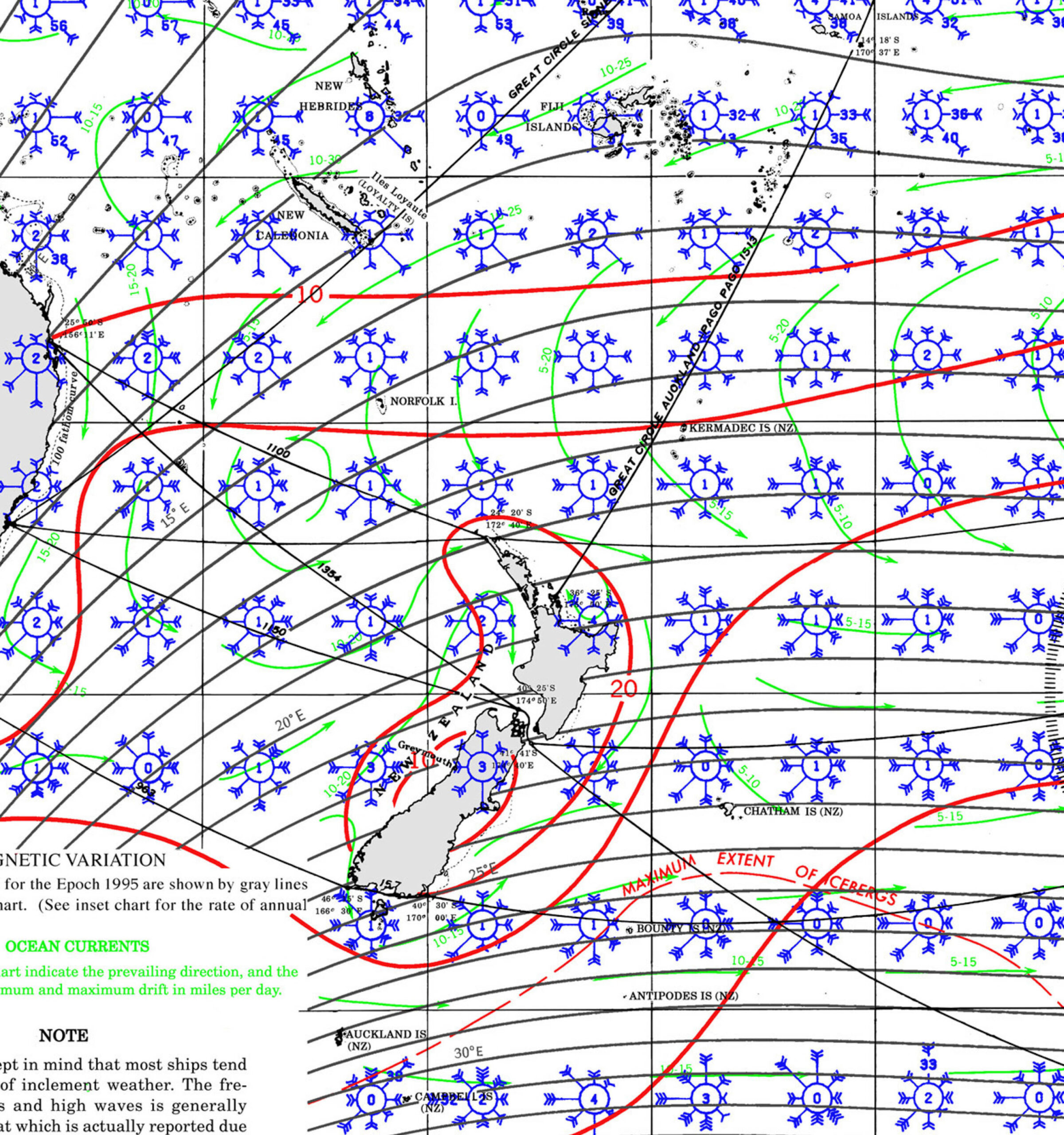
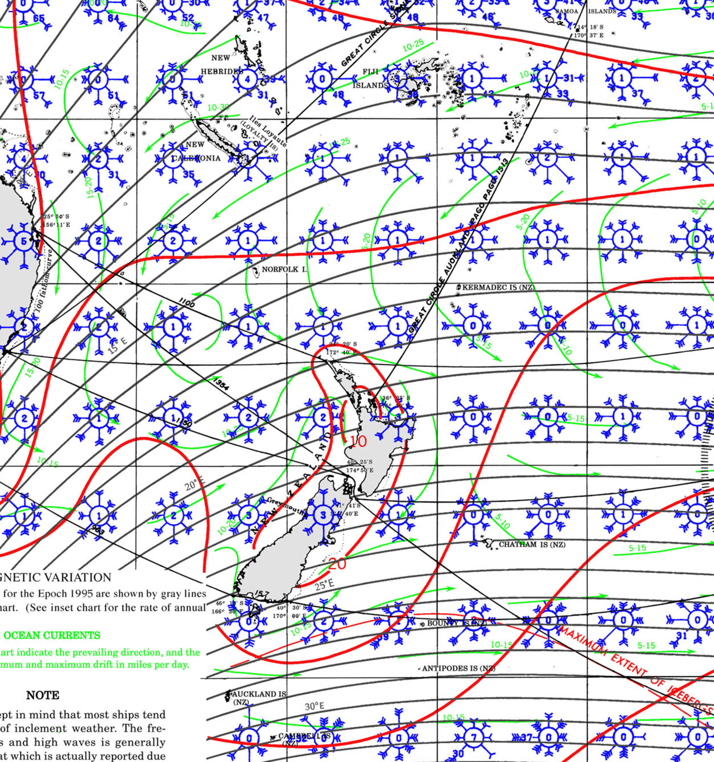
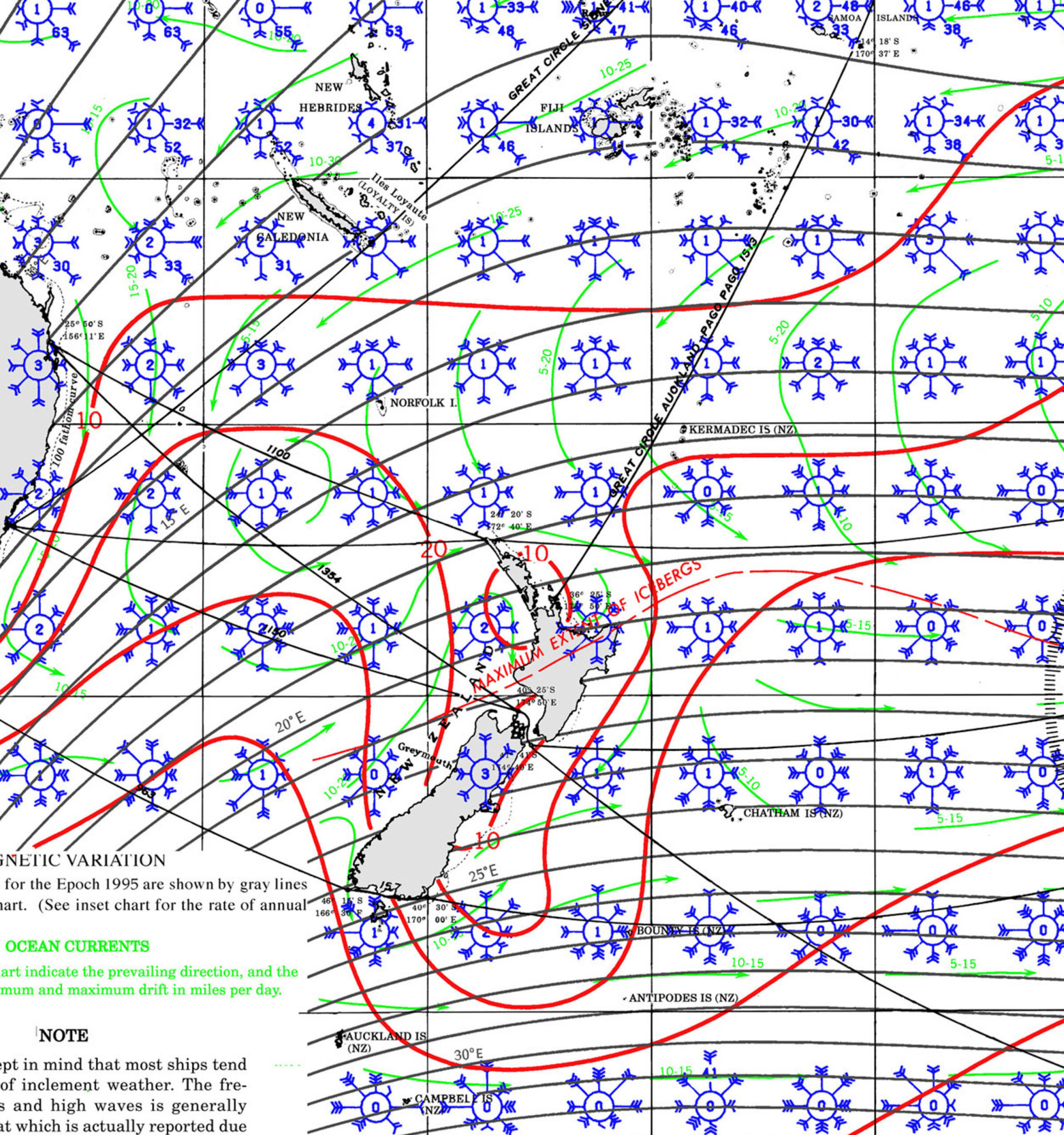
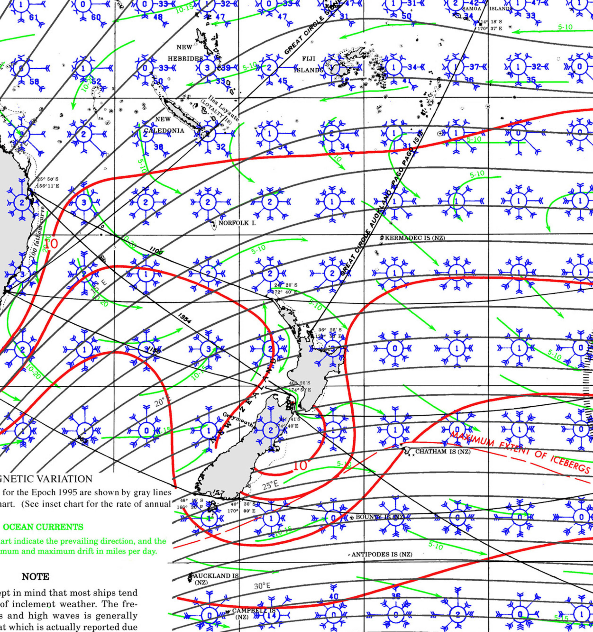
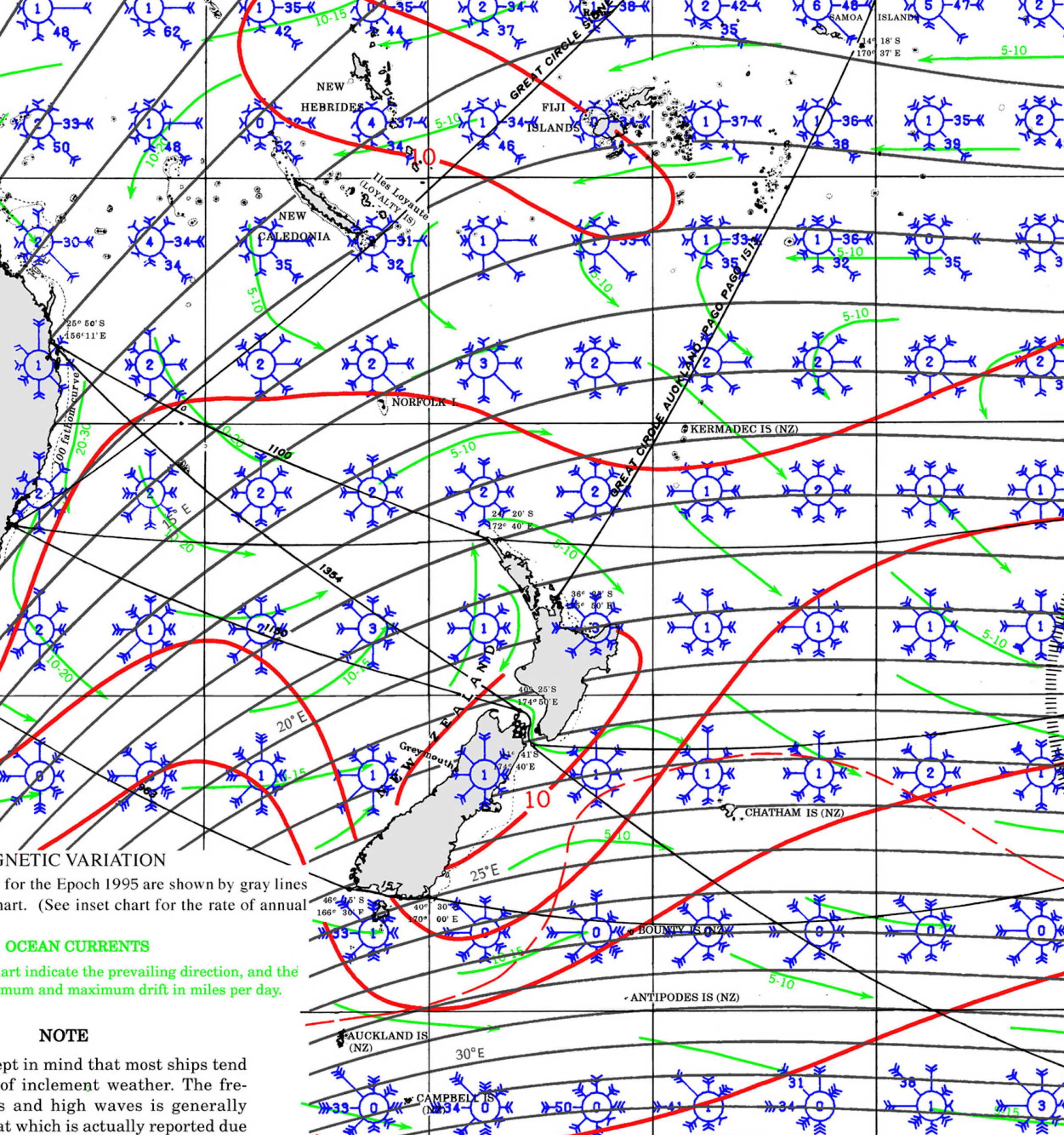
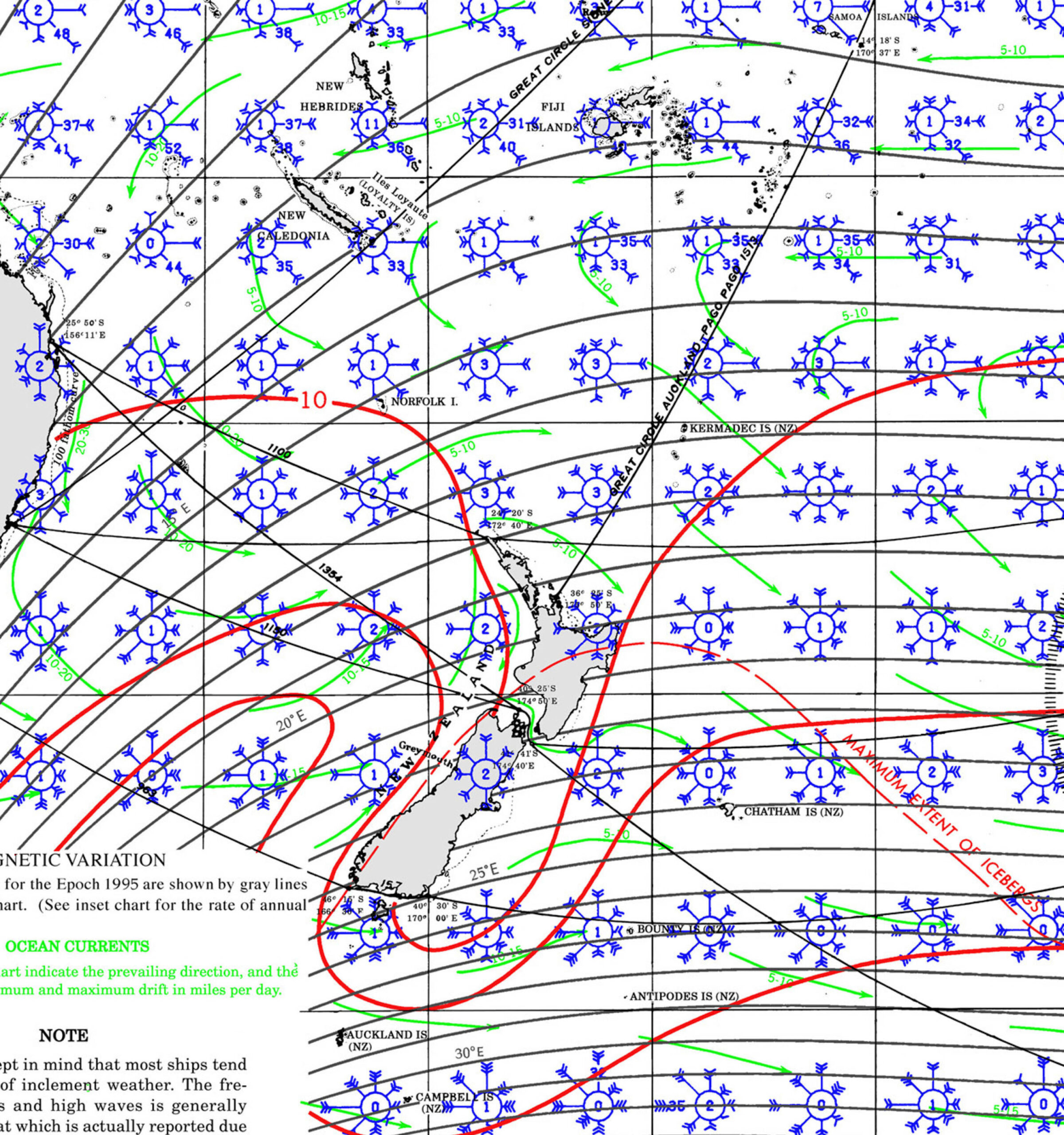
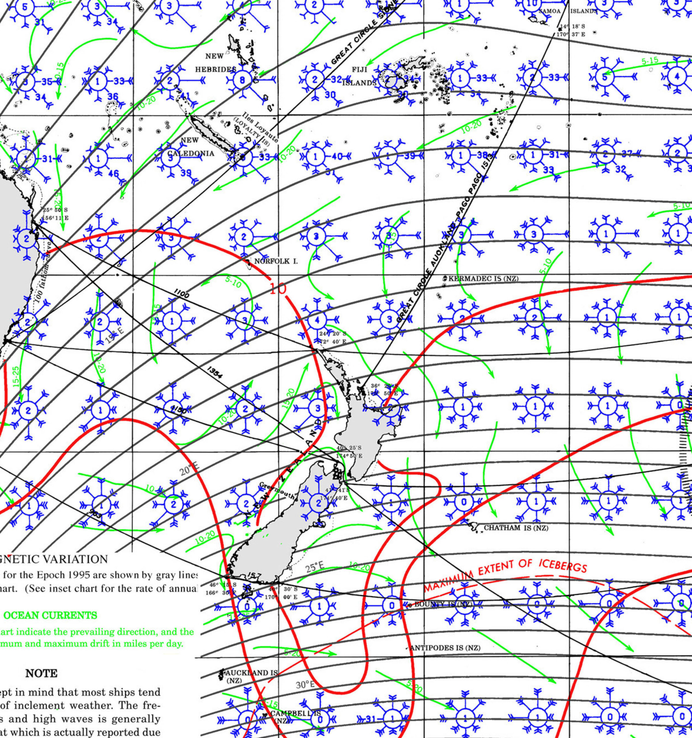
NEW ZEALAND Pilot Charts provide historic points and aggregated information of wind flows, air and ocean temperatures, wave heights, rain, barometric weight, and climate conditions at various seasons. This data was acquired from oceanographic and meteorologic perceptions over hundreds of years starting in the late eighteenth century. These diagrams are planned to help mariners choose routes around and approaching Cuba with respect to the normal climate and sea conditions using prevailing seasonal wind information.
PORTS OF ENTRY
DOCUMENTS
ENTRY EXIT REQUIREMENTS
| DOCUMENTATION | |||||||||||||||
| ENTRY AND EXIT PROCEDURES | Here is the Complete website and requirements including visas and TIP https://www.customs.govt.nz/personal/travel-to-and-from-nz/recreational-vessels-yachts-and-small-craft/ |
||||||||||||||
| Passport | Non NZ – AUS citizens | ||||||||||||||
| Boat Documentation | Coast Guard Doc (Original) | ||||||||||||||
| Insurance | |||||||||||||||
| Crewlist | Required at checkin/out | ||||||||||||||
| Zarpe | Required at checkin/out | ||||||||||||||
| Fishing License | |||||||||||||||
| Official Procedures | THE FOLLOWING ITEMS ARE NOT ALLOWED TO BR BROUGHT INTO NEW ZEALAND MAF BIO-SECURITY WILL DESTROY THE FOLLOWING ITEMS | ||||||||||||||
| Official Country Visa | |||||||||||||||
| Immigration Visa | NZ JUNE 2022 https://www.immigration.govt.nz/new-zealand-visas/apply-for-a-visa/about-visa/travelling-by-private-yacht-or-aircraft-visitor-visaVisa applications open for travellers located in Pacific countriesFrom 16 May 2022 you can apply for a visitor visa to travel to New Zealand, but only if you are applying from one these Pacific Island Forum countries:the Cook Islands Federated States of Micronesia Fiji French Polynesia Kiribati New Caledonia Nauru Niue Palau Papua New Guinea Republic of the Marshall Islands Samoa Solomon Islands Tonga Tuvalu VanuatuYou can apply if you are a citizen of another country. But you must be applying from one of these Pacific Island forum countries.Travel conditionsPeople coming from most Pacific countries need to be eligible to travel to New Zealand. Eligible travellers include:New Zealand citizens or residents Australian citizens or permanent residents people who have a border exception, or people who are exempt from the border restrictions, or people who hold a valid temporary entry visa.With this visa you canVisit New Zealand on a private yacht or aircraft. Travel in and out of New Zealand for up to 3 months. Include your partner, and dependent children aged 19 and under, in your visa application.Entry permissionYou must apply for entry permission at an Immigration Control Area when you arrive in New Zealand by presenting yourself to an Immigration Officer within 72 hours of your arrival.Immigration Control AreaYou can be refused entry permission if:you do not meet our character requirements your circumstances have changed since you were granted a visa you refuse to let us take your photo or to provide us with your fingerprints or an iris scan, if asked for them you are unable to provide evidence of any onward travel or funds required by the conditions of your visa.If you are refused entry to New ZealandBefore you travel to New Zealand TravelIf travelling in and out of New Zealand, a valid multiple entry travel condition is needed to return to New Zealand.Changing the conditions of a visitor visa If applying from inside New Zealand, we will normally give multiple entry travel conditions when we grant a student visa. If there are no multiple entry travel conditions and you leave New Zealand, the visa will expire. The travel conditions will be listed on the visa label, or in a visa letter. If you’re leaving New Zealand by commercial transport, you must have a ticket to leave New Zealand to a country you have the right to enter or enough money to buy one. If living on board a yacht, you must have NZ $400 a month to live on while in New Zealand or a sponsor. Acceptable sponsors You cannot work in New Zealand on this visa. You must leave New Zealand before your visa expires. You can apply for more visas to allow you to stay up to 9 months. Or up to 12 months, if: your yacht or aircraft needs repairs |
||||||||||||||
| Required Permits | |||||||||||||||
| Upon Arrival Visit: | Immigration; Customs; Port Captain/Authority | ||||||||||||||
| Upon Departure Visit: | Immigration; Customs; Port Captain | ||||||||||||||
| Total Entry & Exit Fees: | |||||||||||||||
| Notes: | |||||||||||||||
| Recommended Agent: |
|
||||||||||||||
| Other: | |||||||||||||||
| Required Vaccinations | None | ||||||||||||||
| Pets | MAF regulations prevail -> expect to pay 5000 – 1000 usd x animal Bio security rules – to get you started with this process follow this link >>> | ||||||||||||||
| Currency: New Zealand dollar |
|
MUST SEE
- Waiheke Island: Known for vineyards and beaches. Ideal in summer (December to February). Check Out Stonyridge
- Waitomo Caves: Explore glowworm-lit caves. Accessible year-round; spring (September to November) offers mild weather.
- Hobbiton Movie Set: Tour the iconic film set. Open year-round; spring and autumn (March to May) provide pleasant conditions.
- Rotorua Geothermal Areas: Experience geysers and hot springs. Best in autumn and spring for comfortable temperatures.
- Te Puia: Discover Māori culture and geothermal wonders. Year-round destination.
- Lake Taupō: Engage in water sports and fishing. Summer is ideal for outdoor activities.
- Tongariro Alpine Crossing: Hike through volcanic landscapes. Best in summer; check weather conditions.
- Mount Taranaki: Hike or photograph this symmetrical volcano. Summer offers clear views.
- Coromandel Peninsula: Visit Hot Water Beach and Cathedral Cove. Summer is perfect for beach activities.
- Bay of Islands: Explore 144 islands by boat. Summer provides warm weather for sailing.
- Cape Reinga: Visit the northernmost point where two oceans meet. Accessible year-round; summer offers longer daylight.
- Ninety Mile Beach: Drive along this expansive beach. Best in summer; ensure to check tide schedules.
- Wellington: Explore the capital’s museums and cafes. Year-round destination; summer has festivals.
- Te Papa Museum: Discover New Zealand’s history and culture. Open year-round.
- Weta Workshop: Tour the studio behind famous film effects. Year-round attraction.
- Napier: Admire Art Deco architecture. Best during the Art Deco Festival in February.
- Hawke’s Bay: Enjoy wine tasting tours. Autumn (March to May) is harvest season.
- Gisborne: Be the first to see the sunrise. Summer offers clear mornings.
- East Cape Lighthouse: Visit the easternmost point. Accessible year-round; summer provides better weather.
- Whanganui River: Canoe through scenic landscapes. Summer is ideal for water activities.
- Auckland Sky Tower: Enjoy panoramic views of the city. Best visited year-round.
REPAIRS AND SERVICE PROVIDERS
New Zealand’s offers a comprehensive range of marine services catering to various needs, from vessel maintenance and repairs to marine construction and diving operations. Below is an overview of notable providers across the region:
Features two travel lifts: one with a 100-tonne capacity and 7.8m beam, and another with a 30-tonne capacity. Offers hardstand services for maintenance and storage.
Operates a 50-tonne travel lift and a 60-tonne haul-out trailer, providing comprehensive boatyard facilities and 20 dedicated work berths.
Utilizes a 70-tonne travel lift and offers hardstand space for 50–60 boats, along with on-site marine services.
Equipped with a 12m-wide boat haul-out ramp and a Roodberg HBC80-VEL hydraulic slipway trailer, capable of handling vessels up to 35m in length and 80 tonnes.
Offers dual travel lifts: a 100-tonne lift for vessels up to 10m beam and a 560-tonne lift for vessels up to 13.5m beam, along with extensive hardstand and refit facilities.
Operates two travel lifts with lifting capacities of 35 and 75 tonnes, providing a range of services including lifting, water blasting, and anti-fouling.
Situated within Tauranga Bridge Marina, this facility offers a professional boat haul-out service with hardstand facilities for 30 freestanding vessels.
Features a travel lift capable of lifting vessels up to 44 tonnes and 5.4m beam, along with a dedicated visitor dock and hardstand services.
These facilities provide a range of services, including lifting, maintenance, and storage, catering to various vessel sizes and requirements.
1. Marine Pro
Specializing in marine operations throughout the Hauraki Gulf and the North Island, Marine Pro offers services including vessel support, marine logistics, and biosecurity compliance. Their fleet is equipped to handle diverse marine-based operations.
2. Bay Providors
Serving most North Island ports, Bay Providors is a one-stop shop for marine services, stores, and provisions. They supply bonded stores, cabin stores, medical supplies, navigation equipment, and more, ensuring vessels are well-equipped for their voyages.
3. METCO Marine Services
Operating under METCO Group, they provide marine surveys, consultancy, and management services. Their expertise extends to large yacht sales and purchases, as well as materials testing, catering to both marine and construction sectors.
4. Price Provedors
With a professional network across all North Island ports, Price Provedors offers ship supplies, equipment, and technical support. They are approved food distributors by New Zealand’s Ministry of Primary Industries and operate customs-bonded stores.
5. Lakeland Marine
Based in Taupo, Lakeland Marine specializes in new and used boat sales, parts, and servicing. They are authorized dealers for Bayliner boats and Mercury Marine engines, providing comprehensive support for recreational boating.
6. Marine Services Auckland Limited (MSAL)
A New Zealand-owned company, MSAL specializes in marine support, including salvage, heavy marine transport, wreck removals, and construction projects. With over 40 years of experience, they offer 24-hour support across the North Island.
7. Total Marine Group
Providing marine construction, engineering, and dredging services, Total Marine Group operates in New Zealand and beyond. They are committed to environmentally sustainable practices and offer cost-effective solutions to clients.
8. Walker Marine Services Ltd
With over 25 years of surveying experience, Walker Marine Services covers nautical investigations, cargo surveys, and marine insurance claims. Their expertise spans various types of marine work, ensuring comprehensive support for maritime operations.
CUSTOMS AND LOGISTICS
Advanced Customs Service Ltd
Auckland, New Zealand.
PH: +64 (09) 307 9050 MB: +64 021 216 6600
FAX: +64 (09) 307 9120
E-MAIL: td@advancedcustoms.co.nz
www.advancedcustoms.co.nz
EMERGENCIES AND SAR INFO
SEAR AND RESCUE
JRCC NEW ZEALAND (RCCNZ)
Type: JRCC, Country: New Zealand, SRR: SRR NEW ZEALAND
Latitude, Longitude:
(-41.1883545,174.9449921)
Telephone:
+64 4 577 8030
Email:
Fax:
+64 4 577 8038 alternate fax: 64-4-577-8041
Website:
INMARSAT:
Sat-C (582)451 200 067
Telex:
Notes:
The NZSRR is bounded to the:
(a) West by meridian 163° 00’E.
(b) East by meridian 131° 00’W.
(c) South to the South Pole.
(d) North by a line joining:
25° 00’S., 163° 00’E.
25° 00’S., 180° 00’W.
05° 00’S., 171° 00’W.
05° 00’S., 157° 00’W.
30° 00’S., 157° 00’W.
30°00’S., 131° 00’W.

🇻🇺 VANUATU 🏝 83
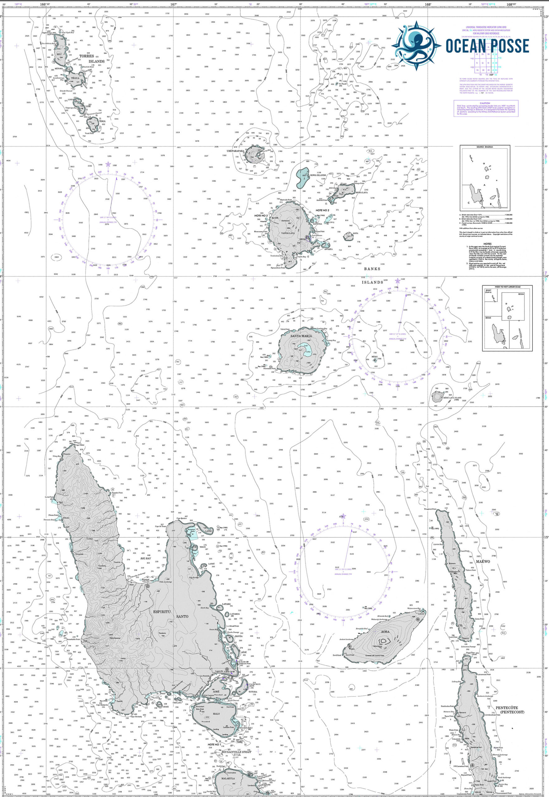
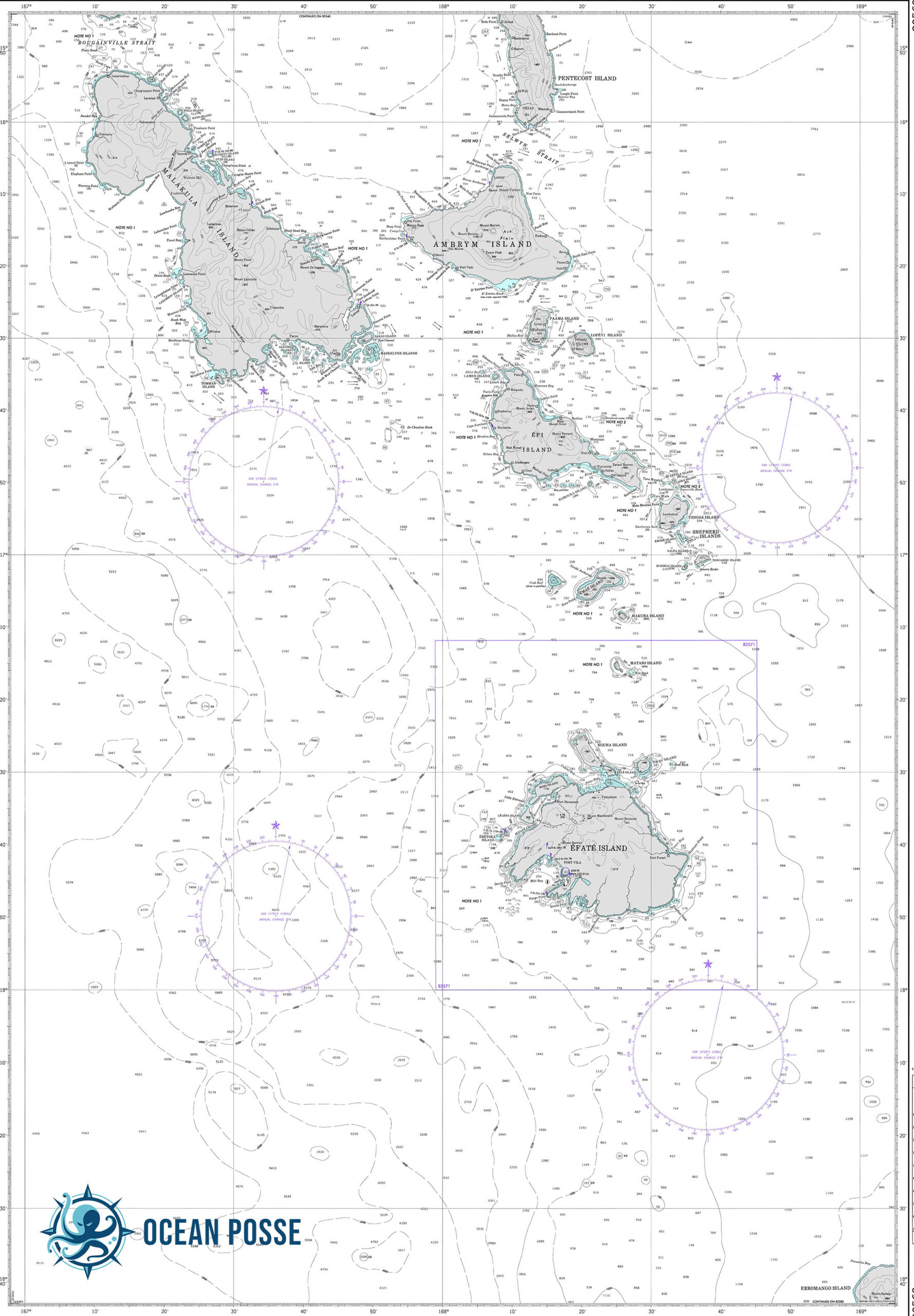
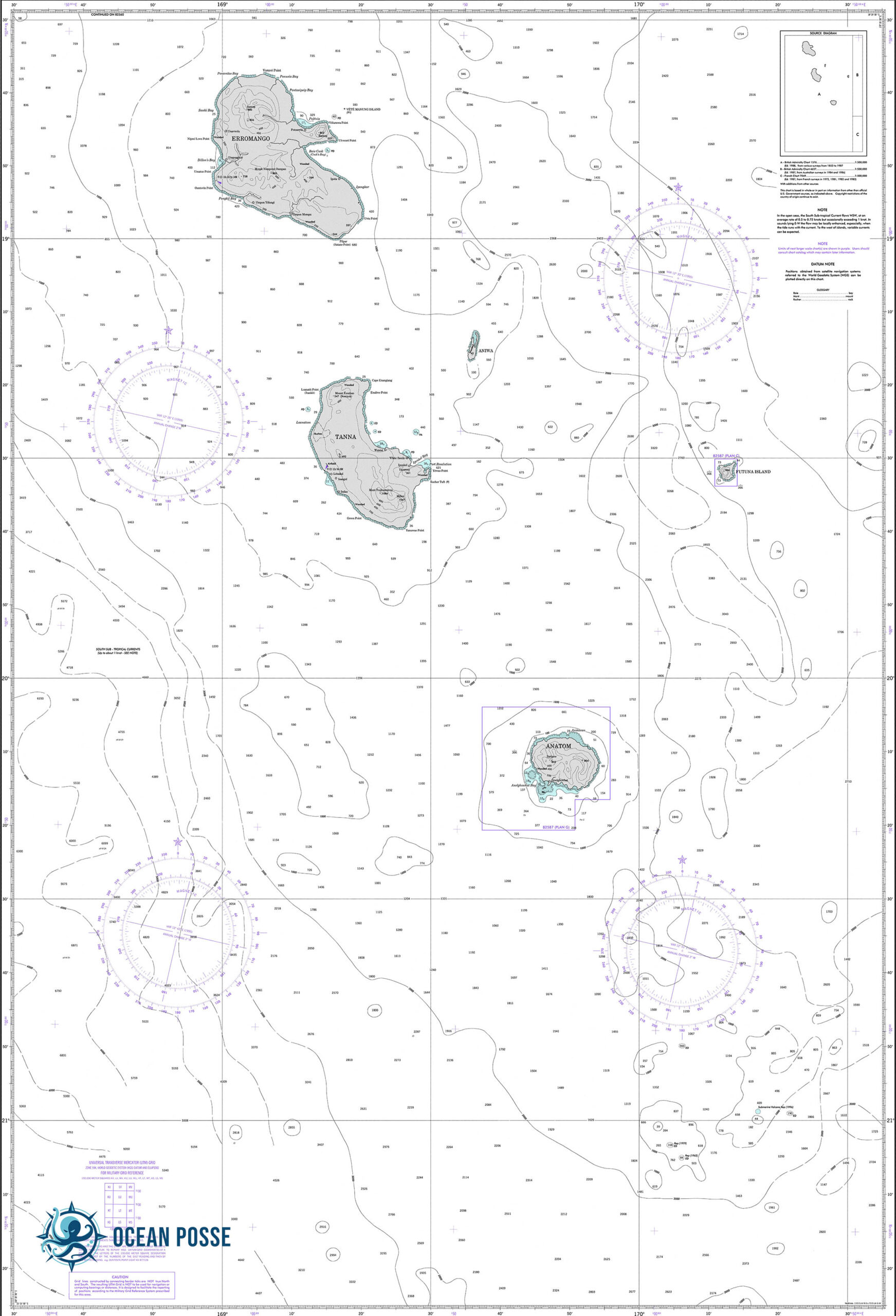
 Sailing and exploring in Vanuatu
Vanuatu offers a unique mix of adventure, exploration, and cultural immersion. Private yacht cruising allows unparalleled access to its hidden gems, from unspoiled beaches and coral atolls to welcoming villages and very unique and authentic traditions. With its rich diversity, this destination promises memories that will last a lifetime. It is on the top of he list for most circumnavigators.
Tanna Island: The Gateway to Adventure
- Port Resolution
Anchoring in Port Resolution offers a stunning introduction to Vanuatu. This natural harbor is well-protected and ideal for yachts. Meet the locals who will warmly greet you with their rich customs and island hospitality. - Mount Yasur Volcano
A short hike or a guided tour brings you to the rim of Mount Yasur, one of the most accessible active volcanoes in the world. The fiery display of erupting lava is a breathtaking experience, particularly at night. - Kastom and the Rom Dance
The Rom Dance is a unique kastom (custom) ceremony performed in traditional attire, often for special occasions. This dance, marked by its striking costumes and rhythmic chanting, is a cultural highlight of Tanna.
Erromango: History and Natural Beauty
- Dillon’s Bay
A quiet anchorage with beautiful beaches, Dillon’s Bay offers excellent opportunities for exploring the island’s rugged terrain and caves. - Cultural Encounters
The island is steeped in history, including early missionary stories. Engage with the locals to learn about their culture and traditions.
Efate: Home to Port Vila
- Port Vila
Vanuatu’s bustling capital, Port Vila, is a prime stop for provisioning, repairs, and exploring local markets. Enjoy French-influenced cuisine, duty-free shopping, and modern marinas. - Havannah Harbour
A tranquil anchorage with excellent snorkeling, fishing, and calm waters, Havannah Harbour offers a contrast to the lively Port Vila.
Epi and Pentecost Islands
- Epi Island
Anchor near Lamen Bay, known for its friendly dugong population. Snorkeling alongside these gentle creatures is a rare and memorable experience. - Pentecost Island: Land Diving
Witness the iconic Naghol (land diving) ceremony, considered the precursor to modern bungee jumping. Between April and June, men leap from towering wooden structures with only vines tied to their ankles in an incredible display of bravery and tradition.
Ambrym: The Black Magic Island
- Volcano Treks
The twin volcanoes, Benbow and Marum, dominate Ambrym’s landscape. Trekking these volcanoes offers otherworldly views of lava lakes. - Black Sand Beaches and Water Music
Ambrym’s black sand beaches are hauntingly beautiful, and the island is famed for its water music, where performers use water as an instrument to create hypnotic rhythms.
Espiritu Santo: Diving and WWII History
- Luganville
The second-largest town in Vanuatu, Luganville is an excellent hub for diving and exploring the island. Anchorages are abundant, and provisioning is convenient. - Diving the SS President Coolidge
This WWII wreck is one of the world’s most accessible and impressive dive sites, teeming with marine life and historical artifacts. - Blue Holes and Champagne Beach
Explore the island’s famous blue holes—crystal-clear freshwater springs surrounded by lush jungle. Champagne Beach, with its powdery white sand and turquoise waters, is ideal for relaxation.
The Banks Islands: Remote and Untouched
- Gaua Island
Sail to Gaua to experience Mount Garet, an active volcano with a crater lake, and stunning waterfalls like Siri Waterfall. - Cultural Practices
The Banks Islands are a treasure trove of kastom practices, from traditional dances to intricate carvings. Meeting the communities here is like stepping back in time. - Diving and Marine Life
Pristine reefs offer spectacular diving opportunities, with vibrant coral gardens and abundant marine species.
Historical Context: British and French Co-Dominion
From 1906 to Vanuatu’s independence in 1980, the New Hebrides (as Vanuatu was known) was jointly governed by Britain and France under a unique condominium arrangement. This dual administration left a lasting legacy on the nation’s language, culture, and governance. Signs of this shared history can be found in bilingual signs, diverse cuisine, and a blend of Anglican and Catholic traditions.
Practical Tips for Cruising Vanuatu
- Customs and Clearance
Entry points include Port Vila (Efate), Luganville (Espiritu Santo), and Lenakel (Tanna). Ensure you have proper documentation and adhere to local customs. - Sailing Seasons
The best time to cruise is between May and October, during the dry season, when trade winds provide favorable sailing conditions. - Navigation and Safety
Carry updated charts as reefs and underwater obstacles are common. Use local knowledge whenever possible. - Engage with Kastom
Always seek permission before entering villages or taking photos. A small gift of kava or other goods is appreciated.
MARINAS
1. Yachting World Marina – Port Vila, Efate Island
Located in Port Vila’s protected inner harbor, Yachting World Marina provides a range of services:
- Sea Wall Marina: Accommodates yachts up to 70 feet (21 meters) in length, offering facilities such as pressure water, electrical outlets, garbage disposal, showers, toilets, and Wi-Fi.
- Swing Moorings: Available for yachts preferring mooring options.
- Fuel Wharf: Supplies clean fuel with easy access for yachts.
- Additional Amenities: Laundry services, mail handling, and the Waterfront Bar and Grill, which serves as a social hub for sailors.
2. The Point Marina – Port Vila, Efate Island
Situated approximately 7 kilometers from downtown Port Vila, The Point Marina is part of a residential development offering:
- Private Boating Facilities: Exclusive to residents, including a boat ramp and marina berths.
- Berth Sizes: Accommodates boats up to 20 meters in length.
- Proximity to Boatyard: Less than 2 nautical miles from Port Vila Boatyard for maintenance needs.
WEATHER
WEATHER
Swell
PILOT CHARTS
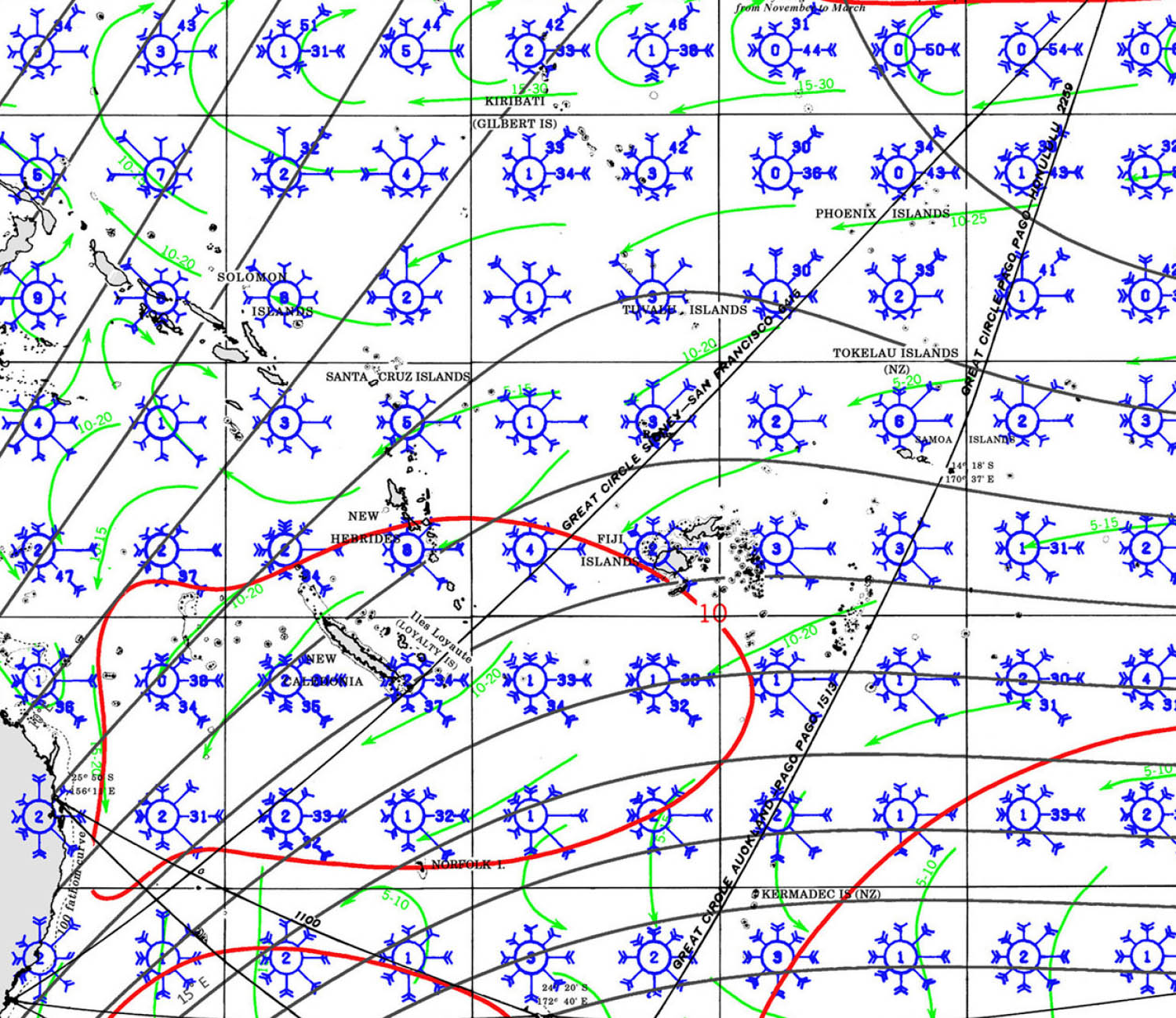
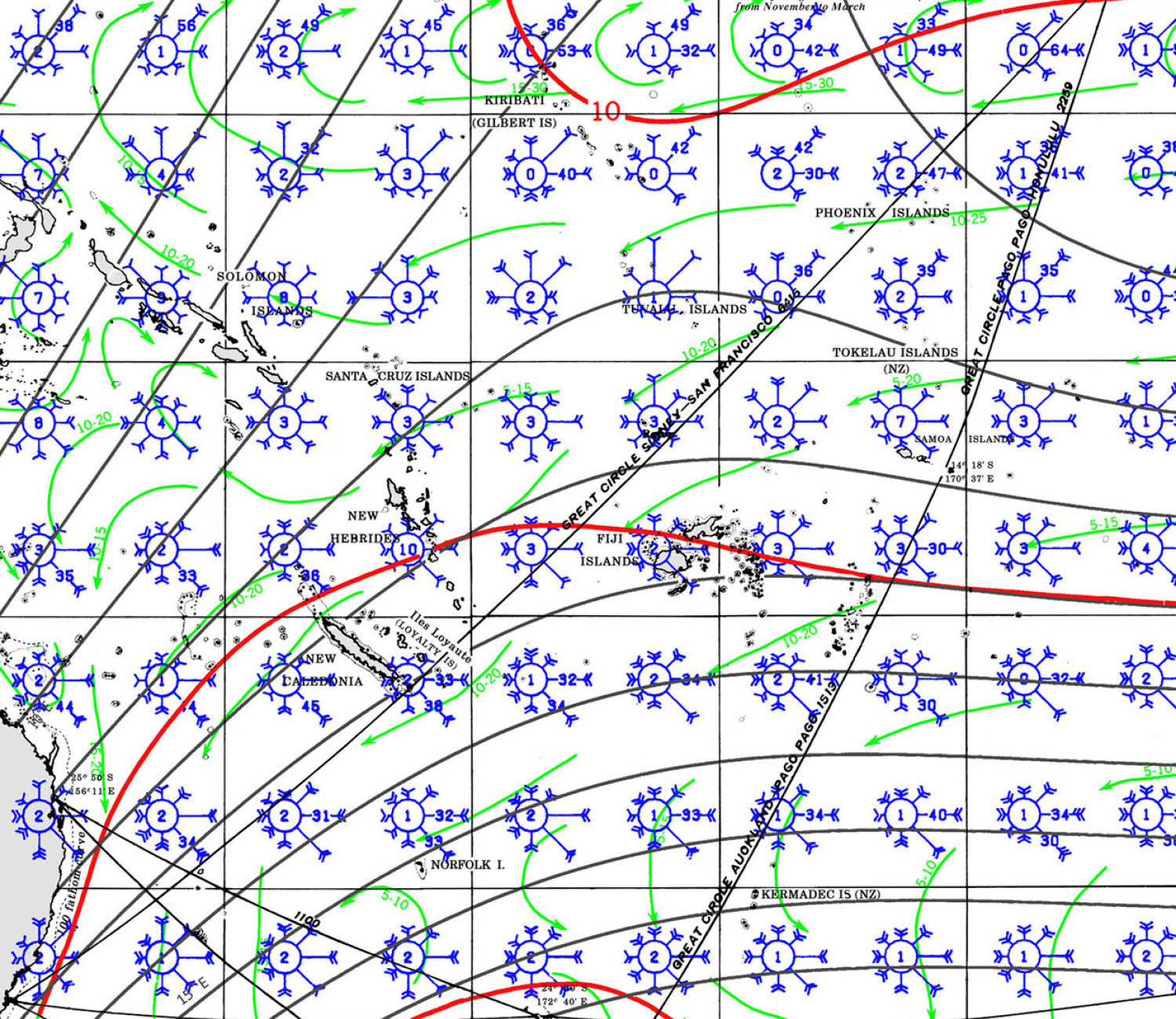
VANUATU Pilot Charts provide historic points and aggregated information of wind flows, air and ocean temperatures, wave heights, rain, barometric weight, and climate conditions at various seasons. This data was acquired from oceanographic and meteorologic perceptions over hundreds of years starting in the late eighteenth century. These diagrams are planned to help mariners choose routes around and approaching Cuba with respect to the normal climate and sea conditions using prevailing seasonal wind information.
PORTS OF ENTRY
It’s important to note that vessels must notify the Vanuatu Immigration Office before arriving at or departing from these designated ports of entry. The master of a vessel is required to provide a list of all officers, crew members, passengers (including those in transit), and other persons on board. Failure to comply with these requirements may result in fines or imprisonment.
For the most current information and specific entry requirements, it’s advisable to consult the Vanuatu Department of Immigration and Passport Services.
Vanuatu designates several official ports of entry for vessels arriving by sea and air. These ports are equipped to handle customs, immigration, and quarantine procedures.
Seaports:
- Lapeitasi Port: Located in Port Vila, Efate Island, it serves as the main maritime entry point.
- Niscol Port: Situated in Luganville on Espiritu Santo Island, catering to vessels in the northern areas.
- Lenakel Port: Found on Tanna Island, providing access to the southern regions.
- Mystery Port: Located on Aneityum Island, serving the southeastern part of Vanuatu.
- Litzlitz Port: Situated on Malekula Island, accommodating vessels to the central islands.
- Sola Port: Found on Vanualava Island, serving the northernmost areas.
Airports:
- Bauerfield International Airport (VLI): Located in Port Vila on Efate Island, this is the primary international gateway to Vanuatu.
- Pekoa International Airport (SON): Situated on Espiritu Santo Island, serving the northern regions.
- Whitegrass International Airport (TAH): Found on Tanna Island, accommodating flights to the southern parts of the archipelago.
DOCUMENTS
It’s important to note that vessels must notify the Vanuatu Immigration Office before arriving at or departing from these designated ports of entry. The master of a vessel is required to provide a list of all officers, crew members, passengers (including those in transit), and other persons on board. Failure to comply with these requirements may result in fines or imprisonment.
For the most current information and specific entry requirements, it’s advisable to consult the Vanuatu Department of Immigration and Passport Services.
Vanuatu designates several official ports of entry for vessels arriving by sea and air. These ports are equipped to handle customs, immigration, and quarantine procedures.
Seaports:
- Lapeitasi Port: Located in Port Vila, Efate Island, it serves as the main maritime entry point.
- Niscol Port: Situated in Luganville on Espiritu Santo Island, catering to vessels in the northern areas.
- Lenakel Port: Found on Tanna Island, providing access to the southern regions.
- Mystery Port: Located on Aneityum Island, serving the southeastern part of Vanuatu.
- Litzlitz Port: Situated on Malekula Island, accommodating vessels to the central islands.
- Sola Port: Found on Vanualava Island, serving the northernmost areas.
Airports:
- Bauerfield International Airport (VLI): Located in Port Vila on Efate Island, this is the primary international gateway to Vanuatu.
- Pekoa International Airport (SON): Situated on Espiritu Santo Island, serving the northern regions.
- Whitegrass International Airport (TAH): Found on Tanna Island, accommodating flights to the southern parts of the archipelago.
ENTRY EXIT REQUIREMENTS
| DOCUMENTATION | |
| Passport | Valid for at least _ months; requires one blank page |
| Boat Documentation | Coast Guard Doc (Original) |
| Insurance | |
| Crewlist | Required at checkin/out |
| Zarpe | Required at checkin/out |
| Fishing License | |
| Official Procedures | https://customsinlandrevenue.gov.vu/index.php/travellers/yacht-clearance |
| Official Country Visa | |
| Immigration Visa | |
| Required Permits | Proof of Covid Vaccination |
| Upon Arrival Visit: | Immigration; Customs; Port Captain/Authority |
| Upon Departure Visit: | Immigration; Customs; Port Captain |
| Total Entry & Exit Fees: | 5000 VAT biosecurity 4800 VAT Immigration 3000 VAT Rubbish |
MUST SEE
-
1. Mount Yasur Volcano (Tanna Island)
- Why Visit: One of the world’s most accessible active volcanoes with stunning eruptions visible even at night.
- Best Time: May to October (dry season for clear viewing).
2. Champagne Beach (Espiritu Santo Island)
- Why Visit: Famous for its powdery white sand and crystal-clear waters.
- Best Time: May to September (cooler and less humid).
3. Blue Holes (Espiritu Santo Island)
- Why Visit: Freshwater springs surrounded by lush jungle, ideal for swimming and snorkeling.
- Best Time: June to August (clear waters and comfortable temperatures).
4. Millennium Cave (Espiritu Santo Island)
- Why Visit: A thrilling adventure featuring hiking, river swimming, and exploring a massive limestone cave.
- Best Time: July to September (drier weather for hiking).
5. Port Vila Markets (Efate Island)
- Why Visit: Vibrant markets showcasing local produce, handicrafts, and traditional food.
- Best Time: Year-round, but May to October is cooler.
6. Eton Beach (Efate Island)
- Why Visit: A pristine, uncrowded beach with calm waters and beautiful scenery.
- Best Time: May to October.
7. The Rom Dance (Tanna Island)
- Why Visit: A traditional kastom ceremony featuring dramatic costumes and chants.
- Best Time: August to September (kastom festivals).
8. Naghol Land Diving (Pentecost Island)
- Why Visit: Witness the original bungee jumping ritual, an awe-inspiring display of bravery.
- Best Time: April to June (land diving season).
9. WW2 Wrecks (Espiritu Santo Island)
- Why Visit: Dive into history at sites like the SS President Coolidge and Million Dollar Point.
- Best Time: May to October (best diving conditions).
10. Mele Cascades (Efate Island)
- Why Visit: A series of cascading waterfalls surrounded by tropical rainforest.
- Best Time: May to September (cooler and less rainfall).
11. Hideaway Island and Marine Sanctuary (Efate Island)
- Why Visit: Snorkel the underwater post office and explore vibrant coral reefs.
- Best Time: July to October (calmer seas).
12. Siri Waterfall (Gaua Island)
- Why Visit: A majestic waterfall flowing into Lake Letas, surrounded by lush greenery.
- Best Time: June to September (dry season for easier trekking).
13. Ambrym Volcanoes (Ambrym Island)
- Why Visit: Trek to the twin active volcanoes, Benbow and Marum, with views of glowing lava lakes.
- Best Time: August to October (dry season).
14. Cultural Village Tours (Efate and Malekula Islands)
- Why Visit: Experience traditional Vanuatu kastom, dances, and storytelling.
- Best Time: Year-round.
15. Fele Museum (Port Vila, Efate Island)
- Why Visit: Learn about Vanuatu’s rich history, culture, and artifacts.
- Best Time: Year-round.
16. The Banks Islands
- Why Visit: Remote and unspoiled, perfect for experiencing untouched Vanuatu culture and nature.
- Best Time: June to October (calm seas for sailing).
17. Shark Bay (Malekula Island)
- Why Visit: Explore mangroves, dive sites, and the chance to encounter reef sharks.
- Best Time: June to August.
18. Aneityum Island
- Why Visit: Home to Mystery Island, a tiny uninhabited islet with stunning beaches and reefs.
- Best Time: April to October.
19. Vanuatu Rainforest Zipline (Efate Island)
- Why Visit: Thrilling canopy ziplining with panoramic views of the rainforest and Mele Bay.
- Best Time: July to September.
20. Lake Letas (Gaua Island)
- Why Visit: A pristine volcanic lake surrounded by lush greenery, perfect for canoeing and exploring.
- Best Time: May to August.

REPAIRS AND SERVICE PROVIDERS
Vanuatu offers a limited range of yacht service providers to cater to the needs of visiting vessels. Here are some notable options:
Vanuatu’s Full Service Marine Repair & Storage Facility
Port Vila Boatyard
Ifira Point, Vila, Vanuatu
Port of Call Vanuatu
Provides professional services including yacht cruising information, clearances, provisions, cruising permits, and tour organization.
Vanuatu Yacht Services
Offers exclusive yacht agency services, including yacht clearance formalities, charter planning assistance, duty-free bunkering, outer island support, provisioning, and technical services.
Yachting World Marina
EMERGENCIES AND SAR INFO
NEW CALEDONIA HANDLES VANUATU SAR

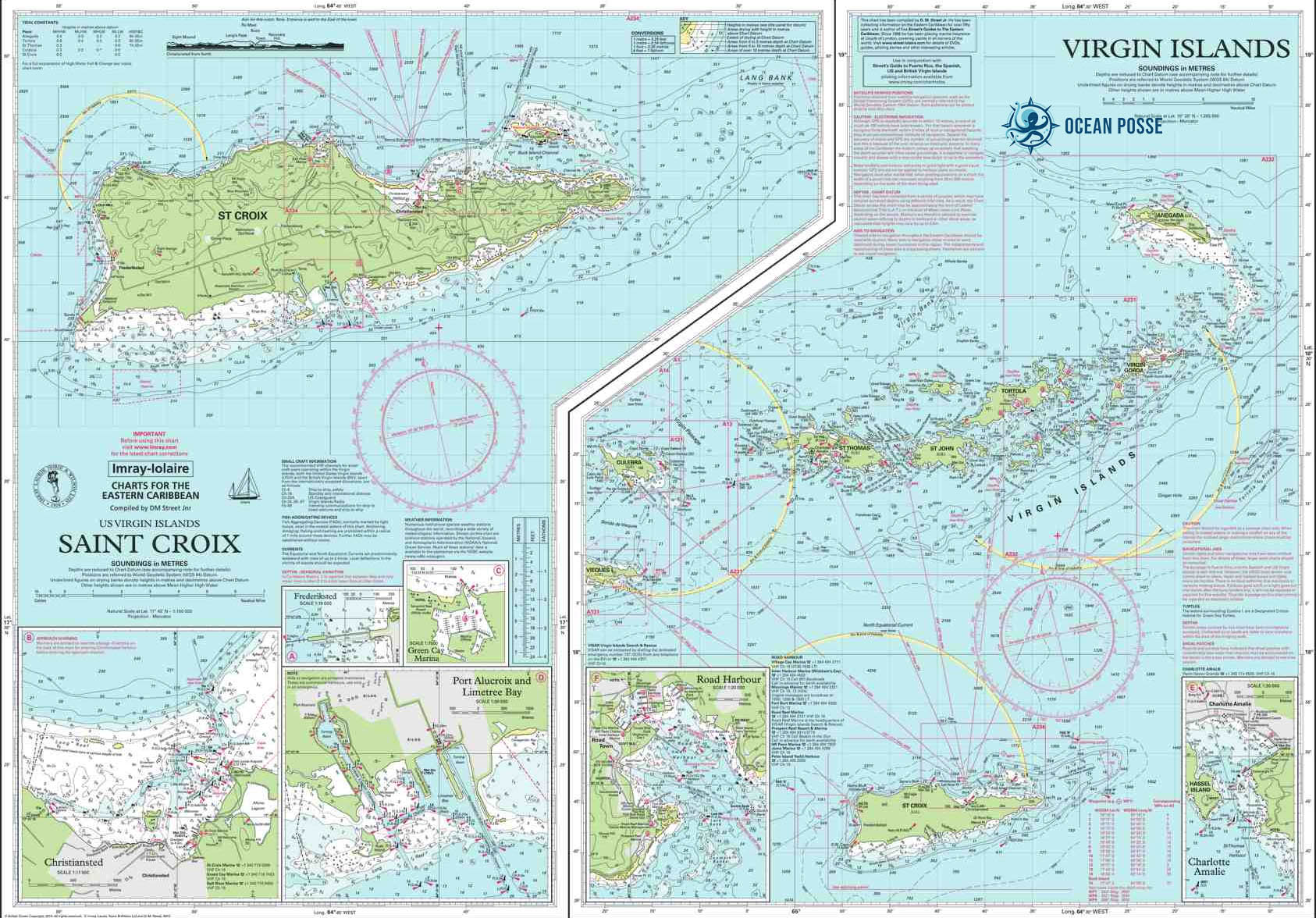
VIRGIN GORDA YACHT HARBOUR 🇻🇬 SPONSORS THE OCEAN POSSE
VIRGIN GORDA YACHT HARBOUR 🇻🇬 SPONSORS THE OCEAN POSSE
18° 26.9633′ N 064° 26.2316′ W

Sail into a world of luxury and exceptional service at Virgin Gorda Yacht Harbour marina. Our haven is meticulously designed to surpass your expectations, offering cutting-edge facilities tailored for vessels of all sizes. Experience the seamless blend of sophistication and functionality as you anchor in a sanctuary that redefines nautical excellence.
Discounts at VIRGIN GORDA YACHT HARBOUR for participating OCEAN POSSE VESSELS
We will offer a 15% discount for normal rates at our Marina docking fees for the Members of the Community.
We will offer a 15% discount on lay day rates for boatyard stays (for repairs or works on our facility).
This discount is not valid with other discounts or offers we may have.
Availability to this sponsorship is subject to reservation and space.

AMENITIES
- Recently renovated bathrooms and shower rooms
- Chandlery
- Fuel Dock
- Pump-out waste disposal
- Laundry
- Fitness Center
- Dive BVI diving and boat trips
- Spa
- Fitness Center
- Island tours via taxi drivers
- Concierge service
- Complimentary WiFi throughout the yacht harbour
CONTACT
- Alejandro Chometowski
- General Manager
- VIRGIN GORDA YACHT HARBOUR
- P.O. Box 1005,Virgin Gorda, British Virgin Islands. VG 1150
- T: (284) 499-5500
- M: (284) 499-5577
- www.vgyh.vg
SAVE APPROACH
LOCATION
OFFICIAL WEBSITE


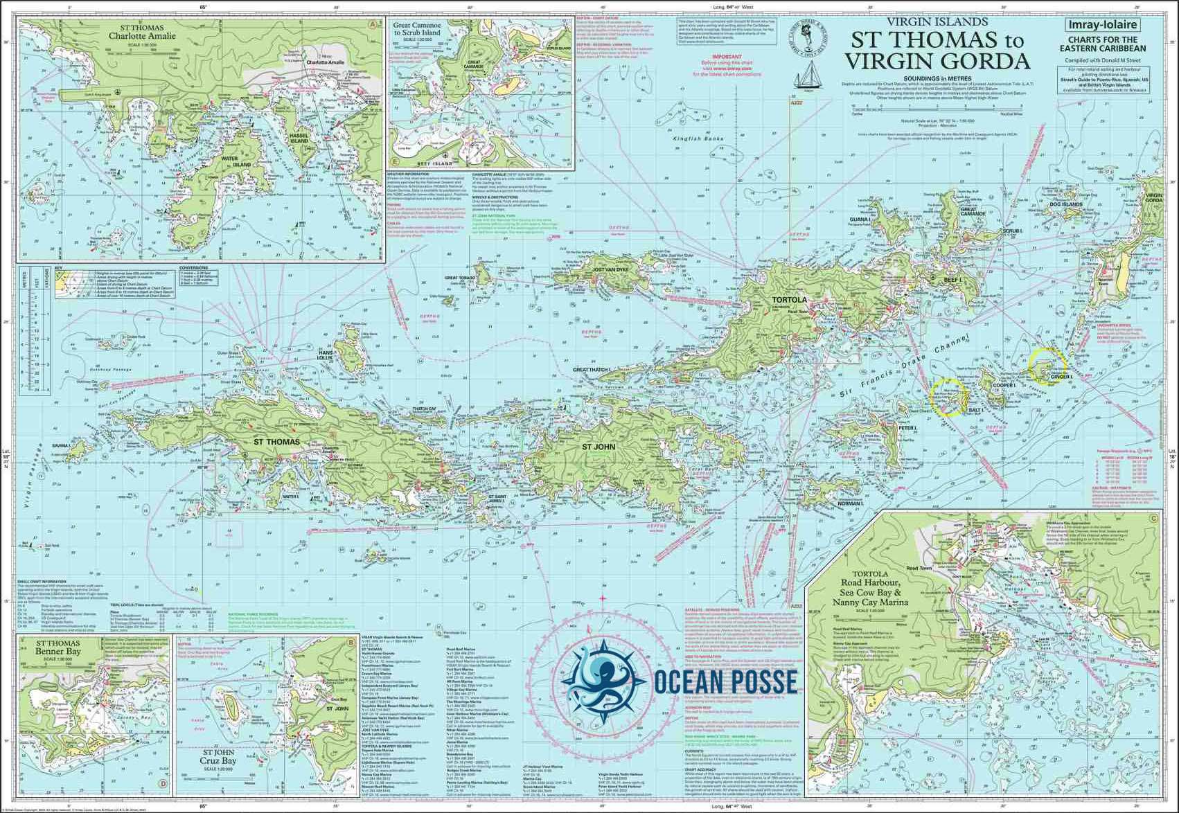
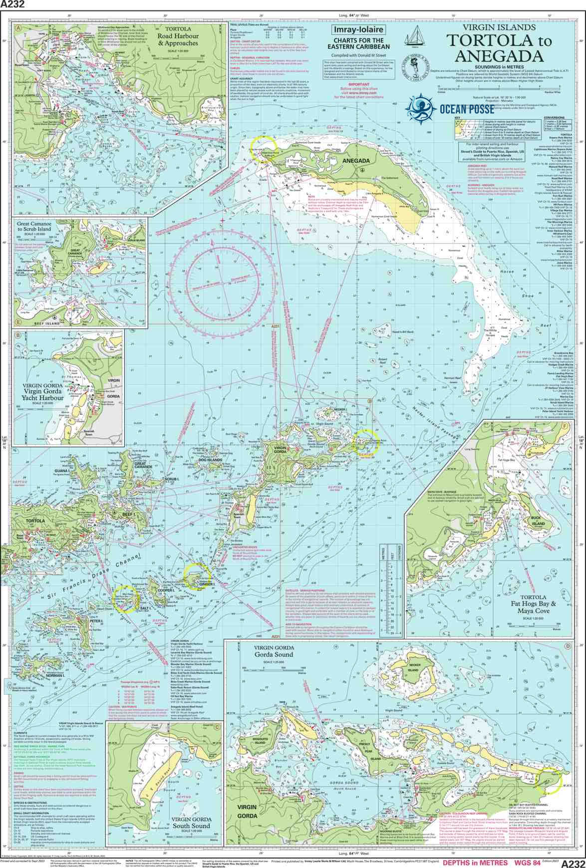
BRITISH VIRGIN ISLANDS 🇻🇬 Cruising the BVI's with the Ocean Posse

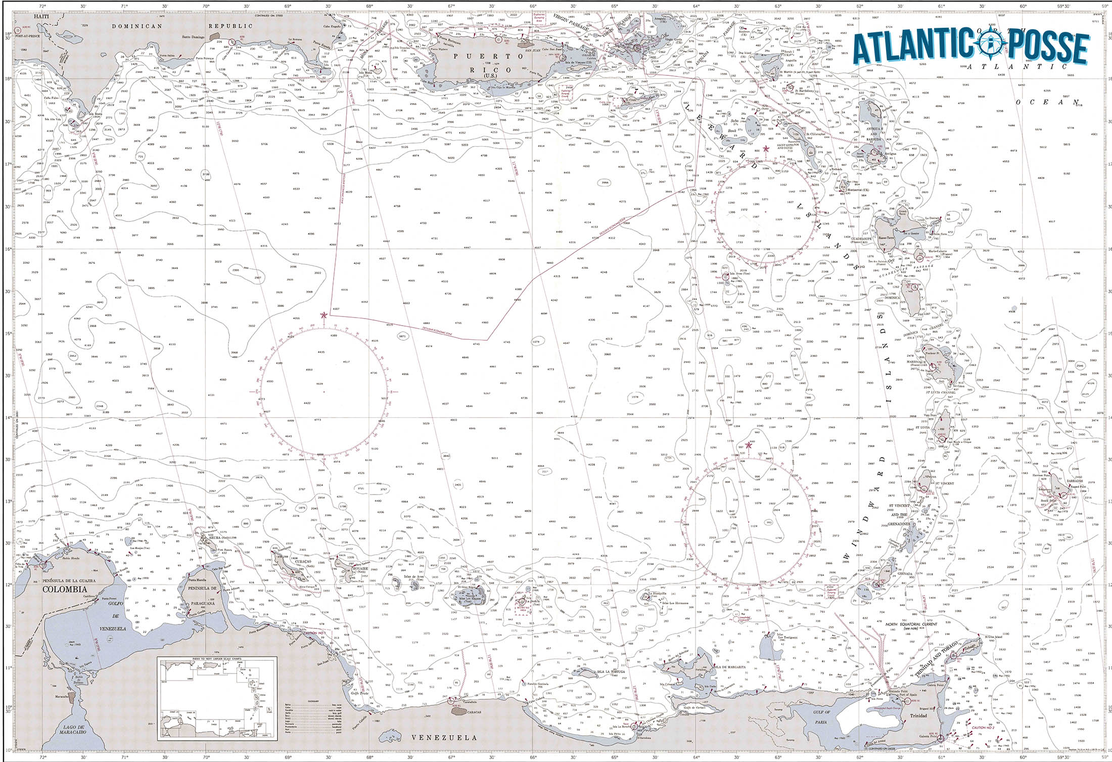
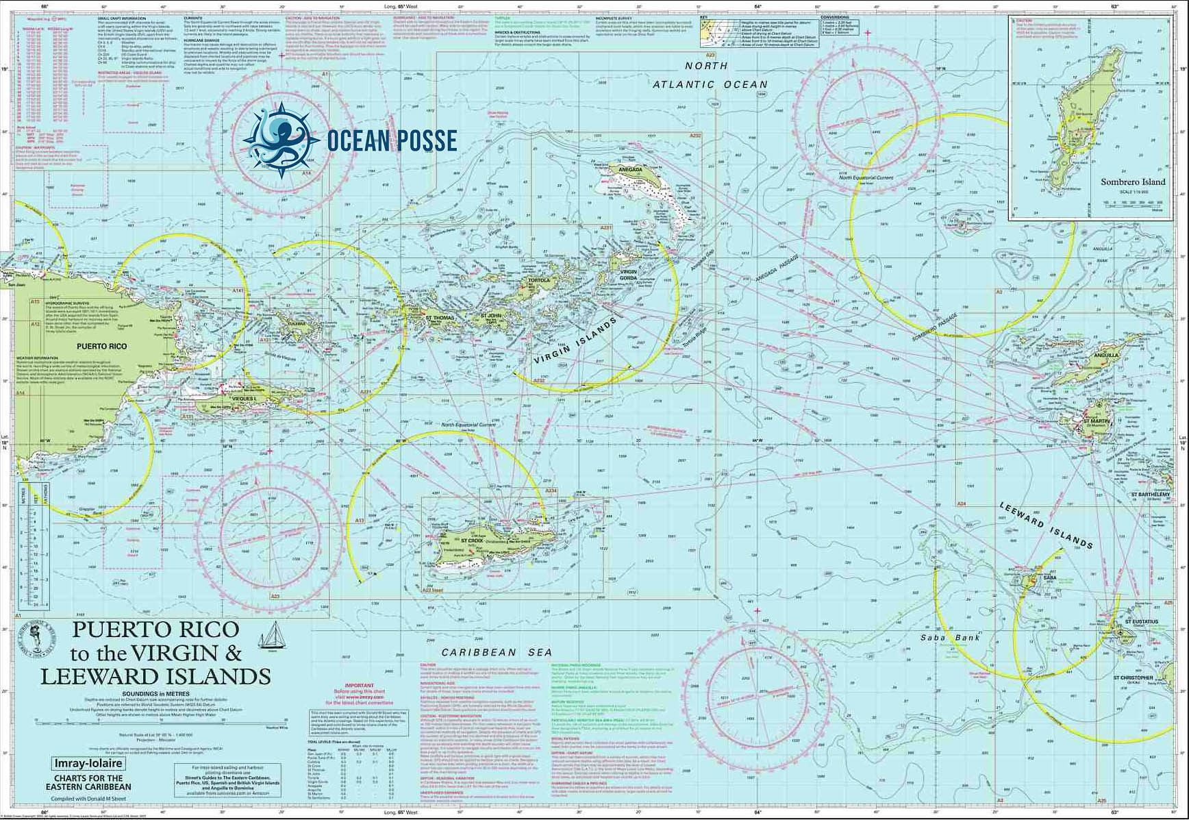
1. Introduction to the British Virgin Islands (BVI)
- Setting the Scene: A brief on the allure of the BVIs, including unique geography, the steady trade winds, and a welcoming maritime culture.
- Ideal for Yachts: Why the BVIs stand out as a destination for experienced cruisers who own their yachts, emphasizing exploration beyond the main charter routes.
2. Navigational Insights for Yacht Owners
- Key Ports and Anchorages: Dive into top ports like Road Town, Soper’s Hole, and the Yacht Harbour at Virgin Gorda, detailing mooring availability, facilities, and local contacts.
- Weather Patterns and Seasons: Discuss seasonal wind variations, hurricane season, and tips on safe anchoring and navigating currents for those familiar with their own yachts.
- Regulations: Outline customs, immigration processes, and cruising permits for yacht owners.
3. Iconic Destinations and Hidden Gems
- Main Attractions: Describe famed spots like The Baths, Anegada’s beaches, and Norman Island’s caves. Include tips on where to dock or anchor and nearby services.
- Off-the-Beaten-Path: Highlight lesser-known spots, like Diamond Cay, Salt Island, and Monkey Point, which are often bypassed by charter companies.
4. Cruising Culture in the BVIs
- Connecting with Other Yacht Owners: Tips on where to meet fellow cruisers, such as local yacht clubs, waterfront cafes, and marinas known for friendly communities.
- Supporting Local Businesses: Insights on recommended local eateries, marine supply stores, and boat maintenance services that support independent yacht owners.
5. Practical Tips for Longer Stays
- Provisioning and Refueling: Locations for groceries, refueling, and fresh water access; tips for extended voyages, including popular spots for local produce.
- Marine Services: Information on the best spots for repairs, dive services, and yacht detailing.
- Staying Connected: Options for WiFi and cell coverage, plus where cruisers can expect to find quiet spots with minimal connectivity for true seclusion.
6. Environmental Responsibility and Community Initiatives
- Sustainable Sailing: Encourage practices like mindful anchoring and minimizing waste. Tips on where to dispose of waste responsibly in the BVIs.
- Conservation and Volunteering: Outline any ongoing efforts, such as coral restoration and beach clean-ups, where yacht owners can contribute.
7. Seasonal Events and Local Festivities
- Sailing Events: Feature local regattas or festivals, such as the BVI Spring Regatta, and what yacht owners can expect during these times.
- Local Celebrations: Share notable cultural events in the BVIs that give a deeper connection to the area and its people.
This outline ensures coverage of essential details, from practical insights to unique, immersive experiences that resonate with seasoned yacht owners looking to savor the BVIs at their own pace.
MARINAS
🇻🇬 BRITISH VIRGIN ISLANDS
Tortola:
- Nanny Cay Marina: Located between Road Town and West End, Nanny Cay offers 180 berths, a boatyard, hotel accommodations, restaurants, and various marine services.
- Phone: +1 284-394-2512
- Email: info@nannycay.com
- Website: nannycay.com
- Village Cay Marina: Situated in Road Town, this marina provides 106 slips for vessels up to 190 feet, along with amenities like a hotel, restaurant, pool, and provisioning options.
- Phone: +1 284-494-2771
- Email: info@villagecaybvi.com
- Website: villagecaybvi.com
- Soper’s Hole Wharf & Marina: Found on the western side of Tortola at Frenchman’s Cay, Soper’s Hole features 43 slips, 18 moorings, dining, shopping, and other facilities.
- Phone: +1 284-495-4589
- Email: info@sopersholemarina.com
- Website: sopersholemarina.com
- Hodges Creek Marina: Located in Maya Cove, this marina offers docking facilities and serves as a base for several charter companies.
- Phone: +1 284-494-5000
- Email: info@hodgescreek.com
- Website: hodgescreek.com
- Penn’s Landing Marina: A tranquil, private marina in Fat Hog’s Bay, East End, providing a range of yacht and boat services year-round.
- Phone: +1 284-495-1134
- Email: pennslandingbvi@gmail.com
- Website: pennslandingbvi.com
- Road Reef Marina: Positioned in Road Town, offering docking facilities and marine services.
- Phone: +1 284-494-2600
- Email: info@roadreefmarina.com
- Website: roadreefmarina.com
- Fort Burt Marina: Also in Road Town, providing docking and related amenities.
- Phone: +1 284-494-4200
- Email: info@fortburt.com
- Website: fortburt.com
Virgin Gorda:
- Virgin Gorda Yacht Harbour: Located in Spanish Town, this marina offers docking facilities, a boatyard, shopping, and dining options.
- Phone: +1 284-495-5500
- Email: info@vgyh.vg
- Website: vgyh.vg
- Leverick Bay Resort and Marina: Situated in North Sound, Leverick Bay provides slips, moorings, fuel, water, and resort amenities.
- Phone: +1 284-495-7421
- Email: leverickbay@leverickbay.com
- Website: leverickbayvg.com
- Bitter End Yacht Club: Located in North Sound, offering docking facilities and resort services.
- Phone: +1 312-506-6205
- Email: info@beyc.com
- Website: beyc.com
- Saba Rock Resort: A small island resort in North Sound with docking facilities for guests.
- Phone: +1 284-393-9220
- Email: info@sabarock.com
- Website: sabarock.com
Scrub Island:
- Scrub Island Resort, Spa & Marina: This private island resort offers a 55-slip marina accommodating vessels up to 170 feet, along with luxury resort amenities.
- Phone: +1 284-394-3440
- Email: info@scrubisland.com
- Website: scrubisland.com
Peter Island:
- Peter Island Resort & Yacht Harbour: Located on Peter Island, offering docking facilities and resort services.
- Phone: +1 284-495-2000
- Email: info@peterisland.net
- Website: peterisland.com
Anegada:
- Anegada Reef Hotel Marina: Provides limited docking facilities primarily for guests of the hotel.
- Phone: +1 284-495-8002
- Email: info@anegadareef.com
- Website: anegadareef.com
WEATHER
WIND
SWELL WAVE
PILOT CHARTS
BRITISH VIRGIN ISLANDS Pilot Charts provide historic points and aggregated information of wind flows, air and ocean temperatures, wave heights, rain, barometric weight, and climate conditions at various seasons. This data was acquired from oceanographic and meteorologic perceptions over hundreds of years starting in the late eighteenth century. These diagrams are planned to help mariners choose routes around and approaching Cuba with respect to the normal climate and sea conditions using prevailing seasonal wind information.
PORTS OF ENTRY
🇻🇬 BRITISH VIRGIN ISLANDS
DOCUMENTS
MUST SEE
1. The Baths, Virgin Gorda
- Why Visit: A geological wonder with massive granite boulders forming natural pools, caves, and grottos.
- Best Time: Early morning in winter (November–March) to avoid crowds and enjoy cooler weather.
2. Gorda Peak National Park
- Why Visit: Offers panoramic views of the islands and is home to diverse flora and fauna.
- Best Time: December–April for clear skies and ideal hiking conditions.
3. Anegada Island
- Why Visit: Known for secluded beaches, salt ponds, and the Caribbean’s best lobster.
- Best Time: November–April to avoid intense summer heat.
4. Cane Garden Bay, Tortola
- Why Visit: Pristine beach with clear waters, lively beach bars, and local restaurants.
- Best Time: December–March for the most vibrant beach scene.
5. Jost Van Dyke’s White Bay
- Why Visit: A beautiful beach with crystal waters, famous for its beach bars, including the Soggy Dollar Bar.
- Best Time: November–April, especially around New Year’s for Foxy’s Old Year’s Night party.
6. Norman Island
- Why Visit: Known for excellent snorkeling, especially at the Caves and the Indians.
- Best Time: May and October for fewer crowds and calm waters.
7. Rhone National Marine Park
- Why Visit: Explore the wreck of the RMS Rhone, one of the most famous Caribbean dive sites.
- Best Time: Year-round for diving, with November–April offering the best conditions.
8. Sandy Cay
- Why Visit: Tiny island with a lush interior, hiking trails, and untouched beaches.
- Best Time: December–April to avoid high temperatures.
9. Smuggler’s Cove, Tortola
- Why Visit: Secluded and beautiful, it’s a favorite for snorkeling and beach lounging.
- Best Time: Early morning in December–March for peace and quiet.
10. Cooper Island
- Why Visit: Known for its eco-resort, good snorkeling, and vibrant coral reefs.
- Best Time: November–April for ideal weather and water conditions.
11. Foxy’s Tamarind Bar, Jost Van Dyke
- Why Visit: A legendary spot with live music and great Caribbean vibes.
- Best Time: December–March, with New Year’s being a particularly festive time.
12. Bubbly Pool, Jost Van Dyke
- Why Visit: A natural “jacuzzi” formed by waves rushing through rocks.
- Best Time: Visit between November–April when seas are calmer, for safer exploring.
13. Peter Island
- Why Visit: Pristine beaches and excellent snorkeling, especially Deadman’s Bay.
- Best Time: December–April for the best beach conditions.
14. Saba Rock
- Why Visit: Small island resort known for dining, drinks, and a relaxed atmosphere.
- Best Time: Year-round, but more festive in winter months (November–April).
15. Great Harbour, Jost Van Dyke
- Why Visit: Anchoring spot for those visiting local bars and exploring the island.
- Best Time: December–March, when the harbor is lively yet not overly crowded.
16. Long Bay Beach, Tortola
- Why Visit: Beautiful stretch of sand with fewer crowds, perfect for beach walks.
- Best Time: Morning hours in November–April.
17. Spanish Town, Virgin Gorda
- Why Visit: A quaint town with shops, restaurants, and a historic copper mine.
- Best Time: Year-round, but more vibrant December–April.
18. Scrub Island
- Why Visit: Known for luxury resorts, excellent snorkeling, and pristine beaches.
- Best Time: December–April to enjoy the best resort experience.
19. Anegada’s Horseshoe Reef
- Why Visit: Largest coral reef in the Caribbean and a paradise for divers.
- Best Time: February–April for calm seas and good visibility.
20. Little Harbour, Jost Van Dyke
- Why Visit: A peaceful bay with excellent dining, including fresh seafood.
- Best Time: November–April for ideal dining and relaxation conditions.
21. Mount Sage National Park
- Why Visit: Highest peak in the BVIs, offering incredible hiking trails.
- Best Time: November–April for cool temperatures.
22. Salt Island
- Why Visit: Known for salt ponds and the wreck of the RMS Rhone.
- Best Time: November–April for historical exploration and diving.
23. Marina Cay
- Why Visit: Small island with calm waters, ideal for a peaceful retreat.
- Best Time: Year-round, though busiest from December to March.
24. Belmont Bay, Tortola
- Why Visit: Remote bay with beautiful waters and scenic views.
- Best Time: Late spring (April–May) or early fall (September–October) for solitude.
REPAIRS AND SERVICE PROVIDERS
1. B&G Marine Services
- Location: Nanny Cay Marina, Tortola
- Services: Yacht management, mechanical and electrical repairs, metal fabrication, shipwright services, and refits.
- Phone: +1 284-345-2656
- Email: ted.reshetiloff@bgbvi.com
- Website: bgbvi.com
2. Marine Maintenance Services BVI Ltd.
- Location: Road Town, Tortola
- Services: Main engine and generator replacement, air conditioning installations, refrigeration and watermaker repairs, electrical services, and hydraulic press system operations.
- Phone: +1 284-494-3494
- Email: Contact via website
- Website: superyachtservicesguide.com
3. Aquadoc
- Location: Nanny Cay Marina, Tortola
- Services: Authorized service agent and dealer for Fischer Panda generators and Spectra Watermakers; certified Kohler Generator repair facility; electrical works, refrigeration and air conditioning, inboard and outboard motor maintenance.
- Phone: +1 284-346-7643
- Email: aquadocmarine@surfbvi.com
- Website: superyachtservicesguide.com
4. A&J Marine
- Location: Virgin Gorda
- Services: Yacht maintenance, management, charter vacation itinerary planning, guest services, and BVI maritime compliance assistance.
- Phone: +1 284-541-6861
- Email: info@aandjmarine.com
- Website: aandjmarine.com
5. Pitt Marine
- Location: Leverick Bay Marina, Virgin Gorda
- Services: Chandlery, marine supplies, yacht services, dockside support, project management, and maintenance support.
- Phone: +1 284-547-3636
- Email: Contact via website
- Website: pittmarine.com
6. SS Marine
- Location: West End, Tortola
- Services: Boat maintenance, yacht management, repair work, spare parts, and small-scale salvage work.
- Phone: Contact via website
- Email: Contact via website
- Website: ss-marine.net
EMERGENCIES AND SAR INFO

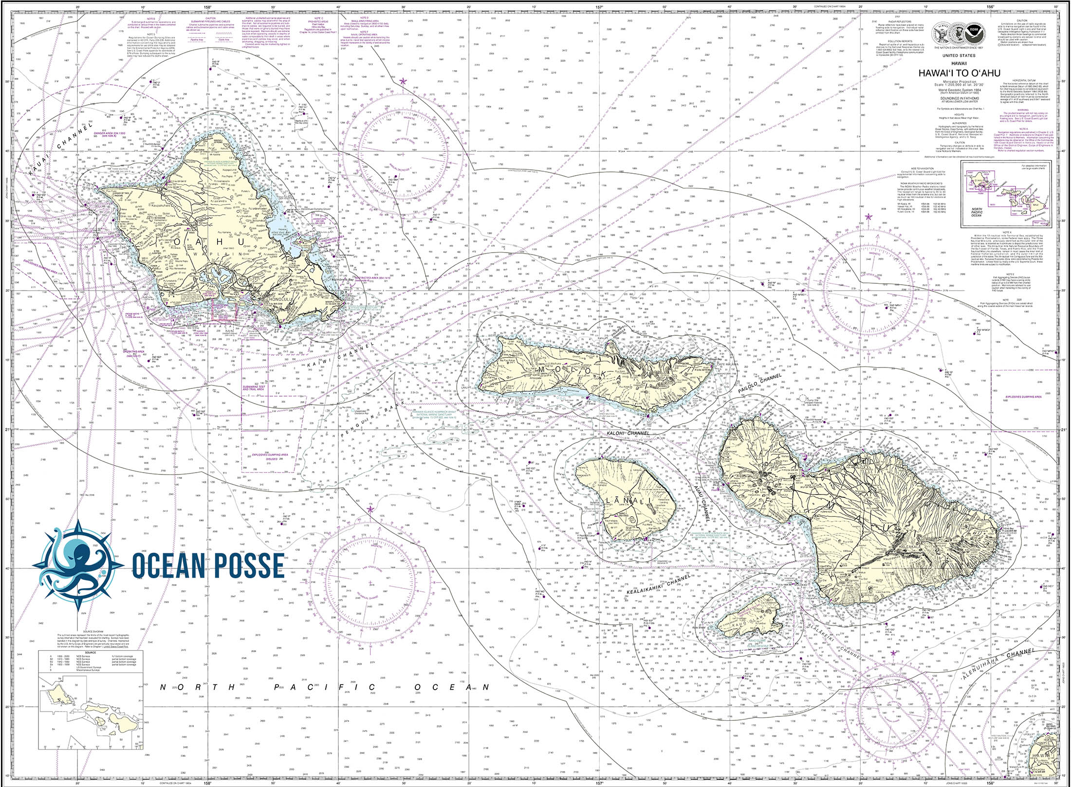
HAWAI'I
 HAWAI’I
Hawai’i, an island group in the north Pacific Ocean, offers private yacht cruisers an unparalleled adventure filled with breathtaking landscapes, rich cultural heritage, and diverse marine ecosystems. cruising these islands presents unique challenges that require planning, extensive local knowledge, and respect for both natural and cultural resources.
Challenges for Yachting in Hawai’i
- Remote Location: Hawai’i’s isolation in the Pacific presents logistical challenges, such as fuel and provisioning. Many supplies must be brought in, and some parts may be hard / expensive or will take a longer time to come by.
- Weather Patterns: The islands’ weather is characterized by trade winds, sudden squalls, and hurricane risks during certain times of the year.
- Navigational Hazards: Strong currents, submerged reefs, and rapidly shifting wind conditions can pose serious dangers. The channels between islands are known for being particularly rough.
- Permitting and Regulations: Cruisers must navigate a complex set of rules regarding anchoring, protected areas, and environmental conservation laws.
- Cultural Sensitivity: The islands are home to sacred sites and traditional fishing grounds. Respecting the cultural significance of these areas is crucial.
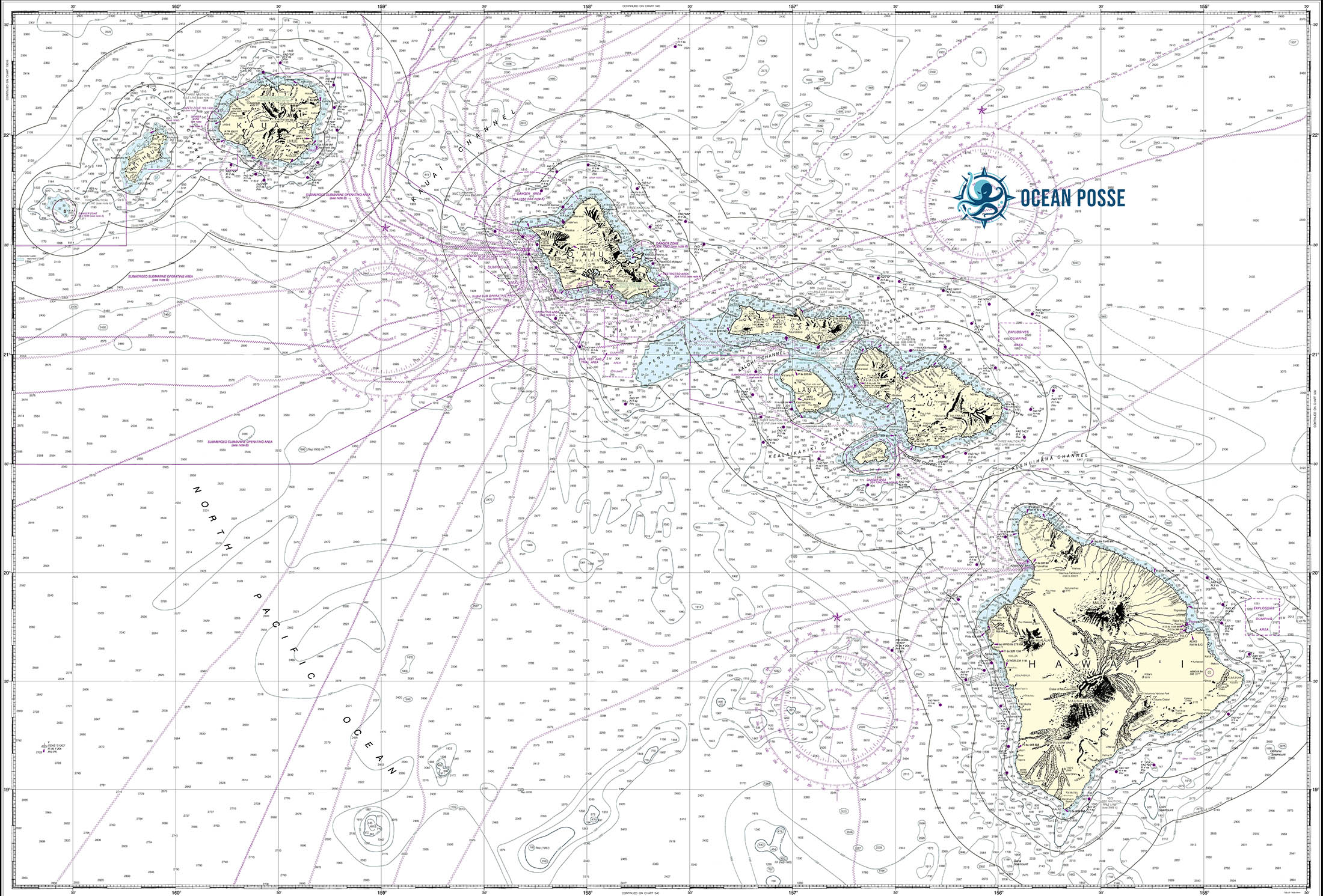
The Hawaiian Islands
-
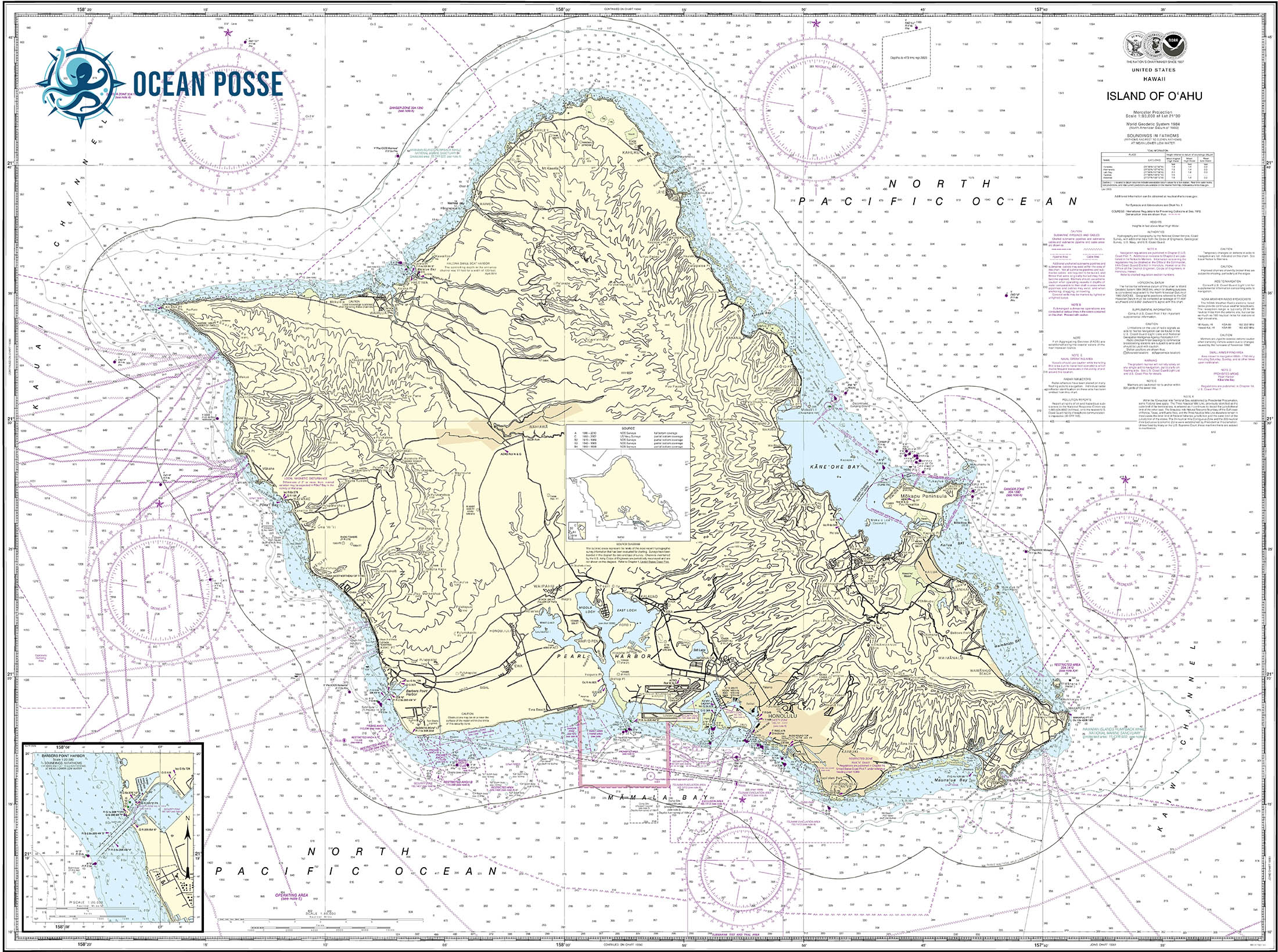
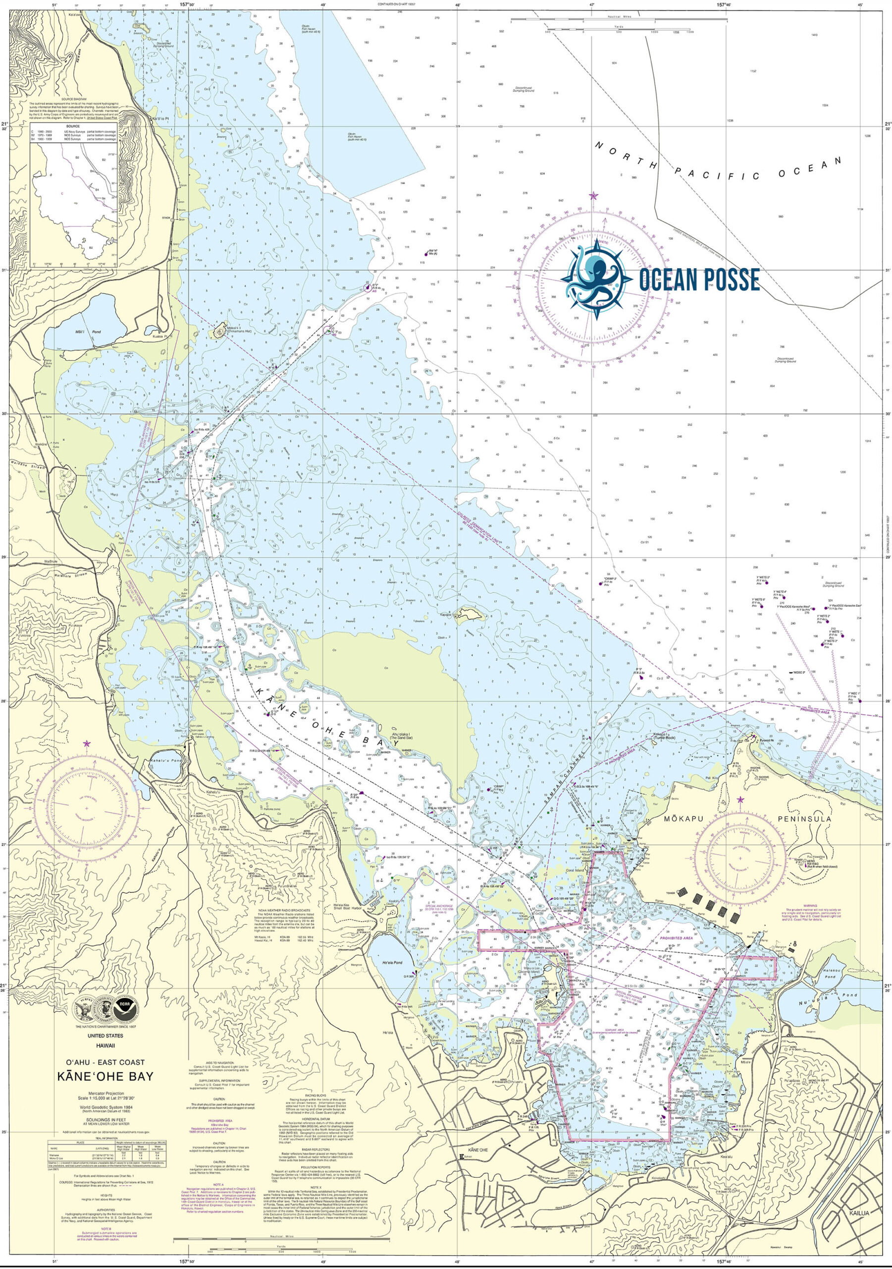
Oʻahu: The Gathering Place
- Overview: Known for its vibrant city life, famous beaches, and historic sites.
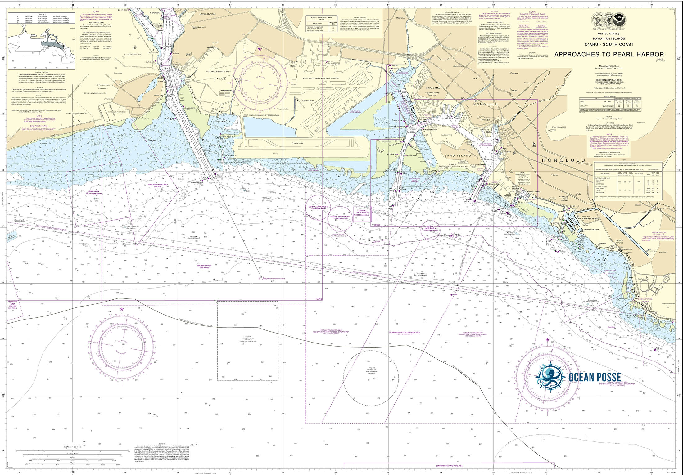
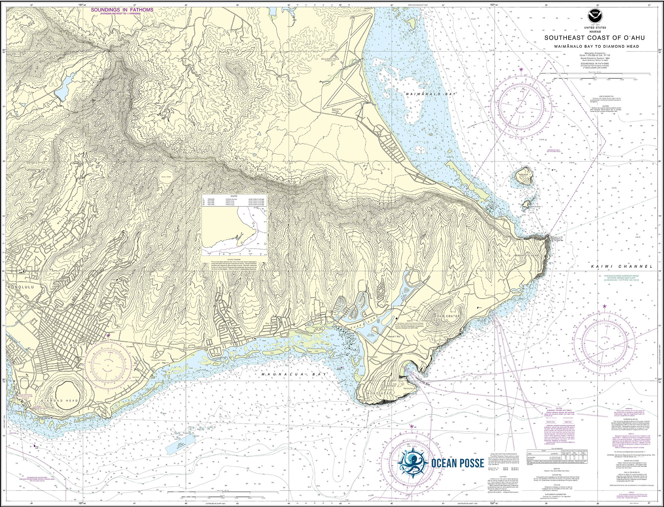
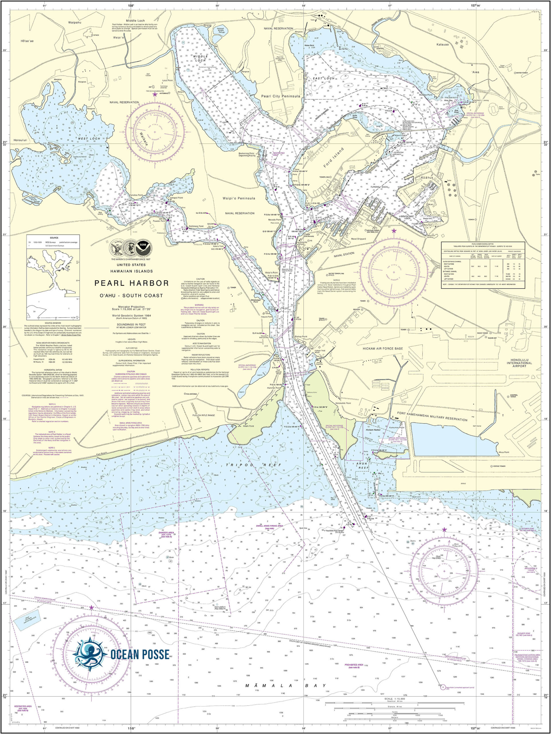
- Routes & Anchorages: Popular stops include Honolulu Harbor and Kane’ohe Bay. Pearl Harbor and Waikīkī are must-visit locations, but mariners need to be mindful of the heavy marine traffic and strict regulations.
- Challenges: Navigating the bustling waters around Honolulu and dealing with frequent afternoon trade winds.
- Local Tips: Best to plan early morning departures to avoid strong afternoon winds.
-
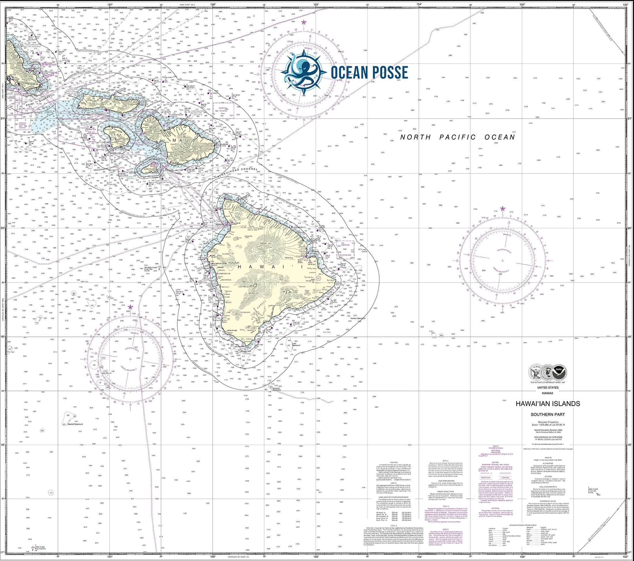
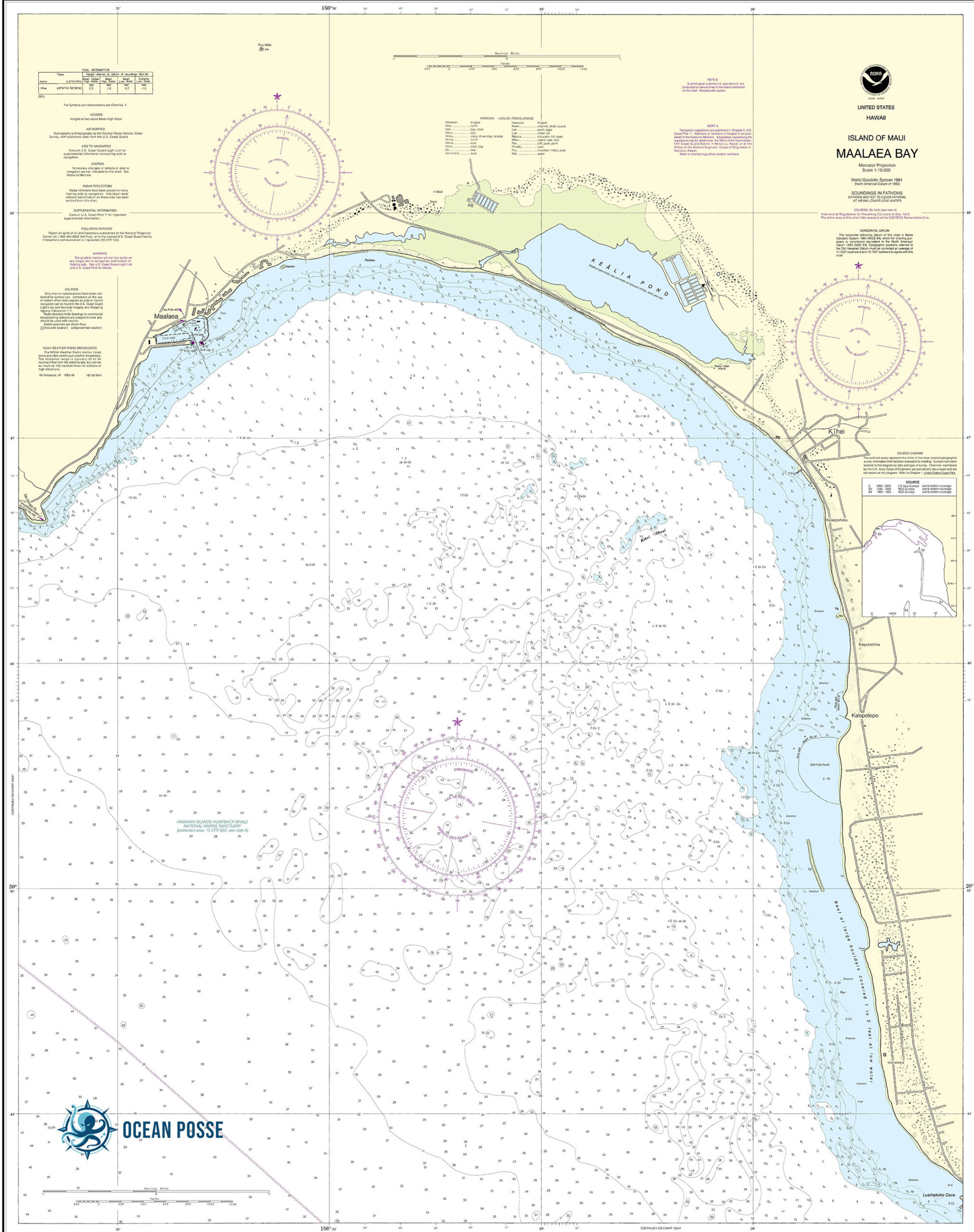
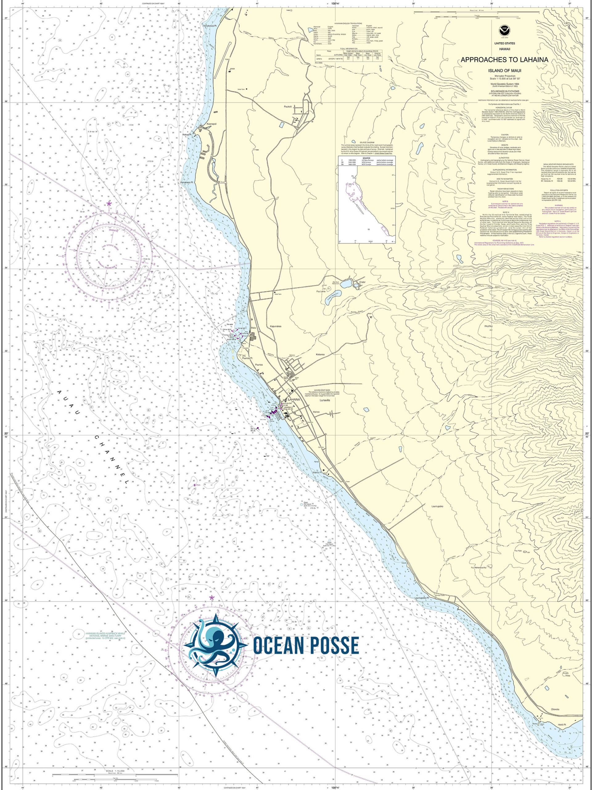
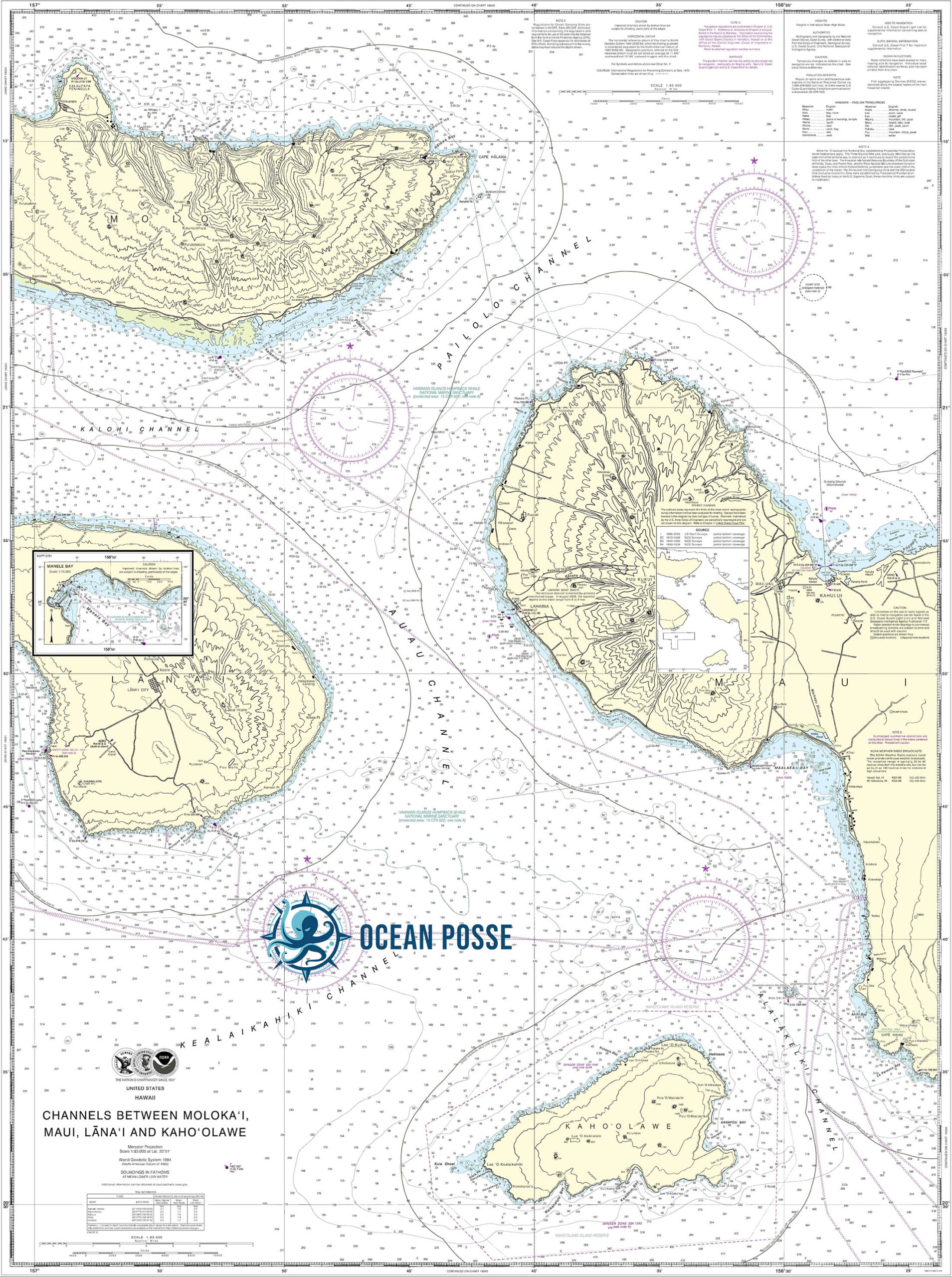
Maui: The Valley Isle
- Overview: Maui offers stunning coastlines, the famous Road to Hana, and world-class snorkeling spots like Molokini Crater.
- Routes & Anchorages: Lahaina Harbor and Maʻalaea Bay are key spots, but swells can make anchoring tricky.
- Challenges: The Pailolo Channel between Maui and Moloka’i is notoriously rough, earning its nickname “the crazy fisherman.”
- Local Tips: Be aware of marine protected areas and use caution around the powerful currents.
-
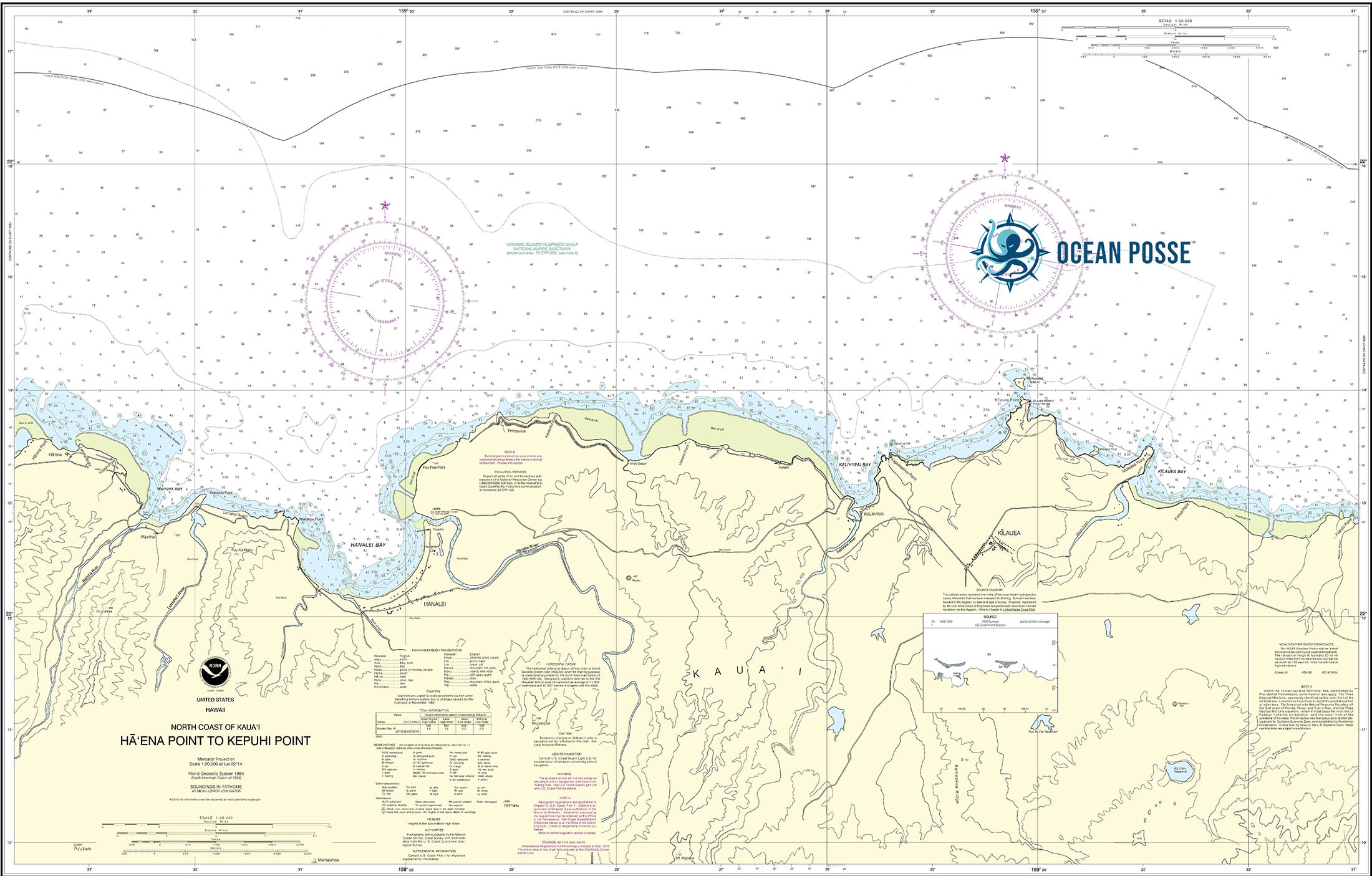
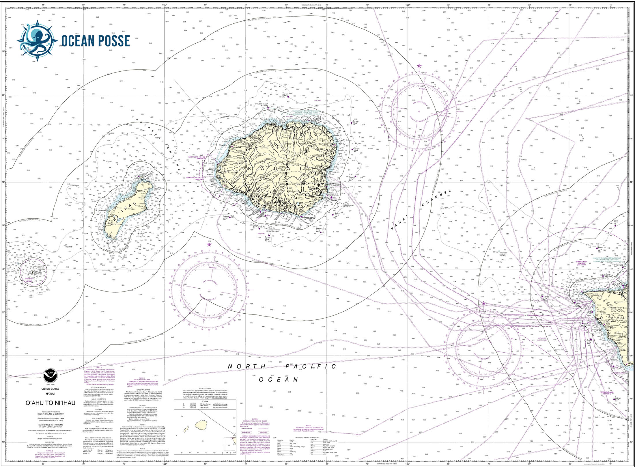
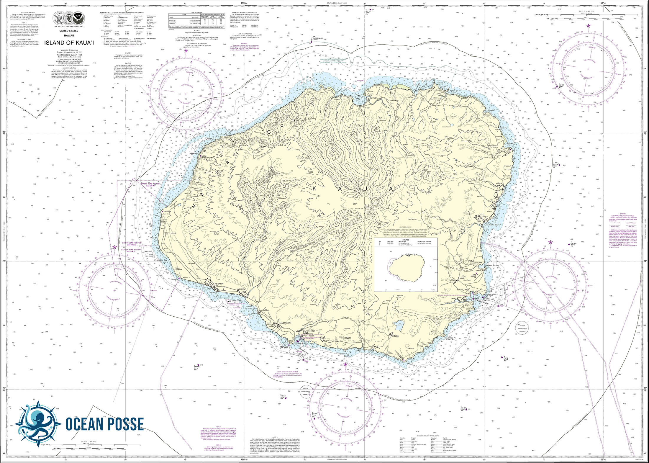
Kauaʻi: The Garden Isle
- Overview: Renowned for its lush landscapes, dramatic cliffs of the Nā Pali Coast, and serene beaches.
- Routes & Anchorages: Hanalei Bay offers a picturesque anchorage. However, weather conditions can change rapidly, and the Nā Pali Coast has limited safe harbor options.
- Challenges: Sudden squalls and remote anchorages require a high level of self-sufficiency.
- Local Tips: Prepare for frequent rainfall and stock up before heading to remote areas.
-
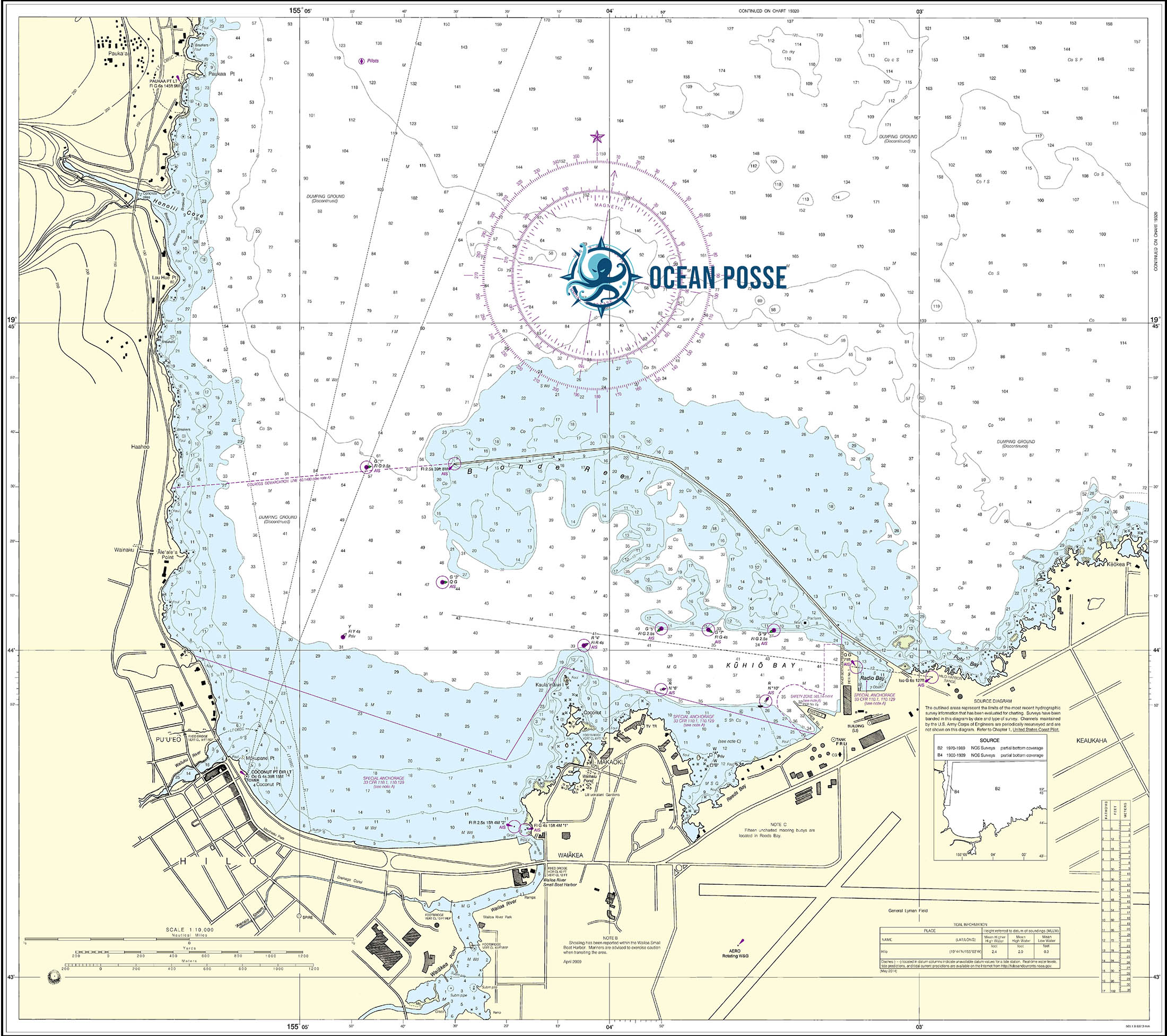
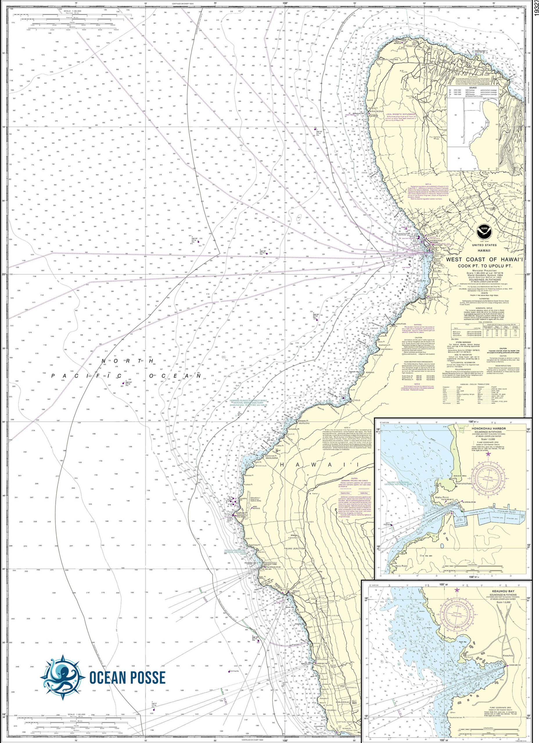
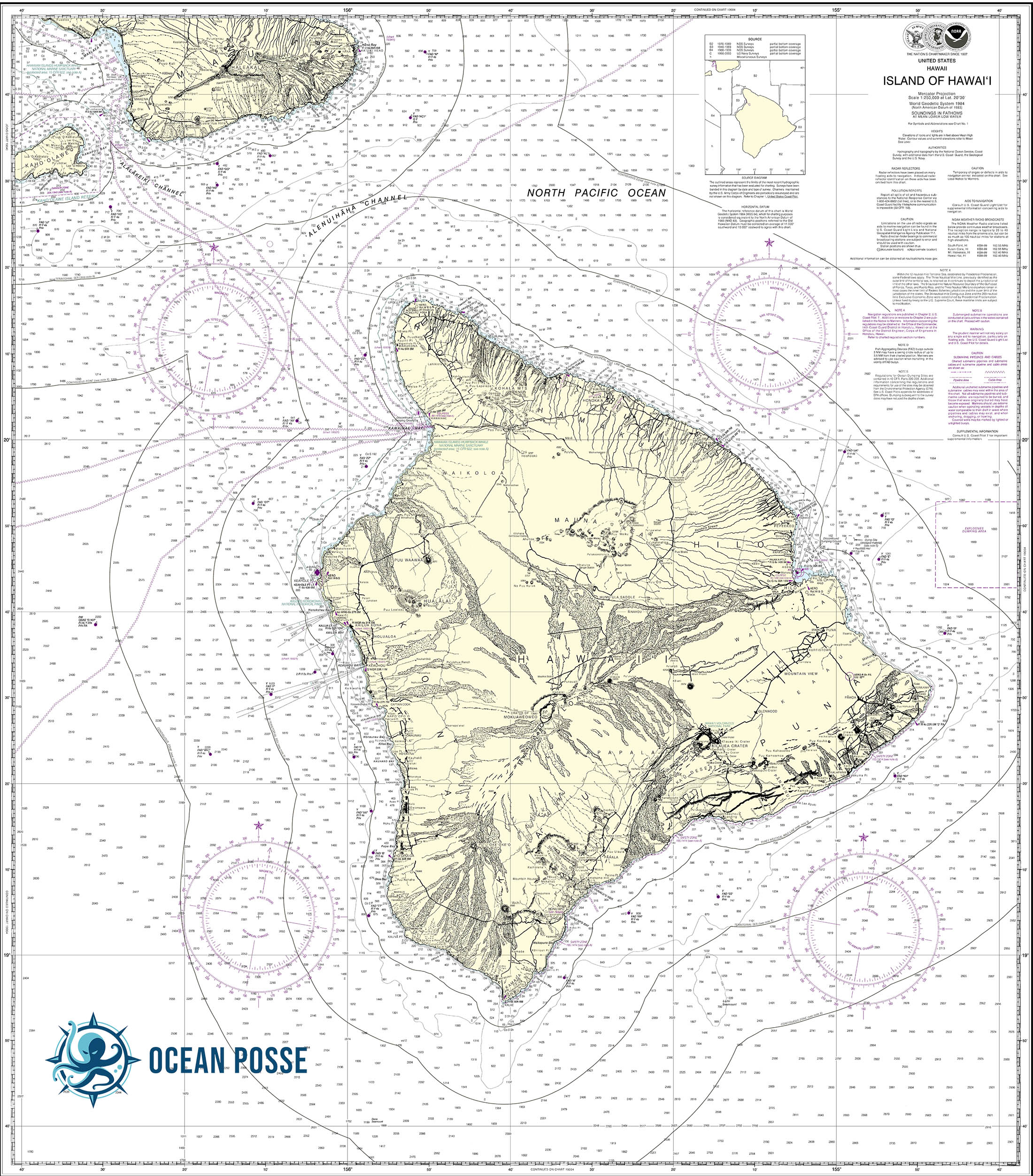
Hawaiʻi (Big Island): The Orchid Isle
- Overview: The Big Island is the largest and most diverse, featuring everything from volcanic landscapes to lush rainforests.
- Routes & Anchorages: Kailua-Kona and Hilo Harbor are major stops. The island’s west coast offers calm, sunny conditions, while the east side is more rugged and weather-exposed.
- Challenges: Active volcanic activity can impact water conditions, and unpredictable swells around South Point are notorious.
- Local Tips: Keep an eye on VOG (volcanic smog) conditions that can reduce visibility and air quality.
-
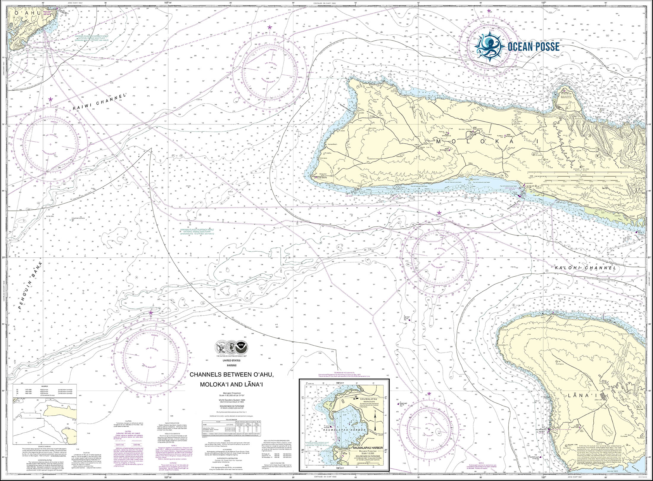
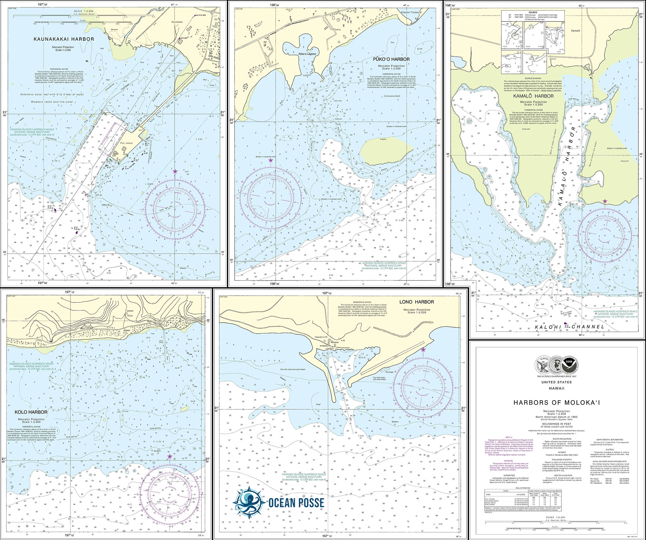
Molokaʻi: The Friendly Isle
- Overview: Moloka’i remains a land of unspoiled beauty, with a strong commitment to preserving its Hawaiian culture.
- Routes & Anchorages: Kaunakakai Harbor is a key entry point. The sea cliffs on the north side are among the tallest in the world, but they offer limited anchoring.
- Challenges: The island has strong, gusty trade winds and tricky currents.
- Local Tips: Respect local customs and avoid anchoring in areas designated as traditional fishing grounds.
-
Lanaʻi: The Pineapple Isle
- Overview: Known for its secluded beaches and the luxury of its remote setting.
- Routes & Anchorages: Manele Bay is the main anchorage, with pristine waters perfect for snorkeling.
- Challenges: Limited facilities and the island’s leeward side can experience sudden swells.
- Local Tips: Ideal for a day trip from Maui, but plan carefully as resources are scarce.
-
Niʻihau: The Forbidden Isle & Kahoʻolawe: The Sacred Isle
- Overview: Niʻihau is privately owned and off-limits to most visitors. Kahoʻolawe is uninhabited and revered as sacred land.
- Routes & Restrictions: Yachters can circumnavigate but are not allowed to land. These islands offer unique marine ecosystems but are challenging to access.
- Challenges: Treacherous waters and strict access regulations.
- Local Tips: Obtain permission and follow guidelines if planning to sail near these islands
Route Planning & Safety Tips
- Best Time to Cruise: The ideal months are from April to October, outside the hurricane season. Trade winds are generally more predictable during this time.
- Provisioning: Stock up in Honolulu or Kailua-Kona, as smaller islands have limited supplies. Fresh produce can be hard to find.
- Fueling Stations: Available in key harbors like Honolulu, Lahaina, and Hilo. Plan fuel stops carefully, especially if venturing to remote areas.
- Communication & Navigation: Ensure your yacht is equipped with reliable communication devices, as cell service can be spotty. Paper charts are essential.
- Environmental Awareness: Adhere to no-discharge zones, practice responsible waste disposal, and respect marine life habitats.
Cultural Insights and Local Customs
- Cultural Sensitivity: Understand the significance of Hawaiian traditions, especially when visiting sacred sites. Engage with the local community respectfully.
- Marine Conservation: Participate in efforts to preserve the islands’ unique ecosystems, like coral reef protection and marine mammal safety.
MARINAS
WEATHER
SEVERE WEATHER
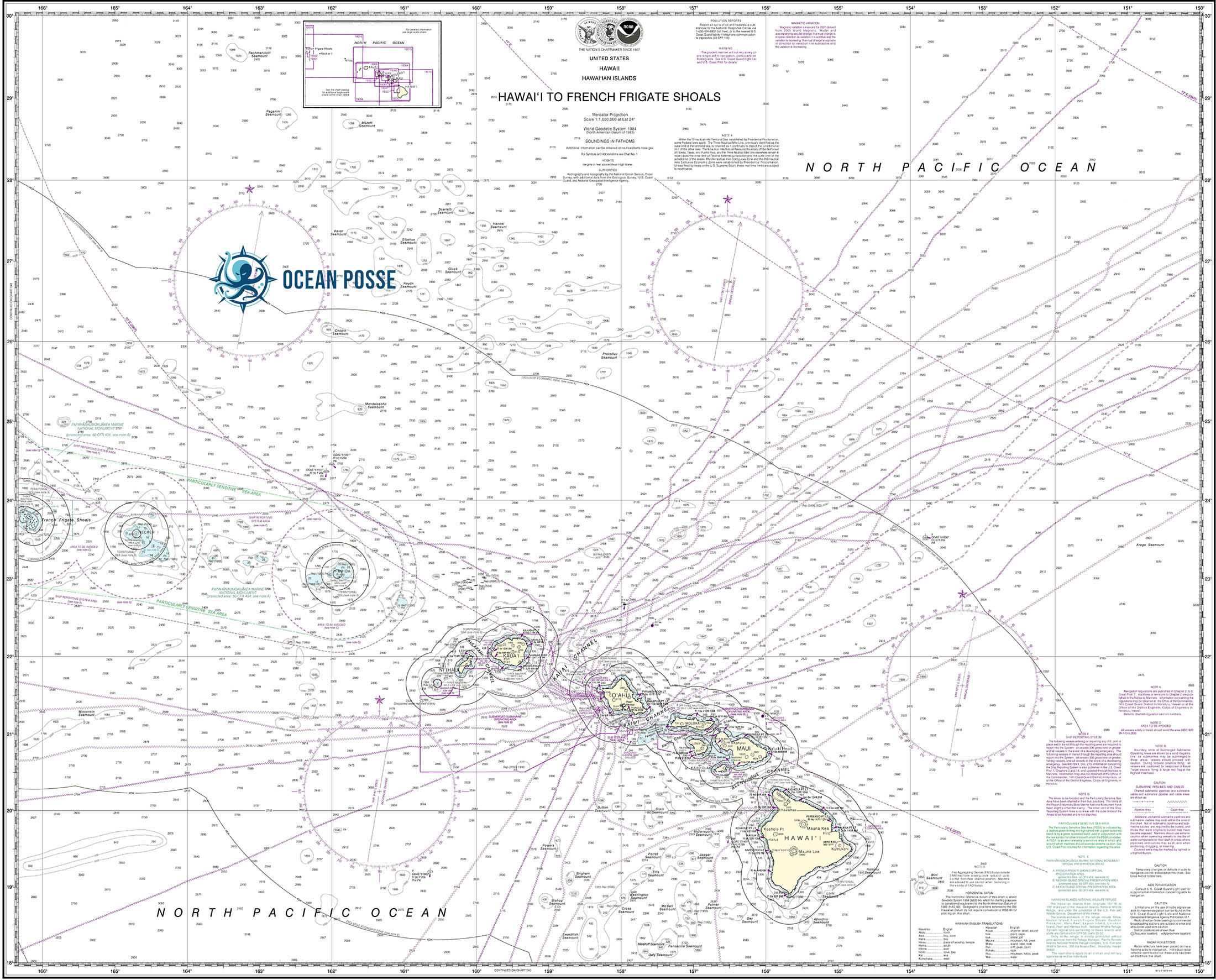
PILOT CHARTS
[/vc_custom_heading]
PORTS OF ENTRY
PORTS OF ENTRY
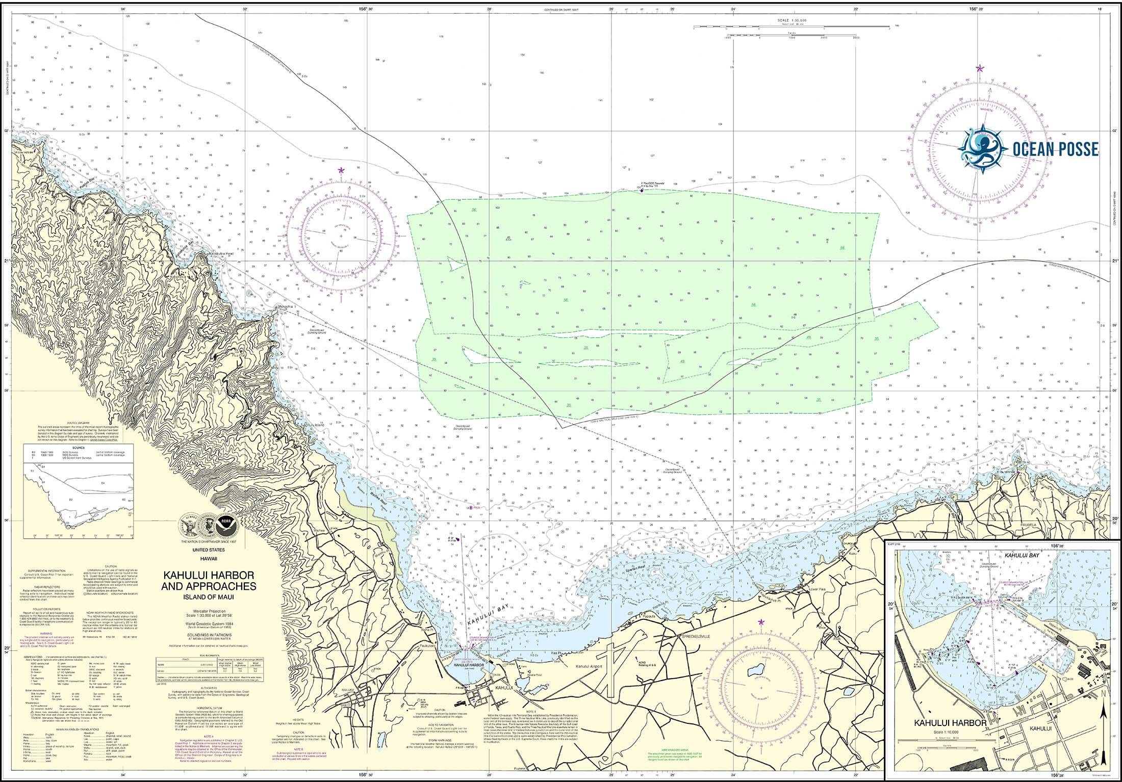
Hawaii (Big Island)
Hilo,
Kailua-Kona
Hnokohau
Kauai
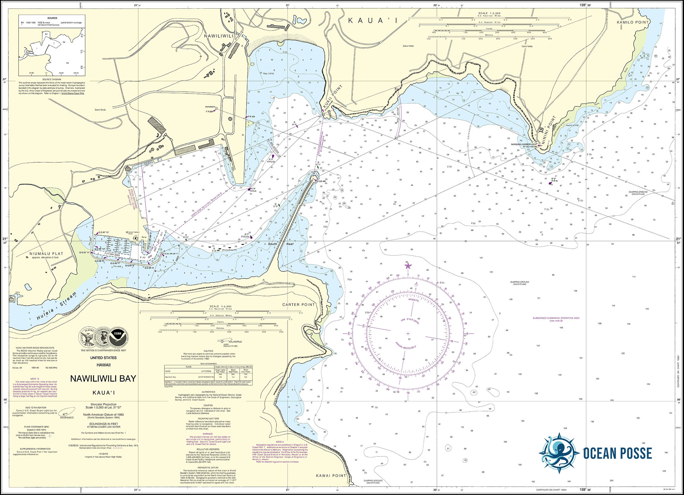
Nawiliwili
Maui
Kahului
Maalaea
Oahu
Barbers Point Harbour
Ko Olina
Honolulu
DOCUMENTS
MUST SEE
Oʻahu
- Pearl Harbor National Memorial
- Coordinates: 21.3649° N, 157.9496° W
- Best Time to Visit: Early mornings year-round to avoid crowds.
- Diamond Head State Monument
- Coordinates: 21.2619° N, 157.8050° W
- Best Time to Visit: Early mornings during winter months (November to March) for cooler temperatures.
- Waikiki Beach
- Coordinates: 21.2766° N, 157.8275° W
- Best Time to Visit: April to June and September to November for pleasant weather and fewer crowds.
- Hanauma Bay Nature Preserve
- Coordinates: 21.2690° N, 157.6938° W
- Best Time to Visit: Early mornings on weekdays to avoid crowds; closed on Mondays and Tuesdays.
- Polynesian Cultural Center
- Coordinates: 21.6397° N, 157.9234° W
- Best Time to Visit: Weekdays during the spring and fall for a more relaxed experience.
- Lanikai Beach
- Coordinates: 21.3933° N, 157.7156° W
- Best Time to Visit: Weekdays during spring and fall to avoid crowds.
- Byodo-In Temple
- Coordinates: 21.4290° N, 157.8374° W
- Best Time to Visit: Mornings during weekdays for a peaceful experience.
- Nuuanu Pali Lookout
- Coordinates: 21.3700° N, 157.7960° W
- Best Time to Visit: Early mornings for clear views and cooler temperatures.
- Iolani Palace
- Coordinates: 21.3069° N, 157.8583° W
- Best Time to Visit: Weekdays during mid-morning hours.
- Waimea Valley
- Coordinates: 21.6386° N, 158.0516° W
- Best Time to Visit: Spring and fall for blooming flora and comfortable weather.
Maui
- Haleakalā National Park
- Coordinates: 20.7097° N, 156.2537° W
- Best Time to Visit: Sunrise visits require reservations; consider visiting during sunset for fewer crowds.
- Road to Hāna
- Coordinates: 20.7895° N, 156.0030° W
- Best Time to Visit: Weekdays during dry season (April to October) for safer driving conditions.
- ʻĪao Valley State Monument
- Coordinates: 20.8550° N, 156.5450° W
- Best Time to Visit: Mornings during weekdays to avoid afternoon rain showers.
- Kāʻanapali Beach
- Coordinates: 20.9245° N, 156.6947° W
- Best Time to Visit: Early mornings during summer months for calm waters.
- Molokini Crater
- Coordinates: 20.6338° N, 156.4966° W
- Best Time to Visit: Early mornings during summer for optimal snorkeling conditions.
- Lāhainā Historic District
- Coordinates: 20.8783° N, 156.6825° W
- Best Time to Visit: Evenings during weekdays for a relaxed atmosphere.
- Maui Ocean Center
- Coordinates: 20.7917° N, 156.5011° W
- Best Time to Visit: Mornings during weekdays to avoid crowds.
- Waiʻānapanapa State Park
- Coordinates: 20.7850° N, 156.0020° W
- Best Time to Visit: Early mornings during weekdays for solitude.
- Makena Beach State Park (Big Beach)
- Coordinates: 20.6170° N, 156.4420° W
- Best Time to Visit: Mornings during weekdays for fewer crowds.
- Aliʻi Kula Lavender Farm
- Coordinates: 20.7410° N, 156.3260° W
- Best Time to Visit: Summer months (June to August) for peak lavender bloom.
Hawaiʻi (Big Island)
- Hawaiʻi Volcanoes National Park
- Coordinates: 19.4194° N, 155.2885° W
- Best Time to Visit: Year-round; check eruption updates for optimal viewing
Hawaiʻi (Big Island)
- Mauna Kea Summit and Observatories
- Coordinates: 19.8207° N, 155.4681° W
- Best Time to Visit: Sunset or evening for stargazing, year-round.
- Akaka Falls State Park
- Coordinates: 19.8687° N, 155.1542° W
- Best Time to Visit: Mornings during spring for lush scenery and cooler weather.
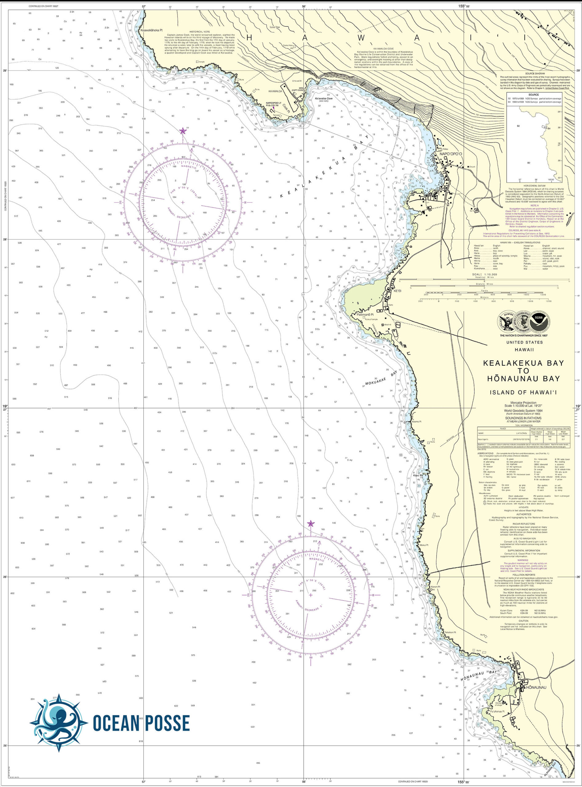
- Puʻuhonua o Hōnaunau National Historical Park
- Coordinates: 19.4215° N, 155.9091° W
- Best Time to Visit: Early mornings or late afternoons for cooler temperatures.
- Punaluʻu Black Sand Beach
- Coordinates: 19.1360° N, 155.5021° W
- Best Time to Visit: Mornings to see sea turtles basking on the shore.
- Rainbow Falls
- Coordinates: 19.7283° N, 155.1033° W
- Best Time to Visit: Early mornings for the best chance to see rainbows.
- Waipiʻo Valley Lookout
- Coordinates: 20.1224° N, 155.5942° W
- Best Time to Visit: Late mornings for clearer skies and panoramic views.
- Kona Coffee Living History Farm
- Coordinates: 19.5194° N, 155.9101° W
- Best Time to Visit: Spring and fall during coffee harvest season.
- Kaumana Caves State Park
- Coordinates: 19.6963° N, 155.1261° W
- Best Time to Visit: Mornings for cooler temperatures.
Kauaʻi
- Nā Pali Coast State Park
- Coordinates: 22.1400° N, 159.6381° W
- Best Time to Visit: May to September for calmer seas and hiking opportunities.
- Waimea Canyon State Park
- Coordinates: 22.0456° N, 159.6692° W
- Best Time to Visit: Mornings during spring and fall for clear views.
- Wailua Falls
- Coordinates: 22.0384° N, 159.3790° W
- Best Time to Visit: Early mornings to catch the sunlight on the falls.
- Hanalei Bay
- Coordinates: 22.2048° N, 159.4972° W
- Best Time to Visit: Summer for calm waters and beautiful sunsets.
- Kīlauea Lighthouse
- Coordinates: 22.2236° N, 159.4020° W
- Best Time to Visit: Winter months for whale watching.
- Spouting Horn
- Coordinates: 21.8775° N, 159.4710° W
- Best Time to Visit: Sunset for dramatic views.
- Allerton Garden (Lawai Valley)
- Coordinates: 21.9034° N, 159.5250° W
- Best Time to Visit: Early morning or late afternoon for guided tours and cooler weather.
REPAIRS AND SERVICE PROVIDERS
Hawaii offers a variety of chandleries, marine yards, and repair services across its islands. Here are some notable establishments:
Oahu:
- Keehi Marine Center: Located in Honolulu, this facility provides dry dock services, repair services, wet slips, a fuel dock, storage, and security.
- K&C Marine: Based in Oahu, K&C Marine offers comprehensive boat repair services, including painting, lettering, ceramic coating, and outboard motor repair.
- GZ Boatworks: Serving all of Oahu, GZ Boatworks provides mobile marine repair services, including motor work, fiberglass repair, restoration, electrical, plumbing, and solar installations.
- Hawaii Marine Solutions LLC: This company offers marine repair services with a focus on honesty and quality, serving the boating community of Oahu.
- Reliable Marine Hawaii: Specializing in mobile mechanical engine repair and maintenance, they are authorized dealers for Yamaha and Volvo, offering certified repairs and engine sales.
Hawaii (Big Island):
- Top Shape Marine Services: Located in Honokohau Harbor, Kailua-Kona, they specialize in diesel engines, hydraulic systems, electrical, electronics, generators, running gear, and gyro stabilizers.
Maui:
- Maui Mobile Marine: Founded in 2018, they offer marine repair services, including outboard and inboard motor service, electronics installation, trailer repair, light fabrication, and hull work.
Statewide:
- Marisco, Ltd.: Based in Kapolei, Marisco is Hawaii’s premier shipyard, providing ship repair services to governmental and commercial marine sectors, including the U.S. Navy, Coast Guard, and Army.
- Pacific Shipyards International: Located in Honolulu, they offer ship repair services and have been serving Hawaii’s maritime community for over 80 years.
EMERGENCIES AND SAR INFO

FRENCH POLYNESIA 🇵🇫 Cruising the South Pacific with the Ocean Posse
 FRENCH POLYNESIA – MARQUESAS
Stop overHand book 2024-2025 -FrenchPolynesia – PDF >>
Arriving in Hiva Oa: Atuona Bay
The main entry point for sailors is Atuona, a small town nestled at the base of towering volcanic cliffs. Atuona Bay, where sailors usually anchor, is well-protected and provides a peaceful welcome with calm waters against the dramatic backdrop of Mt. Temetiu. As the second-largest settlement in the Marquesas, Atuona has basic amenities and a friendly community that warmly welcomes visitors.
Sailors should be prepared for strong trade winds that sweep through the bay. Anchoring can be somewhat challenging due to the swell and tidal changes, but the beautiful scenery and nearby amenities make it a popular choice.
Paul Gauguin and Jacques Brel: Artists Drawn to Hiva Oa
Hiva Oa is famously the final resting place of two iconic artists: painter Paul Gauguin and musician Jacques Brel. Both were drawn to Hiva Oa for its solitude, beauty, and vibrant culture, and each left a significant mark on the island. Their graves are located in the Calvary Cemetery, set on a hill overlooking Atuona. Visiting their graves has become a pilgrimage for admirers who come to pay homage to their artistry and find inspiration in the same landscapes that captivated these artists.
- Paul Gauguin: Known for his post-Impressionist paintings, Gauguin moved to Hiva Oa in search of an idyllic life far from Europe. His house, now reconstructed as the Paul Gauguin Cultural Center, showcases reproductions of his paintings and provides insight into his time on the island.
- Jacques Brel: The Belgian musician spent the final years of his life on Hiva Oa, where he often used his small plane to help locals travel between islands. The Jacques Brel Museum features memorabilia, recordings, and his plane, “Jojo,” on display.
Archaeological Sites and Ancient Marquesan Culture
Hiva Oa is a treasure trove of ancient Polynesian culture, with well-preserved marae (temples) and massive stone tikis that date back centuries. These archaeological sites provide a window into the Marquesan civilization, which developed intricate social structures, art, and spiritual practices.
- Puamau Valley and Iipona Archaeological Site: One of the most significant sites in Hiva Oa, Iipona is located in the remote Puamau Valley and features some of the largest tikis in the Marquesas, including Tiki Takaii, a massive stone figure that is believed to embody ancient ancestors. These sculptures, crafted from volcanic rock, are monumental in size and spiritual significance, reflecting the island’s powerful connection to its past.
- Ta’a Oa Valley: This valley, also known as the Bay of Traitors, is home to smaller, lesser-known sacred sites and an impressive landscape where dramatic cliffs plunge into the ocean. Exploring this area offers sailors a unique perspective on the island’s ancient past, as it remains largely unaltered and feels like stepping back in time.
The Wild Beauty of Hiva Oa: Nature and Adventure
Hiva Oa’s landscape is exceptionally diverse, from towering volcanic peaks and lush valleys to waterfalls and black sand beaches. For sailors who enjoy hiking and exploring, Hiva Oa offers various trails that showcase its natural beauty.
- Mt. Temetiu: The highest peak on Hiva Oa, Mt. Temetiu offers breathtaking panoramic views over the island and neighboring valleys. The hike to the summit is challenging but rewarding, with dense tropical foliage, stunning viewpoints, and the chance to see rare flora and fauna along the way.
- Waterfalls: Numerous waterfalls cascade down Hiva Oa’s rugged landscape, especially after rain showers. The Hanaui Valley, in particular, is known for its beautiful waterfalls, and it’s a great spot for swimming and cooling off after a long hike.
The island’s remoteness and varied landscapes make it ideal for adventurous sailors looking to connect with nature and escape the bustle of modern life. The trails, bays, and cliffs offer incredible opportunities for photographers and nature lovers alike, with ever-changing scenery that reflects the untouched beauty of the Marquesas.
Life in Atuona: The Spirit of the Marquesas
Atuona, though small, is the heart of Hiva Oa’s social life and a cultural hub for the island. The town’s markets are filled with fresh produce and local delicacies, like coconut, breadfruit, taro, and tropical fruits. The Marquesan people are known for their warmth and hospitality, often inviting visitors to partake in traditional meals and celebrations.
- Cultural Gatherings and Festivals: Marquesans take pride in their cultural heritage, and Hiva Oa hosts frequent gatherings where locals perform traditional dances, songs, and drumming. The music is vibrant and deeply tied to the island’s history, and it’s an unforgettable experience to witness these performances against the island’s stunning backdrop.
- Handicrafts: Artisans in Atuona and other villages on Hiva Oa are known for their tapa (cloth made from tree bark) and wood carvings, especially intricate designs in wood and bone. Visitors can purchase locally crafted souvenirs that reflect the Marquesas’ artistic tradition and unique style, especially items featuring the island’s iconic tiki motifs.
Flora, Fauna, and Marine Life
The lushness of Hiva Oa makes it a haven for a variety of plant and animal life. Unlike the arid landscapes of neighboring Ua Huka, Hiva Oa has dense tropical forests filled with exotic plants, including breadfruit ..
Tahuata
the smallest inhabited island in the Marquesas, is a gem known for its pristine white-sand beaches, crystal-clear waters, and rich cultural history. For sailors exploring the Marquesas, Tahuata offers a more intimate, laid-back experience, where you can enjoy secluded anchorages, vibrant coral reefs, and genuine connections with the local community.
Anchoring in Hanamoenoa Bay: A Tropical Paradise
Hanamoenoa Bay, on the northwestern coast of Tahuata, is often considered one of the most beautiful anchorages in the Marquesas. This idyllic bay boasts calm, turquoise waters, making it a favorite for sailors who want a serene and sheltered spot to relax. The beach is framed by lush vegetation, with white sands that contrast strikingly against the island’s dramatic, rugged coastline.
The bay offers excellent snorkeling opportunities, where you can spot vibrant coral reefs, tropical fish, and even the occasional manta ray. The peacefulness of Hanamoenoa Bay, combined with its natural beauty, makes it a perfect spot for spending a few days unwinding and soaking in the Marquesan paradise.
Vaitahu Village: A Glimpse into Marquesan History
The main village of Tahuata, Vaitahu, is historically significant as the site of the first European landing in the Marquesas. In 1595, Spanish explorer Álvaro de Mendaña arrived in Tahuata, making it one of the earliest points of contact between Europeans and Polynesians. The village’s history is marked by the encounters between missionaries, explorers, and local Marquesan leaders over centuries, leaving a deep cultural impact that is still felt today.
Visitors to Vaitahu can explore the beautiful Church of Vaitahu, a Catholic church that stands as a blend of Marquesan and European architectural styles. Built with materials gifted from the Vatican, including stained glass and wooden carvings, the church is a testament to the island’s spiritual heritage. The local artisans’ wood carvings and tikis around the church reflect the blending of Marquesan symbolism with Christian influence, creating a unique cultural landmark.
Cultural Craftsmanship: Tahuata’s Renowned Tattoo Art and Handicrafts
Tahuata is known for its skilled artisans, particularly its tattoo artists and wood carvers. Marquesan tattoo art holds deep cultural significance, symbolizing identity, ancestry, and status within the community. Tahuata’s tattoo artists create intricate designs that reflect traditional Marquesan motifs, often incorporating elements of nature, mythology, and personal significance for the wearer. Many sailors and visitors to Tahuata are drawn to these tattoos as a lasting memento of their time in the Marquesas, honoring both the journey and the cultural depth of the islands.
Wood carving is another prominent craft in Tahuata. Artisans in Vaitahu and other small villages carve stunning items from local wood, such as ironwood and rosewood, often depicting traditional Marquesan designs like tiki figures and animal motifs. These intricate carvings make for memorable souvenirs that capture the essence of the island’s artistry.
Exploring Secluded Beaches and Untouched Nature
Apart from Hanamoenoa Bay, Tahuata has several other secluded beaches and bays that are ideal for a peaceful day of exploration. Many of these beaches are isolated and can only be reached by boat, offering sailors a rare chance to enjoy pristine sands and clear waters without any crowds.
One such beach is Hapatoni, located south of Vaitahu. Hapatoni is a quiet village set along a beautiful coastal road lined with ancient stone pathways, towering coconut palms, and flowering trees. The beach here is less developed and feels almost untouched, providing a genuine sense of seclusion and tranquility. For those interested in local culture, Hapatoni is home to a small community where you can interact with artisans and gain insight into traditional Marquesan life.
Marine Life and Snorkeling
The waters surrounding Tahuata are teeming with marine life, making it an ideal spot for snorkeling and underwater exploration. The coral reefs around the island are home to diverse fish species, colorful corals, and larger marine animals such as turtles and rays. The clarity of the water around Tahuata is particularly striking, allowing for excellent visibility and unforgettable snorkeling experiences.
Between May and November, sailors may even have the chance to spot humpback whales migrating through the Marquesas. Observing these majestic creatures in their natural habitat is a powerful reminder of the Marquesas’ rich biodiversity and the profound beauty of French Polynesia’s marine ecosystems.
Fatu Hiva
often described as the most striking and remote island in the Marquesas, is a place of unparalleled natural beauty and cultural richness. Known for its iconic Bay of Virgins, rugged landscapes, and traditional way of life, Fatu Hiva embodies the adventurous spirit of French Polynesia and is a bucket-list destination for sailors exploring the South Pacific.
Arrival and First Impressions: Hanavave and the Bay of Virgins
Most sailors anchor in the legendary Bay of Virgins (Hanavave Bay) on Fatu Hiva’s western coast. This dramatic bay, often heralded as one of the most beautiful anchorages in the world, is framed by towering volcanic spires and sheer cliffs cloaked in lush greenery. The bay’s original name, “Baie des Verges” (Bay of Penises), was adapted to “Bay of Virgins” by missionaries, inspired by the rock formations that rise like cathedral spires around the anchorage.
Sailing into Hanavave Bay is an unforgettable experience, especially at sunrise or sunset, when the bay is bathed in warm hues that highlight the rugged cliffs and emerald foliage. However, anchoring here can be challenging due to swells, so careful anchoring techniques are recommended. Despite these challenges, the bay’s breathtaking scenery and tranquil atmosphere make it worth the effort.
Exploring Hanavave Village: A Glimpse into Marquesan Life
The small village of Hanavave, located on the shores of the Bay of Virgins, is home to a tight-knit community where traditional Marquesan customs are still widely practiced. In Hanavave, life moves at a slow and peaceful pace. Villagers are known for their warmth and hospitality, often inviting sailors to experience the local way of life.
Handicrafts are a vital part of the village economy, with artisans producing beautiful tapa (cloth made from tree bark) and wood carvings. These crafts are often decorated with intricate Marquesan symbols representing ancestral spirits, animals, and natural elements. Many sailors leave Fatu Hiva with a piece of tapa or a wooden carving as a cherished memento of their journey.
Puamau Valley and Iipona Archaeological Site
Fatu Hiva is steeped in ancient Marquesan culture, and visitors to the island have the chance to explore some of its most sacred sites. The Iipona Archaeological Site in the Puamau Valley is home to some of the largest stone tikis in the Marquesas. These massive stone figures, carved from volcanic rock, are believed to embody ancestors and are highly significant in Marquesan spirituality. Tiki Takaii, the tallest tiki in the Marquesas, stands at over 8 feet tall and exudes a sense of mystery and power.
Exploring these ancient sites offers a profound glimpse into the island’s spiritual heritage. Many sailors find that visiting these tikis evokes a deep connection to the Marquesas’ past, feeling the presence of a civilization that has existed on these islands for over a thousand years.
The Hike from Hanavave to Omoa: A Journey Through Paradise
For adventurous sailors, one of the highlights of visiting Fatu Hiva is the challenging yet rewarding hike between Hanavave and Omoa, another village located on the southern coast. This hike, which takes approximately 3-4 hours, traverses some of the island’s most stunning landscapes, from lush rainforests and fruit-laden groves to sweeping ocean views and rugged mountain terrain.
The trail winds through valleys and ridges, offering panoramic vistas of the island and the ocean beyond. Along the way, hikers can enjoy wild fruit trees bearing mangoes, guavas, and bananas. Although demanding due to steep ascents and rugged terrain, this hike is considered one of the most beautiful in the Marquesas. Reaching Omoa, travelers are greeted by a welcoming community and the satisfaction of completing an unforgettable journey.
Omoa Village: Artisans and Traditions
The village of Omoa, located on Fatu Hiva’s southeastern coast, is another hub of traditional Marquesan culture. In Omoa, local artisans specialize in creating tapa cloth and sculptures from native wood and stone. Watching the creation of tapa cloth, which involves pounding tree bark until it forms a thin, paper-like material, is a unique cultural experience that reveals the skill and patience involved in Marquesan craftsmanship.
The locals in Omoa are also known for their skills in producing pareo (colorful cloth wraps) and jewelry made from shells, seeds, and bones. These handmade items capture the beauty of the island’s natural resources and reflect a deep respect for nature. Many sailors enjoy spending time in Omoa’s small workshops, learning about the traditional methods and acquiring handcrafted pieces that represent Fatu Hiva’s spirit.
Marine Life and Snorkeling
The waters around Fatu Hiva are teeming with marine life, making it an ideal location for snorkeling and diving. The island’s remote location and limited tourism mean its coral reefs are relatively untouched, providing a pristine underwater landscape filled with vibrant corals, tropical fish, and occasionally, manta rays and dolphins.
Ua HukA
one of the lesser-visited islands in the Marquesas, offers an experience marked by untamed landscapes, rich history, and unique cultural heritage. For sailors exploring the Marquesas, Ua Huka’s dramatic scenery, archaeological sites, and distinct, arid beauty provide an intriguing contrast to the lush, tropical atmosphere of its neighboring islands.
Arrival and First Impressions
Ua Huka is distinct within the Marquesas for its rugged, almost desert-like terrain. Upon arrival, sailors are met with sweeping cliffs, steep valleys, and rocky coastlines. The island has an air of isolation, with red and brown hills that reveal the island’s volcanic origins and offer a stark, otherworldly beauty. This uniqueness extends to its more challenging anchorages, making Ua Huka a choice for the more adventurous sailor looking for a quieter, wilder side of French Polynesia.
The main harbor is at Vaipaee Bay, a relatively narrow, steep-sided inlet that provides some shelter. Sailors should take caution as the swells can make anchoring tricky, especially during windy conditions. The sense of remoteness and adventure is palpable here, as only a handful of yachts visit Ua Huka each year.
Exploring Ancient Heritage and Archaeological Sites
Ua Huka is rich in archaeological sites, with some of the best-preserved remnants of ancient Polynesian culture. The island has several petroglyphs, tiki statues, and sacred sites that give insight into the Marquesan civilization. A prominent site to explore is Me’ae Tepeu, a ceremonial area with stone carvings and tiki figures. These sites are not only significant to Marquesan history but also offer a deep sense of connection to the island’s spiritual heritage.
One of the most distinctive aspects of Ua Huka is its archeological museum in Vaipaee village. This museum showcases artifacts from the island’s past, including ancient tools, carvings, and traditional artifacts, all preserved with pride by the local community. For sailors interested in anthropology and the history of Pacific navigation, Ua Huka’s museum is a treasure trove.
The Wild Horses of Ua Huka
The island is also famous for its wild horses, a legacy from colonial times that roam freely across the rugged terrain. These horses, along with wild goats and cattle, are a unique sight on the island’s rocky hills and plains. Spotting these animals while hiking or exploring by vehicle adds a layer of fascination to the experience, showcasing the blend of Marquesan nature and human history.
Horseback riding is popular on Ua Huka, and visitors have the opportunity to ride along scenic trails that offer panoramic views of the coastline and volcanic ridges. Guided tours allow visitors to reach otherwise inaccessible areas, and horseback travel is a perfect way to experience the island’s raw beauty and rugged charm.
Tikis and Rock Carvings at Hane and Hokatu
The small villages of Hane and Hokatu, located along the island’s eastern coast, are not only centers of community life but also areas rich in cultural significance. Here, sailors can visit local artisans who specialize in wood and stone carvings, creating works inspired by ancient Marquesan art. Many of the tikis and carvings depict ancestral figures and local legends, symbolizing protection, strength, and connection to nature.
Hane Bay, in particular, is known for its archeological sites and well-preserved petroglyphs. Explorers can hike to sites where ancient Marquesans carved symbols and figures into the rock, offering glimpses of a long-lost civilization. Hokatu is similarly rich in cultural artifacts, and its proximity to coastal trails makes it a great spot for both hiking and cultural immersion.
Flora, Fauna, and Botanical Curiosities
Ua Huka has an arid environment, unusual for the Marquesas, which means that its vegetation is more sparse and hardy. Despite this, the island is home to several endemic plants and trees, as well as vibrant flowers that stand out against the dry landscape. Among the unique flora are the miro and toa trees, both of which are significant in Marquesan culture, often used in carving and other traditional crafts.
For bird lovers, Ua Huka offers a unique treat: the island is known for its bird sanctuary, where rare and endangered species such as the Marquesan kingfisher and the ultramarine lorikeet (or pihiti) can be spotted. Birdwatching enthusiasts may find Ua Huka one of the best places in the Marquesas to observe these rare species in their natural habitat.
Nuku Hiva
the largest island in the Marquesas, is an extraordinary destination for sailors and explorers alike. Known for its awe-inspiring landscapes, archaeological significance, and rich cultural heritage, Nuku Hiva offers a well-rounded mix of adventure, history, and natural beauty. As the administrative center of the Marquesas, the island combines the practical conveniences of a main port with the untouched charm of its rugged interior.
Arrival at Taiohae Bay: The Gateway to Nuku Hiva
Taiohae Bay, a wide and well-protected harbor on Nuku Hiva’s southern coast, serves as the primary anchorage and main port for sailors visiting the island. This natural harbor, nestled within an ancient volcanic caldera, is one of the most scenic and welcoming anchorages in the Marquesas. Framed by lush, green mountains, Taiohae Bay provides a safe and scenic spot to anchor and is close to the island’s administrative center.
The town of Taiohae, which wraps around the bay, is the island’s largest settlement and the hub for supplies, fuel, and basic amenities. Sailors arriving in Taiohae are greeted by a friendly and laid-back community, as well as local artisans who display their crafts along the waterfront. The area is bustling yet maintains a peaceful vibe, offering a gentle introduction to life on Nuku Hiva.
Exploring Taiohae: Cultural Landmarks and Local Life
In Taiohae, visitors will find various cultural sites that reflect the island’s long history and deep-rooted traditions. Along the bay, carved stone tikis and wooden sculptures add a sense of mystery and reverence, honoring Nuku Hiva’s ancestral spirits and the island’s Polynesian heritage.
- Notre-Dame Cathedral of Taiohae: This unique church is constructed with stones from each of the Marquesas Islands and decorated with local wood carvings, blending Marquesan artistry with Catholic influence. The carved wooden doors, tikis, and traditional designs make it a visually stunning and culturally rich site to explore.
- Handicrafts and Markets: The town’s market offers a variety of local goods, including intricately carved bone and wood jewelry, coconut and breadfruit-based dishes, and handicrafts that showcase traditional Marquesan craftsmanship. Shopping here supports local artisans and provides a chance to bring home a piece of the island’s unique culture.
Hiking and Adventuring in the Taipivai Valley
Nuku Hiva is famous for its dramatic landscapes, and the Taipivai Valley on the eastern side of the island is a highlight. Known for its lush vegetation, towering cliffs, and ancient archeological sites, the valley is accessible by a scenic drive or a challenging yet rewarding hike.
The Taipivai Valley is historically significant as the setting for Herman Melville’s novel Typee, based on his experiences living among the indigenous Marquesans. For hikers, this valley offers trails that pass through dense jungle, ancient marae (sacred platforms), and stone tiki statues, immersing visitors in the natural and cultural heritage of the Marquesas.
- Hakaui Valley and Vaipo Waterfall: A standout attraction in the Taipivai Valley, the Vaipo Waterfall is one of the tallest waterfalls in French Polynesia, cascading down a sheer cliff over 350 meters (1,148 feet). The hike to reach the falls is challenging but worthwhile, taking you through dense rainforest, river crossings, and ancient stone paths. The sight of the Vaipo Waterfall is unforgettable, and it offers a refreshing swimming spot for those willing to brave the cool waters.
Archaeological Sites and Ancient Tikis
Nuku Hiva is dotted with ancient archaeological sites that provide a glimpse into the lives of the island’s early inhabitants. These sites are both spiritually significant and fascinating for their artistry and craftsmanship.
- Kamuihei, Hikokua, and Tahakia Sites: Located near Taiohae, these three archaeological sites are some of the best-preserved in the Marquesas. They feature tohua (ceremonial plazas), paepae (stone platforms), and massive stone tikis that reflect the spiritual practices and social structures of ancient Marquesan society. Walking among these ancient ruins, sailors can feel the weight of centuries and the enduring legacy of Marquesan culture.
These sites often feature traditional carvings and are surrounded by towering banyan trees, creating a mystical atmosphere. Local guides are available to explain the cultural and historical significance of these locations, providing a deeper understanding of Nuku Hiva’s ancestral heritage.
Exploring Hatiheu Bay and the Village of Hatiheu
On Nuku Hiva’s northern coast, Hatiheu Bay is a stunning anchorage surrounded by steep, green cliffs and a picturesque black-sand beach. The small village of Hatiheu, located at the edge of the bay, is known for its well-preserved archaeological sites and welcoming community.
- Ancient Temples and Petroglyphs: The area around Hatiheu has several ancient marae and petroglyphs, many of which depict Marquesan symbols and stories. The village’s tohua and paepae were historically used for ceremonial gatherings and are an essential part of the local heritage.
- Hiking to Anaho Bay: For those who enjoy trekking, a hike from Hatiheu to nearby Anaho Bay is an absolute must. Anaho Bay is one of the few bays in the Marquesas with a coral reef, providing excellent snorkeling opportunities and calm, clear waters for a relaxing swim. The hike to Anaho is challenging but offers panoramic views and a chance to explore Nuku Hiva’s diverse landscape, from rainforest trails to coastal cliffs.
Marine Life and Diving in Nuku Hiva
The waters around Nuku Hiva are teeming with marine life, making it a paradise for snorkeling and diving enthusiasts. The island’s remoteness and pristine environment support a healthy ecosystem where vibrant coral reefs and a diversity of fish species flourish.
Ua Pou
one of the most visually striking islands in the Marquesas, is known for its dramatic spire-like peaks that rise high above the lush landscape. This unique geological feature sets Ua Pou apart and makes it a memorable destination for sailors and adventurers exploring French Polynesia. The island is also rich in culture, with vibrant traditions, skilled artisans, and scenic villages that offer a warm welcome to visitors.
Arrival and First Impressions: The Iconic Peaks of Ua Pou
As sailors approach Ua Pou, they are immediately struck by the island’s distinct profile. Ua Pou’s landscape is dominated by towering volcanic spires, which include the famous Poumaka and Poutetaunui peaks that rise over 1,200 meters (3,937 feet) above sea level. These massive stone pillars, often shrouded in mist, create a dramatic and surreal scene that appears almost otherworldly.
The main anchorage on Ua Pou is located near Hakahau Bay, the island’s principal harbor and the heart of the community. Hakahau is a well-protected bay surrounded by a black-sand beach and verdant hillsides. Upon arrival, sailors are welcomed by the picturesque village of Hakahau, with its charming waterfront and traditional Polynesian ambiance.
Hakahau Village: A Hub of Culture and Artistry
Hakahau is the largest village on Ua Pou and serves as the island’s cultural and social center. Here, sailors can immerse themselves in the day-to-day life of the Marquesan people, enjoying traditional music, dance, and craftwork. The village is known for its lively atmosphere and friendly locals who take pride in their culture and are always eager to share it with visitors.
- Local Market and Artisans: Ua Pou is famous for its artisans, particularly skilled stone and wood carvers. The island’s volcanic rock provides a unique medium for crafting intricate sculptures, tikis, and decorative items. Many of the works feature traditional Marquesan motifs, making them meaningful souvenirs of the island. The Hakahau market is also a great place to find local delicacies, fresh produce, and woven handicrafts.
- Tohua and Cultural Events: The village has a traditional tohua (ceremonial plaza) where cultural events and performances are held. During festivals or special gatherings, locals showcase traditional Marquesan dances and songs that tell stories of the island’s history, mythology, and connection to nature. The sounds of drumming and chanting fill the air, creating an immersive experience that highlights the cultural richness of Ua Pou.
Exploring the Volcanic Landscapes and Hiking the Peaks
Ua Pou’s volcanic spires are a hiker’s paradise, attracting adventurous travelers eager to explore the island’s rugged terrain. While some peaks are challenging to access and require local guides, there are several scenic trails that offer stunning views and an up-close look at the island’s unique geology.
- Poumaka Trail: This challenging hike leads to the base of Poumaka, one of Ua Pou’s most prominent peaks. The journey takes you through dense forests, across rocky ridges, and to vantage points where you can marvel at the island’s striking volcanic formations. The hike offers breathtaking views of the spires, surrounding valleys, and ocean beyond, making it a rewarding trek for those up for the challenge.
- Views of the Spires: For sailors who may not wish to undertake a strenuous hike, there are several areas near Hakahau where you can enjoy panoramic views of Ua Pou’s peaks without leaving the main village. The interplay of sunlight and shadow on the spires, particularly at sunrise and sunset, is an awe-inspiring sight and a must-see for photographers and nature enthusiasts.
Hakamoui Valley and Ancient Sites
The Hakamoui Valley, located inland from Hakahau, is a verdant area known for its ancient marae (sacred platforms) and petroglyphs. This valley holds significant cultural and historical importance, as it was once a key site for traditional Marquesan ceremonies and gatherings.
Exploring the valley provides a sense of connection to Ua Pou’s past, with remnants of stone structures and sacred carvings that date back centuries. Local guides are often available to lead tours through the valley, sharing stories of the island’s ancestors and explaining the meanings behind the petroglyphs and archaeological features.
The Village of Hakahetau: Tranquility and Tradition
Hakahetau, a smaller village located on Ua Pou’s northwest coast, offers a more tranquil experience away from the main hub of Hakahau. Known for its peaceful atmosphere and pristine natural surroundings, Hakahetau is an ideal spot for sailors looking to relax and enjoy the beauty of Ua Pou’s coastline.
- Scenic Waterfalls: A short hike from Hakahetau leads to a beautiful waterfall nestled within the forest. The waterfall cascades into a clear pool, offering a refreshing spot for a swim and a quiet place to enjoy the natural surroundings. This area is relatively untouched, allowing visitors to appreciate Ua Pou’s unspoiled beauty.
- Fishing and Agriculture: The villagers of Hakahetau rely on fishing and agriculture as part of their daily life. The community is known for its commitment to traditional practices, such as fishing using traditional methods and cultivating local crops like breadfruit, taro, and coconut. Visitors to Hakahetau often find themselves invited to share a meal or sample local delicacies, experiencing firsthand the island’s warm hospitality.
MARINAS & MARINE SERVICES


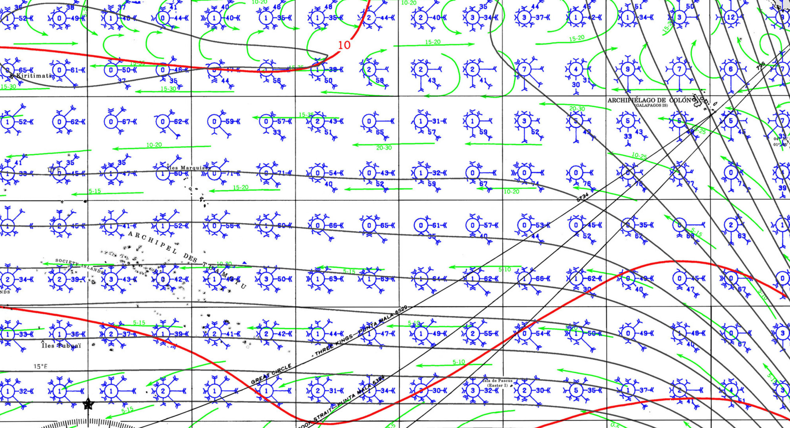
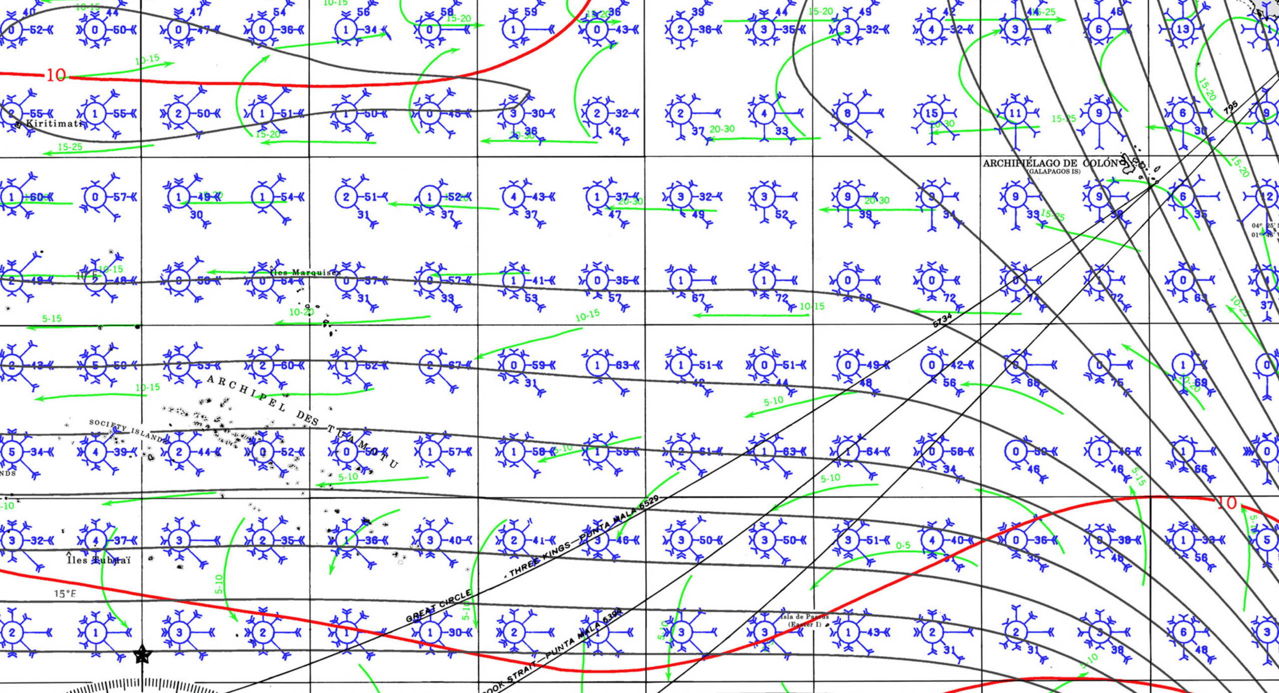
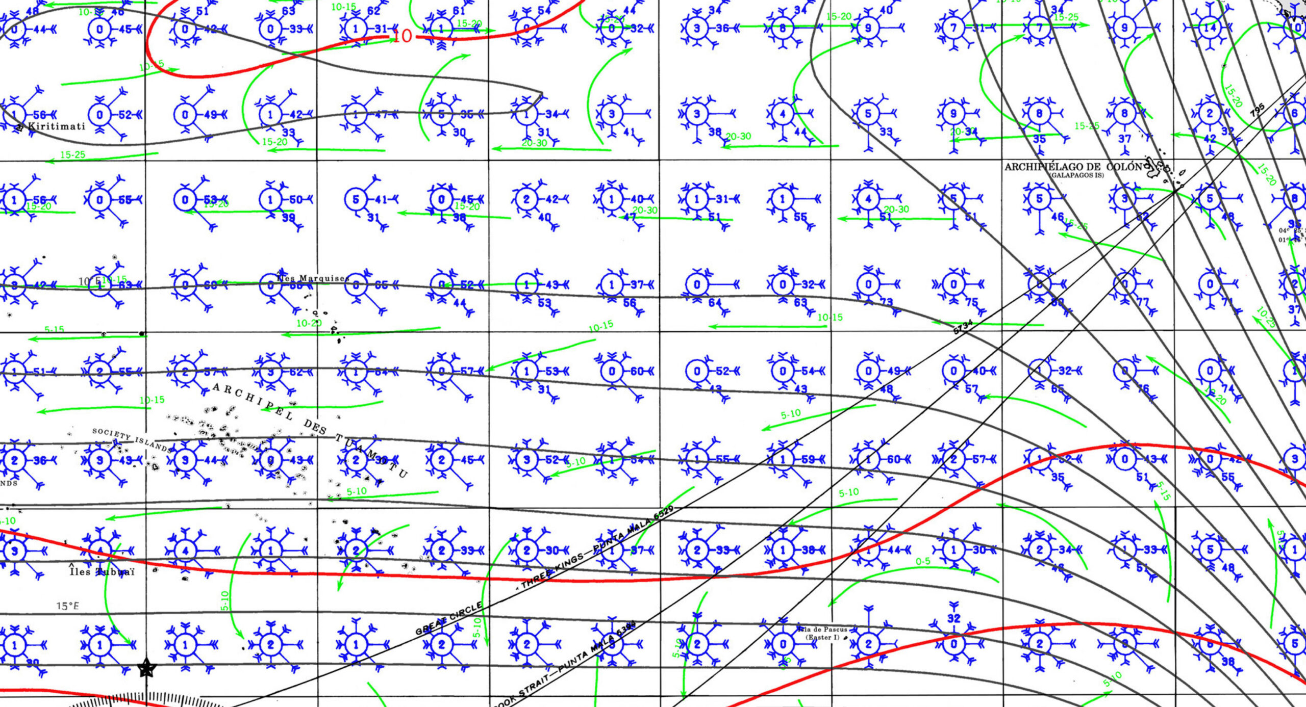
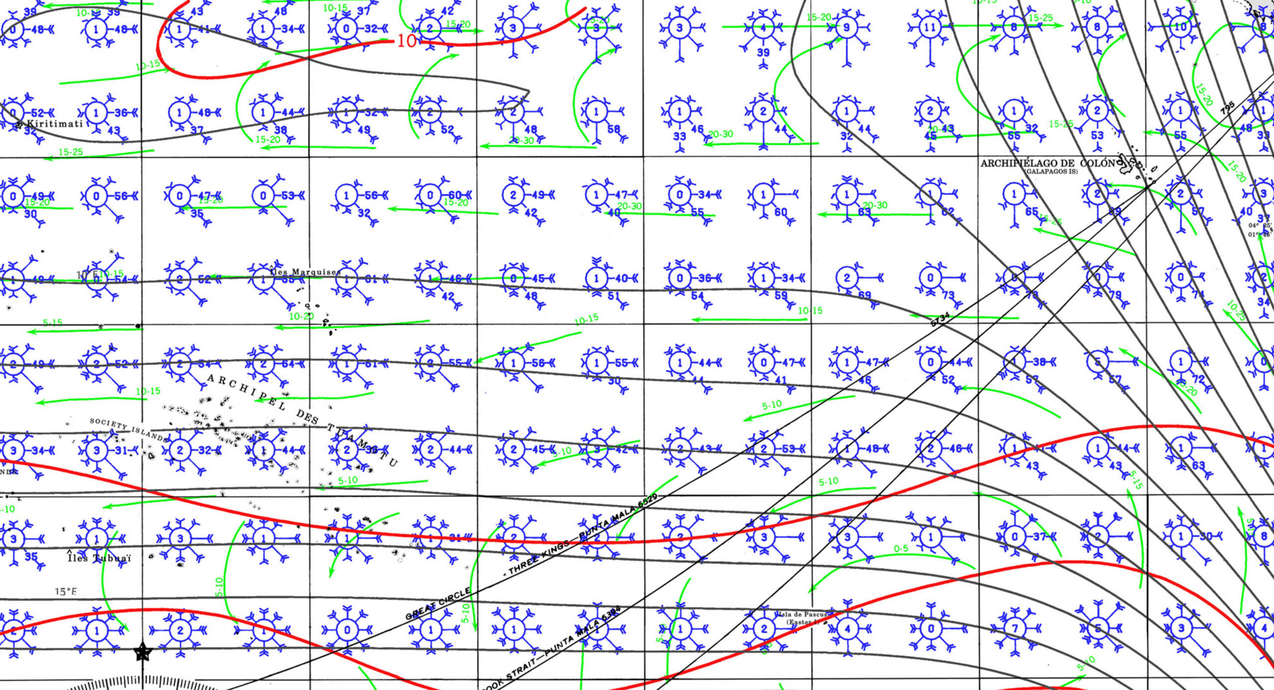
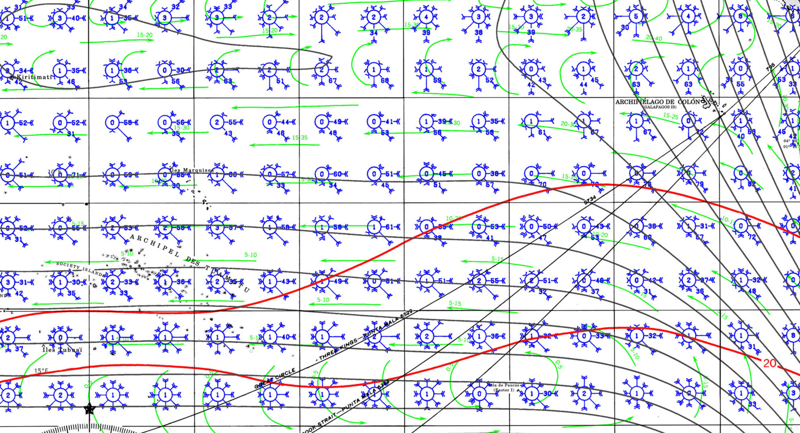

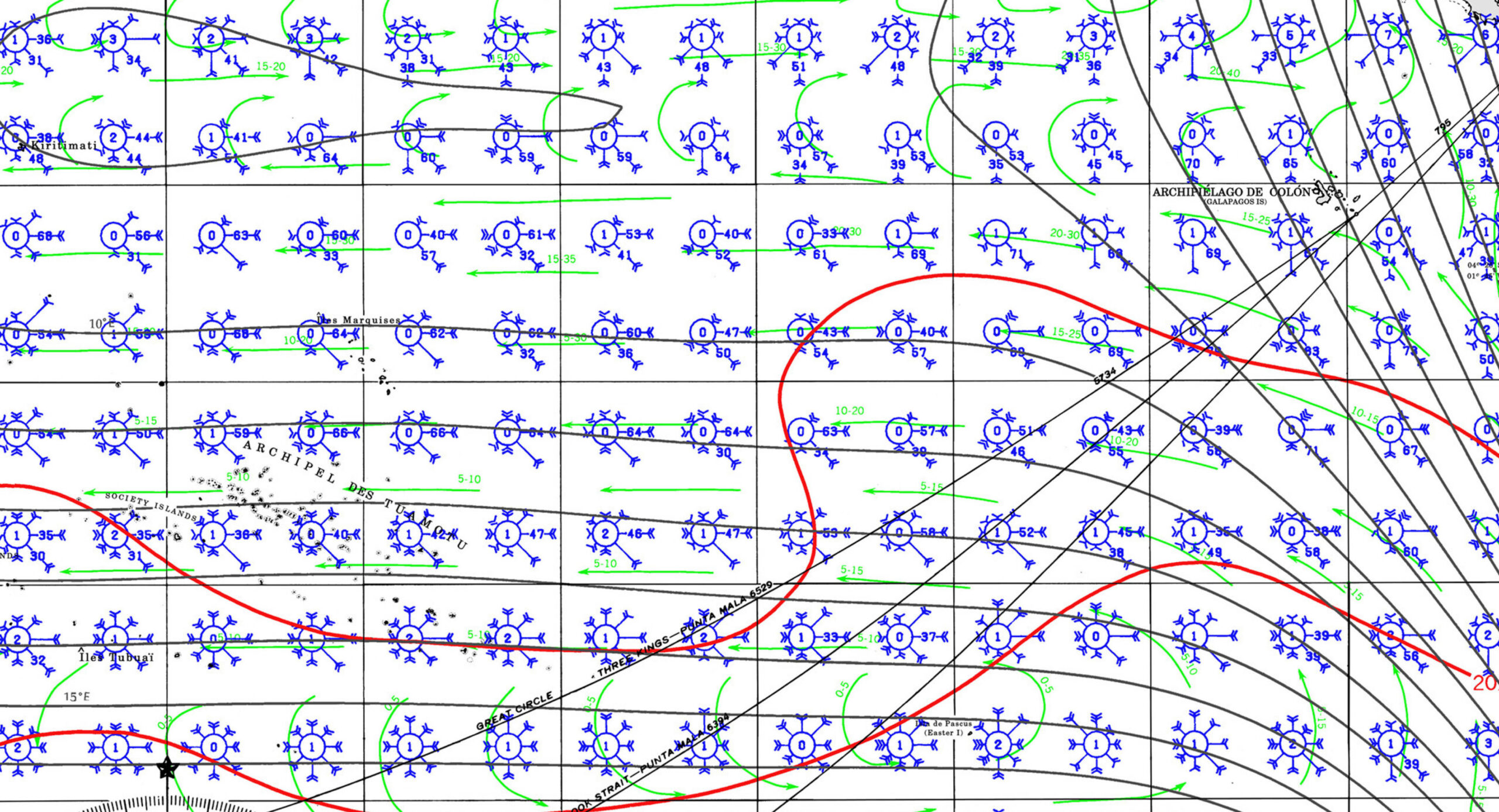
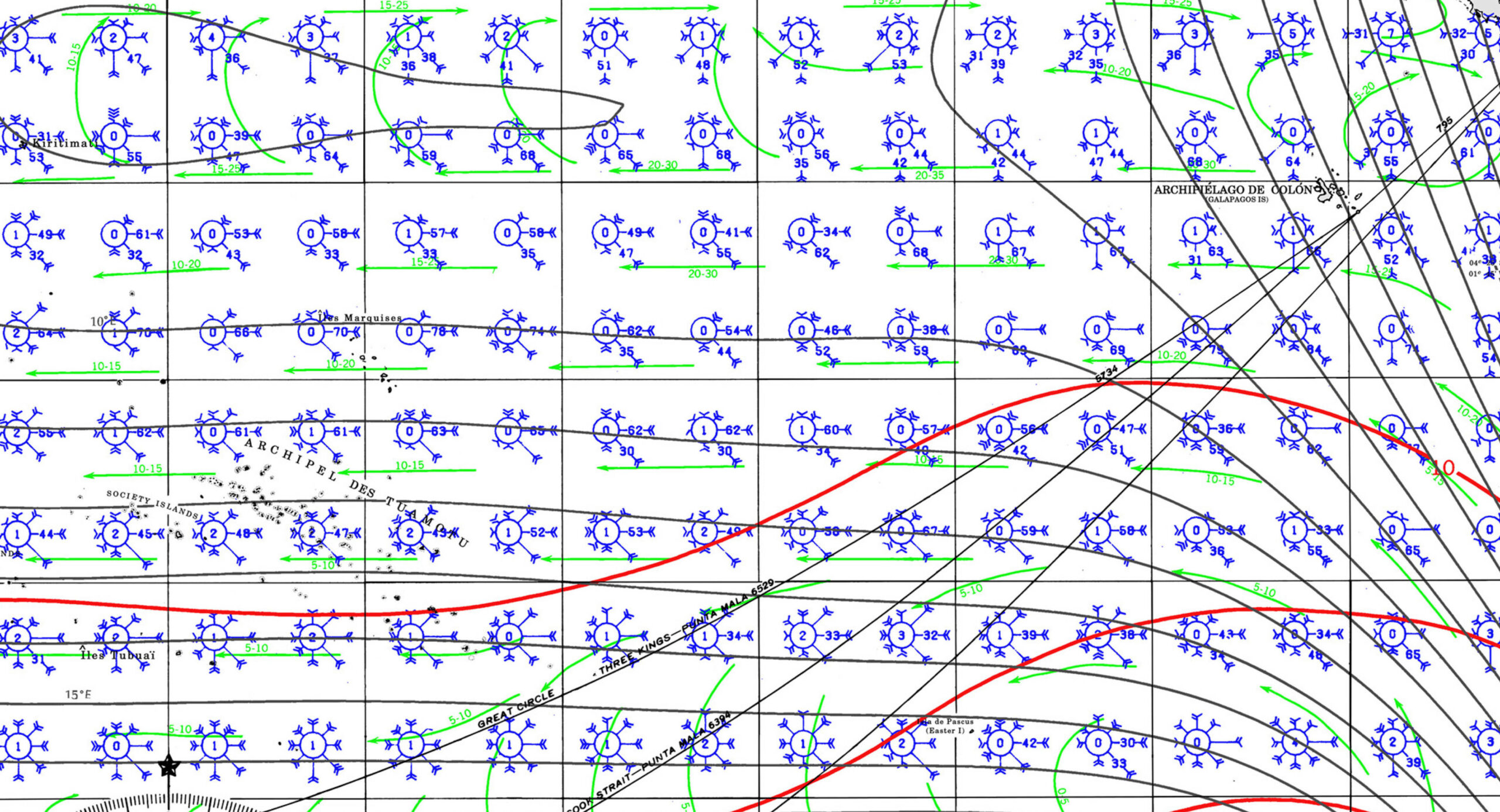
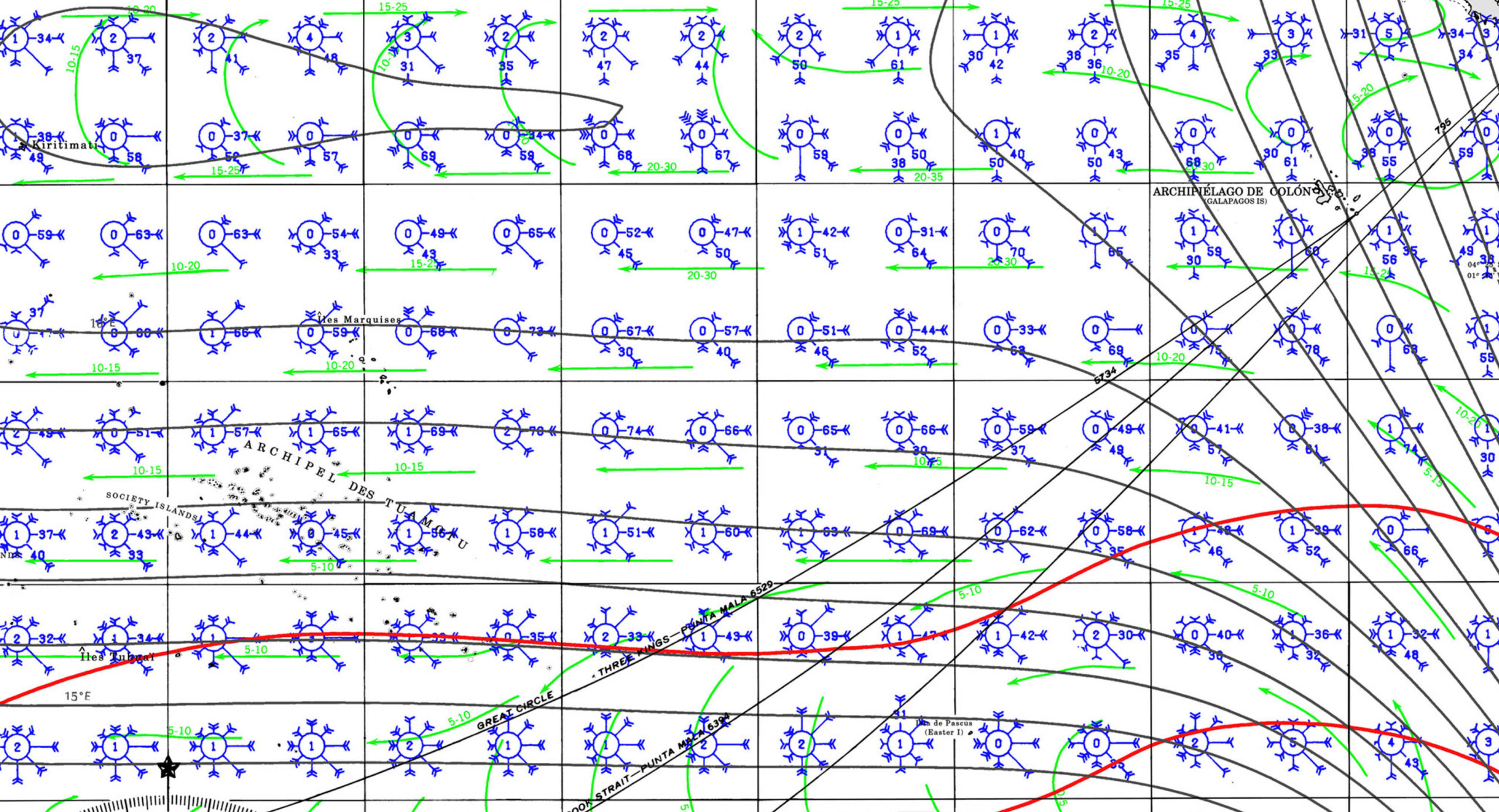
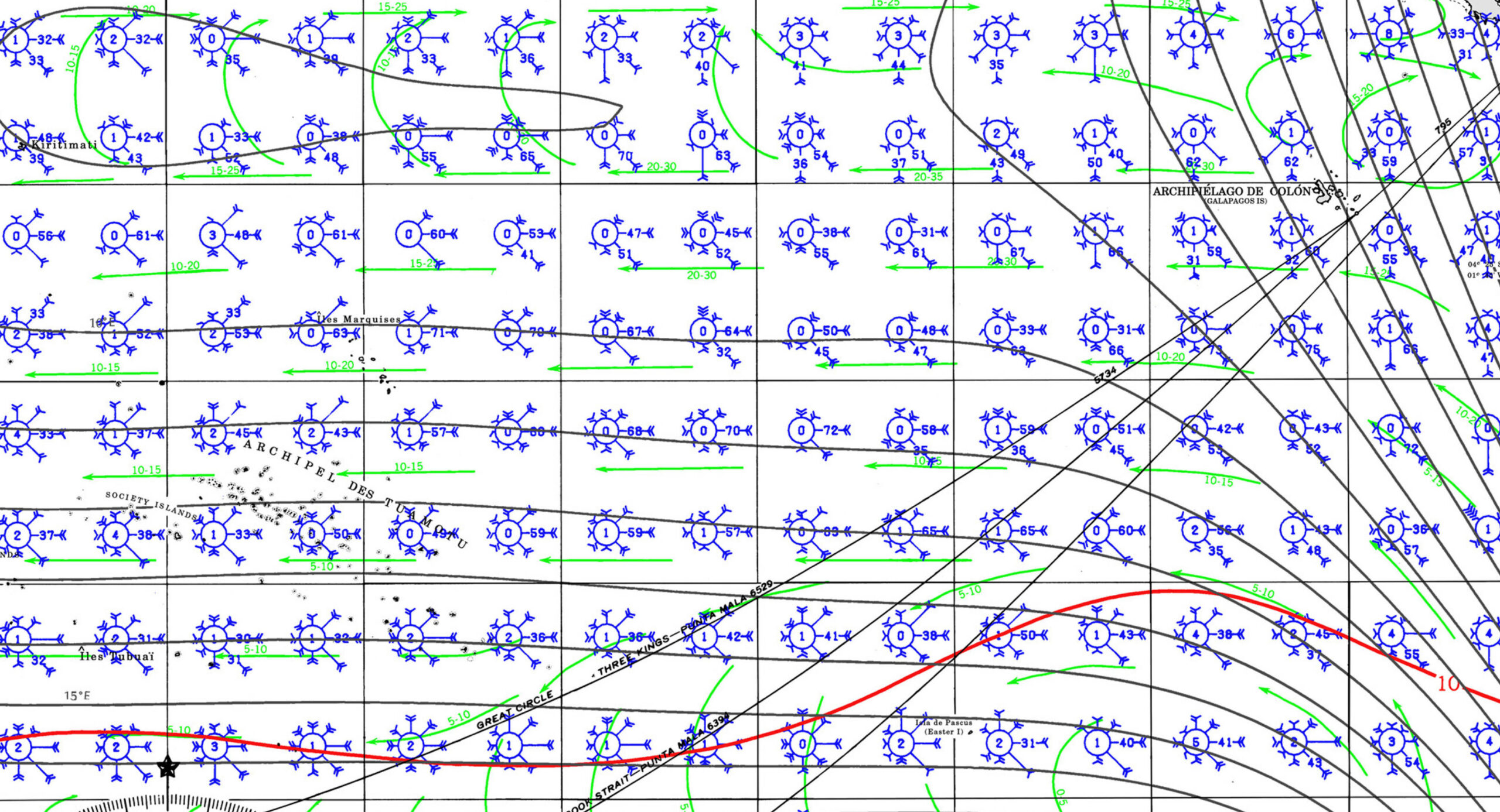
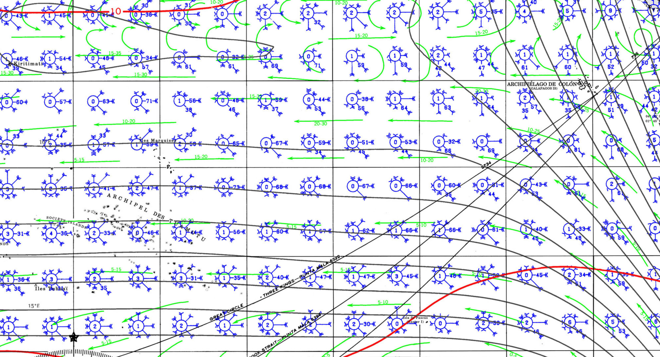
PORTS OF ENTRY
|
MARQUESAS
|
TUAMOTUS GAMBIERS |
AUSTRALS |
SOCIETY ISLANDS |
GAMBIERS |


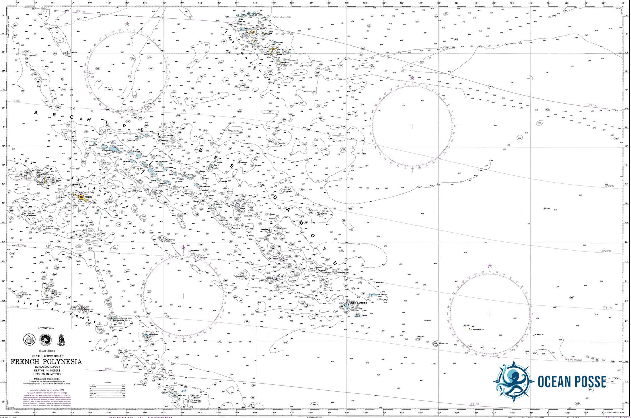


DOCUMENTS
ENTRY EXIT REQUIREMENTS
Yachts are cleared for 36 months without subject to Custom Duties –
Immigration however has 3 different categories .
US, UK, NZ, AUSTRALIANS and Canadians will get 90-day visas on arrival at their first landfall.
These CANNOT be extended in the islands. If you want to stay longer you need to file for a long stay visa ( and have it issued ) before you arrive .
French Polynesia is not part of the EU (via France) or Schengen Area, but facilitated regulations are applied to these countries’ citizens.
EU and Schengen countries’ nationals can travel to French Polynesia for an unlimited time period.
The FF have announced new requirements for long stay visas including this little gem !
If you are a US citizen and have your heart set on a LSV ( long stay visa ) we strongly encourage you to re-consider.
Here is their latest form to get your LSV with associated costs >>
Yachts clear in or out of FP with the “gendarmes” offices at the ports of entry. Immigration formalities will be processed by these Gendarmes. Registration can be done by e-mail. Document F09.01 Avis d’Opération Nautique Petite Plaisance sent to:
trafficmaritime@portppt.pf cc sp@portppt.pf cc marinadepapeete@portppt.pf
Customs declaration is legally binding and the customs boat monitors and inspects boats throughout the islands
checking for infringements on arms, drugs, alcohol, prescription medicines and pearls
Upon clearing you are allowed to cruise all of FP except for Tahiti where you must check in with the Harbormaster.
MUST SEE
- Mount Otemanu, Bora Bora
Latitude: -16.5004, Longitude: -151.7415
Dominating Bora Bora’s skyline, this peak offers panoramic views of the island and its famous lagoon. - Matira Beach, Bora Bora
Latitude: -16.5201, Longitude: -151.7417
Known as one of the world’s best beaches, with clear waters, white sand, and vibrant coral reefs nearby. - Marae Taputapuātea, Raiatea
Latitude: -16.8308, Longitude: -151.3653
A UNESCO World Heritage Site, this ancient ceremonial complex offers insight into Polynesian culture and spiritual practices. - Fautaua Waterfall, Tahiti
Latitude: -17.5333, Longitude: -149.5667
One of the tallest waterfalls in Polynesia, offering a rewarding hike through lush rainforest. - Point Venus, Tahiti
Latitude: -17.4934, Longitude: -149.4848
Historic landing site of Captain Cook with a black sand beach and historic lighthouse. - Moorea Lagoon, Moorea
Latitude: -17.5396, Longitude: -149.8295
Famous for snorkeling, this lagoon has a thriving marine ecosystem with stingrays and sharks. - Belvedere Lookout, Moorea
Latitude: -17.5381, Longitude: -149.8336
A stunning lookout point offering views over Cook’s Bay and Opunohu Bay. - Tetiaroa Atoll
Latitude: -17.0247, Longitude: -149.5663
Private island paradise known for luxurious resorts and pristine beaches. - Vaipahi Water Gardens, Tahiti
Latitude: -17.7648, Longitude: -149.2768
Beautiful botanical garden with waterfalls, indigenous plants, and scenic paths. - Blue Lagoon, Rangiroa
Latitude: -15.1364, Longitude: -147.6489
A natural pool with incredibly clear blue waters, perfect for snorkeling and diving. - Tiputa Pass, Rangiroa
Latitude: -14.9881, Longitude: -147.6249
A renowned diving spot with abundant marine life, including dolphins and sharks. - The Coral Church, Fakarava
Latitude: -16.0683, Longitude: -145.6217
A unique Catholic church built entirely from coral stone, symbolizing Fakarava’s UNESCO biosphere reserve. - Ahe Lagoon, Tuamotu Archipelago
Latitude: -14.4712, Longitude: -146.3841
A serene lagoon ideal for scuba diving, filled with colorful corals and fish species. - Anaa Atoll
Latitude: -17.3333, Longitude: -145.5167
Known for its pink sands and isolation, Anaa offers pristine beauty and cultural heritage. - Mount Rotui, Moorea
Latitude: -17.5208, Longitude: -149.8364
A challenging but scenic hike with rewarding views of Moorea’s two main bays. - Arahurahu Marae, Tahiti
Latitude: -17.5864, Longitude: -149.5649
A restored sacred site used for ancient Polynesian rituals, offering insight into Tahiti’s past. - Tahiti Iti Peninsula
Latitude: -17.7811, Longitude: -149.2472
Home to wild coastlines, surfing at Teahupo’o, and authentic Polynesian villages. - Huahine Lagoon, Huahine
Latitude: -16.7104, Longitude: -151.0334
A tranquil lagoon known for its relaxed vibe, clear waters, and traditional Polynesian lifestyle. - Tiki Village Cultural Center, Moorea
Latitude: -17.5506, Longitude: -149.8689
A cultural village showcasing Polynesian customs, dances, and traditional crafts. - Makatea Island
Latitude: -15.8333, Longitude: -148.2500
Known for its limestone cliffs, caves, and rare wildlife; ideal for ecotourism. - Tereia Beach, Maupiti
Latitude: -16.4824, Longitude: -152.2543
A secluded beach with stunning views of Mount Teurafaatiu and a shallow sandbank to wade across. - Rurutu Caves, Austral Islands
Latitude: -22.4429, Longitude: -151.3635
Ancient limestone caves with remarkable stalactites, stalagmites, and archaeology. - Anakena Beach, Easter Island
Latitude: -27.0700, Longitude: -109.3274
Known for its white sands and iconic Moai statues, merging Polynesian and Rapa Nui culture. - Bora Bora Lagoonarium, Bora Bora
Latitude: -16.4843, Longitude: -151.7000
A marine park where visitors can snorkel with rays, turtles, and tropical fish.
REPAIRS AND SERVICE PROVIDERS
REPAIRS AND SERVICE PROVIDERS
- Technimarine
Location: Papeete, Tahiti
Technimarine is a well-established shipyard offering full-service repairs and maintenance, including haul-out facilities, hull repairs, painting, and custom fabrication. - NautiSport
Location: Papeete, Tahiti
Known for its comprehensive range of marine supplies, NautiSport stocks everything from navigational gear and diving equipment to water sports accessories. They also provide rigging services and installation. - STP Marine Tahiti
Location: Papeete, Tahiti
STP Marine specializes in engine repairs, electrical work, and maintenance, serving yachts and smaller vessels. They offer both in-shop and mobile services to boats across the islands. - Sail Tech Tahiti
Location: Marina Taina, Tahiti
Sail Tech provides top-notch sail repairs, rigging services, and custom sail creation. Known for their quality service, they cater to yachts and superyachts in French Polynesia. - Hiva Oa Yacht Services
Location: Atuona, Hiva Oa (Marquesas Islands)
Serving the more remote Marquesas Islands, Hiva Oa Yacht Services offers a range of basic maintenance services, provisioning, and emergency repairs for boats in transit. - Tahiti Crew
Location: Papeete, Tahiti
A full-service agency, Tahiti Crew handles yacht management, crew services, logistics, and customs clearance. They specialize in high-end, tailored support for luxury vessels. - Polynesia Yacht Services
Location: Tahiti and Moorea
Offering concierge services, Polynesia Yacht Services assists with provisioning, customs, and spare parts sourcing. They cater to yachts visiting Tahiti and the Society Islands. - Apogee Marine
Location: Tahiti
Specialized in electronics and communication systems, Apogee Marine provides GPS, radar, and satellite installation and repair, serving both leisure and commercial vessels. - Tahiti Yacht Repair
Location: Marina Taina, Tahiti
Known for their mechanical and engine services, Tahiti Yacht Repair also handles hull cleaning, bottom painting, and interior refurbishments for both small and large yachts. - Yacht Services Nuku Hiva
Location: Taiohae Bay, Nuku Hiva (Marquesas Islands)
This service center provides logistics, provisioning, and repair assistance to yachts in the Marquesas, a crucial stopover for vessels crossing the Pacific. - Apataki Carenage for inquiries or to arrange services, you can contact Apataki Carenage via email at apatakicarenageservices@gmail.com or by phone at 87 71 61 39 or 87 72 78 13
- Raiatea Carenage is a well-known boatyard and maintenance facility located on Raiatea Island in French Polynesia. It offers a range of services to yachts and larger vessels, including haul-out, storage, and repair services. As the largest service hub for marine needs in the Society Islands, Raiatea Carenage is particularly popular among sailors preparing for long voyages or needing essential maintenance after extensive sailing in the South Pacific.

EMERGENCIES AND SAR INFO
Liste des Centres de Santé / List of health care centers :
- Tahiti
Institut Louis Malardé, Rue du 5 mars 1797 (en face de Tahiti Pas Cher, Paofai), Papeete –
Tel: (+689) 40 416 459.
Ouvert du lundi au vendredi de
07h30 à 15h00, samedi et dimanche de 07h30 à 12h00 /
Open from Monday to Friday from 7:30am to 3pm, Saturday and Sunday from 7:30am to noonHôpital de Taravao, PK 60, Taravao –
Tel: (+689) 40 547 782.
Ouvert du lundi au jeudi de 7h30 à 15h30, le vendredi de 7h30 à 14h30 /
Open from
Monday to Thursday 7:30am to 3:30pm, Friday from 7:30am to 2:30pm - Moorea
Hôpital d’Afareaitu –
Tel: (+689) 40 552 222.
Ouvert du lundi au jeudi de 7h00 à 15h00, le vendredi de 7h00 à 14h00 /
Open from Monday to Thursday
7am to 3pm, Friday from 7am to 2pm - Raiatea
Hôpital d’Uturoa –
Tel: (+689) 40 600 800.
Ouvert du lundi au jeudi de 7h30 à 15h30, le vendredi de 7h30 à 14h30 /
Open from Monday to Thursday
7:30am to 3:30pm, Friday from 7:30am to 2:30pm - Tahaa
Centre médical –
Tel: (+689) 40 656 331.
Ouvert du lundi au jeudi de 7h30 à 15h30, le vendredi de 7h30 à 14h30 /
Open from Monday to Thursday
7:30am to 3:30pm, Friday from 7:30am to 2:30pmCentre médical, mairie de Haamene, côté mer –
Tel: (+689) 40 656 751.
Ouvert le mardi de 7h30 à 12h00 /
Open on Tuesday from 7:30am to
12:00am - Huahine
Dispensaire, face à la gendarmerie de Fare –
Tel: (+689) 40 688 248.
Ouvert du lundi au jeudi de 7h30 à 15h30, le vendredi de 7h30 à 14h30 /
Open
from Monday to Thursday 7:30am to 3:30pm, Friday from 7:30am to 2:30pm - Bora Bora
Dispensaire, devant l’école de Namaha, à 1 km du centre de Vaitape –
Tel: (+689) 40 677 077.
Ouvert du lundi au jeudi de 7h30 à 15h30, le vendredi
de 7h30 à 14h30 /
Open from Monday to Thursday 7:30am to 3:30pm, Friday from 7:30am to 2:30pm - Maupiti
Infirmerie, côté mer, Farauru –
Tel: (+689) 40 678 018.
Ouvert du lundi au jeudi de 7h30 à 15h30, le vendredi de 7h30 à 14h30 /
Open from Monday
to Thursday 7:30am to 3:30pm, Friday from 7:30am to 2:30pm - Nuku Hiva
Hôpital Taiohae –
Tel: (+689) 40 910 200.
Ouvert du lundi au jeudi de 7h30 à 15h30, le vendredi de 7h30 à 14h30 /
Open from Monday to Thursday
7:30am to 3:30pm, Friday from 7:30am to 2:30pmInfirmerie de Taipivai –
Tel: (+689) 40 920 142.
Ouvert du lundi au vendredi de 7h30 à 13h30 /
Open from Monday to Friday 7:30am to 1:30pmInfirmerie de Hatiheu –
Tel: (+689) 40 920 143.
Ouvert du lundi au vendredi de 7h30 à 13h30 /
Open from Monday to Friday 7:30am to 1:30pm - Ua Huka
Infirmerie de Hane –
Tel: (+689) 40 926 058.
Ouvert du lundi au vendredi de 7h30 à 13h30 /
Open from Monday to Friday 7:30am to 1:30pm - Ua Pou
Centre médical de Hakahau –
Tel: (+689) 40 925 375.
Ouvert du lundi au jeudi de 7h30 à 15h30, le vendredi de 7h30 à 14h30 /
Open from Monday
to Thursday 7:30am to 3:30pm, Friday from 7:30am to 2:30pmInfirmerie de Hakamaii –
Tel: (+689) 40 925 299.
Ouvert du lundi au vendredi de 7h30 à 13h30 /
Open from Monday to Friday 7:30am to 1:30pmInfirmerie de Hakatao –
Tel: (+689) 40 925 104.
Ouvert du lundi au vendredi de 7h30 à 13h30 /
Open from Monday to Friday 7:30am to 1:30pm - Hiva Oa
Centre médical de Atuona –
Tel: (+689) 40 927 375.
Ouvert du lundi au jeudi de 7h30 à 15h30, le vendredi de 7h30 à 14h30 /
Open from Monday to
Thursday 7:30am to 3:30pm, Friday from 7:30am to 2:30pmInfirmerie de Paumau –
Tel: (+689) 40 927 496.
Ouvert du lundi au vendredi de 7h30 à 13h30 /
Open from Monday to Friday 7:30am to 1:30pm - Tahuata
Infirmerie de Vaitahu –Tel : (+689) 40 929 227.
Ouvert du lundi au vendredi de 7h30 à 13h30 /
Open from Monday to Friday 7:30am to 1:30pm - Fatu Hiva
Infirmerie de Omoa –
Tel: (+689) 40 928 036.
Ouvert du lundi au vendredi de 7h30 à 13h30 /
Open from Monday to Friday 7:30am to 1:30pm - Tubuai
Centre médical de Mataura –
Tel: (+689) 40 932 250.
Ouvert du lundi au jeudi de 7h30 à 15h30, le vendredi de 7h30 à 14h30 /
Open from Monday to
Thursday 7:30am to 3:30pm, Friday from 7:30am to 2:30pm - Rurutu
Centre médical de Moerai –
Tel: (+689) 40 930 440.
Ouvert du lundi au jeudi de 7h30 à 15h30, le vendredi de 7h30 à 14h30 /
Open from Monday to
Thursday 7:30am to 3:30pm, Friday from 7:30am to 2:30pm - Rimatara
Infirmerie de Amaru –
Tel: (+689) 40 944 270.
Ouvert du lundi au jeudi de 7h30 à 15h30, le vendredi de 7h30 à 14h30 /
Open from Monday to
Thursday 7:30am to 3:30pm, Friday from 7:30am to 2:30pm - Raivavae
Infirmerie de Rairua –
Tel: (+689) 40 95 42 31.
Ouvert du lundi au jeudi de 7h30 à 15h30, le vendredi de 7h30 à 14h30 /
Open from Monday to
Thursday 7:30am to 3:30pm, Friday from 7:30am to 2:30pm - Rangiroa
Centre médical de Avatoru –
Tel: (+689) 40 960 325.Infirmerie de Tiputa –
Tel: (+689) 40 967 396.
Ouvert du lundi au vendredi de 07h30 à 12h00. Urgences 24 heures/24 et 7 jours/7 /
Open from Monday
to Friday 7:30am to 12:00am. Emergency 24h/24, everyday - Hao
Centre médical –
Tel: (+689) 40 970 513. - Makemo
Centre médical , près du phare –
Tel: (+689) 40 980 325.
Ouvert du lundi au jeudi de 7h30 à 15h30, le vendredi de 7h30 à 14h30 /
Open from
Monday to Thursday 7:30am to 3:30pm, Friday from 7:30am to 2:30pmInfirmerie –
Tel: (+689) 40 980 325.
Ouvert du lundi au vendredi de 07h30 à 12h00. Urgences 24 heures/24 et 7 jours/7 /
Open from Monday to Friday
7:30am to 12:00am. Emergency 24h/24, everyday - Gambier
Centre médical de Rikitea, face à la gendarmerie –
Tel: (+689) 40 978 216.
Ouvert du lundi au jeudi de 7h30 à 15h30, le vendredi de 7h30 à 14h30 /Open from Monday to Thursday 7:30am to 3:30pm, Friday from 7:30am to 2:30pm - Ahe
Infirmerie, village de Tenukupara –
Tel: (+689) 40 964 403.
Ouvert du lundi au vendredi de 07h30 à 12h00. Urgences 24 heures/24 et 7 jours/7 /
Open
from Monday to Friday 7:30am to 12:00am. Emergency 24h/24, everyday - Anaa
Infirmerie, village de Tuuhora –
Tel: (+689) 40 983 204.
Ouvert du lundi au vendredi de 07h30 à 12h00. Urgences 24 heures/24 et 7 jours/7 /
Open
from Monday to Friday 7:30am to 12:00am. Emergency 24h/24, everyday - Arutua
Infirmerie, village de Rautini –
Tel: (+689) 40 965 300.
Ouvert du lundi au vendredi de 07h30 à 12h00. Urgences 24 heures/24 et 7 jours/7 /
Open from
Monday to Friday 7:30am to 12:00am. Emergency 24h/24, everyday - Fakarava
Infirmerie –
Tel: (+689) 40 984 224.
Ouvert du lundi au vendredi de 07h30 à 12h00. Urgences 24 heures/24 et 7 jours/7 /
Open from Monday to Friday
7:30am to 12:00am. Emergency 24h/24, everydayInfirmerie, mairie de Rotoava –
Tel: (+689) 40 984 224.
Ouvert du lundi au vendredi de 07h30 à 12h00. Urgences 24 heures/24 et 7 jours/7 /
Open
from Monday to Friday 7:30am to 12:00am. Emergency 24h/24, everyday - Manihi
Infirmerie, Turipaoa, à côté de la mairie –
Tel: (689) 40 964 136.
Ouvert du lundi au vendredi de 07h30 à 12h00. Urgences 24 heures/24 et 7 jours/7 /Open from Monday to Friday 7:30am to 12:00am. Emergency 24h/24, everyday - Napuka
Infirmerie, village de Tepukamaruia –Tel : (+689) 40 973 260.
Ouvert du lundi au vendredi de 07h30 à 12h00. Urgences 24 heures/24 et 7 jours/7 /Open from Monday to Friday 7:30am to 12:00am. Emergency 24h/24, everyday - Reao
Infirmerie, village de Tapuarava –
Tel: (+689) 40 969 041.
Ouvert du lundi au vendredi de 07h30 à 12h00. Urgences 24 heures/24 et 7 jours/7 /
Open
from Monday to Friday 7:30am to 12:00am. Emergency 24h/24, everyday - Takapoto
Infirmerie, village de Fakatopatere –
Tel: (+689) 40 986 486.
Ouvert du lundi au vendredi de 07h30 à 12h00. Urgences 24 heures/24 et 7 jours/7 /Open from Monday to Friday 7:30am to 12:00am. Emergency 24h/24, everyday - Takaroa
Infirmerie, près de la mairie –
Tel: (+689) 40 982 263.
Ouvert du lundi au vendredi de 07h30 à 12h00. Urgences 24 heures/24 et 7 jours/7 /
Open from
Monday to Friday 7:30am to 12:00am. Emergency 24h/24, everyday - Tikehau
Infirmerie, village de Tuherahera –
Tel: (+689) 40 962 349.
Ouvert du lundi au vendredi de 07h30 à 12h00. Urgences 24 heures/24 et 7 jours/7 /
Open
from Monday to Friday 7:30am to 12:00am. Emergency 24h/24, everyday

GUADELOUPE 🇬🇵 CRUISING THE CARIBBEAN WITH THE OCEAN POSSE
🇬🇵 GUADELOUPE
 Guadeloupe, a French overseas territory nestled in the heart of the Caribbean, is a cruising paradise that blends the charm of the French Riviera with the allure of the Caribbean. From the twin main islands of Grande-Terre and Basse-Terre to the idyllic Îles des Saintes and La Désirade, Guadeloupe offers an array of experiences for cruisers, making it an essential stop on any Caribbean sailing itinerary.
A Diverse Archipelago
The archipelago of Guadeloupe is shaped like a butterfly, with Grande-Terre on the east and Basse-Terre on the west. Each of these islands offers a unique cruising experience. Grande-Terre is known for its white sandy beaches, rolling sugarcane fields, and lively towns, while Basse-Terre is more rugged, with volcanic peaks, lush rainforests, and cascading waterfalls. The smaller surrounding islands, like Îles des Saintes, Marie-Galante, and La Désirade, provide secluded anchorages and a more laid-back atmosphere, perfect for cruisers looking to escape the crowds.
Approaching Guadeloupe
As you approach Guadeloupe, the towering La Soufrière volcano on Basse-Terre dominates the skyline. The first decision a cruiser must make is whether to approach from the Atlantic side or the Caribbean side. The Caribbean side, west of Basse-Terre, is generally calmer and offers better protection, making it the preferred route for many cruisers. The windward side, on the east of Grande-Terre, can be more challenging due to the prevailing trade winds and stronger currents.
Marinas and Anchorages
Guadeloupe is well-equipped with marinas and anchorages, catering to both luxury yachts and modest sailboats.
- Marina Bas-du-Fort (Pointe-à-Pitre): This is the largest marina in Guadeloupe and a key hub for cruisers. Located near the bustling city of Pointe-à-Pitre, Marina Bas-du-Fort offers over 1,000 berths, complete with modern facilities such as fuel, water, electricity, Wi-Fi, and security. It’s an ideal place to restock, repair, and enjoy some urban comforts before heading out to explore the rest of the archipelago.
- Port de Plaisance de Rivière-Sens (Basse-Terre): Situated on the quieter Basse-Terre, this marina offers a more tranquil experience with around 350 berths. It’s an excellent base for exploring Basse-Terre’s natural attractions, such as the Guadeloupe National Park and La Soufrière volcano.
- Marina de Saint-François: On the eastern tip of Grande-Terre, this marina is perfect for cruisers heading to or from La Désirade or the Îles des Saintes. It’s a vibrant spot with a lively market, excellent restaurants, and close proximity to beautiful beaches.
- Îles des Saintes Anchorages: Terre-de-Haut in Îles des Saintes is renowned for its crystal-clear waters and picturesque bay, which is considered one of the most beautiful in the world. The anchorages here are well-protected, and the island itself offers charming streets, historic sites like Fort Napoléon, and delightful French-Caribbean cuisine.
Sailing Conditions
Guadeloupe benefits from the consistent trade winds typical of the Caribbean, generally blowing from the east at 15-20 knots. These winds make for excellent sailing conditions, especially along the leeward side of Basse-Terre. However, the windward side can be more challenging, with stronger winds and currents.
The waters around Guadeloupe are mostly deep, making navigation straightforward, but attention should be paid to the reefs, particularly around the smaller islands and the Atlantic side of Grande-Terre. Charts are reliable, but as always in the Caribbean, local knowledge is invaluable, particularly when navigating near coral reefs or during squalls.
Cultural Immersion
One of the delights of cruising Guadeloupe is the chance to immerse yourself in the vibrant blend of French and Creole cultures. Pointe-à-Pitre is the cultural heart of Guadeloupe, where you can stroll through colorful markets, sample local dishes like bokit (a type of sandwich) and accras (fried fish cakes), and enjoy the lively music scene, especially during Carnival.
The smaller towns and villages, such as Deshaies on Basse-Terre and Saint-François on Grande-Terre, offer a more laid-back vibe, with plenty of opportunities to interact with friendly locals, explore quaint streets, and enjoy the slower pace of life that is characteristic of the Caribbean.
Natural Wonders
Guadeloupe is a nature lover’s dream. Basse-Terre, in particular, offers some of the most diverse landscapes in the Caribbean. The Guadeloupe National Park is home to the towering La Soufrière volcano, lush rainforests, and numerous hiking trails leading to stunning waterfalls like Chute du Carbet. For those who prefer the underwater world, the Cousteau Reserve off the coast of Basse-Terre is a must-see. This marine reserve is one of the best diving spots in the Caribbean, with vibrant coral reefs, sea turtles, and a dazzling array of tropical fish.
Grande-Terre, with its rolling plains and sandy beaches, is perfect for beachcombing and kite surfing, particularly around the southeastern coast near Pointe des Châteaux. Meanwhile, the smaller islands like Marie-Galante and La Désirade offer a more rustic, unspoiled experience, with deserted beaches, small fishing villages, and a strong sense of tradition.
Provisioning and Supplies
Guadeloupe offers excellent provisioning opportunities, especially in Pointe-à-Pitre and Basse-Terre. The French influence is evident in the availability of high-quality wines, cheeses, and gourmet foods, which are a delight for any cruiser looking to stock up. Local markets are also abundant, offering fresh fruits, vegetables, seafood, and a taste of Creole cuisine.
Marine supplies are readily available at the main marinas, with a range of services including repairs, chandlery, and refueling. However, it’s always wise to ensure you have essential spares and equipment before embarking on longer passages, especially if heading to more remote islands like La Désirade or Îles des Saintes.
Best Time to Visit
The best time to cruise Guadeloupe is during the dry season, from December to April. During this period, the weather is warm and stable, with less chance of rain and lower humidity. The trade winds are also consistent, making for excellent sailing conditions. Hurricane season runs from June to November, with the highest risk between August and October. While Guadeloupe has modern hurricane facilities, it’s advisable to avoid cruising during this time unless you have a secure plan in place.
MARINAS
1. Marina Bas-du-Fort
- Location: 16°12.894′ N, 61°31.548′ W
- Description: Marina Bas-du-Fort is the largest marina in Guadeloupe, located in Pointe-à-Pitre, making it an essential hub for yachts navigating the Caribbean. This well-equipped marina offers 1,000 berths, accommodating vessels up to 40 meters in length with a maximum draft of 5 meters. The marina provides a full range of services including fuel, water, electricity, Wi-Fi, laundry facilities, and repair services. Several restaurants, shops, and a chandlery are located within the marina complex. The proximity to the city of Pointe-à-Pitre means easy access to additional amenities such as supermarkets, pharmacies, and cultural attractions.
- Contact Info:
- Phone: +590 590 90 98 80
- Email: contact@marinabasdufort.com
- Website: marinabasdufort.com
2. Marina Rivière Sens
- Location: 15°58.404′ N, 61°42.132′ W
- Description: Marina Rivière Sens is located on the southern coast of Basse-Terre, offering 360 berths for boats up to 30 meters in length. This marina is particularly appealing for those looking to explore the natural beauty of Basse-Terre, including the nearby Soufrière volcano and the pristine beaches. The marina features modern amenities such as fuel, water, electricity, Wi-Fi, and a shipyard for repairs. Several dining options and shops are available nearby, making it a convenient stop for both short-term and long-term stays.
- Contact Info:
- Phone: +590 590 99 22 22
- Email: marina.rivieresens@orange.fr
3. Marina Saint-François
- Location: 16°15.255′ N, 61°16.972′ W
- Description: Marina Saint-François is located on the eastern tip of Grande-Terre, providing 250 berths for yachts up to 25 meters in length. Known for its vibrant atmosphere, the marina is close to the lively town of Saint-François, where visitors can enjoy local markets, restaurants, and shops. The marina offers essential services including fuel, water, electricity, and Wi-Fi. Its strategic location makes it an excellent departure point for excursions to the nearby islands of La Désirade, Marie-Galante, and Les Saintes.
- Contact Info:
- Phone: +590 590 88 41 08
- Email: capitainerie@mairie-saintfrancois.fr
4. Marina Port de Plaisance de Deshaies
- Location: 16°18.487′ N, 61°47.309′ W
- Description: Situated on the northwest coast of Basse-Terre, Marina Port de Plaisance de Deshaies offers a more intimate setting with 80 berths for yachts up to 20 meters. The marina is nestled in a picturesque bay, famous for its role in the television series “Death in Paradise.” Deshaies is a quaint village known for its beautiful botanical garden and pristine beaches. The marina provides basic amenities including water, electricity, and fuel. It’s a perfect spot for those seeking a quiet and scenic retreat.
- Contact Info:
- Phone: +590 590 28 42 31
- Email: port.de.plaisance.deshaies@orange.fr
5. Port de Plaisance de Pointe-à-Pitre (Môle Portuaire)
- Location: 16°14.245′ N, 61°31.670′ W
- Description: Located in the heart of Pointe-à-Pitre, Port de Plaisance de Pointe-à-Pitre, also known as Môle Portuaire, offers limited berthing for yachts visiting the city. This marina is more basic compared to others in the region but provides essential services for yachts needing a short stay while visiting the commercial and cultural center of Guadeloupe. The proximity to local markets, shops, and restaurants makes it convenient for those looking to explore the city.
- Contact Info:
- Phone: +590 590 93 41 88
- Email: portuaire.pointeapitre@guadeloupe.fr
These marinas offer a range of services and facilities that cater to different needs, whether you’re seeking a full-service marina with extensive amenities or a quieter, more scenic location.
6. Marina de la Darse
- Location: 16°13.830′ N, 61°32.134′ W
- Description: Located in Pointe-à-Pitre, Marina de la Darse is a smaller and more traditional marina compared to Bas-du-Fort. It offers berthing for smaller yachts and is often used by local fishermen. This marina has basic facilities such as water and electricity and is well-situated for those looking to explore the bustling town of Pointe-à-Pitre.
- Contact Info:
- Phone: +590 590 83 00 62
7. Port de Plaisance de Gosier
- Location: 16°12.222′ N, 61°29.467′ W
- Description: Located in the popular tourist area of Le Gosier, this marina is a favorite among sailors looking for a lively spot with plenty of restaurants, bars, and shops nearby. It offers essential services like water, electricity, and fuel and is a good starting point for exploring the southern coast of Grande-Terre.
- Contact Info:
- Phone: +590 590 85 10 20
8. Port de Plaisance de Petit-Bourg
- Location: 16°10.621′ N, 61°35.217′ W
- Description: This marina is located in Petit-Bourg, offering a quieter alternative for those seeking refuge from the busier ports. The marina provides basic amenities and is well-positioned for exploring the natural beauty of the surrounding area, including waterfalls and lush rainforests.
- Contact Info:
- Phone: +590 590 95 08 12
9. Port de Plaisance de Baie-Mahault
- Location: 16°15.822′ N, 61°34.295′ W
- Description: This small marina in Baie-Mahault caters mainly to local boats and smaller yachts. It offers limited facilities but is conveniently located near the commercial center of Jarry, making it a good stop for provisioning and repairs.
- Contact Info:
- Phone: +590 590 26 59 59
10. Port de Plaisance de Marie-Galante (Grand-Bourg)
- Location: 15°52.612′ N, 61°19.508′ W
- Description: Located on the island of Marie-Galante, this marina offers a picturesque setting with basic facilities. It’s a great spot for those looking to explore this lesser-visited island, known for its sugar cane fields and traditional rum distilleries.
- Contact Info:
- Phone: +590 590 97 55 55
11. Port de Plaisance de Les Saintes (Terre-de-Haut)
- Location: 15°52.967′ N, 61°35.514′ W
- Description: Situated on the idyllic island of Terre-de-Haut in Les Saintes, this small marina provides a charming stopover for yachts. With stunning views and a tranquil atmosphere, it’s a favorite among those seeking a serene and beautiful spot. The marina offers basic amenities like water and electricity.
- Contact Info:
- Phone: +590 590 99 50 21
12. Mouillage de Deshaies
- Location: 16°18.295′ N, 61°47.612′ W
- Description: While not a marina, the anchorage at Deshaies is a popular mooring spot for yachts, providing a safe and scenic location for overnight stays. The village of Deshaies offers access to essential services, and the anchorage is well-known for its calm waters and beautiful surroundings.
- Contact Info: No formal contact; anchorage is first-come, first-served.
WEATHER
MAIN LOCAL WEATHER WEBSITE /span>
SEVERE WEATHER GUADELOUPE
PILOT CHARTS
PORTS OF ENTRY
🇬🇵 GUADELOUPE
Guadeloupe, a French overseas territory nestled in the heart of the Caribbean, is a cruising paradise that blends the charm of the French Riviera with the allure of the Caribbean. From the twin main islands of Grande-Terre and Basse-Terre to the idyllic Îles des Saintes and La Désirade, Guadeloupe offers an array of experiences for cruisers, making it an essential stop on any Caribbean sailing itinerary.
A Diverse Archipelago
The archipelago of Guadeloupe is shaped like a butterfly, with Grande-Terre on the east and Basse-Terre on the west. Each of these islands offers a unique cruising experience. Grande-Terre is known for its white sandy beaches, rolling sugarcane fields, and lively towns, while Basse-Terre is more rugged, with volcanic peaks, lush rainforests, and cascading waterfalls. The smaller surrounding islands, like Îles des Saintes, Marie-Galante, and La Désirade, provide secluded anchorages and a more laid-back atmosphere, perfect for cruisers looking to escape the crowds.
Approaching Guadeloupe
As you approach Guadeloupe, the towering La Soufrière volcano on Basse-Terre dominates the skyline. The first decision a cruiser must make is whether to approach from the Atlantic side or the Caribbean side. The Caribbean side, west of Basse-Terre, is generally calmer and offers better protection, making it the preferred route for many cruisers. The windward side, on the east of Grande-Terre, can be more challenging due to the prevailing trade winds and stronger currents.
Marinas and Anchorages
Guadeloupe is well-equipped with marinas and anchorages, catering to both luxury yachts and modest sailboats.
- Marina Bas-du-Fort (Pointe-à-Pitre): This is the largest marina in Guadeloupe and a key hub for cruisers. Located near the bustling city of Pointe-à-Pitre, Marina Bas-du-Fort offers over 1,000 berths, complete with modern facilities such as fuel, water, electricity, Wi-Fi, and security. It’s an ideal place to restock, repair, and enjoy some urban comforts before heading out to explore the rest of the archipelago.
- Port de Plaisance de Rivière-Sens (Basse-Terre): Situated on the quieter Basse-Terre, this marina offers a more tranquil experience with around 350 berths. It’s an excellent base for exploring Basse-Terre’s natural attractions, such as the Guadeloupe National Park and La Soufrière volcano.
- Marina de Saint-François: On the eastern tip of Grande-Terre, this marina is perfect for cruisers heading to or from La Désirade or the Îles des Saintes. It’s a vibrant spot with a lively market, excellent restaurants, and close proximity to beautiful beaches.
- Îles des Saintes Anchorages: Terre-de-Haut in Îles des Saintes is renowned for its crystal-clear waters and picturesque bay, which is considered one of the most beautiful in the world. The anchorages here are well-protected, and the island itself offers charming streets, historic sites like Fort Napoléon, and delightful French-Caribbean cuisine.
Sailing Conditions
Guadeloupe benefits from the consistent trade winds typical of the Caribbean, generally blowing from the east at 15-20 knots. These winds make for excellent sailing conditions, especially along the leeward side of Basse-Terre. However, the windward side can be more challenging, with stronger winds and currents.
The waters around Guadeloupe are mostly deep, making navigation straightforward, but attention should be paid to the reefs, particularly around the smaller islands and the Atlantic side of Grande-Terre. Charts are reliable, but as always in the Caribbean, local knowledge is invaluable, particularly when navigating near coral reefs or during squalls.
Cultural Immersion
One of the delights of cruising Guadeloupe is the chance to immerse yourself in the vibrant blend of French and Creole cultures. Pointe-à-Pitre is the cultural heart of Guadeloupe, where you can stroll through colorful markets, sample local dishes like bokit (a type of sandwich) and accras (fried fish cakes), and enjoy the lively music scene, especially during Carnival.
The smaller towns and villages, such as Deshaies on Basse-Terre and Saint-François on Grande-Terre, offer a more laid-back vibe, with plenty of opportunities to interact with friendly locals, explore quaint streets, and enjoy the slower pace of life that is characteristic of the Caribbean.
Natural Wonders
Guadeloupe is a nature lover’s dream. Basse-Terre, in particular, offers some of the most diverse landscapes in the Caribbean. The Guadeloupe National Park is home to the towering La Soufrière volcano, lush rainforests, and numerous hiking trails leading to stunning waterfalls like Chute du Carbet. For those who prefer the underwater world, the Cousteau Reserve off the coast of Basse-Terre is a must-see. This marine reserve is one of the best diving spots in the Caribbean, with vibrant coral reefs, sea turtles, and a dazzling array of tropical fish.
Grande-Terre, with its rolling plains and sandy beaches, is perfect for beachcombing and kite surfing, particularly around the southeastern coast near Pointe des Châteaux. Meanwhile, the smaller islands like Marie-Galante and La Désirade offer a more rustic, unspoiled experience, with deserted beaches, small fishing villages, and a strong sense of tradition.
Provisioning and Supplies
Guadeloupe offers excellent provisioning opportunities, especially in Pointe-à-Pitre and Basse-Terre. The French influence is evident in the availability of high-quality wines, cheeses, and gourmet foods, which are a delight for any cruiser looking to stock up. Local markets are also abundant, offering fresh fruits, vegetables, seafood, and a taste of Creole cuisine.
Marine supplies are readily available at the main marinas, with a range of services including repairs, chandlery, and refueling. However, it’s always wise to ensure you have essential spares and equipment before embarking on longer passages, especially if heading to more remote islands like La Désirade or Îles des Saintes.
Best Time to Visit
The best time to cruise Guadeloupe is during the dry season, from December to April. During this period, the weather is warm and stable, with less chance of rain and lower humidity. The trade winds are also consistent, making for excellent sailing conditions. Hurricane season runs from June to November, with the highest risk between August and October. While Guadeloupe has modern hurricane facilities, it’s advisable to avoid cruising during this time unless you have a secure plan in place.
Here’s a list of the main ports of entry in Guadeloupe, including their locations and descriptions:
1. Marina Bas-du-Fort (Pointe-à-Pitre)
- Location: 16°13’15.6″N 61°31’57.0″W
- Description: Marina Bas-du-Fort is the primary port of entry for Guadeloupe and is located near Pointe-à-Pitre on the island of Grande-Terre. This marina is the largest and best-equipped in Guadeloupe, offering a full range of services including customs and immigration facilities. The process here is straightforward, with offices located conveniently within the marina complex. Pointe-à-Pitre is also the economic and cultural hub of the island, making this a popular first stop for cruisers.
2. Port de Plaisance de Rivière-Sens (Basse-Terre)
- Location: 16°00’30.6″N 61°43’45.6″W
- Description: Located on the southern coast of Basse-Terre, Port de Plaisance de Rivière-Sens is another key port of entry in Guadeloupe. This marina offers customs and immigration services, making it a convenient entry point for vessels approaching from the south or west. The marina is quieter and less crowded than Pointe-à-Pitre, making it a good option for those seeking a more relaxed check-in experience.
3. Port de Plaisance de Saint-François
- Location: 16°15’36.0″N 61°15’54.0″W
- Description: Marina de Saint-François, located on the eastern tip of Grande-Terre, is another official port of entry. This marina serves vessels arriving from the Atlantic or those cruising between Guadeloupe and the nearby islands of La Désirade and Îles des Saintes. Customs and immigration services are available on-site, and the marina is well-equipped with mooring facilities, making it a popular stop for cruisers exploring the eastern Caribbean.
4. Deshaies (Basse-Terre)
- Location: 16°18’14.4″N 61°47’38.4″W
- Description: Deshaies, located on the northwestern coast of Basse-Terre, is a picturesque fishing village that also serves as an official port of entry. Although smaller than the other ports, Deshaies is a popular stop for yachts cruising the Caribbean. The customs and immigration office is located near the dock, and the check-in process is generally quick and easy. Deshaies is also known for its beautiful bay, which provides a well-protected anchorage.
5. Îles des Saintes (Terre-de-Haut)
- Location: 15°52’40.8″N 61°35’09.6″W
- Description: Terre-de-Haut, one of the islands in the Îles des Saintes archipelago, is another port of entry for Guadeloupe. This location is particularly popular with cruisers exploring the smaller islands of the Guadeloupe archipelago. The customs and immigration office is conveniently located in the village near the main dock. The bay of Terre-de-Haut is one of the most beautiful in the Caribbean, offering excellent anchorage and easy access to the village.
6. Port de Plaisance de Marie-Galante (Grand-Bourg)
- Location: 15°52’10.0″N 61°19’18.0″W
- Description: Grand-Bourg, the main town on the island of Marie-Galante, serves as a port of entry for vessels arriving in Guadeloupe. The port is smaller and quieter than those on the main islands, but it offers essential services including customs and immigration. Grand-Bourg is known for its relaxed atmosphere and traditional Creole culture, making it a charming stop for cruisers.
Entry Procedures
When entering Guadeloupe, all vessels must report to a port of entry to complete customs and immigration formalities. The process typically involves the following steps:
- Arrival Notification: Upon arrival, the captain should notify the port authorities of the vessel’s presence. This can usually be done via VHF radio on channel 16, or in person at the marina or port office.
- Customs and Immigration Clearance: The captain will need to present the vessel’s documentation, passports for all crew members, and sometimes a crew list. Some ports might require completion of a customs declaration form.
- Health and Safety Checks: Depending on current regulations, especially in the context of health and safety measures (e.g., COVID-19 protocols), additional checks might be required.
- Staying Informed: It’s advisable to check the latest entry requirements and procedures before arrival, as these can change. Some ports may also allow online pre-clearance, which can speed up the process.
. Fort-de-France
- Location: 14°36.138′ N 061°03.503′ W
- Description: Fort-de-France is the main port of entry for Martinique and the island’s capital city. The customs office is located in the heart of the city, making it convenient for those arriving by sea. The port is well-equipped with all necessary facilities for clearing in and out, including customs, immigration, and health services. The marina in Fort-de-France, Marina de l’Étang Z’Abricots, is also a popular spot for clearing customs.
- Contact Information:
- Phone: +596 596 70 24 69
- Email: douane.fortdefrance@douane.finances.gouv.fr
- Website: www.fortdefrance.fr
2. Le Marin
- Location: 14°28.407′ N 060°52.486′ W
- Description: Le Marin is one of the most popular ports of entry for yachts in Martinique, located on the southern coast. The customs office is situated within the Marina du Marin, the largest marina in Martinique. Le Marin offers comprehensive services for yachts, including customs and immigration clearance, fuel, provisions, and maintenance. This port is especially favored by cruisers due to its extensive facilities and easy access to other parts of the island.
- Contact Information:
- Phone: +596 596 74 83 83
- Email: douane.lemarin@douane.finances.gouv.fr
- Website: www.marina-marin.com
3. Saint-Pierre
- Location: 14°44.515′ N 061°10.868′ W
- Description: Saint-Pierre, located on the northern coast of Martinique, is a smaller port of entry but one rich in history. The customs office in Saint-Pierre is conveniently located near the town’s harbor. This port is often chosen by those arriving from the northern Caribbean islands. Saint-Pierre offers a more laid-back atmosphere compared to the busier southern ports, but it still provides all necessary facilities for customs and immigration clearance.
- Contact Information:
- Phone: +596 596 78 20 20
- Email: douane.stpierre@douane.finances.gouv.fr
- Website: N/A
4. Le Robert
- Location: 14°40.017′ N 060°55.792′ W
- Description: Le Robert, on the Atlantic coast, offers a quieter port of entry for those arriving from the eastern Caribbean. The customs office is located within the town, and the marina here provides basic services. Le Robert is ideal for cruisers looking to explore the less touristy parts of Martinique, with its beautiful bay and nearby islets. The port offers a peaceful alternative to the busier southern ports, with the advantage of being closer to the more rugged and untouched areas of the island.
- Contact Information:
- Phone: +596 596 65 11 77
- Email: douane.robert@douane.finances.gouv.fr
- Website: N/A
5. Le François
- Location: 14°37.985′ N 060°54.615′ W
- Description: Le François is another smaller port of entry on the Atlantic side of Martinique. It offers customs and immigration services and is known for its beautiful bay, dotted with small islets and coral reefs. The town of Le François provides a quieter and more authentic experience, with basic facilities available at the marina. This port is particularly favored by those interested in exploring the eastern coast of Martinique.
- Contact Information:
- Phone: +596 596 54 75 51
- Email: douane.francois@douane.finances.gouv.fr
- Website: N/A

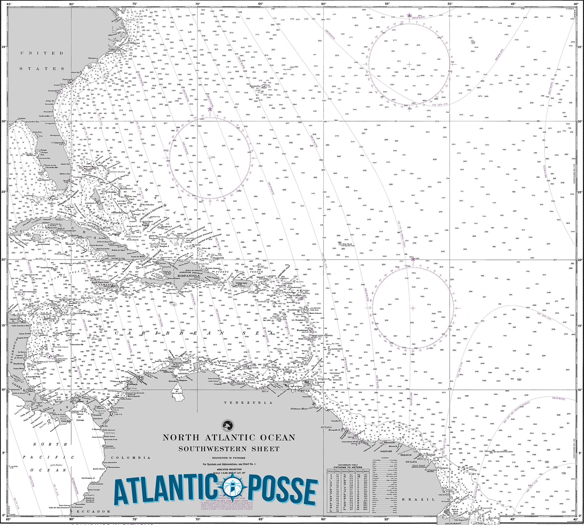
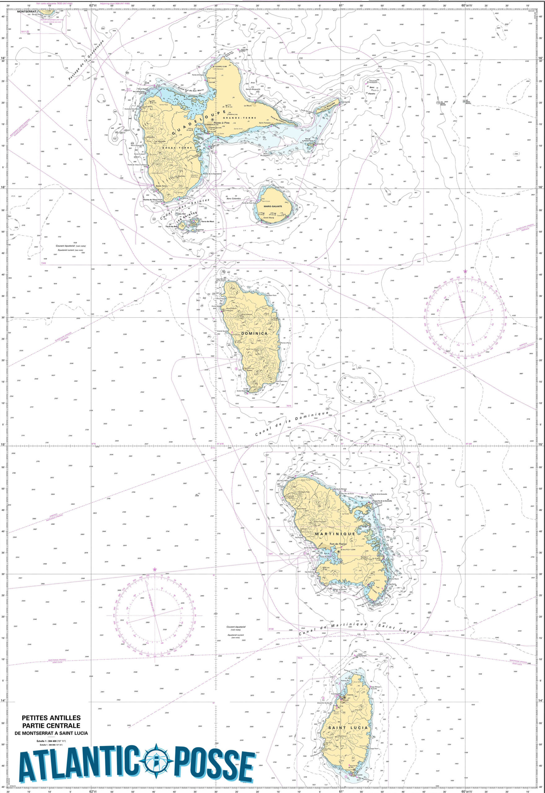
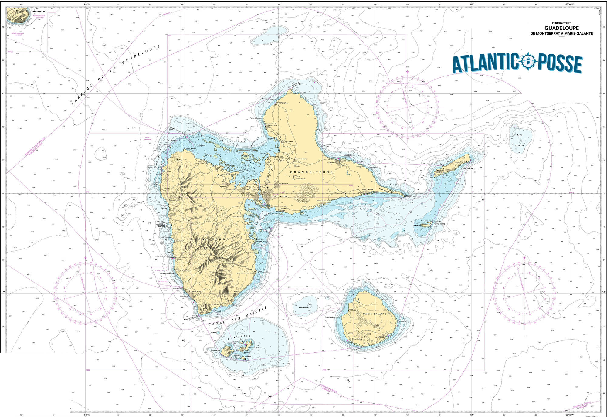
MUST SEE
1. La Soufrière Volcano
- Location: 16°02’18.0″N 61°39’09.6″W
- Description: La Soufrière, also known as “La Grande Dame,” is an active stratovolcano located on Basse-Terre Island and stands as the highest peak in the Lesser Antilles at 1,467 meters (4,813 feet). A hike to the summit is one of the most thrilling adventures in Guadeloupe. The trail, which begins in the lush rainforest, takes you through diverse landscapes, including hot springs, fumaroles, and rocky terrain. As you ascend, you’ll encounter a variety of flora and fauna, including rare orchids and endemic birds. The summit often shrouded in mist, offers dramatic views of the surrounding islands and the Caribbean Sea when the clouds part. The hike is challenging but rewarding, with the volcano’s fumaroles providing an otherworldly atmosphere. The surrounding Guadeloupe National Park, a UNESCO Biosphere Reserve, is also worth exploring for its rich biodiversity and stunning natural beauty.
- Best Time to Visit: The best time to hike La Soufrière is during the dry season from December to April, when the trails are less slippery, and the weather is cooler and more stable.
2. Pointe des Châteaux
- Location: 16°15’36.0″N 61°10’12.0″W
- Description: Pointe des Châteaux is a dramatic and scenic headland located at the easternmost tip of Grande-Terre. This windswept peninsula offers some of the most breathtaking views in Guadeloupe, with rugged cliffs, powerful waves crashing against the rocks, and panoramic vistas of the Atlantic Ocean. A short but steep hike takes you to the top of the headland, where a large cross stands as a beacon over the island. From this vantage point, you can see the islands of La Désirade, Petite-Terre, and even Marie-Galante on a clear day. The area is also rich in biodiversity, with unique flora and fauna adapted to the harsh coastal conditions. Pointe des Châteaux is not just a place of natural beauty but also of cultural significance, with its name and landscape evoking the castles (châteaux) of France.
- Best Time to Visit: The best time to visit Pointe des Châteaux is during the dry season from December to April, when the weather is clear, and the sea is calm, allowing for the best views.
3. Îles des Saintes (Terre-de-Haut)
- Location: 15°52’40.8″N 61°35’09.6″W
- Description: The Îles des Saintes, particularly Terre-de-Haut, is a small archipelago south of Guadeloupe that offers a picturesque and tranquil escape. Terre-de-Haut is the most visited of the islands, known for its charming Creole architecture, vibrant cultural scene, and stunning natural beauty. The island’s main town is a delightful mix of colorful houses, quaint shops, and cozy cafes. One of the must-see sites is Fort Napoléon, perched on a hill overlooking the Bay of Les Saintes, considered one of the most beautiful bays in the world. The fort, now a museum, offers fascinating insights into the island’s history and spectacular views of the surrounding islands. The beaches, such as Plage de Pompierre, are perfect for swimming and snorkeling, with calm, clear waters teeming with marine life. The relaxed pace and friendly locals make Îles des Saintes a favorite among cruisers and travelers alike.
- Best Time to Visit: The best time to visit Îles des Saintes is from December to April, when the weather is dry, and the sea conditions are ideal for sailing and water activities.
4. Jardin Botanique de Deshaies
- Location: 16°18’10.8″N 61°47’34.8″W
- Description: The Jardin Botanique de Deshaies is a stunning botanical garden located in the village of Deshaies on Basse-Terre Island. Spanning over 7 hectares, this garden is a lush paradise of tropical plants, flowers, and wildlife. Visitors can wander through pathways lined with orchids, hibiscus, bougainvillea, and other exotic flora, all set against the backdrop of the Caribbean Sea. The garden also features a koi pond, cascading waterfalls, and aviaries filled with colorful parrots and flamingos. Originally owned by the French comedian Coluche, the Jardin Botanique is now a major attraction for nature lovers and offers a serene escape from the hustle and bustle of daily life. The garden’s design seamlessly blends with the natural landscape, creating a tranquil environment that is both educational and inspiring. It’s a perfect spot for photography, leisurely strolls, or simply relaxing amidst nature.
- Best Time to Visit: The garden is beautiful year-round, but the dry season (December to April) provides the most comfortable weather for exploring the grounds.
5. Plage de Grande Anse
- Location: 16°18’32.4″N 61°47’16.8″W
- Description: Plage de Grande Anse is one of the most stunning beaches in Guadeloupe, located near the village of Deshaies on Basse-Terre Island. This long stretch of golden sand, fringed by swaying palm trees and backed by verdant hills, offers an idyllic setting for relaxation and recreation. The beach is ideal for swimming, sunbathing, and picnicking, with its calm, clear waters and soft, warm sand. Unlike some of the more crowded beaches on Grande-Terre, Plage de Grande Anse remains relatively tranquil, providing a peaceful escape. The beach is also famous for its breathtaking sunsets, where the sky turns into a palette of vibrant colors as the sun dips below the horizon. Nearby, there are small eateries and bars where you can enjoy local Creole cuisine and refreshments after a day at the beach.
- Best Time to Visit: The best time to visit Plage de Grande Anse is during the dry season (December to April), when the weather is sunny and the sea is calm.
6. Carbet Falls (Les Chutes du Carbet)
- Location: 16°02’13.8″N 61°38’49.2″W
- Description: Carbet Falls, or Les Chutes du Carbet, is a series of three spectacular waterfalls located in the Guadeloupe National Park on Basse-Terre Island. The falls are one of the most visited natural attractions in Guadeloupe, drawing visitors with their sheer beauty and the surrounding lush rainforest. The first fall, which is the tallest, drops from a height of 115 meters (377 feet) and is a breathtaking sight. The second fall, accessible by a well-maintained trail, is the most popular and offers a closer view of the cascading water and the pool below. The third fall, though less visited, provides a more secluded and serene experience. The falls are fed by the Rivière du Grand Carbet, originating from the slopes of La Soufrière volcano. The hike to the falls is an adventure in itself, taking you through verdant forests filled with tropical plants, birds, and sometimes, glimpses of wildlife.
- Best Time to Visit: The best time to visit Carbet Falls is during the dry season (December to April), when the trails are less muddy, and the weather is more stable.
These locations highlight the diverse beauty and cultural richness of Guadeloupe, making it a must-visit destination in the Caribbean. Each site offers a unique experience, whether you’re exploring volcanic peaks, relaxing on pristine beaches, or immersing yourself in the island’s vibrant Creole culture.
7. Pointe-à-Pitre
- Location: 16°14’29.4″N 61°32’04.8″W
- Description: Pointe-à-Pitre is the largest city and economic heart of Guadeloupe, located on the island of Grande-Terre. This bustling city is rich in history and culture, offering a blend of French and Creole influences that are evident in its architecture, cuisine, and daily life. The city’s streets are lined with colonial-era buildings, colorful markets, and lively squares. The Place de la Victoire, a central square surrounded by cafes and restaurants, is a great starting point for exploring. The Marché Central is another highlight, where you can immerse yourself in the sights, sounds, and smells of local life, with vendors selling everything from fresh produce and spices to traditional crafts and clothing. Pointe-à-Pitre is also home to the Memorial ACTe, a museum dedicated to the history of slavery, which is a powerful and educational experience. The marina at Bas-du-Fort is a hub for yachts and sailboats, making Pointe-à-Pitre a common stop for cruisers.
- Best Time to Visit: The best time to visit Pointe-à-Pitre is during the dry season (December to April), when the weather is more comfortable for exploring the city.
8. La Désirade
- Location: 16°18’36.0″N 61°04’12.0″W
- Description: La Désirade is a small, serene island located to the east of Grande-Terre. Known for its unspoiled beauty and laid-back atmosphere, La Désirade is a perfect destination for those looking to escape the hustle and bustle of the larger islands. The island is relatively flat compared to the rest of Guadeloupe, with its highest point reaching just 275 meters (902 feet). Its pristine beaches, such as Plage à Fifi and Plage de Baie-Mahault, are some of the best-kept secrets in the Caribbean, offering crystal-clear waters and soft, white sand. The island’s interior is a protected nature reserve, home to unique flora and fauna, including the endangered Lesser Antillean iguana. The main village, Beauséjour, is charming with its small church, friendly locals, and a handful of restaurants serving fresh seafood. La Désirade is also known for its lighthouse and ancient coral reefs, which can be explored through guided tours.
- Best Time to Visit: The best time to visit La Désirade is during the dry season from December to April, when the weather is ideal for beach activities and exploring the island’s natural beauty.
9. Marie-Galante
- Location: 15°55’48.0″N 61°16’12.0″W
- Description: Marie-Galante, often referred to as the “Grande Galette” due to its round shape, is a tranquil island known for its rich history, traditional sugar cane production, and beautiful beaches. Located southeast of Grande-Terre, Marie-Galante offers a slower pace of life and a glimpse into Guadeloupe’s past. The island is dotted with old windmills, remnants of its once-thriving sugar industry, and is famous for producing some of the best rum in the Caribbean. A visit to one of the local distilleries, such as Distillerie Bielle or Distillerie Poisson, is a must to sample the island’s renowned agricole rum. The island’s beaches, particularly Plage de la Feuillère and Plage de l’Anse Canot, are pristine and less crowded than those on the main islands, making them perfect for relaxation and swimming. The main town, Grand-Bourg, is a charming place to explore, with its colonial architecture, lively market, and the beautiful Church of St. Louis.
- Best Time to Visit: The best time to visit Marie-Galante is during the dry season from December to April, when the weather is pleasant and the seas are calm.
10. Réserve Cousteau (Cousteau Reserve)
- Location: 16°09’36.0″N 61°46’26.4″W
- Description: The Cousteau Reserve, located off the coast of Basse-Terre, is one of the top diving and snorkeling spots in the Caribbean. Named after the famous French oceanographer Jacques Cousteau, who declared it one of the best dive sites in the world, this marine reserve is part of the Guadeloupe National Park and is a protected area rich in biodiversity. The reserve encompasses the waters around Pigeon Island, where divers and snorkelers can explore vibrant coral reefs, underwater caves, and an abundance of marine life, including sea turtles, barracudas, and colorful tropical fish. The waters are clear with excellent visibility, making it a paradise for underwater photography. There are also glass-bottom boat tours available for those who prefer to stay dry while enjoying the underwater world. The nearby town of Bouillante offers diving schools and guided tours for both beginners and experienced divers.
- Best Time to Visit: The best time to visit the Cousteau Reserve is from December to April, when the sea conditions are calm, and visibility is at its best.
11. Les Chutes du Carbet (Carbet Falls)
- Location: 16°02’13.8″N 61°38’49.2″W
- Description: Les Chutes du Carbet, or Carbet Falls, is a stunning trio of waterfalls located in the Guadeloupe National Park on Basse-Terre Island. These falls are among the most impressive natural attractions in Guadeloupe, drawing visitors with their dramatic beauty and lush rainforest setting. The first fall, which is the highest at 115 meters (377 feet), is visible from afar and is particularly striking after heavy rains. The second fall, at 110 meters (361 feet), is the most accessible and popular with visitors, offering a spectacular view and a refreshing natural pool at its base. The third fall is smaller but equally beautiful, providing a more secluded and serene experience. The hike to the falls is an adventure through dense rainforest, with the chance to see tropical plants, birds, and other wildlife along the way. The trail is well-maintained, but can be slippery, so good hiking shoes are recommended.
- Best Time to Visit: The best time to visit Carbet Falls is during the dry season (December to April), when the trails are less muddy, and the weather is more favorable for hiking.
12. Plage de Sainte-Anne
- Location: 16°13’48.0″N 61°23’20.4″W
- Description: Plage de Sainte-Anne, located on the southern coast of Grande-Terre, is one of the most popular and picturesque beaches in Guadeloupe. Known for its crystal-clear turquoise waters, soft white sand, and swaying palm trees, this beach offers a quintessential Caribbean experience. It is a family-friendly beach with calm, shallow waters that are perfect for swimming, making it an ideal spot for children and less confident swimmers. The beach is also a great place to try out water sports such as paddleboarding, windsurfing, and kayaking. Along the beachfront, you’ll find a variety of restaurants and beach bars serving local Creole cuisine, fresh seafood, and tropical drinks. The lively market in Sainte-Anne town is also worth a visit, where you can purchase local crafts, spices, and souvenirs. The beach is particularly beautiful at sunrise and sunset, when the sky is painted in shades of orange and pink.
- Best Time to Visit: The best time to visit Plage de Sainte-Anne is during the dry season (December to April), when the weather is warm and sunny, and the sea is calm.
13. La Route de la Traversée
- Location: 16°10’22.8″N 61°40’22.8″W
- Description: La Route de la Traversée, also known as the D23, is a scenic route that cuts through the heart of Basse-Terre Island, offering some of the most breathtaking views in Guadeloupe. This winding road stretches for about 17 kilometers (10.5 miles) through the Guadeloupe National Park, taking you from the east coast to the west coast of the island. Along the way, you’ll pass through dense rainforests, cross rivers, and catch glimpses of towering mountains, including the imposing La Soufrière volcano. There are several lookout points and picnic areas where you can stop to admire the scenery and take photos. Notable stops along the route include the Cascade aux Écrevisses, a small waterfall with a natural pool that’s perfect for a refreshing dip, and the Maison de la Forêt, a visitor center with exhibits about the park’s flora and fauna. La Route de la Traversée is a must-do for nature lovers and photographers, offering a peaceful escape into the heart of Guadeloupe’s natural beauty.
- Best Time to Visit: The best time to drive La Route de la Traversée is during the dry season (December to April), when the road conditions are optimal and the views are clear.
SERVICES & REPAIRS
1. Boat Repair and Maintenance Services
- Location: Various locations including Pointe-à-Pitre and Basse-Terre
- Description: Guadeloupe has several boatyards and repair facilities that offer comprehensive services for maintenance and repairs. These services include hull cleaning and painting, engine repairs, electrical and plumbing work, fiberglass repairs, and rigging services. Some of the well-known facilities include:
- Technimarine: Located near Marina Bas-du-Fort in Pointe-à-Pitre, Technimarine is a large boatyard offering a wide range of repair and maintenance services, including haul-out facilities with travel lifts and crane services.
- Caraïbes Marine Services: Located in Jarry, near Pointe-à-Pitre, this facility specializes in engine repair, electronics, and general maintenance services for yachts and smaller vessels.
2. Chandlery and Marine Supplies
- Location: Pointe-à-Pitre, Basse-Terre, and Saint-François
- Description: Several chandlery stores in Guadeloupe provide a wide range of marine supplies, from spare parts and safety equipment to ropes, sails, and hardware. These stores cater to the needs of both local and visiting boaters. Some key locations include:
- Uship Guadeloupe: Located in Jarry, near Pointe-à-Pitre, Uship is a well-known marine supply store offering a variety of boating essentials, including navigation equipment, safety gear, and maintenance products.
- Caraïbes Ship Chandler: Situated in the Bas-du-Fort area, this store provides a broad selection of marine equipment and supplies, including tools, paints, and cleaning products.
3. Provisioning Services
- Location: Pointe-à-Pitre, Basse-Terre, Saint-François, and other major towns
- Description: Provisioning in Guadeloupe is convenient and diverse, thanks to the island’s mix of French and Creole cultures. Supermarkets and markets are available in major towns, offering a variety of fresh produce, meats, cheeses, wines, and other gourmet products. Some notable places for provisioning include:
- Carrefour Market: Located in Pointe-à-Pitre and other towns, Carrefour offers a wide range of groceries, including fresh fruits, vegetables, meats, and imported goods from France.
- Leader Price and Super U: These supermarkets are also popular for provisioning, offering a variety of food items, beverages, and household goods.
- Local Markets: Visiting local markets, such as the Marché Central in Pointe-à-Pitre or the market in Sainte-Anne, provides an opportunity to buy fresh local produce, spices, and seafood directly from vendors.
4. Fuel Services
- Location: Pointe-à-Pitre, Basse-Terre, Saint-François, and Deshaies
- Description: Fuel services are available at several locations across Guadeloupe, catering to yachts, sailboats, and other vessels. These fuel docks offer diesel, gasoline, and sometimes lubricants and other essentials. Key locations include:
- Fuel Dock at Marina Bas-du-Fort: Pointe-à-Pitre’s marina has a well-equipped fuel dock that services a large number of visiting yachts.
- Fuel Dock at Rivière-Sens: This location in Basse-Terre provides fuel services for boats mooring in the area.
- Saint-François Marina: Offers fuel services for vessels on the eastern side of Grande-Terre.
5. Waste Disposal and Pump-Out Services
- Location: Major marinas and ports, including Pointe-à-Pitre, Basse-Terre, and Deshaies
- Description: Proper waste disposal is crucial for preserving the natural beauty of Guadeloupe’s waters. Waste disposal facilities are available at major marinas, where boaters can dispose of trash, recyclables, and hazardous waste in designated areas. Pump-out services for holding tanks are also available at some locations to manage sewage and bilge water.
- Marina Bas-du-Fort: Offers waste disposal and recycling services, including facilities for hazardous materials like oil and batteries.
- Deshaies Port: Provides basic waste disposal services and encourages responsible waste management among visiting yachts.
6. Diving Services and Equipment Rentals
- Location: Throughout Guadeloupe, particularly in Bouillante, Deshaies, and Saint-François
- Description: Guadeloupe is known for its excellent diving opportunities, especially around the Cousteau Reserve. Numerous dive shops and centers across the islands offer diving services, including equipment rentals, guided dives, and dive certification courses. Some of the well-regarded dive centers include:
- Les Heures Saines: Located in Bouillante near the Cousteau Reserve, this dive center offers a range of services, including guided dives, snorkeling trips, and equipment rentals.
- La Dive Bouteille: Based in Deshaies, this dive shop provides dive trips to various sites around Basse-Terre, as well as equipment rentals and training.
7. Rigging Services
- Location: Pointe-à-Pitre and Basse-Terre
- Description: For sailors needing rigging repairs or adjustments, several service providers specialize in rigging, including tuning, repairs, and replacements. These services are crucial for maintaining the safety and performance of sailing vessels.
- Caraïbes Gréement: Located in Jarry, near Pointe-à-Pitre, this company specializes in rigging services, including inspections, repairs, and installations.
8. Customs and Immigration Clearance Services
- Location: Ports of entry including Pointe-à-Pitre, Basse-Terre, and Deshaies
- Description: While primarily located at marinas and ports, customs and immigration services are essential for cruisers arriving in Guadeloupe. These offices facilitate the clearance process for entering and exiting the territory, ensuring compliance with local regulations. The main offices are situated in:
- Marina Bas-du-Fort, Pointe-à-Pitre: The primary location for clearing customs and immigration in Guadeloupe.
- Port de Plaisance de Rivière-Sens, Basse-Terre: Another key port of entry offering clearance services for vessels.
EMERGENCIES AND SAR INFO
MRCC Fort De France (CROSSAG) (Cospas-Sarsat SPOC)
Type: MRCC, Country: Martinique, SRR: Martinique SRR
Latitude, Longitude:
(14.60000038,-61.08332825)
Telephone:
+596 596 709292 +596 596 731616
Email:
Fax:
+596 596 632450
Website:
https://www.dm.martinique.developpement-durable.gouv.fr/surveillance-et-sauvetage-r12.html
INMARSAT:
Inmarsat C 422 799 024 – Inmarsat C 422 799 244
Telex:
Notes:
ANM 52/12
Emergency Contacts
Quick links: Description Reviews
Ambulance
Contact – Tel: +590 (0) 590 897715
(or only 15 from French phone)
Fire Brigade
Contact – Tel: +590 (0) 590 897718
(or only 18 from French phone)
Police
Contact – Tel: +590 (0) 590 897717
(or only 17 from French phone)

SABA 🇳🇱 CRUISING THE CARIBBEAN WITH THE OCEAN POSSE
SABA 🇳🇱
 Tucked away in the northeastern Caribbean, Saba Island is one of the most remarkable yet lesser-known destinations in this region. As a captain, steering towards this volcanic peak rising from the ocean is an experience that evokes both anticipation and admiration. Saba, often referred to as the “Unspoiled Queen,” is part of the Netherlands Antilles and offers a pristine and authentic Caribbean experience that’s becoming increasingly rare in the region.
Approaching Saba: A Test of Skill
Navigating to Saba requires precision and respect for the island’s unique topography and weather patterns. The island, with its steep cliffs and lack of natural harbors, is not for the faint-hearted or the inexperienced mariner. Approaching from the southeast, you’ll be greeted by the towering Mount Scenery, a dormant volcano that is the highest point in the Netherlands. The island’s coastline is rugged, with waves crashing against sharp rocks and the occasional black sand beach peeking through the cliffs.
Given its small size—just five square miles—Saba is surrounded by deep waters. This means that the approach to Saba requires careful attention to charts, weather conditions, and tidal movements. The island lacks extensive coral reefs or sandbanks that many Caribbean sailors might be used to, which simplifies navigation but requires a cautious approach due to the steep underwater drop-offs close to shore.
Mooring at Saba
The island’s only official point of entry for vessels is Fort Bay, located on the southwestern coast. Fort Bay is a small and practical harbor, home to a few commercial docks and a handful of mooring buoys maintained by the local government. Because of the island’s rugged coastline, anchoring is not allowed, and visitors must use one of these buoys. It’s advisable to contact the harbor in advance to ensure availability, especially during peak season.
Mooring here is a skillful task, given the potential for strong currents and winds funneled between the cliffs. The bay is protected, but not immune to the surge from the open sea, making it imperative to check the weather forecast before arrival. Once securely moored, the first breath you take is a combination of relief and awe—the beauty of Saba lies in its untouched wilderness and the sense of remoteness that permeates the air.
Onshore Experience: A Journey Back in Time
Stepping ashore in Saba feels like entering a different era. The island’s four quaint villages—The Bottom, Windwardside, St. Johns, and Zion’s Hill—are connected by narrow, winding roads that cling to the steep slopes. These roads were constructed by hand by the island’s residents, a testament to their resilience and dedication. For captains and their crews, the exploration of these villages is a must.
The Bottom, the island’s capital, is the most accessible from Fort Bay. It’s a small, picturesque town with red-roofed houses, lush gardens, and friendly locals who greet visitors with a warmth that’s becoming rare in more commercialized parts of the Caribbean. Despite its name, The Bottom sits at an elevation of about 800 feet above sea level, offering panoramic views of the surrounding ocean.
Windwardside, located further up the slopes, is another highlight. This village is the heart of Saba’s tourism, where you’ll find small hotels, charming guesthouses, and a handful of restaurants offering local cuisine. The Saba lacework, a traditional craft passed down through generations, is a unique souvenir that visitors can take home as a reminder of this tranquil island.
Hiking and Exploration: The Crown Jewel of Saba
For those who enjoy the great outdoors, Saba is a paradise. The island’s rugged terrain offers some of the best hiking in the Caribbean. The crown jewel of Saba’s hiking trails is the climb to the summit of Mount Scenery. At 2,910 feet, it’s the highest point in the Dutch Kingdom, and the trail to the top is a challenge that rewards you with breathtaking views. The trail is well-marked but steep, with 1,064 steps leading through dense rainforest to the summit. On a clear day, you can see the neighboring islands of St. Eustatius, St. Kitts, and even St. Barths.
For captains and crew members looking to stretch their legs after days at sea, this hike is a perfect way to immerse yourself in Saba’s natural beauty. The island’s flora and fauna are remarkable, with over 200 species of plants and a rich diversity of birdlife. The trail to Mount Scenery is often shrouded in mist, adding a mystical quality to the journey.
Diving in Saba: A Subaqueous Adventure
Beyond the surface, Saba is renowned for its exceptional diving opportunities. The Saba Marine Park, established in 1987, surrounds the island and offers some of the most pristine dive sites in the Caribbean. The island’s volcanic origins have created a unique underwater landscape of pinnacles, coral gardens, and steep drop-offs.
One of the most famous dive sites is the Pinnacles, a series of underwater mountains that rise dramatically from the ocean floor. These pinnacles are teeming with marine life, from colorful coral formations to large schools of tropical fish, sharks, and rays. For experienced divers, the thrill of exploring these deep-water sites is unparalleled.
As a captain, facilitating a diving excursion for your crew or guests is an opportunity to showcase the hidden wonders of Saba. Local dive shops, such as Sea Saba and Saba Divers, offer guided dives and equipment rentals. It’s important to coordinate with these operators in advance, as diving in Saba requires adherence to strict environmental guidelines to protect the fragile marine ecosystem.
The Allure of Isolation
One of the most striking aspects of Saba is its sense of isolation. Unlike other Caribbean islands, where tourism is a dominant force, Saba has remained largely untouched by mass tourism. There are no large resorts, no bustling beaches, and no shopping malls. Instead, you’ll find an island that moves at its own pace, where the natural environment and the local culture are deeply intertwined.
For captains and sailors, this sense of isolation is both a challenge and a reward. Saba is a place where you can disconnect from the outside world, where the only sounds are the wind in the trees and the waves against the rocks. It’s a place that invites introspection and a deeper connection with the sea.
Practical Considerations for Visiting Captains
While Saba’s charm lies in its remoteness, this also means that certain practical considerations must be taken into account. Provisioning on the island is limited, so it’s essential to stock up on supplies before arrival. Fuel is available at Fort Bay, but it’s recommended to refuel at a larger port before heading to Saba.
Communication can also be a challenge. While the island has decent cellular coverage, internet access can be slow and unreliable. For captains who rely on digital navigation tools and weather updates, it’s wise to download necessary data before approaching the island.
Lastly, it’s important to respect the local regulations, particularly those related to environmental protection. Saba’s government and residents are committed to preserving the island’s natural beauty, and visiting sailors are expected to do their part. This includes proper waste disposal, adherence to mooring guidelines, and respecting the marine park’s no-anchor zones.
Departure: Leaving the Unspoiled Queen
Departing from Saba is a bittersweet experience. As you release the mooring and navigate away from the island’s dramatic coastline, there’s a sense of having discovered a place that few others have. Saba’s rugged beauty, its welcoming communities, and its unspoiled nature leave a lasting impression on those who venture to its shores.
For a captain, Saba is more than just a stopover; it’s a destination that challenges your skills, enriches your journey, and reminds you of the simple, untamed beauty that the Caribbean can still offer. As the island fades into the horizon, there’s a quiet understanding that Saba will remain one of those rare places—a true gem of the sea, cherished by those who have had the privilege to experience it.
In the end, Saba is a testament to the enduring allure of the sea and the islands that rise from it. It’s a place where the spirit of exploration lives on, where the call of the ocean meets the whispers of the wind, and where a captain can find not just a destination, but a profound connection to the world and its wonders.
MARINAS
Saba is a unique destination in the Caribbean due to its rugged terrain and lack of natural harbors, which limits the availability of traditional marinas. The island has only one official point of entry and limited facilities for yachts and boats:
1. Fort Bay Harbor
- Location: 17°37’36.0″N 63°14’13.0″W
- Description: Fort Bay Harbor is the only port and official entry point for vessels on Saba. It is located on the southwestern side of the island. The harbor primarily serves commercial and government vessels but provides limited services for visiting yachts. The harbor is small and can accommodate only a few vessels at a time. Mooring buoys are available in the harbor for visiting boats, as anchoring is not allowed due to the steep underwater drop-offs and to protect the marine environment.
- Facilities: The facilities are minimal, with basic services available, including fuel, water, and customs/immigration clearance. There is a small pier for loading and unloading supplies. However, there are no extensive marina facilities such as repair services or chandlery.
- Contact Information: It’s recommended to contact the harbor authorities in advance to arrange for mooring and entry procedures. Saba’s Marine Park Office also assists with mooring information and regulations.
Key Considerations:
- Mooring: Due to the limited space and facilities, it’s essential to secure a mooring buoy ahead of time, especially during peak seasons. Anchoring is prohibited around the island to protect the coral reefs and marine environment.
- Provisioning: Saba has limited resources, so it’s advisable to provision before arrival. There are a few small grocery stores on the island, but options are limited.
- Fuel: Available at Fort Bay Harbor, but supply can be limited, so plan accordingly.
- Customs and Immigration: All vessels must check in at Fort Bay Harbor, where customs and immigration procedures can be completed.
WEATHER
MAIN LOCAL WEATHER WEBSITE SABA 🇳🇱
SEVERE WEATHER SABA 🇳🇱
PILOT CHARTS
PORTS OF ENTRY
Saba is a unique destination in the Caribbean due to its rugged terrain and lack of natural harbors, which limits the availability of traditional marinas. The island has only one official point of entry and limited facilities for yachts and boats:
1. Fort Bay Harbor
- Location: 17°37’36.0″N 63°14’13.0″W
- Description: Fort Bay Harbor is the only port and official entry point for vessels on Saba. It is located on the southwestern side of the island. The harbor primarily serves commercial and government vessels but provides limited services for visiting yachts. The harbor is small and can accommodate only a few vessels at a time. Mooring buoys are available in the harbor for visiting boats, as anchoring is not allowed due to the steep underwater drop-offs and to protect the marine environment.
- Facilities: The facilities are minimal, with basic services available, including fuel, water, and customs/immigration clearance. There is a small pier for loading and unloading supplies. However, there are no extensive marina facilities such as repair services or chandlery.
- Contact Information: It’s recommended to contact the harbor authorities in advance to arrange for mooring and entry procedures. Saba’s Marine Park Office also assists with mooring information and regulations.
Key Considerations:
- Mooring: Due to the limited space and facilities, it’s essential to secure a mooring buoy ahead of time, especially during peak seasons. Anchoring is prohibited around the island to protect the coral reefs and marine environment.
- Provisioning: Saba has limited resources, so it’s advisable to provision before arrival. There are a few small grocery stores on the island, but options are limited.
- Fuel: Available at Fort Bay Harbor, but supply can be limited, so plan accordingly.
- Customs and Immigration: All vessels must check in at Fort Bay Harbor, where customs and immigration procedures can be completed.
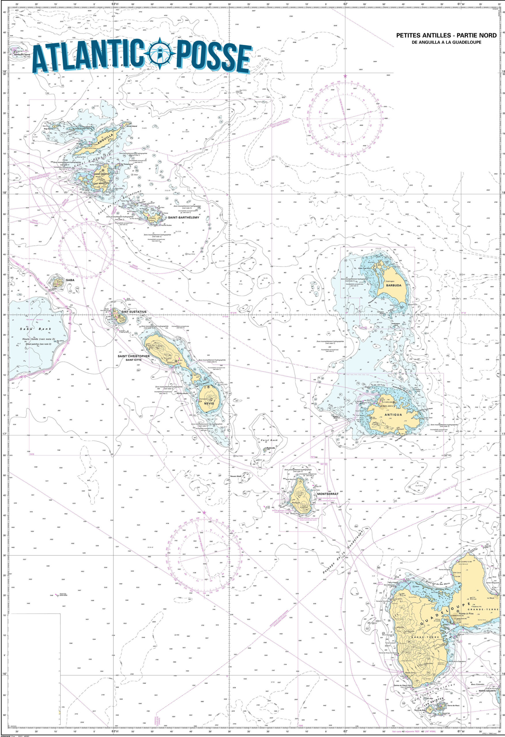
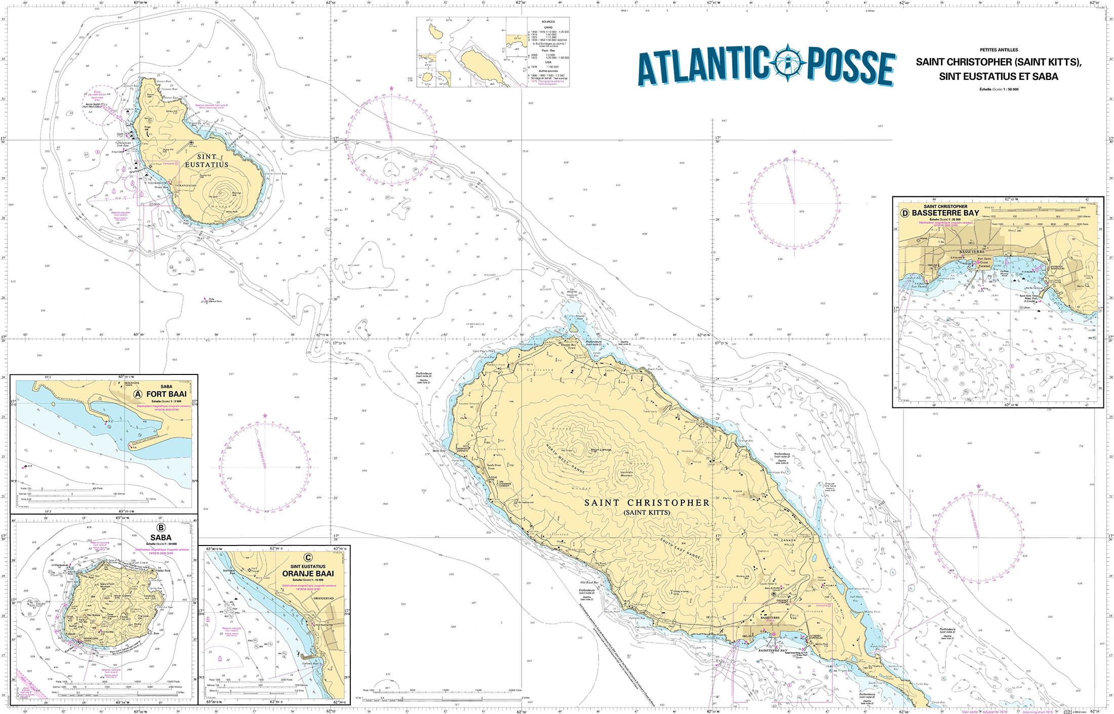
MUST SEE
1. Mount Scenery
- Location: 17°37’31.2″N 63°14’50.4″W
- Description: Mount Scenery, standing at 2,910 feet, is the highest point in the Netherlands and the Caribbean. This dormant volcano offers one of the most rewarding hikes in the region. The trail leading to the summit starts in Windwardside and takes you through lush rainforests filled with exotic flora and fauna. As you ascend the 1,064 steps, you’ll be enveloped in a mystical cloud forest. The summit, often shrouded in mist, offers breathtaking views on clear days, with sights extending to neighboring islands like St. Eustatius and St. Kitts. This hike is a must for any nature lover or adventurer visiting Saba.
- Best Time to Visit: The best time to hike Mount Scenery is during the dry season, from December to April, when the trail is less slippery, and the weather is cooler.
2. Saba Marine Park
- Location: 17°37’24.0″N 63°14’06.0″W
- Description: Established in 1987, the Saba Marine Park surrounds the entire island and is a sanctuary for marine life. The park is renowned for its pristine dive sites, including the famous Pinnacles, underwater mountains that rise from the deep ocean floor. The park’s clear waters, healthy coral reefs, and abundant marine species make it a diver’s paradise. Whether you’re diving or snorkeling, you’ll encounter vibrant coral gardens, tropical fish, sea turtles, and even sharks. The park is meticulously maintained, with strict regulations to preserve its beauty for future generations.
- Best Time to Visit: The best time to visit Saba Marine Park is from December to May, when sea conditions are calm, and visibility is at its best.
3. The Bottom
- Location: 17°37’45.6″N 63°14’49.2″W
- Description: The Bottom is the quaint capital of Saba, nestled in a valley surrounded by steep hills. This village is the administrative heart of the island and home to Saba University School of Medicine. Its charming red-roofed houses, manicured gardens, and friendly locals give The Bottom a warm, welcoming atmosphere. Key sites include the historic Dutch Reformed Church, built in 1919, and the Saba Archaeological Center, which offers insights into the island’s rich history. The Bottom is a perfect place to start your exploration of Saba and to experience the island’s unique culture and community.
- Best Time to Visit: The Bottom can be visited year-round, but the dry season from December to April offers more comfortable weather for exploring the village.
4. Windwardside
- Location: 17°37’54.0″N 63°13’59.4″W
- Description: Windwardside is one of the most picturesque villages on Saba, perched high on the slopes of Mount Scenery. This vibrant village is the heart of Saba’s tourism, with charming guesthouses, restaurants, and shops selling local crafts such as Saba lace. Windwardside offers stunning views of the surrounding hills and ocean, and it’s the starting point for many of the island’s hiking trails. Notable sites include the Saba Museum, which showcases the island’s cultural heritage, and the trailhead for the Mount Scenery hike. Windwardside is the perfect base for exploring the natural and cultural treasures of Saba.
- Best Time to Visit: Visit Windwardside from December to April, when the weather is cooler, and the skies are clear, offering the best views.
5. Tide Pools at Flat Point
- Location: 17°38’06.0″N 63°14’10.8″W
- Description: The Tide Pools at Flat Point offer a unique opportunity to explore Saba’s volcanic coastline. These natural pools are formed by the ocean’s waves crashing into the rocky shore, creating isolated pools filled with marine life. Exploring the tide pools is a fascinating experience, especially during low tide when the pools are more accessible. The pools are teeming with small fish, crabs, and other sea creatures, making it a great spot for nature enthusiasts and photographers. The dramatic backdrop of the cliffs and the sound of the ocean create a serene, otherworldly atmosphere.
- Best Time to Visit: The best time to visit the tide pools is during low tide and calm seas, which are most common from December to April.
6. Ladder Bay
- Location: 17°38’15.0″N 63°14’52.8″W
- Description: Ladder Bay is a historic site on Saba’s western coast, where goods and people were once transported to and from the island before Fort Bay Harbor was constructed. The “Ladder” refers to the steep set of stone steps carved into the cliff, leading from the bay to the village above. Although the climb is challenging, the views from the top are spectacular. The bay itself is a popular spot for snorkeling and diving, offering clear waters and an abundance of marine life. Ladder Bay is a place where history and nature converge, providing a glimpse into Saba’s past and its natural beauty.
- Best Time to Visit: The best time to visit Ladder Bay is from December to April, when the seas are calm, making it easier to explore the bay’s underwater treasures.
7. Troy Hill
- Location: 17°38’30.0″N 63°13’54.0″W
- Description: Troy Hill is a lesser-known but equally captivating spot on Saba. Located near the village of Hell’s Gate, this hill offers panoramic views of the island’s northern coastline and the neighboring island of St. Eustatius. The hike to Troy Hill is moderate, taking you through Saba’s lush, unspoiled landscapes. Along the way, you’ll encounter diverse plant life and may spot some of the island’s resident bird species. At the summit, you’re rewarded with a sense of tranquility and awe as you take in the sweeping views of the Caribbean Sea and the surrounding islands.
- Best Time to Visit: The best time to hike Troy Hill is during the dry season, from December to April, when the trail is in its best condition.
SERVICES & REPAIRS
given its small size and rugged terrain, has limited marine services compared to larger Caribbean islands. However, the island does offer essential services for visiting yachts and boats, particularly in and around Fort Bay Harbor, the main point of entry for vessels. Here’s an overview of the marine services available on Saba:
1. Mooring Buoys
- Location: Fort Bay Harbor, 17°37’36.0″N 63°14’13.0″W
- Description: Due to the steep underwater drop-offs around Saba, anchoring is prohibited. Instead, the island provides several mooring buoys in Fort Bay Harbor for visiting yachts. These moorings are well-maintained and suitable for vessels of varying sizes. It’s advisable to contact the harbor in advance to ensure availability, especially during peak season.
2. Fuel and Water
- Location: Fort Bay Harbor
- Description: Fuel is available at Fort Bay Harbor, though the supply can sometimes be limited, so it’s recommended to refuel before arriving in Saba. Water is also available at the harbor, but visitors should be mindful that water is a precious resource on the island, especially during the dry season.
3. Customs and Immigration Services
- Location: Fort Bay Harbor
- Description: All vessels must check in at Fort Bay Harbor, where customs and immigration services are available. The office is located near the dock, and the process is straightforward, with officials typically available during standard business hours. It’s recommended to have all necessary documentation ready, including passports, vessel registration, and crew lists.
4. Marine Park Regulations and Services
- Location: Saba Marine Park Office, Fort Bay Harbor
- Description: The Saba Marine Park office, located near Fort Bay, provides information and services related to the marine environment. This includes issuing permits for diving and providing guidelines on the use of mooring buoys. The park is highly protected, so all activities must comply with regulations designed to preserve the marine ecosystem.
5. Provisions and Supplies
- Location: Various small shops in The Bottom and Windwardside
- Description: Saba has a few small grocery stores in The Bottom and Windwardside where basic provisions can be purchased. However, given the limited supply, it’s advisable to stock up on essentials before arriving on the island. Specialty items and extensive provisions may not be available.
6. Waste Disposal
- Location: Fort Bay Harbor
- Description: Waste disposal services are available at Fort Bay Harbor, but visitors are expected to follow strict guidelines to protect the island’s environment. Recycling and proper waste management are emphasized, and all visitors are encouraged to minimize their environmental impact.
7. Diving Services
- Location: Windwardside
- Description: Saba is renowned for its diving, and there are a few dive shops, such as Sea Saba and Saba Divers, that offer guided dives, equipment rental, and dive certification courses. While these services are not directly marine services, they are essential for visitors interested in exploring Saba’s underwater attractions.
8. Emergency and Rescue Services
- Location: Fort Bay Harbor
- Description: Saba has a basic emergency response system in place, with services coordinated through the harbor and local authorities. While the island does not have extensive marine rescue facilities, it is part of the regional maritime network, which can be called upon in case of emergency.
EMERGENCIES AND SAR INFO
Saba officials listening to a presentation about the search and rescue boat.
SABA–The public entity of Saba announced on Wednesday that it is slated to receive a search and rescue (SAR) boat in the first half of 2025, which will be used to assist people who need help in Saban waters.
The boat, funded by the Dutch Ministry of Infrastructure and Water Management, was highlighted as a local need following research conducted in 2018 and 2019 by Dutch civil servant Marius Sliedrecht.
According to Saba, there will be a budget for the vessel and its maintenance, as well as for professional equipment, annual training for its crew and the establishment of a management organisation. This was based on a plan drafted in 2021 and 2022 by project leader Hans Schreuder.
“The launch of a SAR vessel marks a significant enhancement in the safety for both residents and visitors, fulfilling a long-awaited request from Saba,” Saba said in a press release on Wednesday. “The importance of the vessel cannot be overstated, as in cases of emergencies the reaction time of the Dutch Caribbean Coast Guard may be lengthy and there are currently no formalised SAR operations on Saba, increasing the risk of those in distress while at sea.”
Airport Manager Maegan Hassell said the vessel will ensure Saba fulfils the requirement of the International Civil Aviation Organization (ICAO) that obliges airports close to water to have specialist aquatic rescue services readily available.
The vessel – a Habbeké Fast Rescue Craft 903 – will be a 30-foot boat and, according to the release, will be specifically crafted to handle Caribbean waters, as well as strong winds, high temperature and the salt from the ocean.
It will have the capacity to carry 21 persons in addition to four members of the rescue team. The boat will have two Volvo Penta engines and will be fitted with jets instead of propellers for “safety reasons”, the release said, adding that a similar vessel is currently being used by Curaçao’s civil rescue organisation.
“The boat should take between nine and 12 months to be built, with the goal of being fully operational within the first half of 2025,” according to the press release.
Saba said training in SAR operations will be offered to a crew of four, but the goal is to grow to eight crew members in total. The training will be done in collaboration with volunteer group Royal Dutch Sea Rescue, who will facilitate certified training for Saba and St. Eustatius in their respective local waters.
“Further collaboration between Saba and St. Eustatius will occur through management and sharing technical and maintenance capacity,” according to the release.
Saba Island Governor Jonathan Johnson thanked the Dutch Ministry of Infrastructure and Water Management for funding the initiative, and Schreuder for “involving the stakeholders during the process.”
“We realise the local situation and the need to ensure international requirements are met. Through patience and persistence, we will actualise a necessary resource for our island,” said Johnson.

DOMINICA 🇩🇲 CRUISING THE LESSER ANTILLES WITH THE OCEAN POSSE
 DOMINICA an unspoiled paradise for sailors
Introduction
Dominica, often referred to as the “Nature Island of the Caribbean,” is a paradise for sailors and cruisers looking for a destination that offers both pristine natural beauty and a sense of adventure. Unlike many of the more developed Caribbean islands, Dominica remains largely untouched by mass tourism, making it a haven for those seeking unspoiled landscapes, vibrant marine life, and a warm, welcoming culture. This island, located between Guadeloupe to the north and Martinique to the south, offers a unique cruising experience that combines challenging sailing conditions with the reward of discovering some of the Caribbean’s most breathtaking natural wonders.
Arrival and Formalities
When approaching Dominica by sea, the island’s lush, mountainous terrain is visible from a distance, providing an exciting prelude to what lies ahead. The main ports of entry for yachts are located in Portsmouth in the north and Roseau in the south. Portsmouth, specifically Prince Rupert Bay, is the most popular anchorage for visiting yachts. The bay is well-protected and offers a variety of mooring options managed by local yacht services, making it a preferred starting point for cruisers.
Upon arrival, sailors must clear customs and immigration, which is a relatively straightforward process. The Dominica Marine Center in Roseau and several yacht service providers in Portsmouth can assist with these formalities. It’s important to note that Dominica is part of the Eastern Caribbean Community (OECS), so visitors arriving from other OECS countries will find the process particularly smooth. The island’s authorities are known for being welcoming and helpful, often providing additional information on where to visit and what to do during your stay.
Portsmouth and Prince Rupert Bay
Prince Rupert Bay, located near the town of Portsmouth, is one of the most popular anchorages in Dominica. The bay is large, well-protected, and offers a range of services for visiting yachts, including moorings, water, fuel, and provisions. The surrounding area is rich in history and natural beauty, making it an excellent base for exploring the island.
One of the highlights of cruising in Prince Rupert Bay is the chance to take a guided tour of the Indian River. This slow-moving river winds its way through dense mangrove forests, offering an up-close look at the island’s diverse flora and fauna. The river is also famous for its appearance in the “Pirates of the Caribbean” movies, and the tour guides often share interesting anecdotes about the filming. The tranquility of the river, combined with the lush vegetation and abundant birdlife, makes for a memorable excursion.
Another must-visit site near Portsmouth is Fort Shirley, a restored 18th-century British garrison located within the Cabrits National Park. The fort offers panoramic views of Prince Rupert Bay and the surrounding area, making it a great spot for photography and history enthusiasts. The park itself is a beautiful area to explore, with several hiking trails that lead through tropical forests to secluded beaches.
Portsmouth also serves as a gateway to exploring the northern part of Dominica, including the Syndicate Nature Trail and the nearby Morne Diablotin, the highest peak on the island. This region is known for its rich biodiversity, including the endemic and endangered Imperial Parrot, also known as the Sisserou Parrot, which is Dominica’s national bird. Hiking in this area offers a chance to experience the island’s unspoiled wilderness and breathtaking views.
Roseau and the Southern Coast
Roseau, the capital of Dominica, is another popular destination for cruisers. The anchorage here is more exposed than in Portsmouth, but it offers the convenience of being close to the island’s cultural and administrative heart. Dominica Marine Center, located in Roseau, provides mooring balls and essential services such as fuel, water, and repairs, making it a practical stop for replenishing supplies and exploring the southern part of the island.
Roseau is a vibrant town that reflects Dominica’s rich cultural heritage. The town is characterized by its colorful Creole architecture, bustling markets, and a mix of French, British, and African influences. Cruisers can spend a day exploring the town’s historical sites, such as the Old Market Plaza, which once served as a slave market and is now a hub for local crafts and souvenirs. The nearby Dominica Museum provides an excellent overview of the island’s history, from its indigenous Kalinago roots to its colonial past.
One of the most popular attractions near Roseau is the Trafalgar Falls, a pair of stunning waterfalls located within easy reach of the town. The falls are accessible via a short hike through lush rainforest, and the reward is a breathtaking view of the twin cascades, one hot and one cold. For the more adventurous, it’s possible to climb up to the base of the falls and take a dip in the natural pools below.
Another highlight of cruising the southern coast of Dominica is the chance to visit the Boiling Lake, one of the largest geothermal lakes in the world. This challenging hike takes you through the Valley of Desolation, a surreal landscape of steaming vents and boiling mud pots, before reaching the lake itself. The hike is strenuous but offers some of the most spectacular scenery on the island, making it a must-do for those who enjoy outdoor adventure.
Dominica’s Marine Life and Diving Opportunities
Dominica is renowned for its incredible marine biodiversity, making it a top destination for diving and snorkeling enthusiasts. The island’s underwater landscape is characterized by steep drop-offs, volcanic pinnacles, and vibrant coral reefs, providing a habitat for a wide variety of marine life.
One of the best places to dive in Dominica is Champagne Reef, located just south of Roseau. The reef gets its name from the continuous stream of bubbles rising from the volcanic vents on the sea floor, creating an effect similar to swimming through a glass of champagne. The warm waters and unique underwater features attract a diverse range of marine species, including seahorses, frogfish, and a variety of colorful reef fish. The reef is accessible to both snorkelers and divers, making it a popular spot for visitors of all experience levels.
Another excellent diving location is Scott’s Head Marine Reserve, located at the southern tip of the island. This area is known for its dramatic underwater terrain, with sheer walls and deep canyons that are home to large pelagic species such as barracuda, tuna, and the occasional dolphin. The reserve is also a great place to see turtles, rays, and the island’s famous sperm whales, which can often be spotted in the waters around Dominica.
For those interested in whale watching, Dominica offers some of the best opportunities in the Caribbean. The island is one of the few places in the world where sperm whales can be seen year-round, and there are several local operators offering whale-watching tours. In addition to sperm whales, visitors may also encounter humpback whales, pilot whales, and a variety of dolphin species.
Environmental Consciousness and Sustainable Tourism
Dominica has made a strong commitment to environmental conservation and sustainable tourism, which is evident in its approach to managing both land and marine resources. The island’s national parks and marine reserves are well-protected, and there are strict regulations in place to ensure that tourism activities do not harm the environment.
For cruisers, this means being mindful of anchoring practices and respecting local guidelines for waste disposal and resource use. Many of the island’s mooring facilities are located in sensitive marine environments, so it’s important to use designated mooring balls rather than anchoring on the reef. Additionally, cruisers are encouraged to support local businesses and engage in eco-friendly activities that contribute to the preservation of Dominica’s natural heritage.
The island’s commitment to sustainability extends to its community-based tourism initiatives, which aim to provide economic benefits to local residents while preserving cultural traditions and protecting the environment. By participating in locally guided tours and purchasing goods from local vendors, cruisers can contribute to the island’s sustainable development and help ensure that Dominica remains an unspoiled paradise for future generations.
Practical Tips for Cruising Dominica
When planning a cruising trip to Dominica, there are several practical considerations to keep in mind. The island’s climate is tropical, with a wet season from June to November and a dry season from December to May. The best time to visit is during the dry season when the weather is more stable, and the risk of hurricanes is lower.
It’s also important to note that while Dominica offers stunning natural beauty and a wealth of activities, the island is still developing its infrastructure. Cruisers should be prepared for limited services in some areas and should stock up on essential supplies before arriving. That said, the island’s charm lies in its unspoiled nature and the warm hospitality of its people, making any minor inconveniences well worth the experience.
Safety is another consideration when cruising Dominica. While the island is generally safe, it’s always wise to take standard precautions, such as locking up your boat when ashore and being aware of your surroundings. The local yacht services in Portsmouth and Roseau provide security services, which can give cruisers additional peace of mind.
Finally, cruisers should take advantage of the opportunity to explore Dominica’s vibrant culture and connect with the local community. The island’s festivals, such as Carnival and the World Creole Music Festival, offer a unique insight into the island’s rich cultural heritage and are well worth attending if your visit coincides with these events.
MARINAS
🇩🇲 DOMINICA
1. Portsmouth Marine (Prince Rupert Bay)
- Location: 15°34.758′ N, 61°27.864′ W
- Description: Portsmouth Marine, located in Prince Rupert Bay, is the most popular and well-equipped mooring facility in Dominica. It offers 30 moorings, catering to yachts and sailboats. The facility provides services such as water, fuel, garbage disposal, and Wi-Fi. Portsmouth Marine is known for its friendly staff and proximity to the town of Portsmouth, making it a convenient base for exploring the northern part of the island. Security services are available, ensuring a safe stay for yachts. The area is also popular for tours to the Indian River and nearby national parks.
- Contact Info:
- Phone: +1 767-445-4322
- Email: info@portsmouthmarine.com
- Website: portsmouthmarine.com
2. Roseau Anchorage (Dominica Marine Center)
- Location: 15°17.646′ N, 61°23.034′ W
- Description: Located in the capital city of Roseau, the Roseau Anchorage, managed by Dominica Marine Center, offers mooring balls and limited dock space. The facility provides essential services including water, fuel, Wi-Fi, and a chandlery. The anchorage is ideally situated for those wishing to explore Roseau’s markets, restaurants, and cultural attractions. The Dominica Marine Center also offers boat repair services and can assist with customs and immigration procedures. The anchorage is popular with visiting yachts, providing a good base for exploring Dominica’s southern regions, including the famous Trafalgar Falls and the Boiling Lake.
- Contact Info:
- Phone: +1 767-448-3220
- Email: info@dominicamarinecenter.com
- Website: dominicamarinecenter.com
3. Cobra Tours & Yacht Services (Portsmouth)
- Location: 15°34.536′ N, 61°27.724′ W
- Description: Cobra Tours & Yacht Services is another key facility in Portsmouth, offering yacht services and moorings in Prince Rupert Bay. Known for their personalized service, they offer water, fuel, laundry, provisioning, and guided tours. The facility also arranges customs and immigration clearance for visiting yachts. The close proximity to Portsmouth town provides easy access to shops, restaurants, and other amenities.
- Contact Info:
- Phone: +1 767-445-5296
- Email: cobrayachtservices@gmail.com
- Website: cobra-tours.com
4. Big Papa’s Dock (Portsmouth)
- Location: 15°34.842′ N, 61°27.967′ W
- Description: Big Papa’s Dock is a small docking facility in Portsmouth, offering mooring and docking services for smaller vessels. The dock is adjacent to a popular local restaurant and bar, making it a social hub for visiting sailors. While the facilities are limited, they offer basic services such as water and electricity. The dock is well-suited for short-term stays or those looking for a more informal mooring option.
- Contact Info:
- Phone: +1 767-275-5093
- Email: bigpapasdock@gmail.com
5. Yachting Services of Dominica (YSOD)
- Location: 15°34.754′ N, 61°27.852′ W
- Description: Yachting Services of Dominica, located in Portsmouth, offers comprehensive yacht services including moorings, provisioning, and repairs. They provide assistance with customs and immigration and offer a range of tours and excursions. YSOD is known for their attention to detail and excellent customer service, making them a top choice for sailors visiting Dominica.
- Contact Info:
- Phone: +1 767-225-2000
- Email: info@ysodominica.com
- Website: ysodominica.com
These marinas and yacht services in Dominica cater to the needs of visiting sailors, offering essential facilities and services. Dominica’s marinas are generally smaller and less developed compared to those on other Caribbean islands, but they provide a warm and welcoming environment with access to the island’s stunning natural beauty.
WEATHER
MAIN LOCAL WEATHER WEBSITE /span>
SEVERE WEATHER DOMINICA
PILOT CHARTS
PORTS OF ENTRY
1. Roseau Port
- Latitude/Longitude: 15°17.507′ N 061°23.408′ W
- Description: Roseau is the capital and the main port of entry for Dominica. It is located on the southwestern coast of the island and serves as a central hub for maritime activities. The port is equipped with facilities for customs and immigration, making it a convenient stop for yachts and vessels entering Dominica. The surrounding area offers a mix of modern amenities and traditional Caribbean charm, with easy access to local markets, shops, and restaurants.
2. Portsmouth Port
- Latitude/Longitude: 15°34.520′ N 061°27.739′ W
- Description: Located on the northwestern coast, Portsmouth is another primary port of entry for Dominica. This port is situated near Prince Rupert Bay, a popular anchorage for yachts and cruisers. Portsmouth offers essential services like customs and immigration, and the town itself is known for its laid-back atmosphere and proximity to natural attractions such as the Indian River and Cabrits National Park.
3. Douglas-Charles Airport (Melville Hall)
- Latitude/Longitude: 15°32.712′ N 061°18.271′ W
- Description: While primarily an airport, Douglas-Charles Airport also serves as an entry point for those arriving by private or chartered aircraft. The airport is located on the northeastern coast of Dominica, and customs and immigration services are available for both air and sea arrivals. The surrounding area is more remote, offering a quieter entry point with access to the island’s rugged and pristine eastern coast.
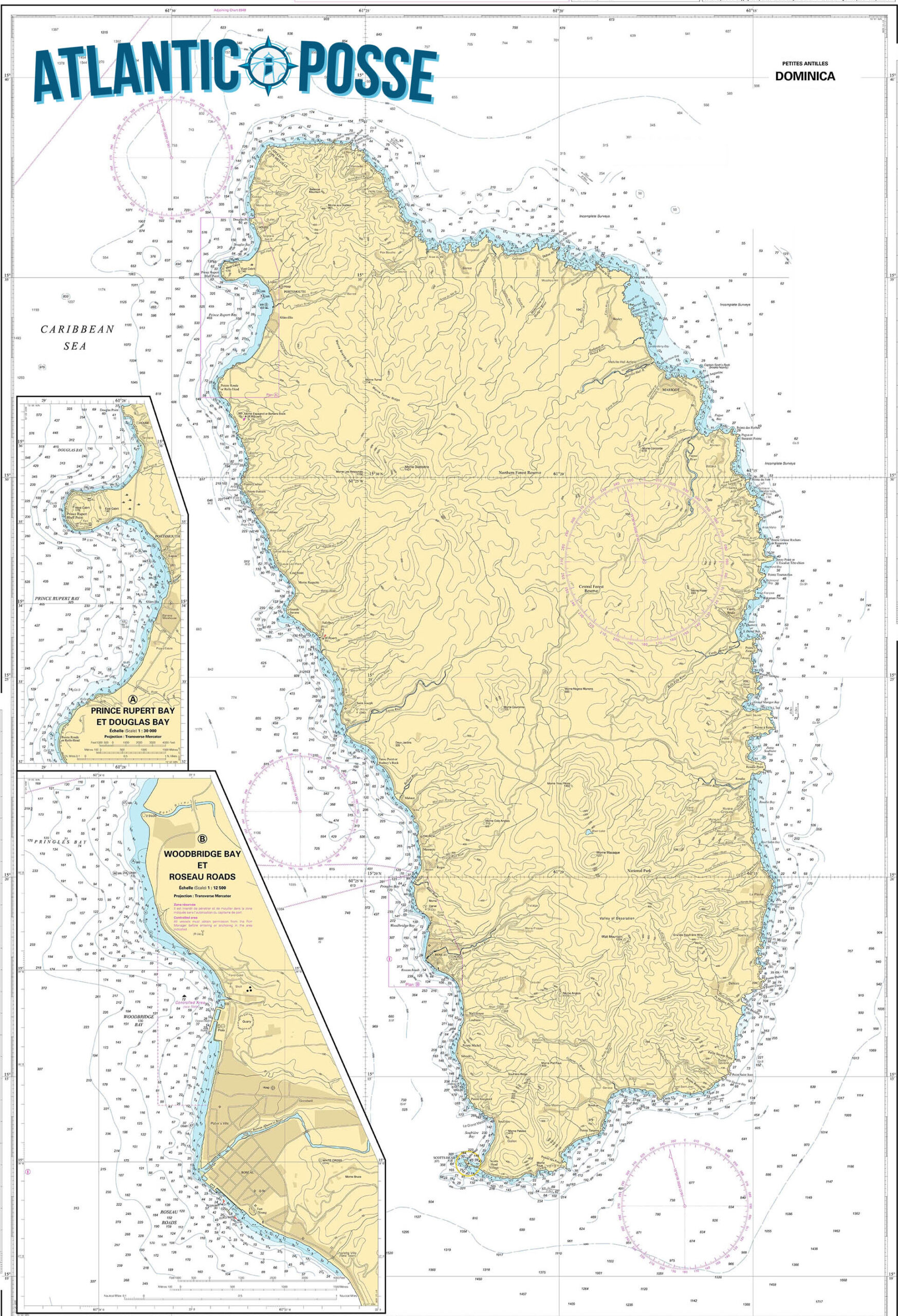
MUST SEE ON DOMINICA
1. Boiling Lake
- Latitude/Longitude: 15°18.457′ N 061°19.654′ W
- Description: Boiling Lake, located in the Morne Trois Pitons National Park, is the second-largest hot spring in the world. The lake, which appears as a bubbling cauldron of greyish-blue water, is heated by a volcanic fumarole beneath it. The hike to Boiling Lake is challenging, taking you through dense rainforests, over steep ridges, and past sulfur springs, but the experience is well worth it. The otherworldly landscape and the sight of the boiling water are unforgettable.
- Best Time to Visit: December to May (Dry season)
2. Trafalgar Falls
- Latitude/Longitude: 15°19.402′ N 061°20.791′ W
- Description: Trafalgar Falls, known as the “Twin Falls,” is a stunning natural attraction located near Roseau. The twin waterfalls, one hot and one cold, cascade side by side through lush vegetation. A short hike from the visitor center takes you to a viewing platform where you can marvel at the falls. Adventurous visitors can scramble over rocks to get closer or even take a dip in the refreshing pools below.
- Best Time to Visit: December to May (Dry season)
3. Champagne Reef
- Latitude/Longitude: 15°14.045′ N 061°22.983′ W
- Description: Champagne Reef is one of Dominica’s premier snorkeling and diving sites, famous for the streams of warm, bubbling water that rise from volcanic vents on the ocean floor, creating the effect of swimming through a glass of champagne. The reef is teeming with colorful marine life, including coral, sponges, and tropical fish, making it a must-visit for underwater enthusiasts.
- Best Time to Visit: December to May (Dry season)
4. Emerald Pool
- Latitude/Longitude: 15°22.356′ N 061°19.870′ W
- Description: The Emerald Pool is a tranquil, hidden gem nestled in the heart of the rainforest within Morne Trois Pitons National Park. This small, crystal-clear pool is fed by a gentle waterfall and is surrounded by lush greenery, giving it a magical, otherworldly feel. A short, easy hike leads you to the pool, where you can take a refreshing dip or simply enjoy the serene environment.
- Best Time to Visit: December to May (Dry season)
5. Sari-Sari Falls
- Latitude/Longitude: 15°19.709′ N 061°15.210′ W
- Description: Sari-Sari Falls is a stunning waterfall located near the village of La Plaine on Dominica’s eastern coast. The hike to the falls is moderately challenging, taking you through the rainforest and across rivers, but the reward is a spectacular view of the powerful waterfall cascading into a deep pool. The area is less crowded than other tourist spots, offering a peaceful, immersive experience.
- Best Time to Visit: December to May (Dry season)
6. Indian River
- Latitude/Longitude: 15°34.149′ N 061°28.199′ W
- Description: The Indian River, located near Portsmouth, offers a unique and serene experience as you glide through mangrove forests on a guided boat tour. The river is known for its lush vegetation, including swamp bloodwood trees with impressive buttress roots, and for being a filming location in the “Pirates of the Caribbean” movies. The tour often includes a stop at the Bush Bar, a rustic riverside establishment.
- Best Time to Visit: December to May (Dry season)
7. Morne Diablotin National Park
- Latitude/Longitude: 15°32.793′ N 061°24.146′ W
- Description: Morne Diablotin National Park is home to the highest peak in Dominica, Morne Diablotin, which stands at 4,747 feet. The park is a haven for nature lovers, offering challenging hikes through dense rainforest and the chance to spot the endangered Sisserou parrot, Dominica’s national bird. The summit hike is demanding but offers breathtaking views of the island and the surrounding Caribbean Sea.
- Best Time to Visit: December to May (Dry season)
8. Carib Territory (Kalinago Barana Aute)
- Latitude/Longitude: 15°27.581′ N 061°17.891′ W
- Description: The Carib Territory, or Kalinago Barana Aute, is home to the indigenous Kalinago people. This area offers a fascinating insight into the island’s pre-colonial history and the culture of the Kalinago. Visitors can explore traditional thatched huts, witness craft demonstrations, and learn about the Kalinago’s way of life, which has been preserved for centuries.
- Best Time to Visit: December to May (Dry season)
9. Scott’s Head
- Latitude/Longitude: 15°13.489′ N 061°22.816′ W
- Description: Scott’s Head, located at the southern tip of Dominica, is a picturesque village and the site where the Atlantic Ocean meets the Caribbean Sea. A short hike up the hill offers panoramic views of the rugged coastline, the village, and the merging waters. The area is also a popular spot for snorkeling and diving, with vibrant marine life and clear waters.
- Best Time to Visit: December to May (Dry season)
10. Wotten Waven Sulphur Springs
- Latitude/Longitude: 15°19.668′ N 061°20.437′ W
- Description: The Wotten Waven Sulphur Springs are located near Roseau in the village of Wotten Waven. This geothermal area is known for its hot mineral springs and therapeutic mud baths. Visitors can relax in the natural hot pools, surrounded by the lush greenery of the rainforest, and enjoy the rejuvenating properties of the sulfur-rich waters.
- Best Time to Visit: December to May (Dry season)
11. Middleham Falls
- Latitude/Longitude: 15°21.415′ N 061°19.862′ W
- Description: Middleham Falls, located within the Morne Trois Pitons National Park, is one of the tallest waterfalls on the island, plunging over 200 feet into a pool below. The hike to the falls takes you through a beautiful rainforest and offers the opportunity to see a variety of flora and fauna. The sight of the powerful waterfall cascading into the misty pool is a highlight for many visitors.
- Best Time to Visit: December to May (Dry season)
12. Victoria Falls
- Latitude/Longitude: 15°18.939′ N 061°16.635′ W
- Description: Victoria Falls, located near the village of Delices, is a spectacular waterfall that is fed by the White River. The hike to the falls is relatively short but requires crossing the river multiple times, adding an adventurous element to the journey. The falls themselves are breathtaking, with water cascading over a steep cliff into a deep pool surrounded by lush vegetation.
- Best Time to Visit: December to May (Dry season)
SERVICES & REPAIRS
1. Dominica Marine Center
- Location: Roseau, Dominica
- Services: Full-service marina offering fuel, water, provisioning, and boatyard services. They provide yacht maintenance, repairs, chandlery, and a wide range of marine supplies. Additionally, they offer a dinghy dock, mooring, and waste disposal services.
- Contact: +1 (767) 448-2705 | info@dominicamarinecenter.com
- Website: Dominica Marine Center
2. Portsmouth Association of Yacht Services (PAYS)
- Location: Portsmouth, Prince Rupert Bay, Dominica
- Services: PAYS is a collective of local boat boys who provide various services to visiting yachts, including secure mooring, water, fuel, provisioning, and guided tours. They also organize a weekly BBQ for sailors.
- Contact: +1 (767) 225-4028 | info@paysdominica.com
- Website: PAYS Dominica
3. Sea Cat Yacht Services
- Location: Roseau, Dominica
- Services: Sea Cat offers a range of yacht services including guided tours, provisioning, waste disposal, and general assistance with customs and immigration. They also provide mooring services in Roseau.
- Contact: +1 (767) 245-9640 | seacatservices@gmail.com
- Website: Sea Cat Dominica
4. Ross University Marine Services
- Location: Portsmouth, Dominica
- Services: Catering primarily to research and educational vessels, Ross University offers docking, fuel, water, and basic marine services for yachts and boats associated with academic activities.
- Contact: +1 (767) 255-6500
- Website: Ross University
5. Cobra Tours & Yacht Services
- Location: Portsmouth, Prince Rupert Bay, Dominica
- Services: Offers mooring, water, fuel, guided tours, and assistance with customs and immigration. Cobra is also known for organizing river tours and cultural experiences for yacht visitors.
- Contact: +1 (767) 445-5007 | cobratours@hotmail.com
- Website: Cobra Tours
6. Big Papa’s Marina
- Location: Portsmouth, Prince Rupert Bay, Dominica
- Services: A small marina offering basic services such as mooring, water, and fuel. Big Papa’s also has a popular beach bar and restaurant, making it a social hub for sailors.
- Contact: +1 (767) 275-3224
7. Anchorage Hotel, Whale Watch & Dive Center
- Location: Castle Comfort, Roseau, Dominica
- Services: While primarily a dive center, they offer mooring and docking services for visiting yachts. The center also provides dive tours, whale watching excursions, and marine fuel.
- Contact: +1 (767) 448-2638 | anchoragehotel@cwdom.dm
- Website: Anchorage Hotel Dominica
8. Dominica Yachting Services
- Location: Roseau, Dominica
- Services: Offers yacht provisioning, chandlery, boat repairs, and other marine services. They also provide assistance with customs and immigration formalities for arriving yachts.
- Contact: +1 (767) 225-8255 | dominicayachtingservices@gmail.com
9. Jolly’s Marine Services
- Location: Roseau, Dominica
- Services: Part of Jolly’s Pharmacies, this branch specializes in marine products, including safety equipment, fishing gear, and boat supplies. They also provide basic yacht services.
- Contact: +1 (767) 448-2871 | info@jollys.dm
- Website: Jolly’s Marine Services
10. North Cabrits Marine Services
- Location: Portsmouth, Dominica
- Services: A small boatyard offering haul-out services, boat repairs, and storage. They also provide mooring and general marine maintenance services.
- Contact: +1 (767) 445-4567
EMERGENCIES AND SAR INFO
DOMINICA SAR IS COVERED BY MARTINIQUE
MRCC Fort De France (CROSSAG) (Cospas-Sarsat SPOC)
Type: MRCC, Country: Martinique, SRR: Martinique SRR
Latitude, Longitude:
(14.60000038,-61.08332825)
Telephone:
+596 596 709292 +596 596 731616
Email:
Fax:
+596 596 632450
Website:
https://www.dm.martinique.developpement-durable.gouv.fr/surveillance-et-sauvetage-r12.html
INMARSAT:
Inmarsat C 422 799 024 – Inmarsat C 422 799 244
Telex:

CAPE VERDE 🇨🇻 CRUISING THE ATLANTIC ISLANDS WITH THE OCEAN POSSE
 Cape Verde, an archipelago of 10 volcanic islands in the central Atlantic Ocean, is a must-visit destination for cruisers seeking a mix of adventure, cultural richness, and stunning natural beauty. Located off the coast of West Africa, it offers a unique blend of African, Portuguese, and Brazilian influences, making it a fascinating stopover for yachts crossing the Atlantic.
Navigational Insights: Approaching Cape Verde from the north or east is relatively straightforward, with the islands offering good visibility. However, the Harmattan winds, blowing from the Sahara, can occasionally reduce visibility and cause dust haze, so it’s wise to stay vigilant. The seas around the islands can be choppy, especially during the winter months when the northeast trade winds are strong. Careful navigation is required around the islands’ numerous reefs and rocky outcrops, especially when approaching ports.
Ports and Anchorages: Cape Verde has several ports and anchorages suitable for yachts. Mindelo on São Vicente is the main port of entry and offers the best facilities, including fuel, water, provisions, and repairs. The marina is well-protected, and the local maritime authorities are generally helpful. Tarrafal on Santiago Island and Sal Rei on Boa Vista are also popular stops, providing safe anchorages and opportunities to explore the islands.
Weather and Timing: The best time to visit Cape Verde is between November and April when the trade winds are consistent, making for smooth sailing conditions. The climate is arid, with temperatures ranging from 22°C to 30°C. The rainy season, which runs from August to October, can bring sudden downpours and rougher seas, but these are generally short-lived.
Cultural and Shore Experiences: Cape Verde’s culture is a vibrant mix of African and Portuguese traditions. The islands are known for their morna music, a melancholic genre that reflects the nation’s history and soul. Cruisers can enjoy the lively markets, local cuisine, and the warm hospitality of the Cape Verdean people. Exploring the islands reveals dramatic landscapes, from the barren, lunar-like terrain of Sal to the lush green valleys of Santo Antão.
Challenges: While Cape Verde is a welcoming destination, cruisers should be aware of potential challenges. Provisioning outside of Mindelo can be limited, so it’s advisable to stock up on essentials. Water can also be scarce, particularly on the drier islands. Security is generally good, but it’s wise to take precautions, especially in more remote anchorages.
Conclusion: Cape Verde is a rewarding destination for cruisers, offering a unique blend of cultures, breathtaking landscapes, and reliable sailing conditions. Whether using it as a stopover on an Atlantic crossing or as a destination in its own right, Cape Verde provides a rich cruising experience that stays with you long after you’ve sailed away.
MARINAS
1. Mindelo Marina, São Vicente
- Location: 16°53.457’N 24°59.210’W
- Description: Mindelo Marina is the largest and most popular marina in Cape Verde, located in the bustling port city of Mindelo on São Vicente Island. The marina offers 120 berths, modern facilities, and is well-protected from prevailing winds. It’s a primary stop for yachts crossing the Atlantic, with services including fuel, water, electricity, Wi-Fi, laundry, and a well-stocked chandlery. The nearby town is vibrant, offering plenty of dining, entertainment, and provisioning options, along with a rich cultural experience.
- Contact: +238 232 10 70 / info@marinamindelo.cv
2. Porto Grande Bay, São Vicente
- Location: 16°53.604’N 24°59.197’W
- Description: While not a dedicated marina, Porto Grande Bay is a natural harbor adjacent to Mindelo Marina, offering excellent anchorage. The bay is deep and spacious, with good holding ground, making it a popular choice for those preferring to anchor. The bay is also home to the Mindelo Yacht Club, which provides some facilities to visiting yachts, including showers and a bar. This location is convenient for accessing Mindelo’s amenities without the need for a formal berth.
- Contact: +238 232 11 21 / yachtclubemindelo@gmail.com
3. Sal Rei Anchorage, Boa Vista
- Location: 16°10.423’N 22°54.964’W
- Description: Sal Rei is the main anchorage on Boa Vista Island, located near the town of the same name. The anchorage is generally calm, protected by surrounding reefs and islets, though care must be taken when navigating through the entrance. The town is smaller and more laid-back compared to Mindelo, but offers basic provisions, a few local restaurants, and the opportunity to explore Boa Vista’s stunning beaches and dunes. There is no marina here, so all services must be managed independently.
- Contact: No marina facilities, local authorities available via VHF Channel 16.
4. Palmeira Harbor, Sal
- Location: 16°45.231’N 22°59.732’W
- Description: Palmeira Harbor on the island of Sal is a well-sheltered anchorage primarily used by fishing boats and visiting yachts. The harbor has no marina, but it offers a secure spot to anchor with easy access to the town of Palmeira, where basic services and provisions can be found. Sal Island is known for its water sports, particularly windsurfing and kiteboarding, and cruisers can explore the island’s stark, beautiful landscape. Fresh water is available at the harbor, but facilities are limited.
- Contact: No formal marina, VHF Channel 16 for local authorities.
5. Porto Tarrafal, Santiago
- Location: 15°16.986’N 23°45.292’W
- Description: Porto Tarrafal is located on the northern coast of Santiago Island and is a well-known anchorage spot for cruisers. The bay offers good protection from the northeast trade winds, with a sandy bottom providing secure anchoring. The small town of Tarrafal is charming, with local markets, eateries, and a relaxed atmosphere. The beach is one of the best in Cape Verde, with clear waters ideal for swimming. There are no marina facilities, so yachts must be self-sufficient.
- Contact: No formal marina, VHF Channel 16 for local authorities.
6. Porto da Praia, Santiago
- Location: 14°54.423’N 23°30.156’W
- Description: Porto da Praia is the main commercial port on Santiago Island, situated in the capital city of Praia. While primarily a commercial and fishing port, there is a designated anchorage area for yachts. The port is busy, so yachts must be vigilant of ship traffic. Praia offers full city amenities, including provisioning, restaurants, and cultural sites. Security can be a concern, so precautions are advised. There are no marina facilities specifically for yachts, but some basic services like fuel and water are available.
- Contact: +238 261 47 12 / porto.praia@enapor.cv
WEATHER CAPE VERDE

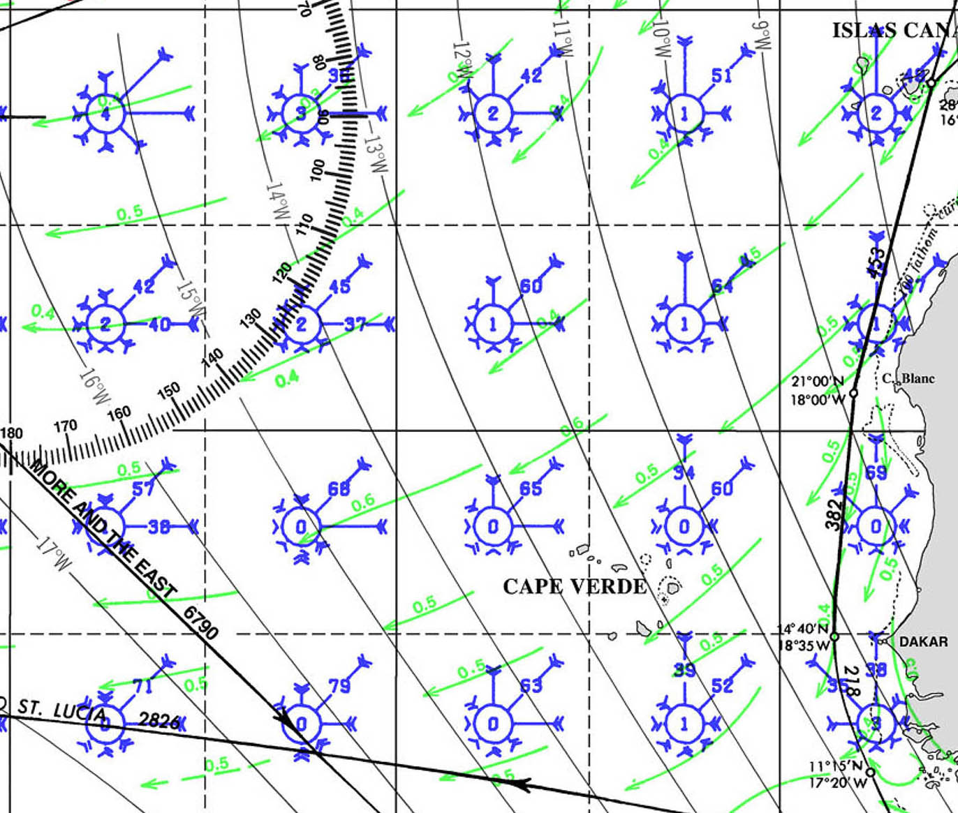
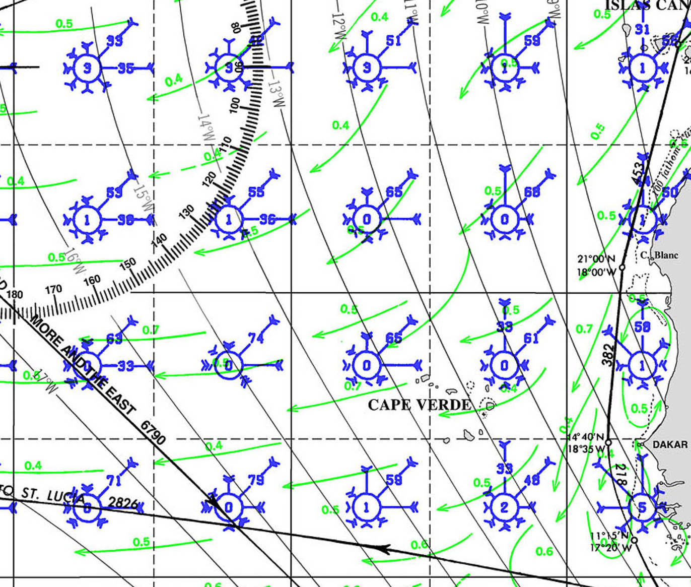
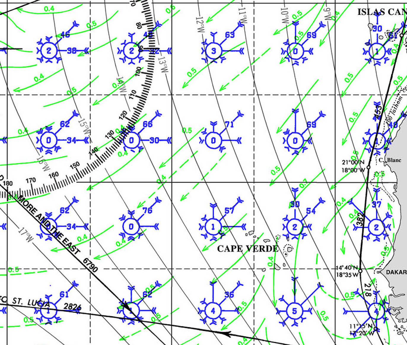
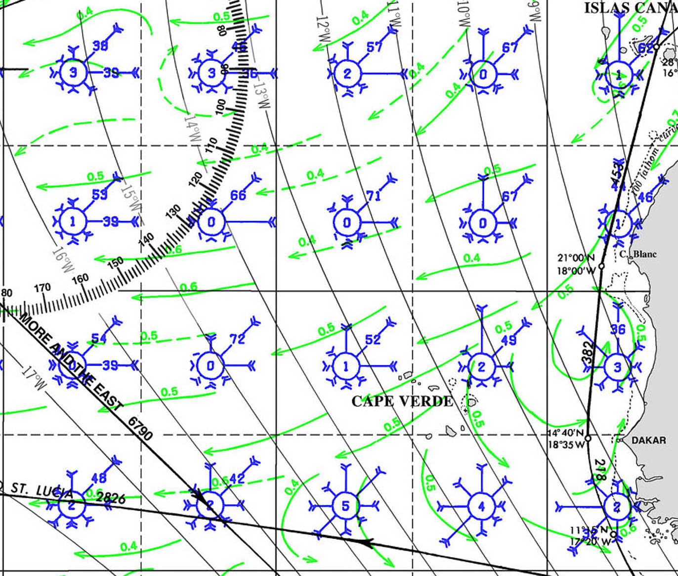
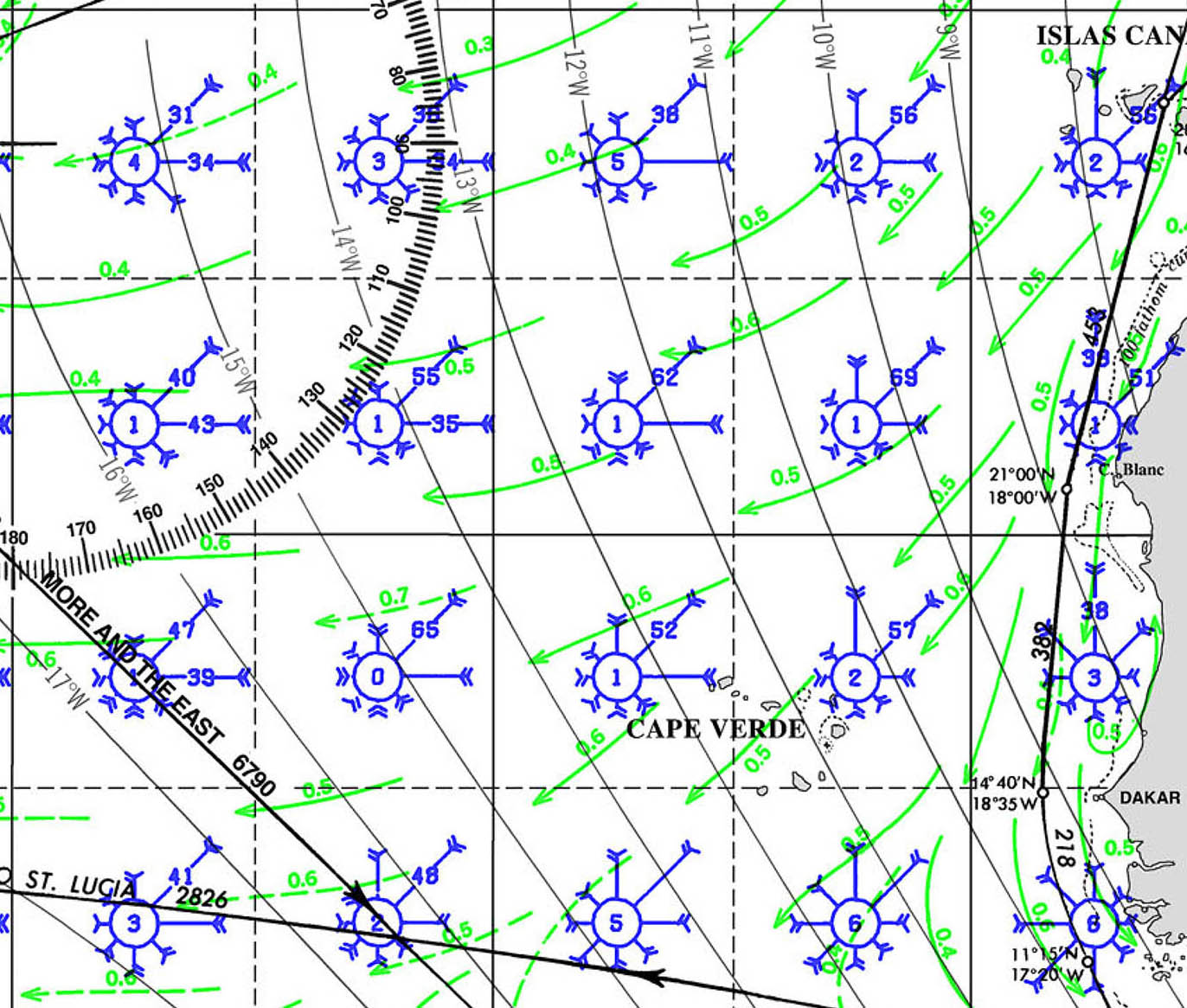

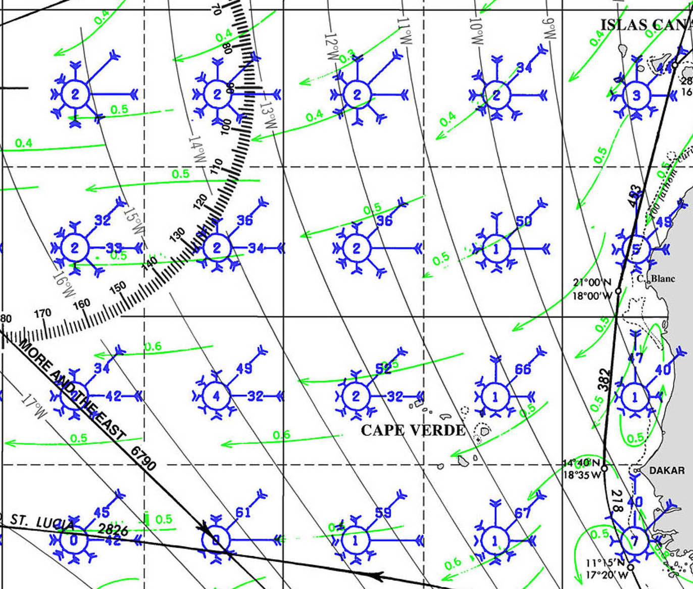
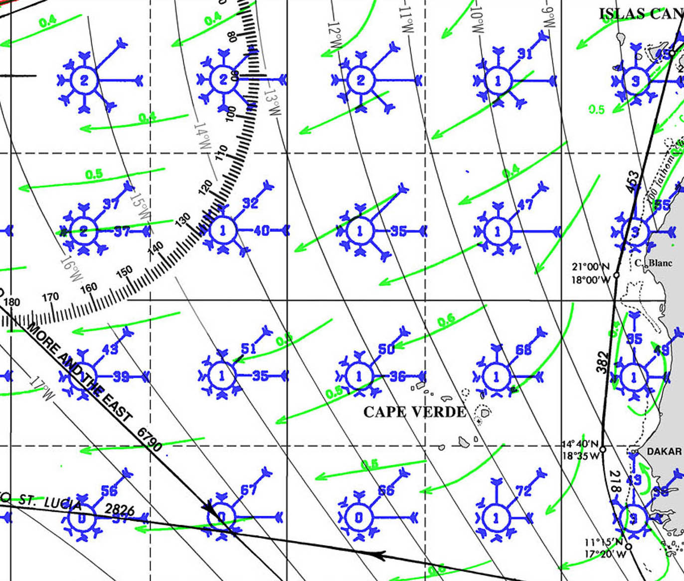
PORTS OF ENTRY CAPE VERDE
Ports of Entry: Mindelo|Sao Vicente, Palmeira|Sal, Praia|Santiago
1. Mindelo, São Vicente
- Location: 16°53.457’N 24°59.210’W
- Description: Mindelo is the most popular port of entry for yachts arriving in Cape Verde. Located on the island of São Vicente, it has a well-equipped marina and is a bustling hub for maritime activities. Customs and immigration are located near the marina, and the process is generally straightforward. Mindelo is known for its vibrant cultural scene and serves as a convenient base for exploring the surrounding islands.
- Contact: +238 232 10 70 / info@marinamindelo.cv
2. Praia, Santiago
- Location: 14°54.423’N 23°30.156’W
- Description: Praia, the capital of Cape Verde, is another important port of entry, located on the island of Santiago. The port is primarily commercial, but there are facilities for yachts to clear customs and immigration. The port is busy, so yacht crews should be prepared for possible delays, especially during peak shipping times. Praia offers full city amenities, including embassies, making it a practical location for handling formalities.
- Contact: +238 261 47 12 / porto.praia@enapor.cv
3. Palmeira, Sal
- Location: 16°45.231’N 22°59.732’W
- Description: Palmeira, located on Sal Island, is a popular port of entry for yachts, especially those arriving from the north. The harbor is sheltered, and customs and immigration officers are usually available to handle formalities. Palmeira is a small, laid-back town with basic amenities. Sal is known for its beautiful beaches and water sports, making it a pleasant first stop in Cape Verde.
- Contact: Local authorities available via VHF Channel 16
4. Tarrafal, Santiago
- Location: 15°16.986’N 23°45.292’W
- Description: Tarrafal, located on the northern coast of Santiago Island, is a smaller, more relaxed port of entry. While it doesn’t have the extensive facilities of Mindelo or Praia, it offers a quieter and more scenic location to handle entry formalities. Customs and immigration services are available, although the process may be slower due to the smaller scale of operations.
- Contact: Local authorities available via VHF Channel 16
5. Sal Rei, Boa Vista
- Location: 16°10.423’N 22°54.964’W
- Description: Sal Rei is the main town on Boa Vista Island and serves as a port of entry for yachts. The anchorage is protected, but there are no marina facilities, so yachts must anchor offshore and dinghy in for formalities. Boa Vista is less developed than other islands, offering a more remote and tranquil experience. Customs and immigration services are available in the town.
- Contact: Local authorities available via VHF Channel 16
Clearing Procedures:
- Documents Required: Passports, crew lists, vessel registration, and clearance from the previous port.
- Process: Upon arrival, proceed to the port’s customs and immigration office to complete the necessary paperwork. Be prepared to present your ship’s papers, crew list, and passports. The process is generally straightforward but can vary slightly depending on the port and local conditions.
- Health and Safety: As of the latest updates, no specific health checks are required beyond standard procedures, but it is advisable to check for any changes in requirements before arrival, especially due to ongoing global health concerns.
These ports of entry offer varied experiences for arriving yachts, from the bustling atmosphere of Mindelo to the more serene setting of Tarrafal. Each port provides an opportunity to explore the rich culture and natural beauty of Cape Verde.
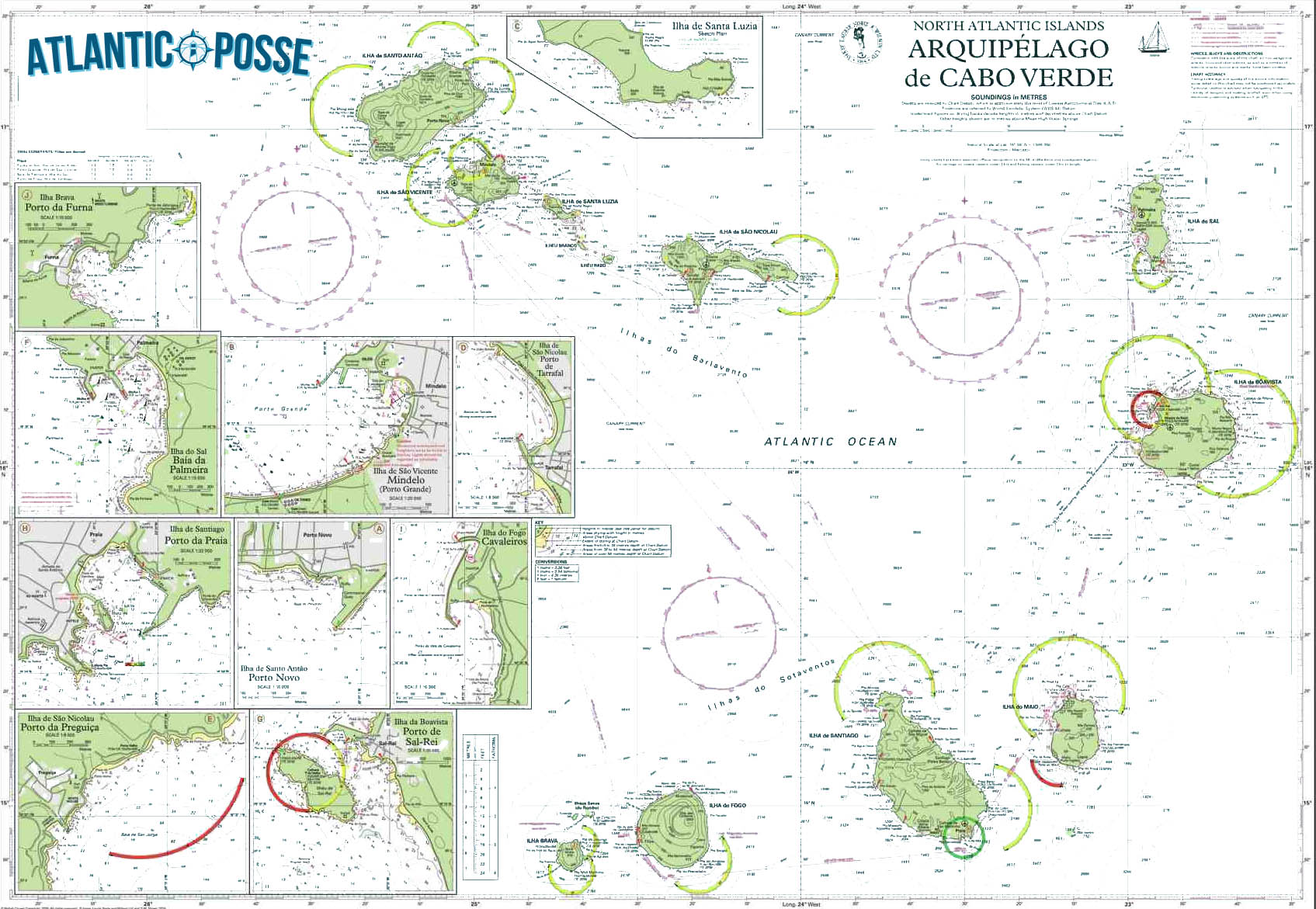
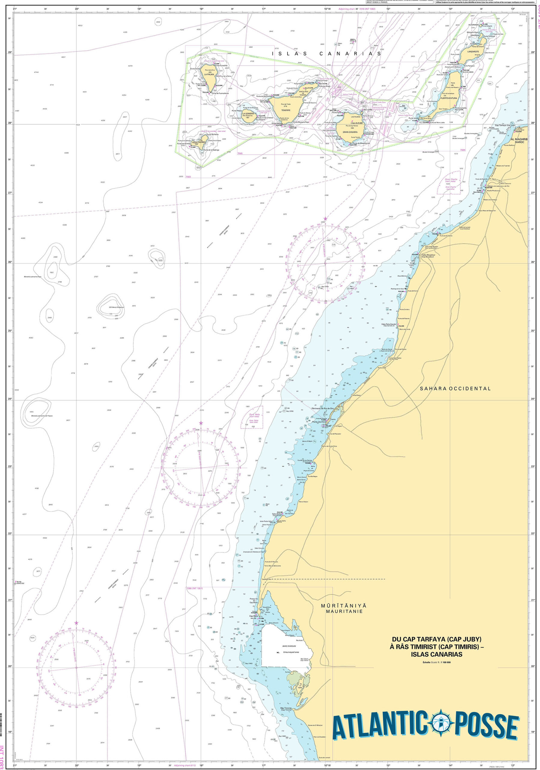
MUST SEE
1. Monte Verde, São Vicente
- Location: 16°52.532’N 24°57.898’W
- Description: Monte Verde is the highest point on São Vicente Island, standing at 750 meters above sea level. The mountain offers panoramic views of the entire island, including the city of Mindelo, the surrounding valleys, and the Atlantic Ocean. The hike to the summit is moderately challenging, taking you through unique flora and volcanic landscapes. The views from the top are breathtaking, especially at sunrise or sunset, where the island’s rugged beauty is fully illuminated. On clear days, you can even catch a glimpse of neighboring islands like Santo Antão.
- Best Time to Visit: November to April, during the dry season, when the skies are clear, and the temperatures are comfortable for hiking.
2. Praia de Santa Maria, Sal
- Location: 16°36.494’N 22°54.320’W
- Description: Praia de Santa Maria is one of Cape Verde’s most famous beaches, located on the island of Sal. The beach stretches for 8 kilometers, with golden sands and turquoise waters that are ideal for swimming, sunbathing, and water sports. The beach is dotted with colorful fishing boats, adding to its charm. Santa Maria town is nearby, offering a lively atmosphere with restaurants, bars, and shops. The beach is also a hub for windsurfing, kiteboarding, and diving, attracting water sports enthusiasts from around the world.
- Best Time to Visit: December to June, when the weather is warm and dry, and the winds are favorable for water sports.
3. Cidade Velha, Santiago
- Location: 14°54.144’N 23°36.221’W
- Description: Cidade Velha, located on Santiago Island, is a UNESCO World Heritage site and the oldest European colonial settlement in the tropics. Founded in 1462, it was the first capital of Cape Verde and played a significant role in the Atlantic slave trade. The town is home to several historical landmarks, including the Royal Fortress of São Filipe, the Church of Our Lady of the Rosary, and the Pelourinho (pillory). Walking through the cobbled streets, you can feel the weight of history and the cultural fusion that defines Cape Verde.
- Best Time to Visit: November to May, when the weather is dry and cool, making it ideal for exploring historical sites.
4. Pico do Fogo, Fogo
- Location: 14°57.892’N 24°21.530’W
- Description: Pico do Fogo is an active stratovolcano and the highest peak in Cape Verde, reaching an altitude of 2,829 meters. Located on Fogo Island, the volcano last erupted in 2014, leaving behind a dramatic landscape of black lava fields and ash-covered slopes. The hike to the summit is challenging but rewarding, offering unparalleled views of the island and beyond. The surrounding Cha das Caldeiras is a small village where locals cultivate grapes and coffee in the fertile volcanic soil.
- Best Time to Visit: November to February, during the cooler months, when the weather is most favorable for hiking.
5. Santo Antão, Santo Antão
- Location: 17°06.041’N 25°09.501’W
- Description: Santo Antão is the greenest and most mountainous island in Cape Verde, known for its stunning landscapes and traditional villages. The island is a hiker’s paradise, with trails that wind through lush valleys, terraced fields, and rugged cliffs. The Ribeira Grande valley, the Paul Valley, and the coastal village of Ponta do Sol are some of the highlights. The island’s remote and untouched beauty makes it a perfect destination for those looking to experience the natural side of Cape Verde.
- Best Time to Visit: October to May, during the dry season, when the weather is mild, and the trails are accessible.
6. Salinas de Pedra de Lume, Sal
- Location: 16°45.332’N 22°55.024’W
- Description: Salinas de Pedra de Lume is a unique salt crater located on the island of Sal. The crater was formed by the collapse of a volcanic cone, and its basin is filled with saltwater that evaporates, leaving behind thick salt deposits. The site has been used for salt production since the 18th century. Visitors can float in the highly saline water, which is said to have therapeutic properties, similar to the Dead Sea. The surrounding landscape is otherworldly, with white salt pans contrasting against the volcanic rocks.
- Best Time to Visit: November to April, when the weather is cooler and more comfortable for exploring the salt flats.
7. Baía do Tarrafal, Santiago
- Location: 15°16.818’N 23°45.235’W
- Description: Baía do Tarrafal is a picturesque bay located on the northern coast of Santiago Island. The bay is known for its beautiful beach, clear waters, and palm trees swaying in the breeze. Tarrafal is a popular spot for swimming, snorkeling, and relaxing on the beach. The town of Tarrafal has a relaxed, laid-back atmosphere, with a small market, local restaurants, and friendly locals. The bay is also historically significant, as it was once home to a Portuguese concentration camp during the colonial era.
- Best Time to Visit: November to May, when the weather is dry and sunny, making it perfect for beach activities.
8. Serra Malagueta, Santiago
- Location: 15°08.437’N 23°39.472’W
- Description: Serra Malagueta is a mountain range located in the northern part of Santiago Island. The range is part of the Serra Malagueta Natural Park, which covers an area of 774 hectares and is home to a diverse array of flora and fauna. The park’s rugged terrain, with peaks reaching up to 1,064 meters, offers excellent hiking opportunities, with trails that take you through lush forests, deep valleys, and panoramic viewpoints. The park is also an important conservation area, protecting several endemic species.
- Best Time to Visit: November to April, when the weather is cool and the visibility is clear, making it ideal for hiking and wildlife spotting.
9. Praia de Chaves, Boa Vista
- Location: 16°10.443’N 22°55.223’W
- Description: Praia de Chaves is a stunning beach on Boa Vista Island, known for its vast expanse of golden sands and crystal-clear waters. The beach is part of the Morro de Areia Nature Reserve, which protects the island’s unique coastal dune ecosystems. Praia de Chaves is an ideal spot for sunbathing, swimming, and long walks along the shore. The beach is relatively undeveloped, offering a sense of tranquility and seclusion. The dunes behind the beach are a striking feature, and you can often see local wildlife, such as crabs and seabirds.
- Best Time to Visit: November to June, during the dry season, when the weather is warm and the sea conditions are calm.
10. Monte Gordo, São Nicolau
- Location: 16°36.533’N 24°17.945’W
- Description: Monte Gordo is the highest peak on the island of São Nicolau, standing at 1,312 meters. The mountain is part of the Monte Gordo Natural Park, which protects a diverse range of ecosystems, from humid forests to arid plains. The hike to the summit of Monte Gordo is a popular activity, offering breathtaking views of the island and the surrounding ocean. The park is also home to a variety of endemic plant species and birds, making it a haven for nature lovers. The traditional villages at the base of the mountain provide a glimpse into the island’s rural life.
- Best Time to Visit: October to April, when the weather is cool and the visibility is clear, making it ideal for hiking and birdwatching.
11. Ponta Preta, Sal
- Location: 16°41.343’N 22°55.234’W
- Description: Ponta Preta is a famous beach on the island of Sal, known for its powerful waves and pristine sands. It is one of the best spots in Cape Verde for surfing, windsurfing, and kiteboarding, attracting water sports enthusiasts from around the world. The beach is also a great place to watch sunsets, with the sun dipping into the Atlantic Ocean, casting a golden glow over the waves. Ponta Preta is part of the island’s wild coastline, offering a sense of isolation and raw natural beauty.
- Best Time to Visit: November to June, when the winds are strong, creating ideal conditions for surfing and other water sports.
12. Ribeira Grande, Santo Antão
- Location: 17°03.412’N 25°05.622’W
- Description: Ribeira Grande is a picturesque town on the island of Santo Antão, nestled in a lush valley surrounded by mountains. The town is the main hub for exploring the island’s dramatic landscapes, including the famous Ribeira Grande valley. The valley is a patchwork of terraced fields, banana plantations, and sugarcane, irrigated by a network of levadas (water channels). The town itself has a charming colonial feel, with cobblestone streets, colorful buildings, and a lively market. Ribeira Grande is the perfect base for hiking, exploring local culture, and experiencing the island’s agricultural traditions.
- Best Time to Visit: October to May, when the weather is mild, and the valley is green and lush.
13. Tarrafal de Monte Trigo, Santo Antão
- Location: 17°02.781’N 25°13.614’W
- Description: Tarrafal de Monte Trigo is a small fishing village on the western coast of Santo Antão, known for its remote and unspoiled beauty. The village is surrounded by dramatic cliffs and volcanic landscapes, with a black sand beach that stretches along the coast. Tarrafal de Monte Trigo is a great place to unwind and enjoy the simple pleasures of life, such as fresh seafood, local hospitality, and the sound of the waves. The village is also a starting point for hikes into the rugged interior of Santo Antão, including the ascent of Monte Trigo, a dormant volcano.
- Best Time to Visit: November to May, when the weather is dry and cool, ideal for exploring the village and hiking.
14. Ribeira da Torre, Santo Antão
- Location: 17°03.239’N 25°04.548’W
- Description: Ribeira da Torre is one of the most beautiful valleys on Santo Antão, known for its towering cliffs, cascading waterfalls, and lush greenery. The valley is dotted with small villages, terraced fields, and tropical fruit trees, creating a stunning mosaic of colors and textures. The hike through Ribeira da Torre is one of the most popular on the island, offering a mix of challenging terrain and breathtaking scenery. The valley is also home to several endemic plant species, making it a haven for botanists and nature lovers.
- Best Time to Visit: October to May, when the valley is at its greenest, and the weather is mild, perfect for hiking and photography.
15. Santa Luzia Island
- Location: 16°45.454’N 24°45.678’W
- Description: Santa Luzia is the smallest of Cape Verde’s inhabited islands, located between São Vicente and São Nicolau. The island is uninhabited, making it a pristine and untouched natural paradise. Santa Luzia is part of a marine reserve, protecting its unique ecosystems, including dunes, rocky cliffs, and coral reefs. The island’s beaches are some of the most beautiful in Cape Verde, with soft white sands and clear turquoise waters. Santa Luzia is also a haven for birdwatchers, with several endemic species found on the island.
- Best Time to Visit: November to June, during the dry season, when the seas are calm, making it easier to reach the island by boat.
16. Viana Desert, Boa Vista
- Location: 16°09.621’N 22°50.672’W
- Description: The Viana Desert is a striking desert landscape located on the island of Boa Vista. The desert is formed by sands blown in from the Sahara, creating a vast expanse of dunes that stretch for miles. The Viana Desert is a unique feature of Cape Verde, offering a surreal and otherworldly experience. Visitors can explore the dunes on foot or by quad bike, taking in the stark beauty of the desert and the play of light and shadow on the sand. The desert is also home to some unique plant species, adapted to the harsh conditions.
- Best Time to Visit: November to April, when the weather is cooler, making it more comfortable to explore the desert.
17. Furna, Brava
- Location: 14°52.876’N 24°42.965’W
- Description: Furna is a small, picturesque village located on the island of Brava, the smallest of Cape Verde’s inhabited islands. The village is perched on a steep hillside overlooking a sheltered bay, offering stunning views of the Atlantic Ocean. Furna is known for its traditional Cape Verdean architecture, with brightly painted houses and cobblestone streets. The village is also a gateway to exploring Brava’s lush interior, with hiking trails that take you through terraced fields, forests, and small villages. Brava is often called the “island of flowers” due to its abundant flora.
- Best Time to Visit: November to April, when the weather is mild and the flowers are in bloom, making it a perfect time to explore the island.
18. Praia de São Pedro, São Vicente
- Location: 16°52.123’N 25°04.934’W
- Description: Praia de São Pedro is a beautiful beach located near the village of São Pedro on São Vicente Island. The beach is known for its clear waters, golden sands, and strong winds, making it a popular spot for windsurfing and kitesurfing. The beach is relatively uncrowded, offering a tranquil setting for relaxation and water sports. The village of São Pedro is small and charming, with a laid-back atmosphere and friendly locals. The beach is also a great place to watch the local fishermen at work, bringing in their daily catch.
- Best Time to Visit: November to June, when the winds are strong, creating ideal conditions for windsurfing and kitesurfing.
19. Serra da Malagueta, Santiago
- Location: 15°08.399’N 23°39.473’W
- Description: Serra da Malagueta is a mountain range located in the northern part of Santiago Island, forming part of the Serra Malagueta Natural Park. The range is known for its rugged terrain, deep valleys, and diverse ecosystems, including forests, savannas, and shrublands. The park is home to several endemic species of plants and animals, making it an important conservation area. The hike to the summit of Serra da Malagueta offers breathtaking views of the island and the surrounding ocean. The park is also a great place for birdwatching, with several rare species found in the area.
- Best Time to Visit: November to April, when the weather is cool and the visibility is clear, making it ideal for hiking and birdwatching.
20. São Filipe, Fogo
- Location: 14°53.687’N 24°29.231’W
- Description: São Filipe is the main town on the island of Fogo, known for its colonial architecture, cobblestone streets, and stunning views of the ocean. The town is built on a steep slope overlooking the sea, with the imposing Pico do Fogo volcano as a backdrop. São Filipe is a great place to experience Cape Verdean culture, with lively markets, traditional music, and local festivals. The town is also the gateway to exploring the rest of Fogo, including the Cha das Caldeiras and the ascent of Pico do Fogo.
- Best Time to Visit: November to April, when the weather is mild, making it ideal for exploring the town and the surrounding areas.
SERVICES
1. Marinas and Moorings
- Mindelo Marina (São Vicente): The main marina in Cape Verde, offering around 120 berths for yachts. Facilities include water, electricity, Wi-Fi, laundry services, and a chandlery. Mindelo Marina is the primary hub for yachts crossing the Atlantic.
- Anchorage: Available at several locations, including Sal Rei (Boa Vista), Palmeira (Sal), Tarrafal (Santiago), and Porto Grande Bay (São Vicente). These anchorages are generally well-protected, but facilities vary and may be limited.
2. Fuel and Water
- Fuel: Diesel and gasoline are available in Mindelo (São Vicente), Praia (Santiago), Palmeira (Sal), and some other ports. In smaller locations, fueling may be done directly from fuel stations near the port or via jerry cans.
- Water: Available at Mindelo Marina and some ports like Praia and Palmeira. In more remote anchorages, water may be scarce, and yachts should plan accordingly.
3. Chandlery and Supplies
- Chandlery: The best-stocked chandlery is in Mindelo, offering a range of boat parts, maintenance supplies, and marine equipment. Supplies may be more limited on other islands, so it’s advisable to stock up in Mindelo.
- Provisioning: Basic groceries and supplies can be found in most towns, but Mindelo and Praia offer the best options for fresh produce, meats, and other essentials.
4. Boat Repair and Maintenance
- Mindelo (São Vicente): The primary location for boat repairs and maintenance, including engine repairs, electrical work, sail repairs, and general maintenance. There are skilled technicians available, and the marina can assist in coordinating services.
- Limited Services: In other locations like Praia and Palmeira, basic repairs and maintenance may be available, but it’s advisable to address any significant issues in Mindelo.
5. Customs and Immigration
- Ports of Entry: Customs and immigration services are available at key ports of entry, including Mindelo (São Vicente), Praia (Santiago), Palmeira (Sal), and Sal Rei (Boa Vista). These services include vessel clearance, visa processing, and crew formalities.
6. Waste Disposal
- Waste and Recycling: Waste disposal facilities are available at Mindelo Marina and in some ports like Praia and Palmeira. Recycling options are limited, so cruisers are encouraged to manage waste responsibly, minimizing plastics and other non-biodegradable materials.
7. Internet and Communications
- Wi-Fi: Available at Mindelo Marina and in many cafes and restaurants in larger towns. Mobile SIM cards and data plans are available from local providers, with 4G coverage in most populated areas.
- VHF Communication: VHF Channel 16 is monitored in all major ports for maritime communication, and local authorities can be contacted for assistance.
8. Medical and Emergency Services
- Medical Facilities: Available in larger towns like Mindelo and Praia, including hospitals and pharmacies. Medical care in more remote locations may be limited, so it’s advisable to have a well-stocked first aid kit and any necessary medications on board.
- Emergency Services: Coast Guard services are available and can be contacted via VHF for maritime emergencies.
9. Weather and Navigation Information
- Weather Forecasting: Weather forecasts are available through the marina office in Mindelo, online, or via VHF. Reliable weather information is crucial for safe passage planning, especially during the Atlantic hurricane season.
- Navigation Charts: Digital and paper charts covering Cape Verde are available at the chandlery in Mindelo. Electronic navigation is widely used, but it’s advisable to have up-to-date charts on board.
10. Transportation and Logistics
- Transport: Taxi services are available in major towns, and inter-island travel can be arranged via ferries or domestic flights. Logistics support, including freight forwarding, can be arranged through service providers in Mindelo and Praia.
These marine services ensure that yachts visiting Cape Verde can find the essential support they need, particularly in more developed locations like Mindelo. However, it’s important to plan and prepare when visiting more remote islands, where services may be limited.