
 Introduction
Puerto Rico, an enchanting Caribbean island, offers a mesmerizing blend of stunning coastlines, rich culture, and vibrant marine life. For cruising enthusiasts, circumnavigating Puerto Rico presents a thrilling maritime adventure. This guide provides an in-depth look at weather patterns, currents, and prime anchorages to help you navigate and enjoy your journey around the island.
Weather Patterns
Understanding Puerto Rico’s weather is crucial for a successful circumnavigation. The island enjoys a tropical marine climate, characterized by year-round warm temperatures and moderate to high humidity. Here’s a closer look at the seasonal weather patterns:
Winter (December to April)
- Temperature: Average daytime temperatures range from 75°F to 85°F (24°C to 29°C).
- Wind: The prevailing trade winds from the northeast are steady, making this period ideal for sailing.
- Rainfall: Minimal rainfall with occasional showers. The driest months are February and March.
- Sea Conditions: Generally calm seas with slight to moderate swells.
Summer (May to November)
- Temperature: Average daytime temperatures range from 80°F to 90°F (27°C to 32°C).
- Wind: Winds are less predictable and can be variable, with a greater likelihood of calms and sudden gusts.
- Rainfall: Higher precipitation, especially in August and September. Afternoon thunderstorms are common.
- Hurricane Season: Peaks from August to October. Monitoring weather forecasts and having a hurricane plan is essential.
Ocean Currents
Navigating Puerto Rico’s waters requires an understanding of the ocean currents that influence the island:
The Caribbean Current
- Direction: Flows westward along the southern coast of Puerto Rico.
- Speed: Generally ranges from 0.5 to 2 knots, but can reach up to 3 knots in certain areas.
- Impact: Provides a natural boost for vessels heading west but can pose challenges when sailing eastward.
The Antilles Current
- Direction: Flows northwestward, affecting the northern coast of Puerto Rico.
- Speed: Typically 0.5 to 1 knot.
- Impact: Can aid in northward navigation but requires attention when heading south.
Tidal Currents
- Variation: Tidal currents around Puerto Rico are generally weak, with tidal ranges rarely exceeding 1.5 feet.
- Consideration: Localized tidal currents in bays and harbors may affect docking and anchoring.
Prime Anchorages
Puerto Rico boasts numerous idyllic anchorages, each offering unique scenery and facilities. Here are some of the top spots to consider during your circumnavigation:
1. San Juan Bay
- Location: Northern coast.
- Coordinates: 18°27.5’N, 66°06.1’W
- Highlights: Historic Old San Juan, vibrant nightlife, and extensive marina facilities. The bay is well-protected and provides excellent holding.
2. Fajardo
- Location: Northeastern coast.
- Coordinates: 18°20.1’N, 65°38.0’W
- Highlights: Gateway to the Spanish Virgin Islands, numerous marinas, and clear waters. Ideal for provisioning and repairs.
3. Vieques Island
- Location: East of the main island.
- Coordinates: 18°08.3’N, 65°26.9’W
- Highlights: Bioluminescent Bay, pristine beaches, and secluded anchorages. A tranquil spot with limited facilities but stunning natural beauty.
4. Culebra Island
- Location: East of the main island.
- Coordinates: 18°18.1’N, 65°17.8’W
- Highlights: Flamenco Beach, snorkeling at Carlos Rosario, and friendly local vibe. Sheltered anchorages with mooring buoys available.
5. Ponce
- Location: Southern coast.
- Coordinates: 17°58.1’N, 66°37.1’W
- Highlights: La Guancha Boardwalk, historic district, and the vibrant local culture. The anchorage is well-protected with convenient access to the city.
6. Boquerón Bay
- Location: Southwestern coast.
- Coordinates: 18°01.5’N, 67°10.3’W
- Highlights: Popular weekend destination, lively nightlife, and excellent seafood. The bay offers good holding and protection from northerly swells.
7. Rincón
- Location: Western coast.
- Coordinates: 18°20.8’N, 67°15.7’W
- Highlights: Renowned surf spots, beautiful sunsets, and a laid-back atmosphere. Limited facilities but a charming stop for relaxation.
Navigational Tips
Planning and Preparation
- Charts and Guides: Ensure you have updated nautical charts and cruising guides specific to Puerto Rico.
- Weather Updates: Regularly monitor weather forecasts and marine conditions.
- Hurricane Plan: Have a clear plan for hurricane season, including identified safe harbors.
Sailing Techniques
- Trade Winds: Utilize the steady trade winds during the winter months for smooth sailing.
- Current Management: Plan passages considering the direction and speed of ocean currents to optimize your route.
- Anchoring: Use ample scope when anchoring, and double-check your holding, especially in areas with grassy or rocky bottoms.
MARINAS
1. Club Nautico de San Juan
- Location: San Juan
- Coordinates: 18°27.8’N, 66°05.7’W
- Description: Club Nautico de San Juan, located in the heart of San Juan Bay, offers world-class amenities and services for yachts and sailing vessels. This marina is known for its high standards, including 120 slips, fuel dock, and 24-hour security. The marina is a short distance from Old San Juan, offering access to historical sites, restaurants, and shopping. It hosts numerous international sailing events and fishing tournaments.
- Contact Info:
- Phone: +1 787-722-0177
- Email: info@nauticodesanjuan.com
- Website: nauticodesanjuan.com
2. Puerto Del Rey Marina
- Location: Fajardo
- Coordinates: 18°17.4’N, 65°38.0’W
- Description: Puerto Del Rey Marina is the largest marina in the Caribbean, offering over 1,000 wet slips and 400 dry stack spaces. Located on the eastern coast, it serves as a gateway to the Spanish Virgin Islands. The marina provides extensive services, including repairs, fueling, provisioning, and a yacht club. Its state-of-the-art facilities and comprehensive amenities make it a preferred choice for both transient and long-term boaters.
- Contact Info:
- Phone: +1 787-860-1000
- Email: info@puertodelrey.com
- Website: puertodelrey.com
3. Villa Marina Yacht Harbour
- Location: Fajardo
- Coordinates: 18°20.0’N, 65°37.5’W
- Description: Villa Marina Yacht Harbour is a premier marina offering 300 slips for yachts up to 120 feet. It features amenities such as fueling services, a marine store, restaurants, and a swimming pool. Conveniently located near El Yunque National Forest and Culebra, it’s a popular stop for those exploring the eastern Caribbean. The marina is known for its friendly staff and well-maintained facilities.
- Contact Info:
- Phone: +1 787-863-4990
- Email: info@villamarinayachtharbour.com
- Website: villamarinayachtharbour.com
4. Puerto Real Marina
- Location: Cabo Rojo
- Coordinates: 18°04.5’N, 67°11.1’W
- Description: Puerto Real Marina, located on the southwestern coast, offers a serene setting with 180 slips. It provides services such as fuel, repairs, and provisioning. The marina is an ideal starting point for exploring the nearby islands of Mona and Desecheo. It boasts a tranquil environment with excellent fishing opportunities, making it a favorite among sport fishermen.
- Contact Info:
- Phone: +1 787-851-2110
- Email: info@puertorealmarina.com
- Website: puertorealmarina.com
5. Puerto Bahia Marina & Resort
- Location: Samaná, Dominican Republic (for context, it’s near Puerto Rico)
- Coordinates: 19°11.5’N, 69°20.3’W
- Description: Puerto Bahia Marina & Resort is located near Puerto Rico and offers a luxurious retreat with 107 slips for yachts up to 150 feet. The marina is part of a resort complex that includes a hotel, spa, restaurants, and pools. It provides top-notch services and is known for its scenic views and elegant atmosphere. It’s a convenient stop for yachts traveling between Puerto Rico and the Dominican Republic.
- Contact Info:
- Phone: +1 809-503-6363
- Email: info@puertobahiamarina.com
- Website: puertobahiamarina.com
6. Sunbay Marina
- Location: Fajardo
- Coordinates: 18°19.7’N, 65°38.1’W
- Description: Sunbay Marina in Fajardo offers 287 slips and a wide range of services, including fuel, repairs, and provisioning. The marina is strategically located near the beautiful islands of Culebra and Vieques. It provides a safe harbor with 24-hour security and modern facilities. Sunbay Marina is popular among sailors and cruisers looking for a well-equipped base to explore the eastern Caribbean.
- Contact Info:
- Phone: +1 787-863-0313
- Email: info@sunbaymarina.com
- Website: sunbaymarina.com
7. Ponce Yacht & Fishing Club
- Location: Ponce
- Coordinates: 17°57.5’N, 66°37.3’W
- Description: Ponce Yacht & Fishing Club is situated in the southern city of Ponce and offers 160 slips. The club is known for its vibrant community and range of activities, including fishing tournaments and social events. It features a clubhouse, restaurant, and swimming pool, making it a welcoming spot for boaters. The marina provides easy access to the historic and cultural attractions of Ponce.
- Contact Info:
- Phone: +1 787-842-9003
- Email: info@ponceyachtclub.com
- Website: ponceyachtclub.com
8. Marina Pescaderia
- Location: Cabo Rojo
- Coordinates: 18°04.8’N, 67°11.3’W
- Description: Marina Pescaderia, located in the picturesque town of Cabo Rojo, offers 98 slips and is known for its personalized service and friendly atmosphere. The marina provides essential services, including fueling, repairs, and a restaurant. It is a favorite among cruisers for its proximity to excellent fishing grounds and the beautiful beaches of Cabo Rojo.
- Contact Info:
- Phone: +1 787-717-3638
- Email: info@marinapescaderia.com
- Website: marinapescaderia.com
9. Puerto Chico Marina
- Location: Fajardo
- Coordinates: 18°19.9’N, 65°38.0’W
- Description: Puerto Chico Marina in Fajardo is a full-service marina offering 180 slips. It is ideally located for exploring the nearby islands of Culebra and Vieques. The marina offers a range of amenities, including a fuel dock, ship store, and repair services. It is known for its friendly staff and convenient location near restaurants and shops.
- Contact Info:
- Phone: +1 787-863-0613
- Email: info@puertochicomarina.com
- Website: puertochicomarina.com
10. Marina de Salinas
- Location: Salinas
- Coordinates: 17°57.0’N, 66°17.4’W
- Description: Marina de Salinas, located on the southern coast, offers 150 slips and a peaceful setting. The marina provides services such as fuel, repairs, and a restaurant. It is a popular stop for cruisers due to its serene environment and close-knit community. The marina offers easy access to the mangrove-lined coast and nearby natural attractions.
- Contact Info:
- Phone: +1 787-824-3185
- Email: info@marinadesalinas.com
- Website: marinadesalinas.com
11. Palmas del Mar Yacht Club
- Location: Humacao
- Coordinates: 18°04.3’N, 65°47.9’W
- Description: Located in the upscale Palmas del Mar community, this marina offers 162 slips and caters to luxury yachts and sailboats. It provides high-end facilities including fuel, provisioning, and access to the resort’s amenities such as golf, tennis, and fine dining.
- Contact Info:
- Phone: +1 787-285-0155
- Email: info@palmasdelmaryachtclub.com
- Website: palmasdelmaryachtclub.com
12. Isleta Marina
- Location: Fajardo
- Coordinates: 18°20.4’N, 65°37.7’W
- Description: Isleta Marina offers 300 slips and is located on a private island, providing a secluded and exclusive experience. The marina offers full services including fuel, repairs, and a restaurant. It’s a favorite for those seeking a private and secure environment.
- Contact Info:
- Phone: +1 787-860-1000
- Email: info@isletamarina.com
- Website: isletamarina.com
13. Marina Puerto Chico
- Location: Fajardo
- Coordinates: 18°19.9’N, 65°38.0’W
- Description: A well-equipped marina with 180 slips, offering amenities such as fuel, ship store, and repair services. It is ideally located for exploring the nearby islands of Culebra and Vieques.
- Contact Info:
- Phone: +1 787-863-0613
- Email: info@marinapuertochico.com
- Website: marinapuertochico.com
14. Marina Pescadería
- Location: Puerto Real, Cabo Rojo
- Coordinates: 18°04.8’N, 67°11.3’W
- Description: This marina offers 98 slips and is known for its personalized service and friendly atmosphere. It provides essential services, including fueling, repairs, and a restaurant.
- Contact Info:
- Phone: +1 787-717-3638
- Email: info@marinapescaderia.com
- Website: marinapescaderia.com
15. Marina Puerto del Rey
- Location: Fajardo
- Coordinates: 18°17.4’N, 65°38.0’W
- Description: The largest marina in the Caribbean, offering over 1,000 wet slips and 400 dry stack spaces. It serves as a gateway to the Spanish Virgin Islands.
- Contact Info:
- Phone: +1 787-860-1000
- Email: info@puertodelrey.com
- Website: puertodelrey.com
16. Marina Parguera
- Location: La Parguera
- Coordinates: 17°58.9’N, 67°02.1’W
- Description: A smaller marina located in the scenic fishing village of La Parguera. Known for its vibrant local culture and excellent access to nearby cays and bioluminescent bay.
- Contact Info:
- Phone: +1 787-899-1660
- Email: info@marinaparguera.com
- Website: marinaparguera.com
17. Seaborne Marina
- Location: Isla Grande, San Juan
- Coordinates: 18°27.8’N, 66°05.7’W
- Description: Located near the Isla Grande Airport, this marina offers a convenient location for those flying in or out of San Juan. It provides a range of services including fuel and repairs.
- Contact Info:
- Phone: +1 787-725-2517
- Email: info@seabornemarina.com
- Website: seabornemarina.com
18. Yacht Club Costa del Sol
- Location: Salinas
- Coordinates: 17°57.0’N, 66°17.4’W
- Description: A smaller, family-oriented marina offering basic amenities and a close-knit community feel. It’s popular among local boaters and those looking for a quieter place to dock.
- Contact Info:
- Phone: +1 787-824-3185
- Email: info@yachtclubcostadelsol.com
- Website: yachtclubcostadelsol.com
WEATHER PUERTO RICO
MAIN LOCAL WEATHER WEBSITE PUERTO RICO
SEVERE WEATHER PUERTO RICO
PILOT CHARTS PUERTO RICO CLIMATOLOGY
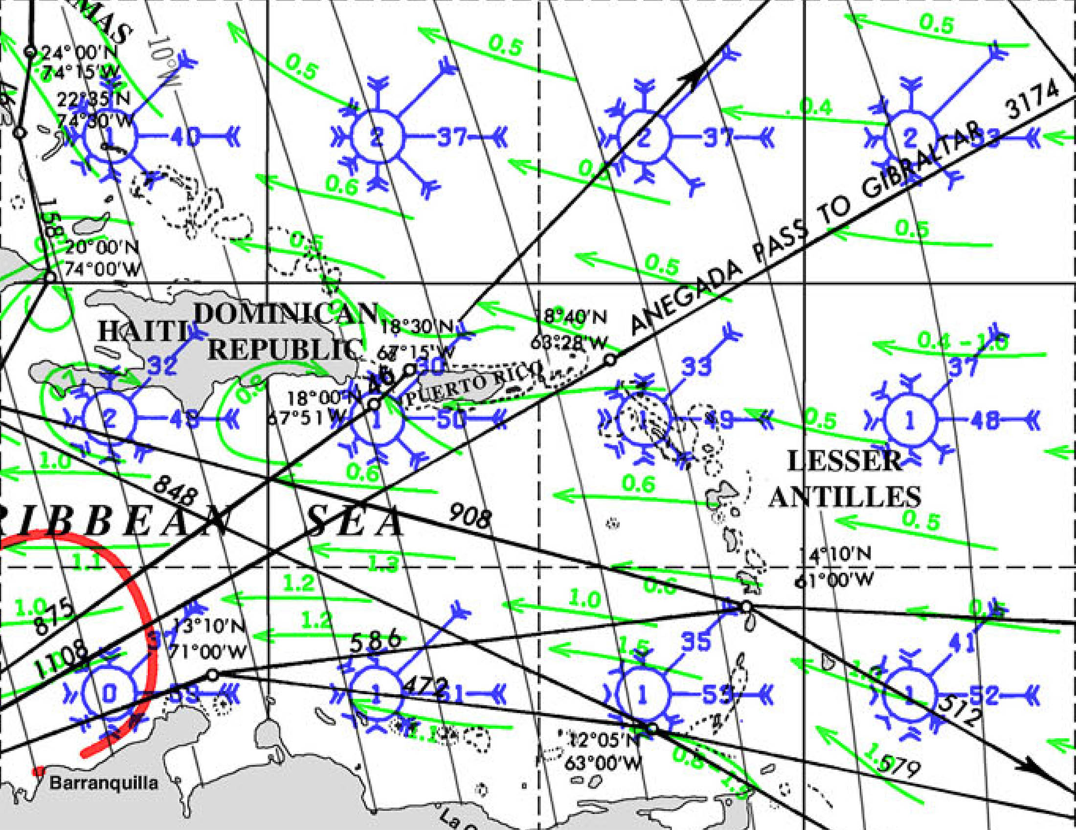
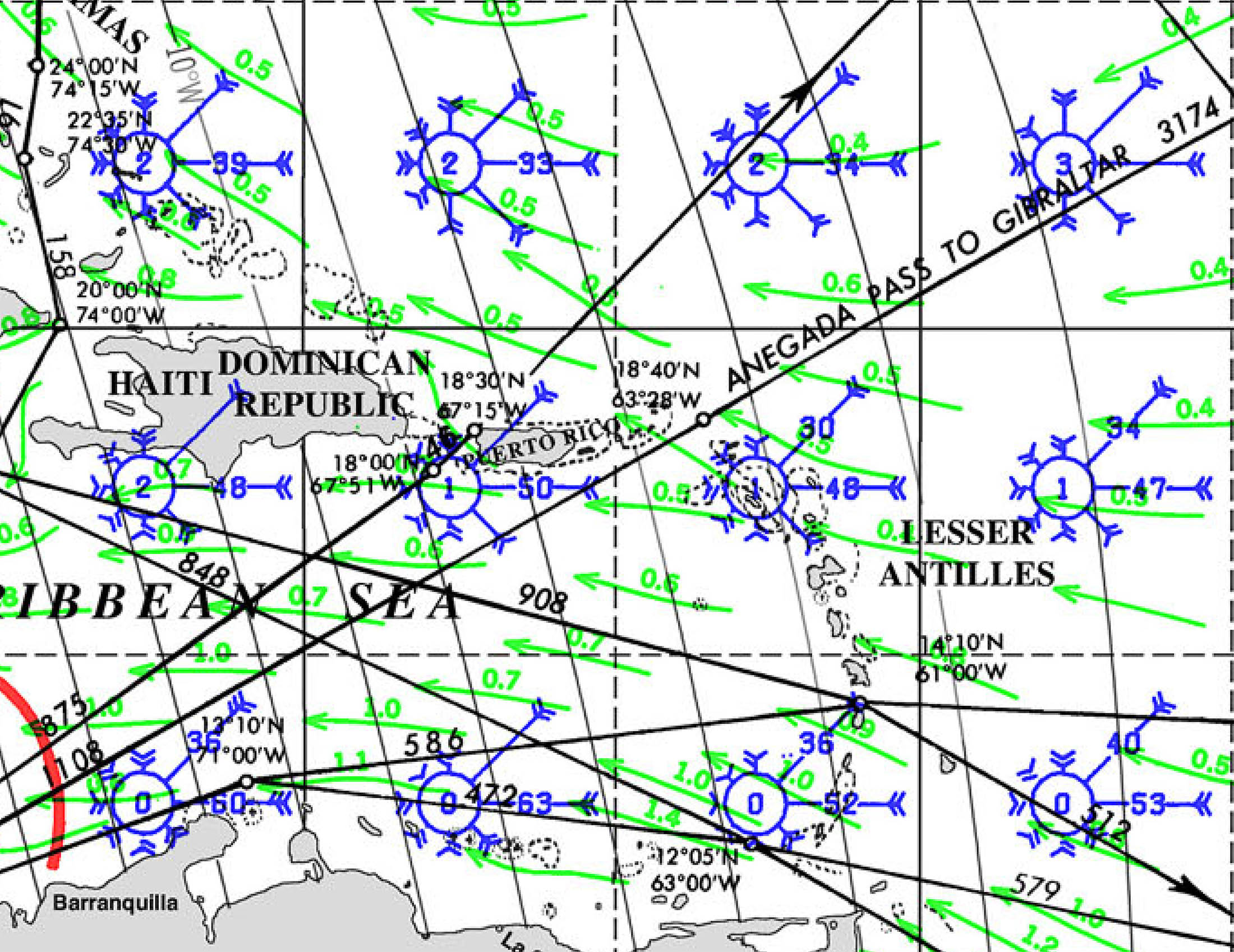
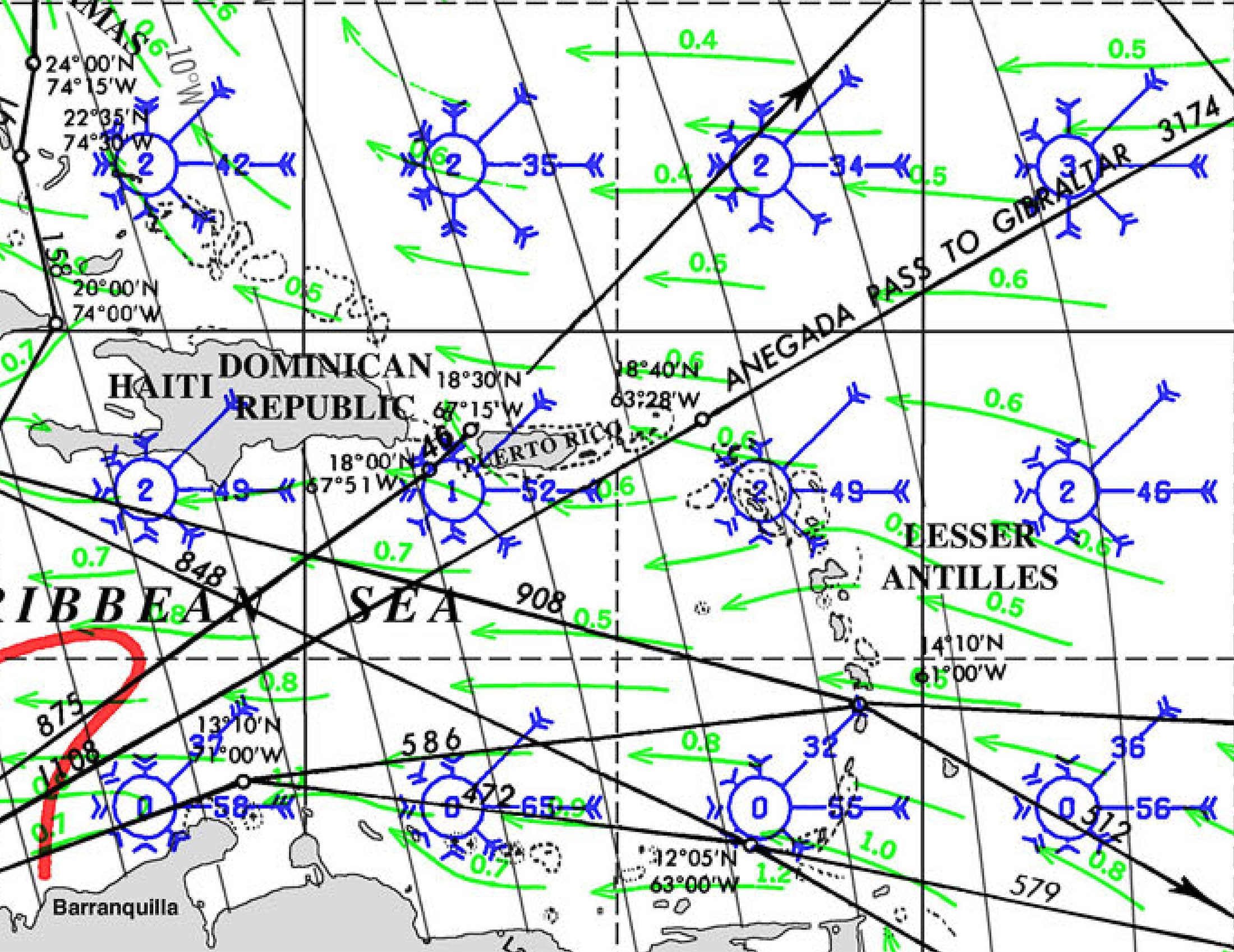
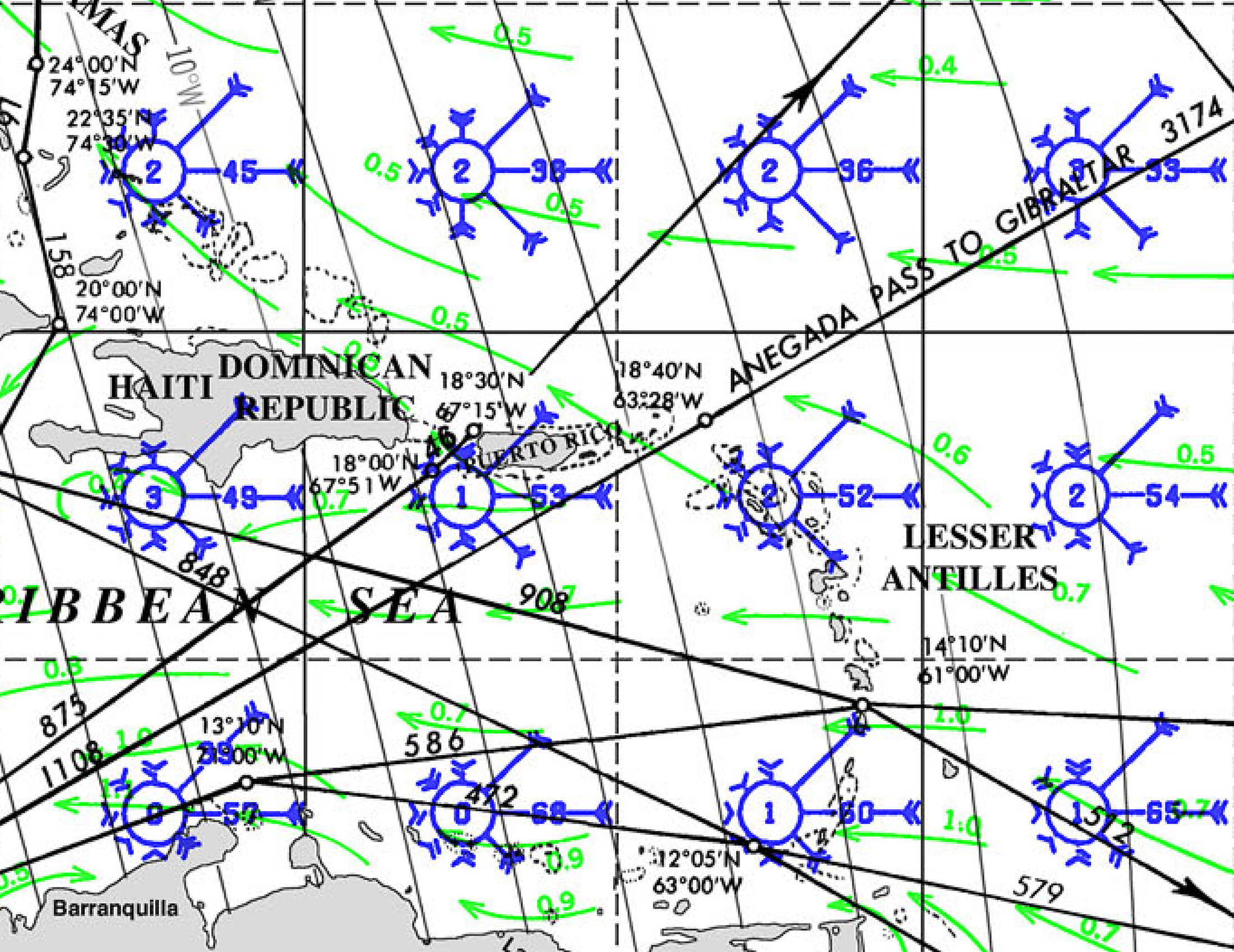
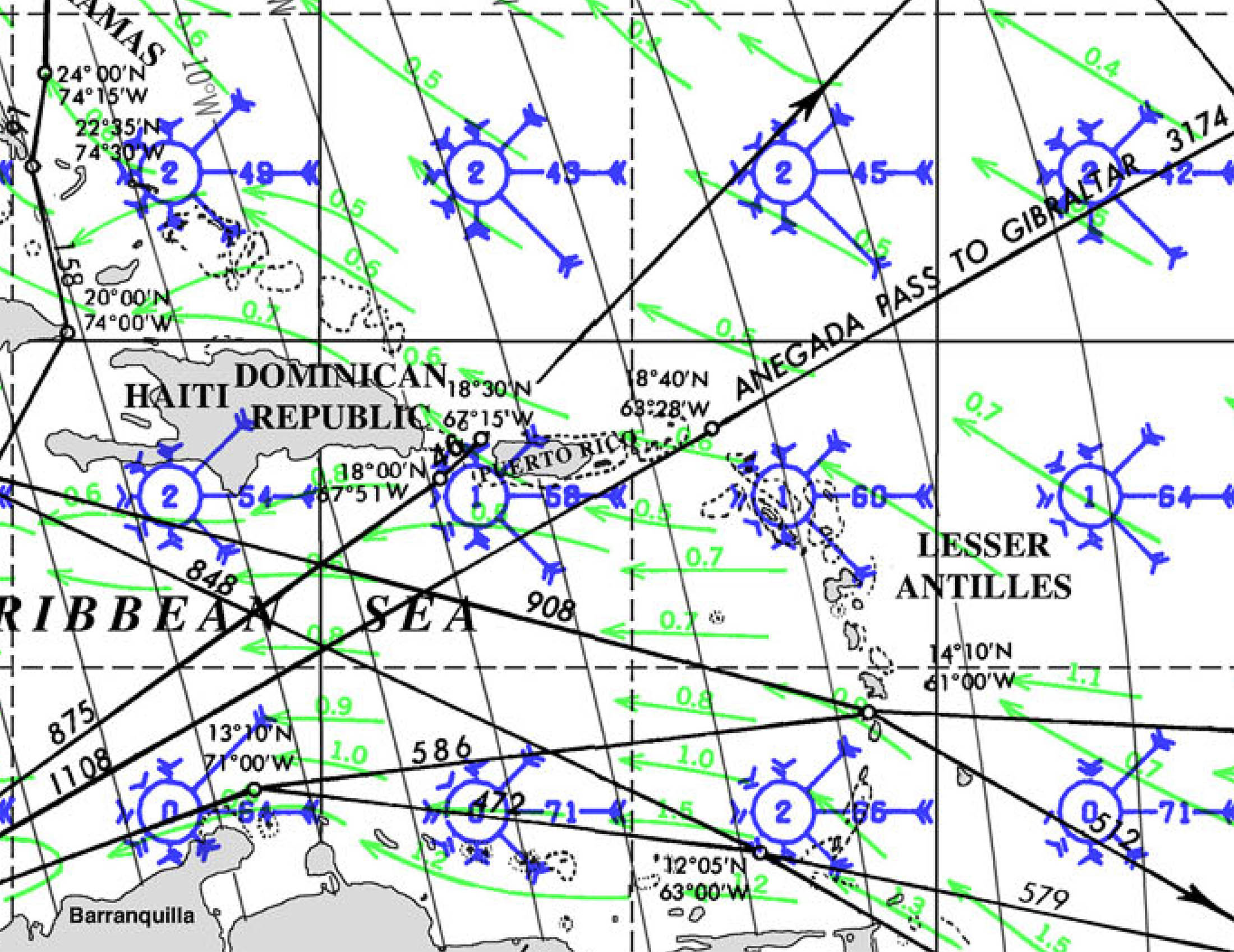
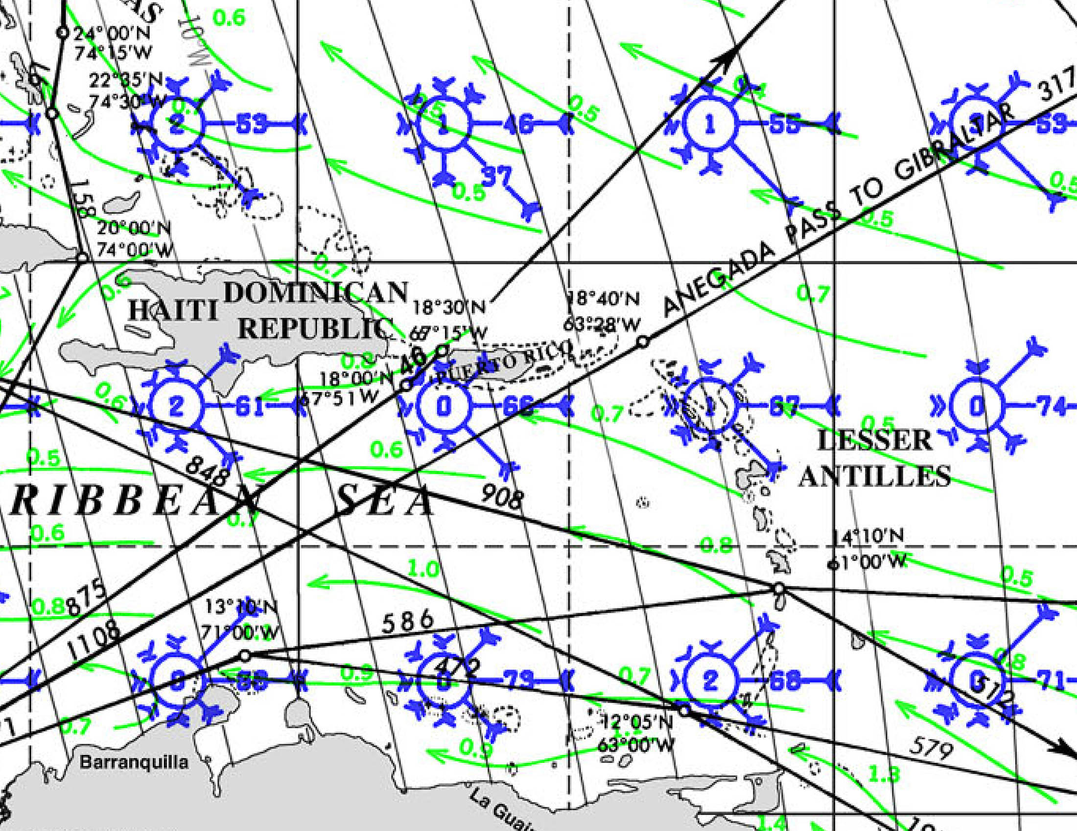
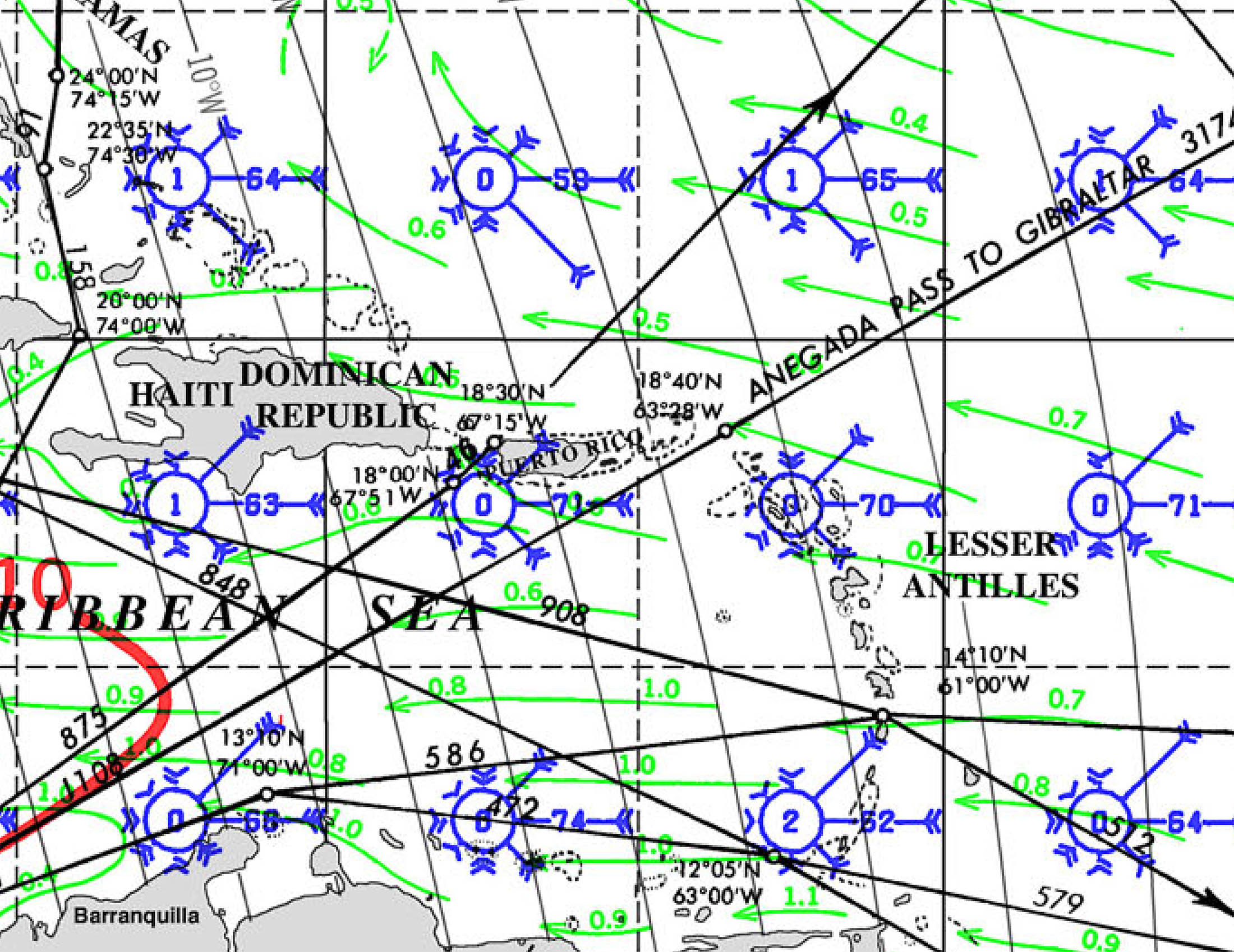
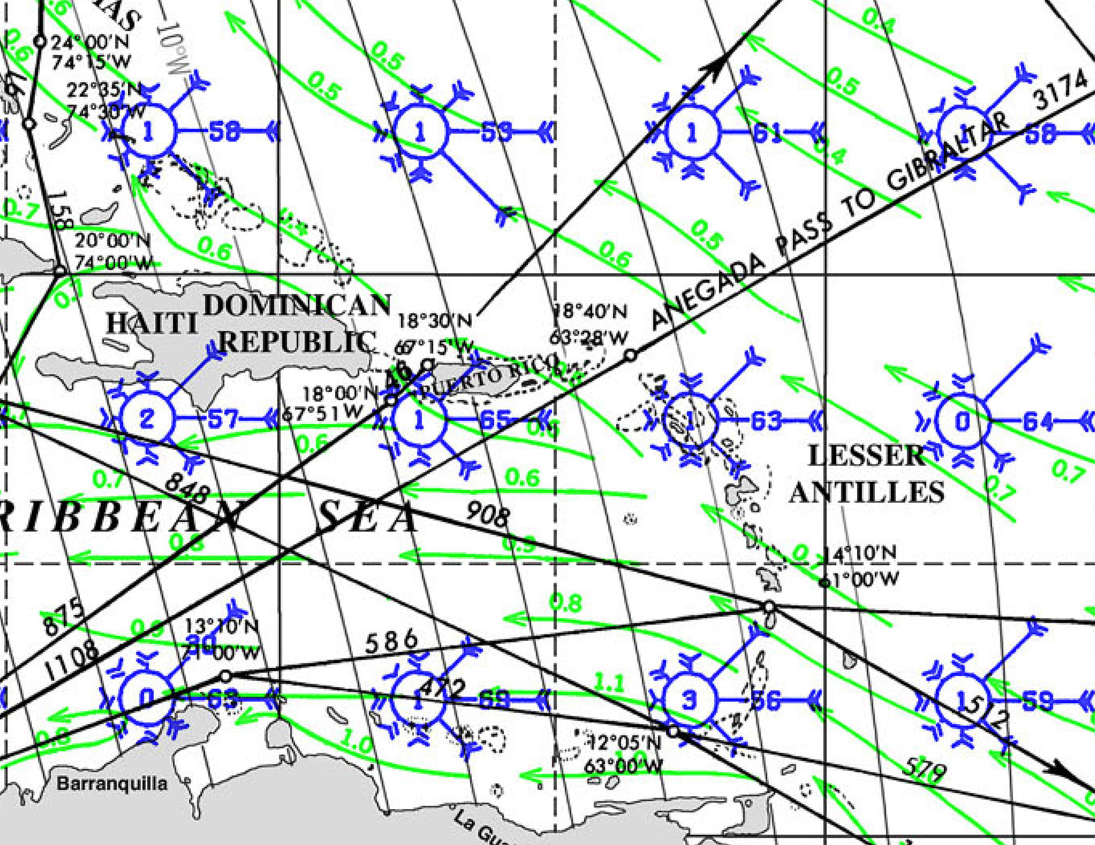
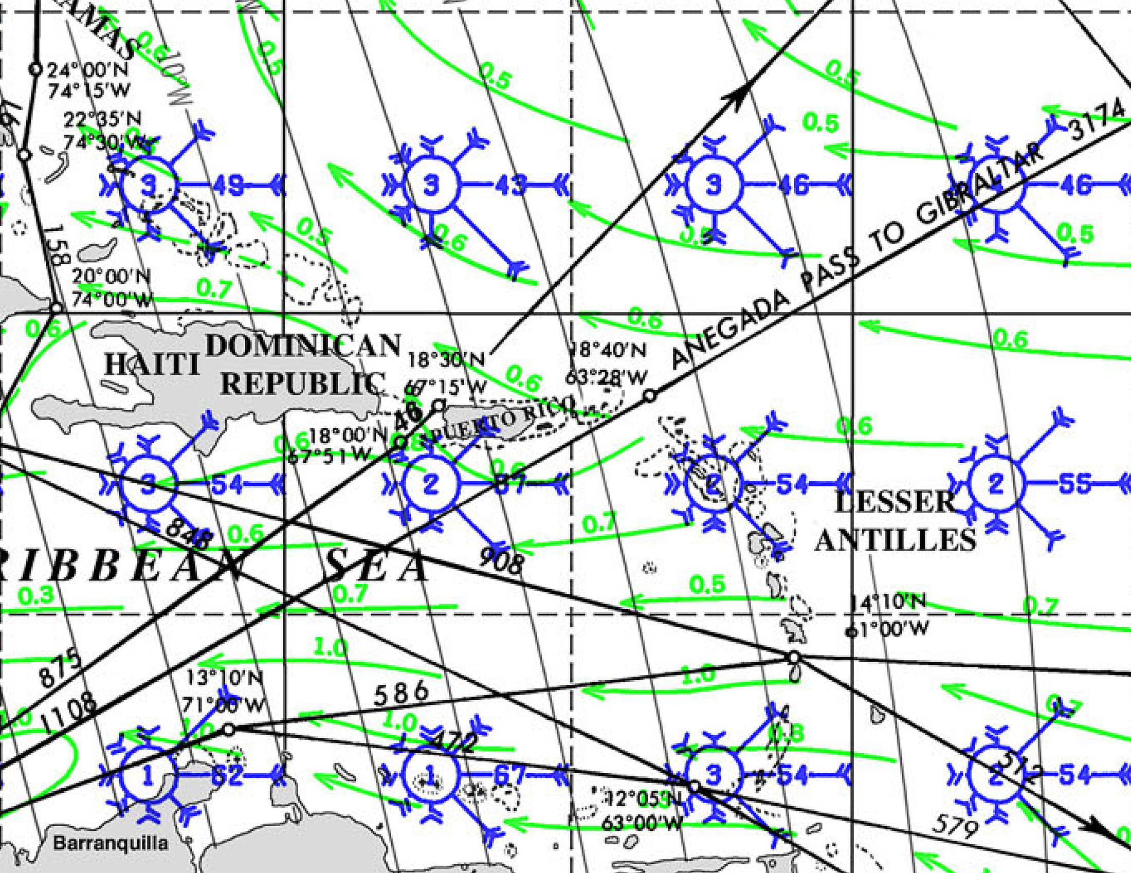
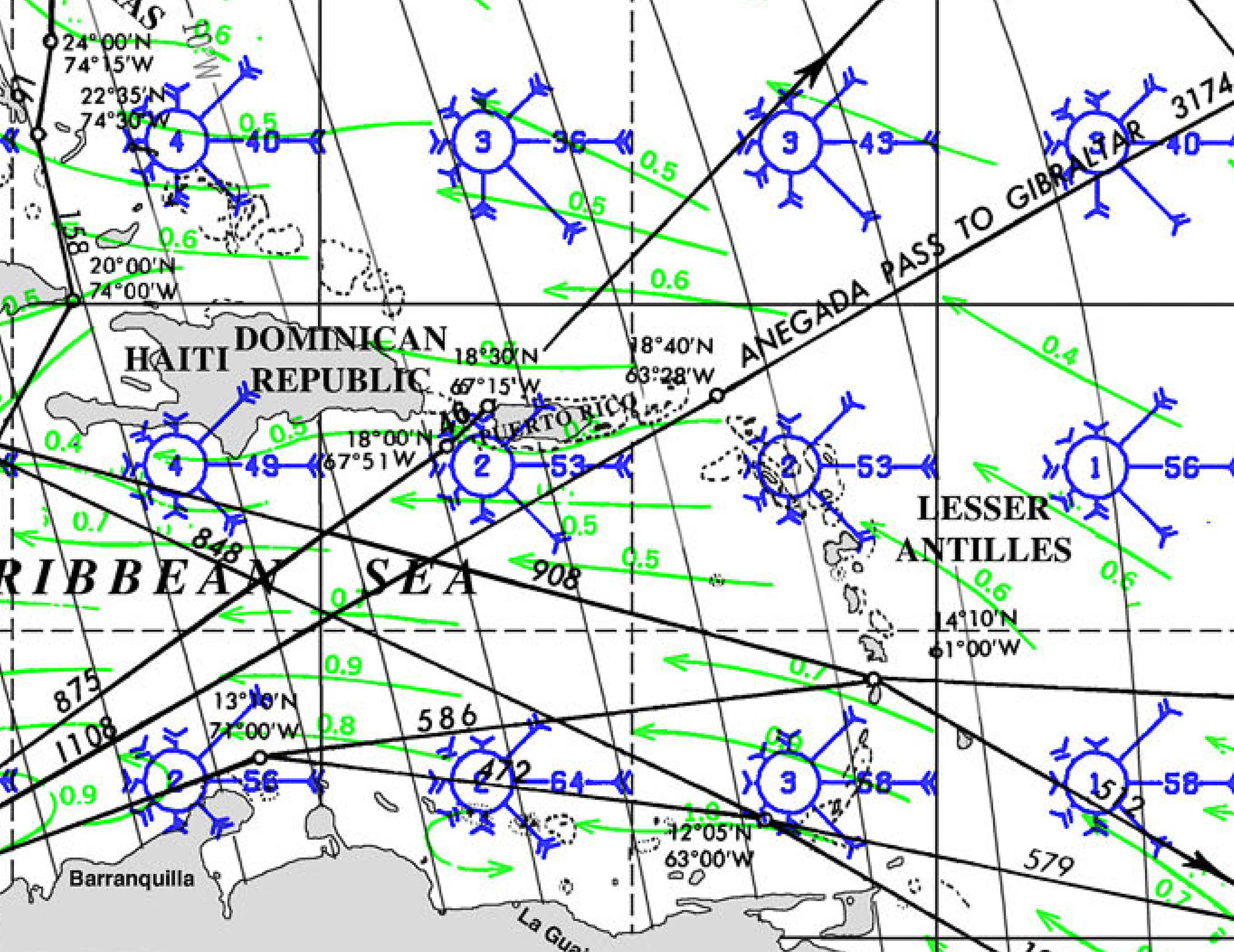
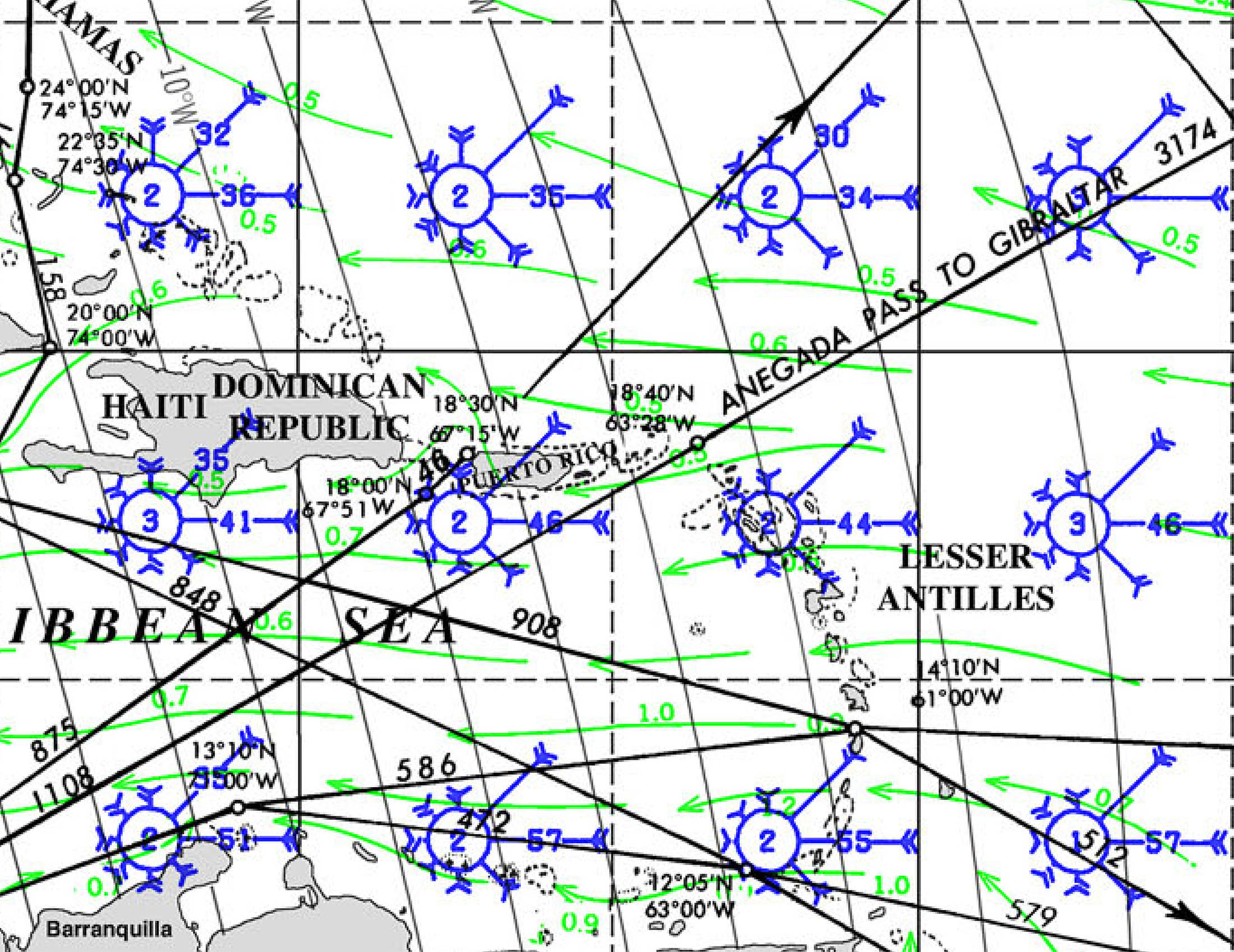
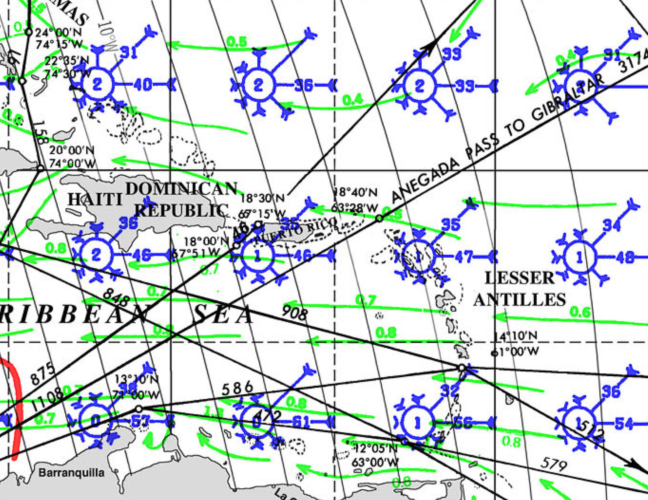
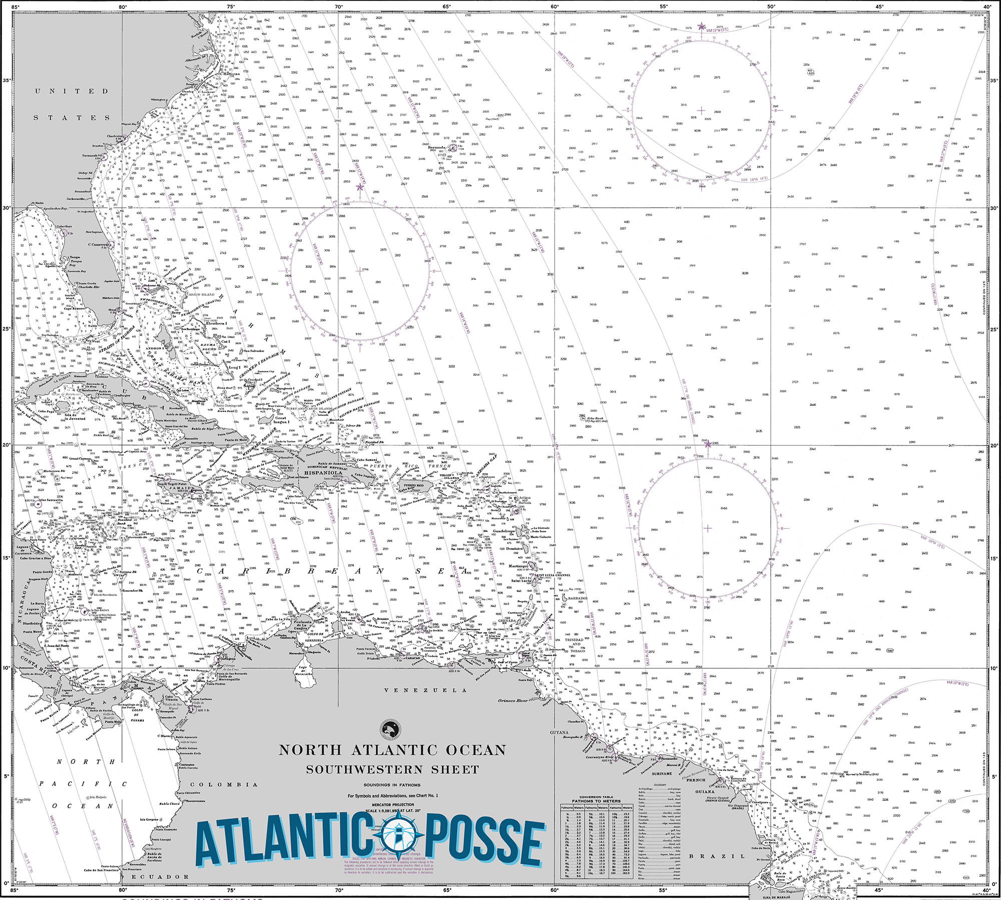
PUERTO RICO Pilot Charts provide historic points and aggregated information of wind flows, air and ocean temperatures, wave heights, rain, barometric weight, and climate conditions at various seasons. This data was acquired from oceanographic and meteorologic perceptions over hundreds of years starting in the late eighteenth century. These diagrams are planned to help mariners choose routes around and approaching Cuba with respect to the normal climate and sea conditions using prevailing seasonal wind information.
PORTS OF ENTRY PUERTO RICO
| Port Name | Location Address | |
|---|---|---|
| Aguadilla, Puerto Rico – 4901 |
Rafael Hernandez Airport
Hanger 405 Bromon Drive
Aguadilla, PR 00604
|
|
| Fajardo, Puerto Rico – 4904 |
U.S. Customhouse
500 Union Street
Puerto Real, PR 00740
|
|
| Luis Munoz Marin International Airport, Puerto Rico – 4913 |
Ave. Baldorioty de Castro
Isla Verde, PR 00937
|
|
| Mayaguez, Puerto Rico – 4907 |
31 Gonzalez Clemente Ave.
Mayaguez, PR 00680
|
|
| Ponce, Puerto Rico – 4908 |
63 Calle Bonaire
Ponce, PR 00716
|
|
| San Juan, PR (Area Port), Puerto Rico – 4909 |
City View Plaza-Suite 3000
#48 Rd. 165 Km. 1.2
Guaynabo, PR 00968-8000
|
Clearing into Puerto Rico with a private yacht involves both Puerto Rican and U.S. customs and immigration requirements. Here is a comprehensive guide on the necessary documents, procedures, and apps needed for clearing into Puerto Rico.
Required Documents
For the Vessel
- Vessel Registration or Documentation: Proof of ownership and registration of the yacht.
- Crew List: Names, nationalities, and passport numbers of all crew members.
- Passenger List: Names, nationalities, and passport numbers of all passengers.
- Customs Declaration Form: Declaration of goods on board, including alcohol, tobacco, and other dutiable items.
- Clearance from Last Port: Clearance documents from the last port of call before entering Puerto Rico.
For the Crew and Passengers
- Passports: Valid passports for all crew members and passengers.
- Visas: Depending on nationality, visas may be required for entry into the U.S. and Puerto Rico.
Customs and Border Protection (CBP) Requirements
Reporting Arrival
- Advance Notice of Arrival: Notify CBP at least 24 hours before arrival. This can be done through the Small Vessel Reporting System (SVRS) or by calling the local CBP office.
- Customs Decal: Obtain an annual CBP user fee decal if the yacht is 30 feet or longer. This can be done through the DTOPS system.
- Arrival Inspection: Upon arrival, report to the nearest CBP office for an inspection. This may include a physical inspection of the vessel and documentation review.
Apps and Online Systems
- ROAM App: The CBP ROAM (Reporting Offsite Arrival – Mobile) app allows private boaters to report their arrival and make customs declarations via a mobile device. The app can be downloaded from the Apple App Store or Google Play Store. Using ROAM can expedite the clearing process.
- Small Vessel Reporting System (SVRS): Pre-register your vessel and crew with the SVRS to streamline the reporting process. You can access the SVRS portal through the CBP website.
- eAPIS: The Electronic Advance Passenger Information System (eAPIS) is used for reporting crew and passenger information to CBP. This is especially important if your arrival involves entry from outside the U.S. It can be accessed at the eAPIS website.
Entry Procedures
- Pre-Arrival Notification: Notify CBP at least 24 hours before arrival using the ROAM app or by contacting the local CBP office.
- Docking at a Designated Port of Entry: Ensure that you dock at a designated Port of Entry in Puerto Rico. Major ports include San Juan, Fajardo, and Ponce.
- Customs Inspection: Upon arrival, expect a customs inspection. Ensure all crew and passengers have their passports and necessary visas ready.
- Complete Customs Declaration: Use the ROAM app to complete the customs declaration process if not already done.
Health and Safety Regulations
- Health Declaration Forms: Due to COVID-19, health declaration forms or proof of vaccination/negative test results may be required. Check current health guidelines before departure.
Contacts for Major Ports of Entry
- San Juan CBP Office
- Phone: +1 787-729-6850
- Address: 1 La Puntilla Street, San Juan, PR 00901
- Fajardo CBP Office
- Phone: +1 787-863-0950
- Address: 487 Carr 987, Sardinera Fishing Village, Fajardo, PR 00738
- Ponce CBP Office
- Phone: +1 787-842-3600
- Address: Mercedita Airport Road 10, Ponce, PR 00731
DOCUMENTS
Clearing into Puerto Rico with a private yacht involves both Puerto Rican and U.S. customs and immigration requirements. Here is a comprehensive guide on the necessary documents, procedures, and apps needed for clearing into Puerto Rico.
Required Documents
For the Vessel
- Vessel Registration or Documentation: Proof of ownership and registration of the yacht.
- Crew List: Names, nationalities, and passport numbers of all crew members.
- Passenger List: Names, nationalities, and passport numbers of all passengers.
- Customs Declaration Form: Declaration of goods on board, including alcohol, tobacco, and other dutiable items.
- Clearance from Last Port: Clearance documents from the last port of call before entering Puerto Rico.
For the Crew and Passengers
- Passports: Valid passports for all crew members and passengers.
- Visas: Depending on nationality, visas may be required for entry into the U.S. and Puerto Rico.
- COVID-19 Documentation: Proof of vaccination or negative test results, if required by current health regulations.
Customs and Border Protection (CBP) Requirements
Reporting Arrival
- Advance Notice of Arrival: Notify CBP at least 24 hours before arrival. This can be done through the Small Vessel Reporting System (SVRS) or by calling the local CBP office.
- Customs Decal: Obtain an annual CBP user fee decal if the yacht is 30 feet or longer. This can be done through the DTOPS system.
- Arrival Inspection: Upon arrival, report to the nearest CBP office for an inspection. This may include a physical inspection of the vessel and documentation review.
Apps and Online Systems
- ROAM App: The CBP ROAM (Reporting Offsite Arrival – Mobile) app allows private boaters to report their arrival and make customs declarations via a mobile device. The app can be downloaded from the Apple App Store or Google Play Store. Using ROAM can expedite the clearing process.
- Small Vessel Reporting System (SVRS): Pre-register your vessel and crew with the SVRS to streamline the reporting process. You can access the SVRS portal through the CBP website.
- eAPIS: The Electronic Advance Passenger Information System (eAPIS) is used for reporting crew and passenger information to CBP. This is especially important if your arrival involves entry from outside the U.S. It can be accessed at the eAPIS website.
Entry Procedures
- Pre-Arrival Notification: Notify CBP at least 24 hours before arrival using the ROAM app or by contacting the local CBP office.
- Docking at a Designated Port of Entry: Ensure that you dock at a designated Port of Entry in Puerto Rico. Major ports include San Juan, Fajardo, and Ponce.
- Customs Inspection: Upon arrival, expect a customs inspection. Ensure all crew and passengers have their passports and necessary visas ready.
- Complete Customs Declaration: Use the ROAM app to complete the customs declaration process if not already done.
Health and Safety Regulations
- Health Declaration Forms: Due to COVID-19, health declaration forms or proof of vaccination/negative test results may be required. Check current health guidelines before departure.
Contacts for Major Ports of Entry
- San Juan CBP Office
- Phone: +1 787-729-6850
- Address: 1 La Puntilla Street, San Juan, PR 00901
- Fajardo CBP Office
- Phone: +1 787-863-0950
- Address: 487 Carr 987, Sardinera Fishing Village, Fajardo, PR 00738
- Ponce CBP Office
- Phone: +1 787-842-3600
- Address: Mercedita Airport Road 10, Ponce, PR 00731
MUST SEE
1. El Yunque National Forest
Latitude: 18°17.73’N
Longitude: 65°47.74’W
Description: El Yunque National Forest is the only tropical rainforest in the U.S. National Forest System. Spanning approximately 29,000 acres, it is renowned for its lush vegetation, diverse wildlife, and stunning scenery. Visitors can explore numerous trails leading to spectacular waterfalls, such as La Mina Falls and La Coca Falls. El Yunque’s unique ecosystem supports hundreds of plant species, many of which are endemic to Puerto Rico. Birdwatchers will delight in the chance to see the Puerto Rican parrot, an endangered species. The forest’s visitor center offers educational exhibits and information about the area’s natural history. Whether you’re an avid hiker or simply looking to enjoy nature’s beauty, El Yunque provides a serene escape from the hustle and bustle of city life.
2. Old San Juan
Latitude: 18°27.93’N
Longitude: 66°06.34’W
Description: Old San Juan is the historic colonial district of San Juan, Puerto Rico’s capital city. Founded in 1521, it is one of the oldest settlements in the Americas. The area is famous for its well-preserved Spanish colonial architecture, vibrant streets, and rich history. Visitors can wander through cobblestone streets lined with colorful buildings, visit the impressive San Felipe del Morro and San Cristóbal forts, and explore historic churches like the San Juan Cathedral. The district also offers numerous museums, galleries, and shops, making it a cultural hub. Cafes and restaurants serve a variety of local and international cuisines, allowing visitors to enjoy the island’s culinary delights. Old San Juan’s waterfront offers stunning views of the Atlantic Ocean, and the Paseo de la Princesa promenade provides a scenic place for a leisurely stroll. With its blend of history, culture, and beauty, Old San Juan is a must-visit destination.
3. Culebra Island
Latitude: 18°19.00’N
Longitude: 65°18.00’W
Description: Culebra Island, located approximately 17 miles east of the Puerto Rican mainland, is a tropical paradise known for its pristine beaches and clear turquoise waters. Flamenco Beach, often ranked among the world’s best beaches, is a crescent-shaped bay with soft white sand and calm, shallow waters ideal for swimming and snorkeling. The island is also home to the Culebra National Wildlife Refuge, which covers more than 20% of the island and includes several smaller surrounding islands. This refuge protects critical habitats for seabirds, turtles, and other wildlife. Visitors can explore the island’s vibrant coral reefs, perfect for diving and snorkeling enthusiasts. Culebra’s laid-back atmosphere, limited development, and natural beauty make it an ideal destination for those seeking a tranquil escape. The island offers various accommodations, from charming guesthouses to beachfront villas, ensuring a comfortable stay.
4. Vieques Island
Latitude: 18°08.27’N
Longitude: 65°26.41’W
Description: Vieques Island, located 8 miles east of Puerto Rico, is renowned for its unspoiled beauty and bioluminescent bays. The island is home to Mosquito Bay, the brightest bioluminescent bay in the world. At night, the waters of Mosquito Bay glow with a magical blue-green light produced by microscopic organisms called dinoflagellates. This natural phenomenon is best experienced on a moonless night, either by kayak or electric boat. Vieques also boasts stunning beaches, such as Playa Caracas and Playa Negra, offering soft sands and clear waters perfect for swimming and relaxation. The island’s history as a former U.S. Navy training ground has left a legacy of protected lands, now part of the Vieques National Wildlife Refuge. Visitors can explore trails, observe wildlife, and discover remnants of the island’s past. Vieques’ blend of natural wonders and historical intrigue make it a captivating destination.
5. Ponce
Latitude: 18°00.67’N
Longitude: 66°36.85’W
Description: Ponce, known as “La Perla del Sur” (The Pearl of the South), is Puerto Rico’s second-largest city and a cultural treasure. Founded in 1692, Ponce boasts a rich architectural heritage, with beautifully preserved colonial buildings and neoclassical structures. The city’s central square, Plaza Las Delicias, is a vibrant hub surrounded by landmarks such as the Ponce Cathedral and the iconic Parque de Bombas, a historic firehouse turned museum. Ponce is also home to several notable museums, including the Museo de Arte de Ponce, which houses a significant collection of European and Puerto Rican art. Visitors can stroll through the picturesque streets of the historic district, explore local shops and cafes, and enjoy the city’s lively cultural scene. Ponce’s coastal location offers easy access to beautiful beaches and the scenic Ponce Boardwalk. The city’s unique blend of history, art, and coastal charm make it a must-visit destination.
6. Río Camuy Cave Park
Latitude: 18°20.10’N
Longitude: 66°50.30’W
Description: Río Camuy Cave Park, located in northwestern Puerto Rico, is a natural wonder featuring one of the largest cave systems in the Western Hemisphere. The park spans approximately 268 acres and includes an extensive network of limestone caves, sinkholes, and underground rivers. The main attraction is the Cueva Clara, a massive cavern adorned with impressive stalactites and stalagmites. Visitors can take guided tours through the cave, learning about its geological formations and the history of its discovery. The park also features the stunning Tres Pueblos Sinkhole, offering breathtaking views and a chance to observe the lush vegetation that thrives in this unique environment. Río Camuy Cave Park provides an unforgettable experience for nature enthusiasts, adventurers, and those curious about the underground world. The park’s visitor center offers educational exhibits and amenities to ensure a comfortable and informative visit.
7. La Parguera
Latitude: 17°58.40’N
Longitude: 67°02.72’W
Description: La Parguera, located in the southwestern part of Puerto Rico, is a charming fishing village known for its vibrant marine life and beautiful coastal scenery. The area is famous for its bioluminescent bay, where visitors can witness the mesmerizing glow of microscopic organisms lighting up the water at night. Boat tours and kayaking excursions are popular ways to experience this natural wonder. La Parguera also offers excellent opportunities for snorkeling and diving, with nearby coral reefs teeming with colorful fish and other marine creatures. The village itself has a laid-back atmosphere, with waterfront restaurants serving fresh seafood, local shops, and friendly locals. Nearby, the La Parguera Natural Reserve protects mangroves, salt marshes, and seagrass beds, providing a haven for birdwatchers and nature enthusiasts. With its unique natural attractions and relaxed vibe, La Parguera is a must-visit destination for anyone exploring Puerto Rico.
8. Cabo Rojo Lighthouse (Faro Los Morrillos)
Latitude: 17°56.18’N
Longitude: 67°11.84’W
Description: The Cabo Rojo Lighthouse, also known as Faro Los Morrillos, is an iconic landmark situated on the southwestern tip of Puerto Rico. Perched atop limestone cliffs, the lighthouse offers breathtaking panoramic views of the Caribbean Sea and the surrounding landscape. Built in 1882, the historic structure has been carefully restored and now serves as a museum and a popular tourist attraction. Visitors can explore the lighthouse, learn about its history and significance, and enjoy the stunning vistas from the observation deck. The area around the lighthouse is part of the Cabo Rojo National Wildlife Refuge, which protects diverse habitats, including salt flats, lagoons, and mangroves. The nearby Playa Sucia, a pristine beach with turquoise waters and soft white sand, is perfect for swimming and sunbathing. The combination of natural beauty and historical interest makes the Cabo Rojo Lighthouse a must-see destination.
9. Gilligan’s Island (Cayo Aurora)
Latitude: 17°57.10’N
Longitude: 66°55.58’W
Description: Gilligan’s Island, officially known as Cayo Aurora, is a small mangrove island off the southwestern coast of Puerto Rico. Accessible by boat from the town of Guánica, the island is a popular day-trip destination known for its crystal-clear waters and serene natural environment. The shallow, calm waters surrounding the island are ideal for snorkeling and swimming, allowing visitors to explore the vibrant marine life and underwater ecosystems. The island features picnic areas, shaded spots, and sandy beaches, making it a perfect place for a relaxing day in the sun. Kayaking and paddleboarding are also popular activities, offering a unique way to navigate the island’s channels and mangrove forests. With its tranquil atmosphere and natural beauty, Gilligan’s Island is a hidden gem that offers a peaceful escape from the hustle and bustle of everyday life.
10. Toro Negro State Forest
Latitude: 18°11.72’N
Longitude: 66°34.48’W
Description: Toro Negro State Forest, located in the central mountainous region of Puerto Rico, is a lush and diverse natural reserve offering a variety of outdoor activities and scenic beauty. The forest covers approximately 7,000 acres and features rugged terrain, dense vegetation, and numerous rivers and waterfalls. Hiking enthusiasts
11. Arecibo Observatory
Latitude: 18°20.65’N
Longitude: 66°45.17’W
Description: The Arecibo Observatory, located near the town of Arecibo in northern Puerto Rico, was once home to the world’s largest radio telescope. Completed in 1963, the observatory played a crucial role in astronomical research, contributing to significant discoveries in radio astronomy, atmospheric science, and planetary radar studies. Although the main telescope collapsed in 2020, the site remains a symbol of scientific achievement and continues to offer educational programs and tours. Visitors can learn about the observatory’s history, its scientific contributions, and the ongoing efforts to preserve its legacy. The surrounding area, part of the Arecibo Observatory National Astronomy and Ionosphere Center, features lush karst landscapes and offers opportunities for hiking and exploring the unique geological formations. The Arecibo Observatory remains an important landmark, celebrating Puerto Rico’s contributions to science and technology.
12. Las Cabezas de San Juan Nature Reserve
Latitude: 18°22.45’N
Longitude: 65°37.22’W
Description: Las Cabezas de San Juan Nature Reserve, located on the northeastern tip of Puerto Rico in Fajardo, is a protected area known for its diverse ecosystems and stunning coastal scenery. The reserve encompasses mangroves, coral reefs, lagoons, dry forests, and sandy beaches, providing a habitat for a wide variety of plant and animal species. One of the reserve’s most notable features is the historic Fajardo Lighthouse, built in 1882, which offers panoramic views of the Atlantic Ocean and the surrounding landscape. Guided tours are available, allowing visitors to explore the reserve’s natural beauty and learn about its ecological significance. The bioluminescent lagoon within the reserve is another highlight, where visitors can witness the enchanting glow of microscopic organisms lighting up the water at night. Las Cabezas de San Juan is a haven for nature enthusiasts, offering a unique opportunity to experience Puerto Rico’s rich biodiversity.
13. Cueva Ventana
Latitude: 18°22.18’N
Longitude: 66°45.82’W
Description: Cueva Ventana, or “Window Cave,” is a stunning natural attraction located in Arecibo, Puerto Rico. This impressive cave is situated atop a limestone cliff and offers breathtaking views of the Río Grande de Arecibo valley below. To reach the cave, visitors must embark on a guided hike through lush forest, learning about the local flora and fauna along the way. The cave itself is adorned with stalactites and stalagmites, creating a fascinating underground landscape. The highlight of the visit is the large, window-like opening at the end of the cave, which frames the picturesque valley and offers a perfect photo opportunity. Cueva Ventana is not only a geological wonder but also a cultural site, as it contains ancient Taino petroglyphs. The combination of natural beauty, history, and adventure makes Cueva Ventana a must-see destination for visitors to Puerto Rico.
14. Punta Tuna Lighthouse
Latitude: 17°57.90’N
Longitude: 65°52.83’W
Description: Punta Tuna Lighthouse, located in the southeastern town of Maunabo, Puerto Rico, is a historic beacon offering panoramic views of the Caribbean Sea. Built in 1892, the lighthouse stands on a picturesque promontory surrounded by rugged cliffs and pristine beaches. The lighthouse has been restored and is now a museum, providing visitors with insights into its history and significance in maritime navigation. The area around Punta Tuna is also known for its natural beauty, with lush vegetation and coastal trails perfect for hiking and birdwatching. The nearby Playa Maunabo is a serene beach with golden sands and clear waters, ideal for swimming and relaxation. Punta Tuna Lighthouse is a great destination for history enthusiasts, nature lovers, and anyone seeking a peaceful escape by the sea.
15. Caguana Indigenous Ceremonial Park
Latitude: 18°16.52’N
Longitude: 66°48.98’W
Description: Caguana Indigenous Ceremonial Park, located in Utuado, Puerto Rico, is one of the most important archaeological sites in the Caribbean. This ancient Taino ceremonial center dates back to around 1200 AD and offers a unique glimpse into the island’s pre-Columbian history. The park features a series of well-preserved stone structures, including ball courts, plazas, and petroglyphs, which were used for religious and social ceremonies. The on-site museum provides educational exhibits about Taino culture, artifacts, and the significance of the site. Visitors can explore the park’s lush surroundings, walk through the historic grounds, and learn about the Taino people’s way of life. Caguana Indigenous Ceremonial Park is a fascinating destination for history buffs, archaeology enthusiasts, and anyone interested in Puerto Rico’s rich cultural heritage.
16. Flamenco Beach
Latitude: 18°20.34’N
Longitude: 65°18.20’W
Description: Flamenco Beach, located on Culebra Island, is often ranked among the best beaches in the world. This stunning crescent-shaped bay is renowned for its soft white sand, clear turquoise waters, and tranquil atmosphere. The beach is ideal for swimming, snorkeling, and sunbathing, with gentle waves and shallow waters perfect for families. Flamenco Beach is part of the Culebra National Wildlife Refuge, ensuring its pristine condition and natural beauty. The beach is also home to the iconic rusting tanks, remnants from U.S. military exercises, which have become popular photo spots. Visitors can enjoy amenities such as picnic areas, restrooms, and food kiosks offering local snacks and drinks. Flamenco Beach’s breathtaking scenery, relaxed vibe, and excellent facilities make it a must-visit destination for beach lovers and nature enthusiasts.
17. El Morro (Castillo San Felipe del Morro)
Latitude: 18°28.17’N
Longitude: 66°07.13’W
Description: El Morro, officially known as Castillo San Felipe del Morro, is a historic fortress located at the entrance to San Juan Bay in Puerto Rico. Built by the Spanish between the 16th and 18th centuries, El Morro was designed to defend the city of San Juan from seaborne invaders. The fortress features massive stone walls, towering bastions, and strategically placed cannons, offering a glimpse into the island’s colonial past. Visitors can explore the fort’s labyrinthine corridors, ramparts, and dungeons, learning about its history through informative exhibits and guided tours. The fort’s elevated position provides stunning views of the Atlantic Ocean and the city of San Juan. The surrounding grounds, known as El Morro Esplanade, are popular for picnics, kite flying, and leisurely strolls. El Morro’s blend of historical significance and scenic beauty makes it a must-visit landmark in Puerto Rico.
18. San Cristóbal Castle (Castillo de San Cristóbal)
Latitude: 18°28.15’N
Longitude: 66°06.82’W
Description: San Cristóbal Castle, or Castillo de San Cristóbal, is a historic fortification located in Old San Juan, Puerto Rico. Constructed by the Spanish between 1634 and 1790, it is the largest fortress built by the Spanish in the New World. San Cristóbal was designed to protect the city from land-based attacks and features an intricate system of tunnels, moats, and defensive walls. Visitors can explore the fort’s extensive grounds, including the main plaza, barracks, and observation towers. The fort offers panoramic views of San Juan, the Atlantic Ocean, and the surrounding area. Informative exhibits and guided tours provide insights into the fort’s construction, military history, and the daily life of its soldiers. San Cristóbal Castle, along with El Morro, is part of the San Juan National Historic Site, a UNESCO World Heritage Site. The fort’s historical significance and impressive architecture make it a must-see attraction.
19. Paseo de la Princesa
Latitude: 18°27.87’N
Longitude: 66°07.01’W
Description: Paseo de la Princesa is a picturesque promenade located in Old San Juan, Puerto Rico. Stretching along the city’s historic walls, the promenade offers stunning views of San Juan Bay and the Atlantic Ocean. The walkway is lined with lush gardens, decorative fountains, and historic statues, creating a serene and scenic atmosphere. One of the promenade’s main attractions is the Raíces Fountain, a beautiful bronze sculpture symbolizing Puerto Rico’s cultural heritage. Visitors can stroll along the promenade, relax on benches, and enjoy the cool ocean breeze. Paseo de la Princesa is also home to La Princesa, a historic building that once served as a prison and now houses the Puerto Rico Tourism Company. The promenade frequently hosts cultural events, live music, and artisan markets, making it a vibrant gathering place for locals and tourists alike. With its blend of history, culture, and natural beauty, Paseo de la Princesa is a must-visit destination in San Juan.
20. Cañón San Cristóbal
Latitude: 18°12.73’N
Longitude: 66°26.47’W
Description: Cañón San Cristóbal, located in the central mountainous region of Puerto Rico, is a spectacular natural canyon offering stunning scenery and outdoor adventure. The canyon, carved by the Río Usabón, features towering cliffs, lush vegetation, and cascading waterfalls. Visitors can explore the area
1. Puerto Del Rey Marina
Location: Fajardo
Coordinates: 18°17.4’N, 65°38.0’W
Services: Full-service marina, boat repairs, fuel, dry stack storage, provisioning, haul-out services.
Contact Info:
- Phone: +1 787-860-1000
- Email: info@puertodelrey.com
- Website: puertodelrey.com
2. Sunbay Marina
Location: Fajardo
Coordinates: 18°19.7’N, 65°38.1’W
Services: Repairs, fuel, dry dock, provisioning, 24-hour security, electrical services, and boatyard.
Contact Info:
- Phone: +1 787-863-0313
- Email: info@sunbaymarina.com
- Website: sunbaymarina.com
3. Villa Marina Yacht Harbour
Location: Fajardo
Coordinates: 18°20.0’N, 65°37.5’W
Services: Boat storage, repairs, fueling, marine store, and yacht maintenance services.
Contact Info:
- Phone: +1 787-863-4990
- Email: info@villamarinayachtharbour.com
- Website: villamarinayachtharbour.com
4. Puerto Chico Marina
Location: Fajardo
Coordinates: 18°19.9’N, 65°38.0’W
Services: Fuel dock, repair services, provisioning, ship store, dry dock, and yacht maintenance.
Contact Info:
- Phone: +1 787-863-0613
- Email: info@puertochicomarina.com
- Website: puertochicomarina.com
5. Ponce Yacht & Fishing Club
Location: Ponce
Coordinates: 17°57.5’N, 66°37.3’W
Services: Boat repair services, fuel dock, provisioning, and marine store.
Contact Info:
- Phone: +1 787-842-9003
- Email: info@ponceyachtclub.com
- Website: ponceyachtclub.com
6. Marina Pescaderia
Location: Cabo Rojo
Coordinates: 18°04.8’N, 67°11.3’W
Services: Boat repairs, fuel, provisioning, maintenance, and marine store.
Contact Info:
- Phone: +1 787-717-3638
- Email: info@marinapescaderia.com
- Website: marinapescaderia.com
7. Puerto Real Marina
Location: Cabo Rojo
Coordinates: 18°04.5’N, 67°11.1’W
Services: Boat maintenance, fuel, repairs, and haul-out services.
Contact Info:
- Phone: +1 787-851-2110
- Email: info@puertorealmarina.com
- Website: puertorealmarina.com
8. Seaborne Marina
Location: Isla Grande, San Juan
Coordinates: 18°27.8’N, 66°05.7’W
Services: Fuel, repairs, haul-out services, provisioning, and 24-hour security.
Contact Info:
- Phone: +1 787-725-2517
- Email: info@seabornemarina.com
- Website: seabornemarina.com
9. Palmas del Mar Yacht Club
Location: Humacao
Coordinates: 18°04.3’N, 65°47.9’W
Services: Full-service marina with fueling, repairs, provisioning, and access to resort amenities.
Contact Info:
- Phone: +1 787-285-0155
- Email: info@palmasdelmaryachtclub.com
- Website: palmasdelmaryachtclub.com
10. Marina de Salinas
Location: Salinas
Coordinates: 17°57.0’N, 66°17.4’W
Services: Fuel, repairs, boat maintenance, and provisioning services.
Contact Info:
- Phone: +1 787-824-3185
- Email: info@marinadesalinas.com
- Website: marinadesalinas.com
EMERGENCY
Those in need of emergency assistance are to either call the police at +1 787 3432020
or the State Agency for Emergency and Disaster Management at +1 787 7240124, which are both operational 24-hours a day
SAR ( SEARCH AND RESCUE )
JRSC San Juan (USCG) (COSPAS-SARSAT SPOC)
Latitude, Longitude:
(18.39999962,-66.08167267)
Telephone:
+1 787 729 6770
Alternate phone: 289-2041 / 289-2042
Email: SSJCC@USCG.MIL
Fax +1 787 729 6706