
CHARTS NORTH UP
AU - Török, Zsolt
PY - 2020/10/08
SP - 1
EP - 2
T1 - North in the head: spatial reference frame and map orientation
VL - 2
DO - 10.5194/ica-abs-2-6-2020
JO - Abstracts of the ICA
ER -
MANGROVES
Mangroves: Guardians of the Coastline and Stewards of the Sea
I. Introduction: Where Land and Sea Embrace
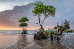
Mangroves are nature’s answer to the challenging meeting point between land and sea. Found in tropical and subtropical coastlines across the globe, these unique ecosystems blur the lines between saltwater and soil. With gnarled roots rising from brackish waters, they form a labyrinth of life and shelter. For sailors, mangroves are more than just scenery—they’re anchorages in storms, quiet havens for rest, and signs of a healthy coast.
Mangroves protect coastlines, nurture marine life, store massive amounts of carbon, and stand as some of the most productive ecosystems on Earth. They are critical for biodiversity, vital for climate resilience, and irreplaceable for coastal communities.
II. What Are Mangroves?
Definition and Composition
Mangroves are a group of salt-tolerant trees and shrubs adapted to grow in intertidal zones—where freshwater rivers meet salty seas. They are not a taxonomic group, but rather a functional one: more than 80 species of trees and shrubs belong to about 20 plant families globally, all with adaptations for living in saline, anaerobic (low-oxygen) soils.
Global Distribution
Mangroves are found in over 120 tropical and subtropical countries. The five countries with the largest mangrove areas are:
• Indonesia
• Brazil
• Nigeria
• Australia
• Mexico
Prominent mangrove forests include the Sundarbans in India and Bangladesh, the Everglades in Florida, the mangals of the Caribbean and Central America, and the vast coastal zones of Southeast Asia.
III. Ecological Importance
1. Biodiversity Hotspots
Mangroves support a rich web of life. The submerged root systems provide nurseries for fish, crustaceans, mollusks, and countless invertebrates. Many commercial fish species—including snapper, grouper, and barramundi—rely on mangroves for part of their life cycle. Mudskippers, fiddler crabs, and shrimp colonies thrive in the silt and roots. Above the waterline, monkeys, snakes, bats, and an impressive array of bird species find refuge and nesting ground.
2. Natural Barriers
Mangroves serve as frontline defenders against erosion, storm surges, and tsunamis. Their dense roots trap sediments and buffer the energy of incoming waves. After the 2004 Indian Ocean tsunami, areas with intact mangroves fared significantly better than those where mangroves had been removed.
3. Carbon Sequestration
Mangrove forests are among the most efficient carbon sinks on the planet. They store carbon both above ground (in biomass) and, more importantly, below ground in deep layers of organic-rich peat. A hectare of mangrove can store up to four times more carbon than a tropical rainforest.
4. Water Filtration
The roots filter pollutants and sediments from water, improving water quality offshore. This has a positive effect on coral reefs and seagrass beds, which benefit from reduced sedimentation and nutrient runoff.
IV. Adaptations to a Harsh Environment
Mangroves thrive in conditions hostile to most plants. Their success stems from ingenious adaptations:
A. Salt Management
Mangroves have several salt-tolerance strategies:
• Salt-excreting leaves (e.g., black mangroves)
• Salt-filtering roots (e.g., red mangroves)
• Salt storage in sacrificial leaves (e.g., grey mangroves)
B. Root Structures
Mangroves feature extraordinary root systems adapted to waterlogged and unstable soils:
• Prop roots of red mangroves provide stability and oxygen intake.
• Pneumatophores of black mangroves stick up like snorkels from the mud, allowing gas exchange in anaerobic soils.
• Buttress roots and plank roots stabilize larger trees in soft substrates.
C. Vivipary
Mangrove seeds germinate while still attached to the parent tree—a process known as vivipary. The resulting propagules (elongated seedling structures) drop into the water and drift until they lodge in the sediment and root.
V. Mangroves and Maritime Culture
For generations, sailors, fishers, and coastal peoples have relied on mangroves for everything from shelter to medicine. Mangrove wood is dense and rot-resistant, used for boatbuilding, pilings, and charcoal. The bark of some species has medicinal properties and tannins used in dyeing and leather tanning.
A. Sheltered Anchorages
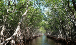
Sailors know that mangrove creeks and estuaries offer calm waters, even in severe weather. The labyrinthine channels form hurricane holes that can save boats and lives. However, anchoring in mangrove ecosystems must be done with care—damaging root systems can have lasting effects on the ecology.
B. Tidal Navigation
Mangrove zones often mark tidal estuaries with shifting sandbanks, making charts quickly outdated. Cruisers navigating these waters must rely on depth sounders, tidal data, and local knowledge. Mangroves also signal the presence of brackish waters and potential freshwater sources upstream.
C. Fisheries and Food Security
Mangroves are key to artisanal fisheries and subsistence economies across the world. The health of nearshore fisheries is directly linked to the integrity of mangrove habitat. Shellfish and crabs found in mangroves are dietary staples in many coastal cultures.
VI. Threats to Mangroves
Despite their importance, mangroves are among the most threatened ecosystems on Earth.
1. Deforestation and Land Use Change
Mangrove forests are often cleared for:
• Shrimp and fish aquaculture
• Agriculture (rice, palm oil, etc.)
• Coastal development (resorts, housing)
• Logging for firewood and charcoal
Between 1980 and 2000, the world lost over 35% of its mangrove cover.
2. Pollution
Industrial runoff, untreated sewage, plastic waste, and oil spills pose enormous threats to mangrove ecosystems. Nutrient overloads can cause algae blooms that smother roots and reduce oxygen availability.
3. Climate Change and Sea-Level Rise
Rising sea levels threaten to drown mangroves unless they can migrate inland. In areas where coastal infrastructure blocks this retreat, mangroves are trapped in a “coastal squeeze” and may die off. Changes in salinity and precipitation also impact growth.
4. Overharvesting
The demand for mangrove wood—especially for charcoal production—can exceed regeneration rates, leading to forest degradation and collapse.
VII. Conservation and Restoration
Efforts to protect and restore mangroves are underway worldwide, with varying degrees of success.
A. Legal Protections
Many countries have designated mangrove zones as protected areas. International agreements like the Ramsar Convention on Wetlands recognize mangroves as globally important.
B. Community-Based Conservation
Locally led initiatives often outperform top-down programs. When coastal communities are empowered and educated about the value of mangroves, conservation tends to succeed. Examples include:
• Mangrove watch programs
• Community replanting initiatives
• Sustainable harvesting regulations
C. Restoration Projects
Restoring mangroves requires more than planting saplings. Successful projects:
• Restore natural tidal flow
• Consider sediment quality
• Use native species appropriate to the site
• Engage local stakeholders
D. Blue Carbon Initiatives
The concept of Blue Carbon—carbon stored in coastal ecosystems—has created new funding opportunities. Mangrove restoration is increasingly recognized as a climate change mitigation strategy.
VIII. Mangroves in the Regions Sailors Know Best
Caribbean
Many Caribbean islands have mangrove fringe zones—often the last refuge for marine life amid coral decline. In Cuba, Jamaica, Belize, and the Bahamas, mangrove health correlates with fishery success.
Central America
From the Mosquito Coast of Nicaragua to the mangrove-rich Gulf of Fonseca (Honduras, El Salvador), these forests are the lifeblood of local economies. Panama’s Darien region is a wilderness of tidal mangals still relatively intact.
South America
Brazil’s coast, particularly in the northeast, features massive mangrove belts. The Amazon estuary has brackish deltas rich in mangrove species that serve as nurseries for Amazonian and Atlantic marine life alike.
Southeast Asia
Mangroves here are heavily pressured. Indonesia and the Philippines have some of the highest deforestation rates, often due to shrimp farms. Yet, large restoration programs are ongoing, backed by international funding.
Australia and the South Pacific
Northern Australia has extensive, relatively pristine mangrove systems. Pacific islands often have limited mangrove belts, but these are vital for storm protection, particularly in low-lying nations like Tuvalu and Kiribati.
IX. What Sailors Can Do
Yacht captains, liveaboards, and cruisers are in a unique position to both witness and protect mangrove ecosystems. Here’s how to contribute:
– Anchor with Care
Avoid anchoring near or within root systems. Use designated moorings when possible. Avoid dragging chains across submerged roots.
– Mind Your Waste
Never dump black water or grey water in mangrove zones. Biodegradable soaps and septic vigilance are essential.
– Report Damage
If you see illegal clearing or pollution, report it to local authorities or NGOs. Photos and coordinates help.
– Support Local Initiatives
Participate in mangrove cleanups or volunteer for educational programs. Purchase from fishers and artisans who use sustainable methods.
– Stay Informed
Learn about the mangrove ecosystems where you sail. Respect closed areas and contribute data to open-source platforms like iNaturalist or Reef Check.
X. Conclusion: Sentinels of the Shoreline
Mangroves are more than trees—they are living bulwarks against climate change, nurseries of the sea, and signs of a thriving coast. For sailors, mangroves offer safety, beauty, and mystery. These tangled forests remind us that resilience is often hidden in the roots, and survival is shaped by adaptation.
In every rising tide, in every creaking root and darting fish, there’s a lesson: respect the edge where ocean meets land, and we just might keep this world afloat a little longer.
If you’d like this version edited into a PDF, turned into a short presentation, or tailored to a specific geography (e.g., “Mangroves of the Bahamas” or “Mangroves of the South Pacific”), just say the word, Captain.
⚓ How to Secure a Yacht to Mangroves for a Hurricane
1. Choose the Right Spot
• Seek a well-protected mangrove-lined creek or hurricane hole with minimal fetch and good holding.
• Avoid areas with strong tidal currents or overhead hazards (power lines, branches).
2. Prepare the Boat
• Remove all sails, canvas, solar panels (if possible), and anything wind-exposed.
• Seal hatches and deck openings; double check bilge pumps are functional.
• Fully charge batteries and shut down unnecessary electrical loads.
3. Set Multiple Anchors
• Drop a primary bow anchor in the center of the creek (ideally with chain + rode).
• If possible, drop a secondary stern or side anchor for directional stability.
4. Run Multiple Mangrove Lines
• Take long, chafe-protected lines (preferably 3/4″ or larger) from strong cleats or winches to mangrove trunks.
• Run lines aft, forward, and abeam to create a web holding the boat in position.
• Tie to thick trunks (not roots) using a round turn and two half hitches, or secure a loop with a bowline around the trunk.
• Use sacrificial lines (old lines, webbing) around the trees to avoid damaging bark.
5. Allow for Tidal Surge
• Ensure there’s vertical play in all lines—tie high enough on trees to stay clear during surge, and allow slack to prevent snapping under rising water.
• Avoid over-tightening lines; lines should be snug but not under extreme tension.
6. Chafe Protection
• Add hoses, towels, fire hose, or anti-chafe gear at every rub point—especially where lines meet chocks, cleats, or trunks.
• Check and replace any UV-brittle lines.
7. Final Checks
• Lock the helm amidships.
• Remove or double lash dinghies, or sink them next to the yacht.
• Add fenders even if you’re not near a dock—rubbing on mangroves or against your own lines can still cause abrasion.
🦟 MOSQUITOES
Mangroves = mosquitoes. Prepare for them.
Preventative Measures:
• Screens on hatches & ports – essential.
• Bug net over bunk – especially if staying aboard.
• Fans – constant air movement deters mosquitoes.
• Repellent – DEET or Picaridin-based sprays work best; citronella and coils help too.
• Insecticide fogger or zapper – helpful in enclosed cabins.
Avoid Dusk and Dawn:
That’s peak biting time. If you’re on deck, wear long sleeves and light clothing.
💧 WATER
During hurricane prep, fresh water is critical.
Best Practices:
• Fill all tanks before entering mangroves.
• Store extra in jerry cans, solar showers, or collapsible containers.
• Solar still or watermaker: Use while you still have good water quality if anchored outside mangroves.
• If staying for days after a storm, rain catchment systems (tarp + jugs) may come in handy.
⛽ FUEL
Secure your energy needs before the storm.
Steps to take:
• Top off all tanks (diesel, gas for dinghy, generator).
• Store extra jerry jugs lashed securely on deck or in lockers.
• Add fuel stabilizer in case the fuel sits for weeks unused.
• Label and date jugs for later rotation.
Post-Storm Note: Fuel docks may be damaged or out of service. Carrying extra is not just wise—it’s vital for mobility and power generation.