

SV GARGOYLE TRANSITS THE CORINTH CANAL IN GREECE
SV GARGOYLE TRANSITS THE CORINTH CANAL IN GREECE

This week SV Gargoyle shares their final stages of their cruising season in Greece with the Ocean Posse:
Gargoyle and her crew are enjoying the last few weeks of the season cruising with family in Greece. This week we've made the transition west from the Saronic Gulf to the Ionian Sea via the incredible Corinth canal. To make things perfect, our daughter and son-in-law have joined us for a ten day stay before we head towards our winter home, Malta's Manoel Island Yacht Marina. Cheers from warm and sunny Greece!


The Corinth Canal connects the Gulf of Corinth in the Ionian Sea with the Saronic Gulf in the Aegean Sea. It cuts through the narrow Isthmus of Corinth and separates the Peloponnese from the Greek mainland, making the peninsula an island. The canal was dug through the Isthmus at sea level and has no locks. It is 6.4 kilometres (4 miles) in length and only 24.6 metres (80.7 feet) wide at sea level

SV GARGOYLE 🇨🇦 Kevin & Carla - Beneteau 50'
ROUTE MEDITERRANEAN SPAIN TO GIBRALTAR
ROUTE
PILOT CHARTS ROUTE SPAIN TO GIBRALTAR
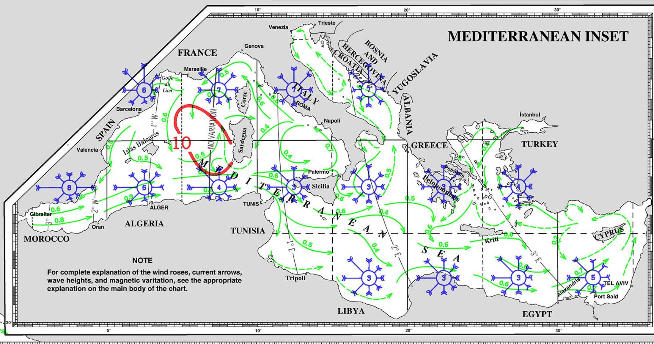
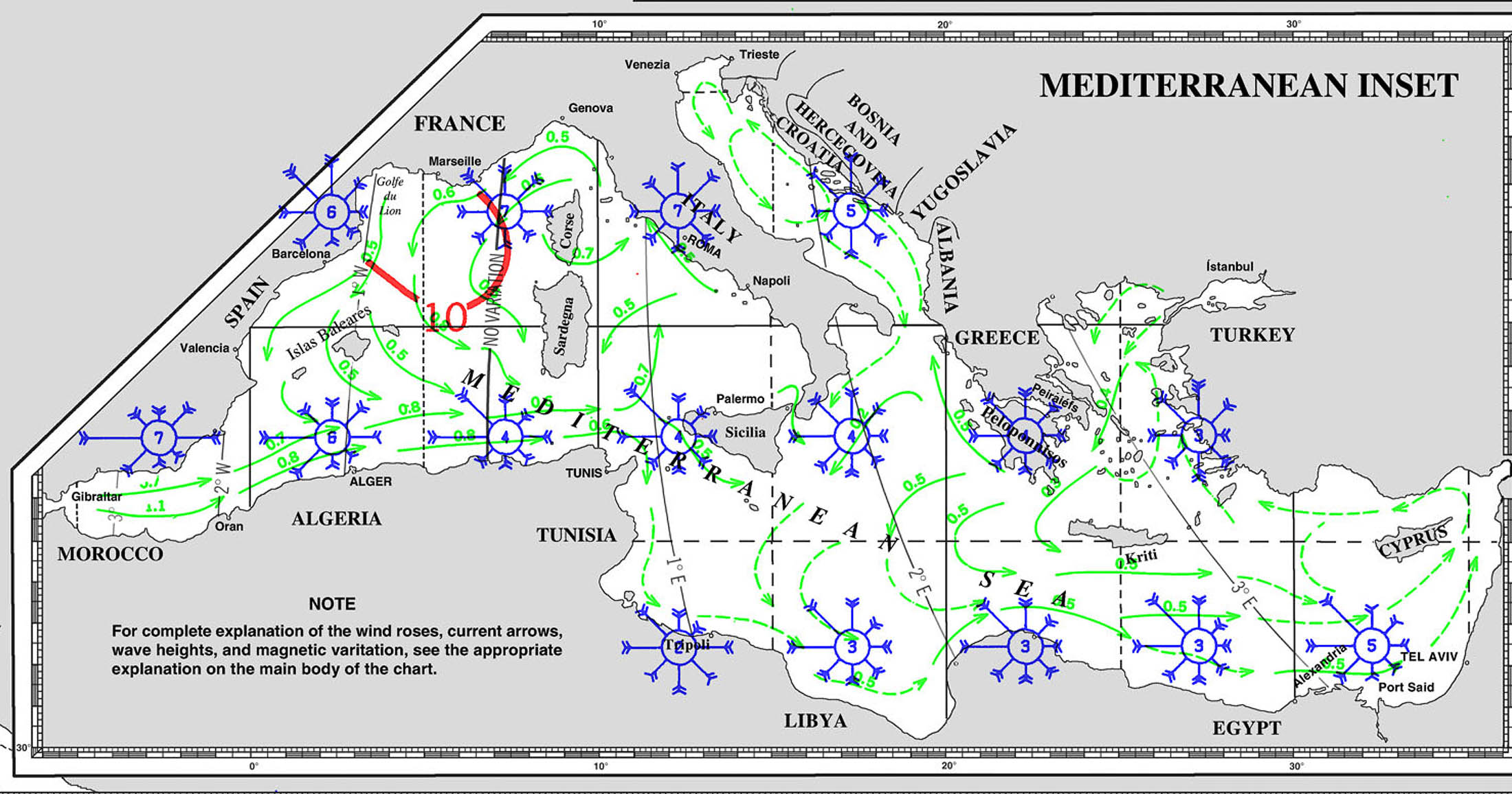
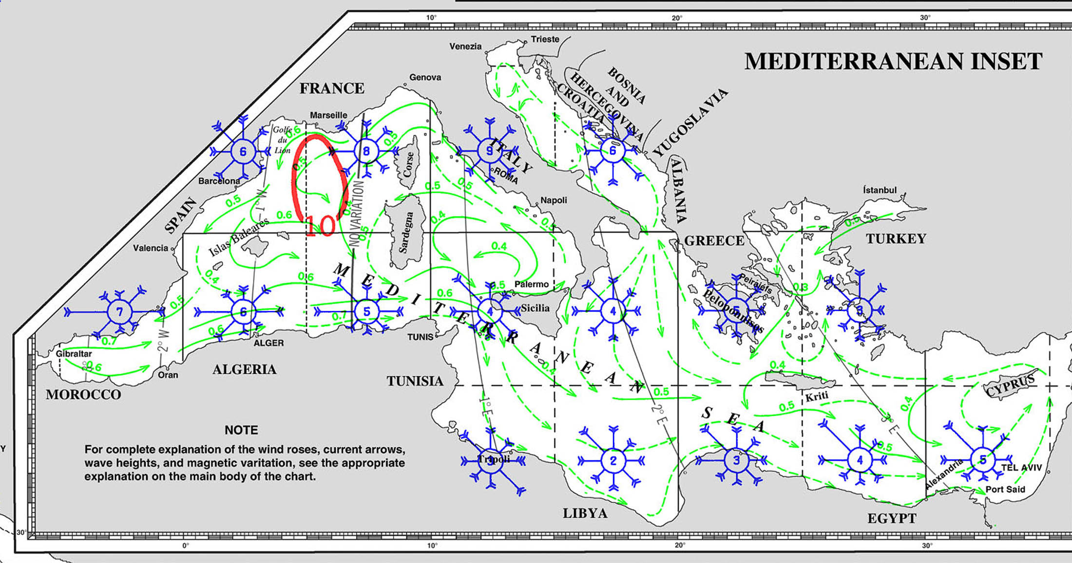
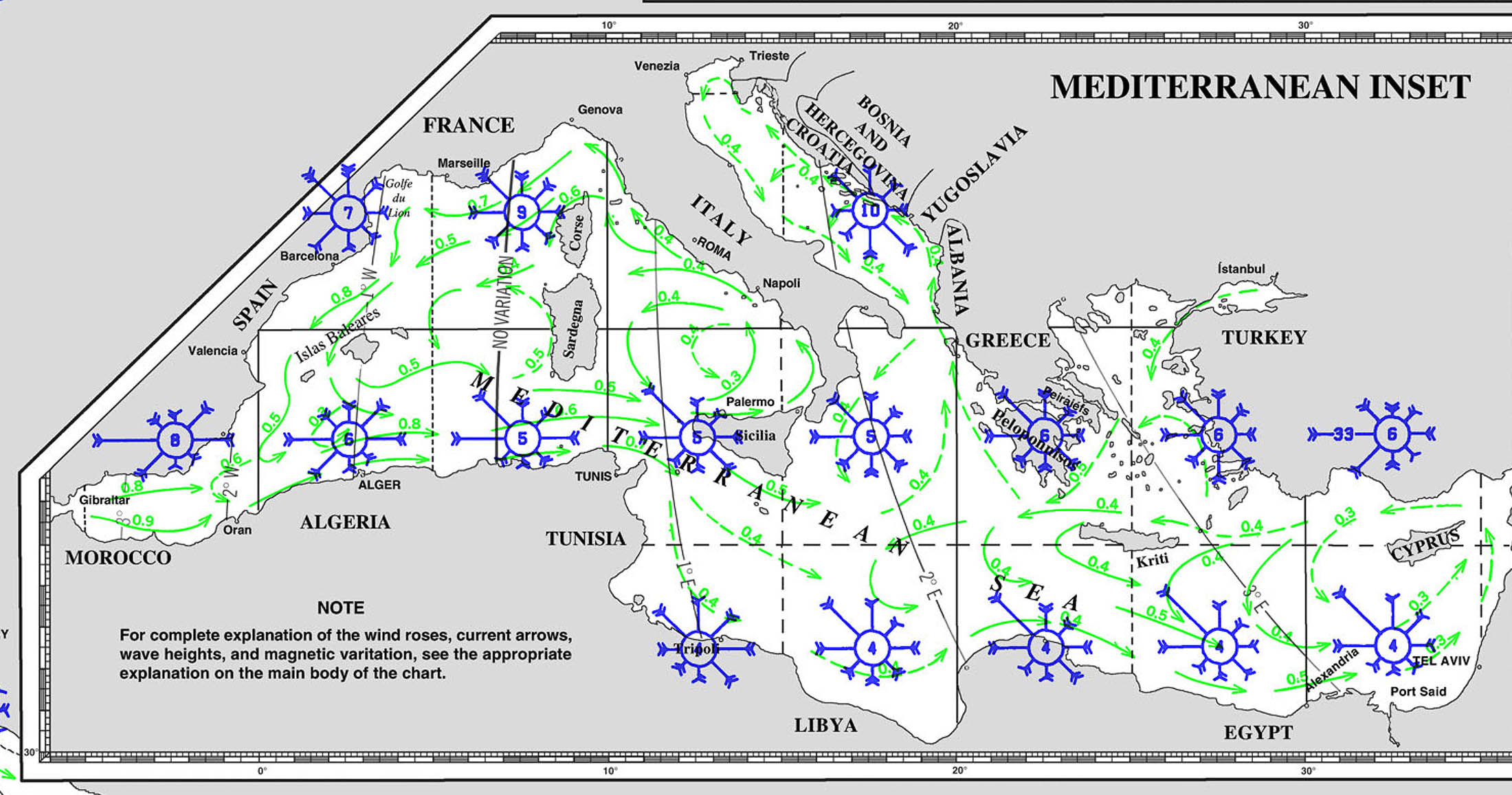
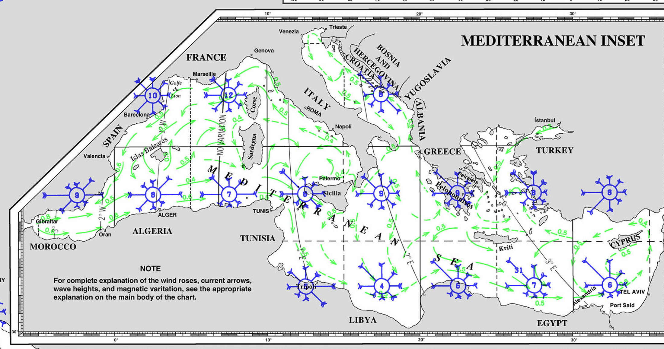
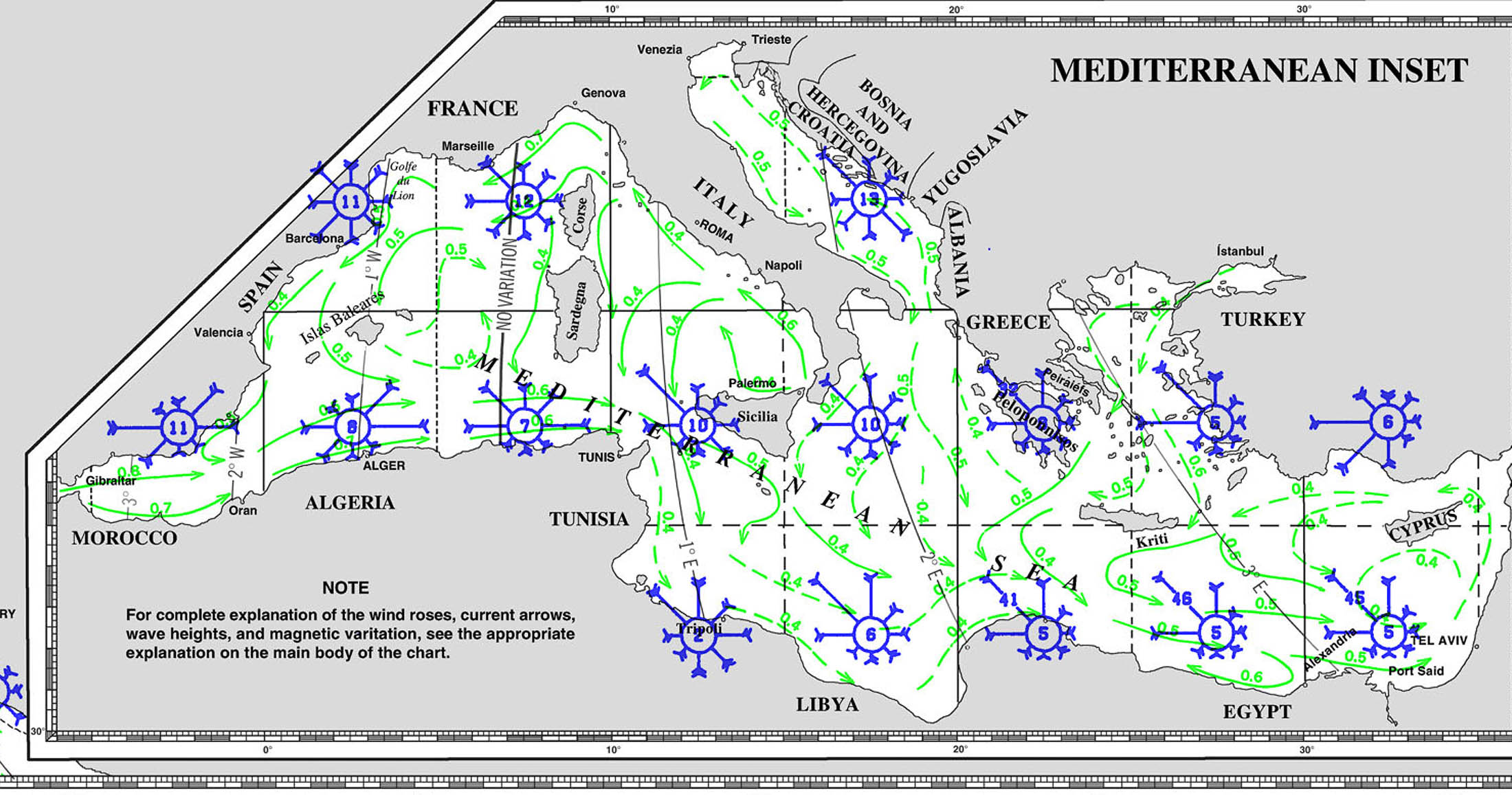
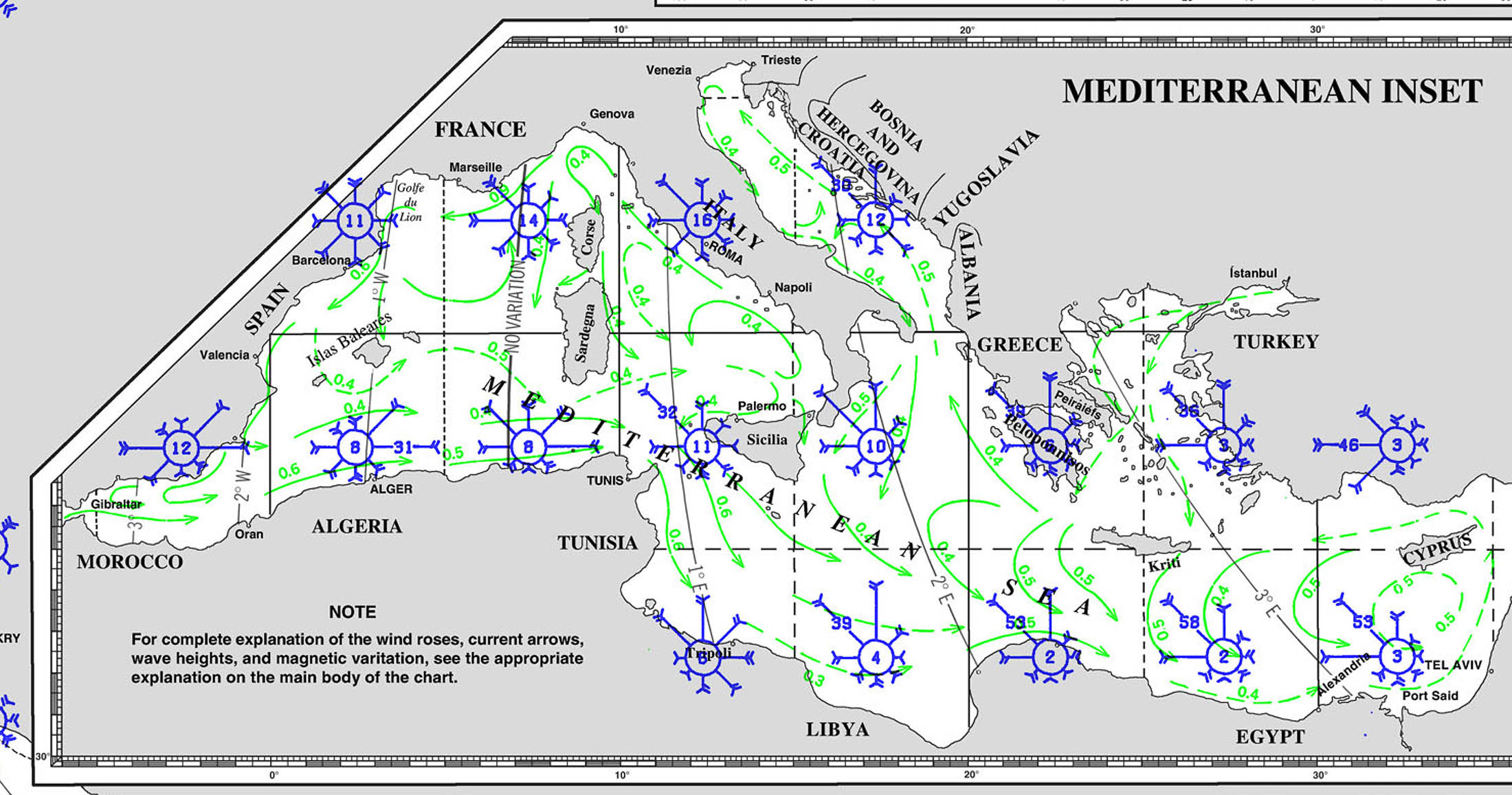
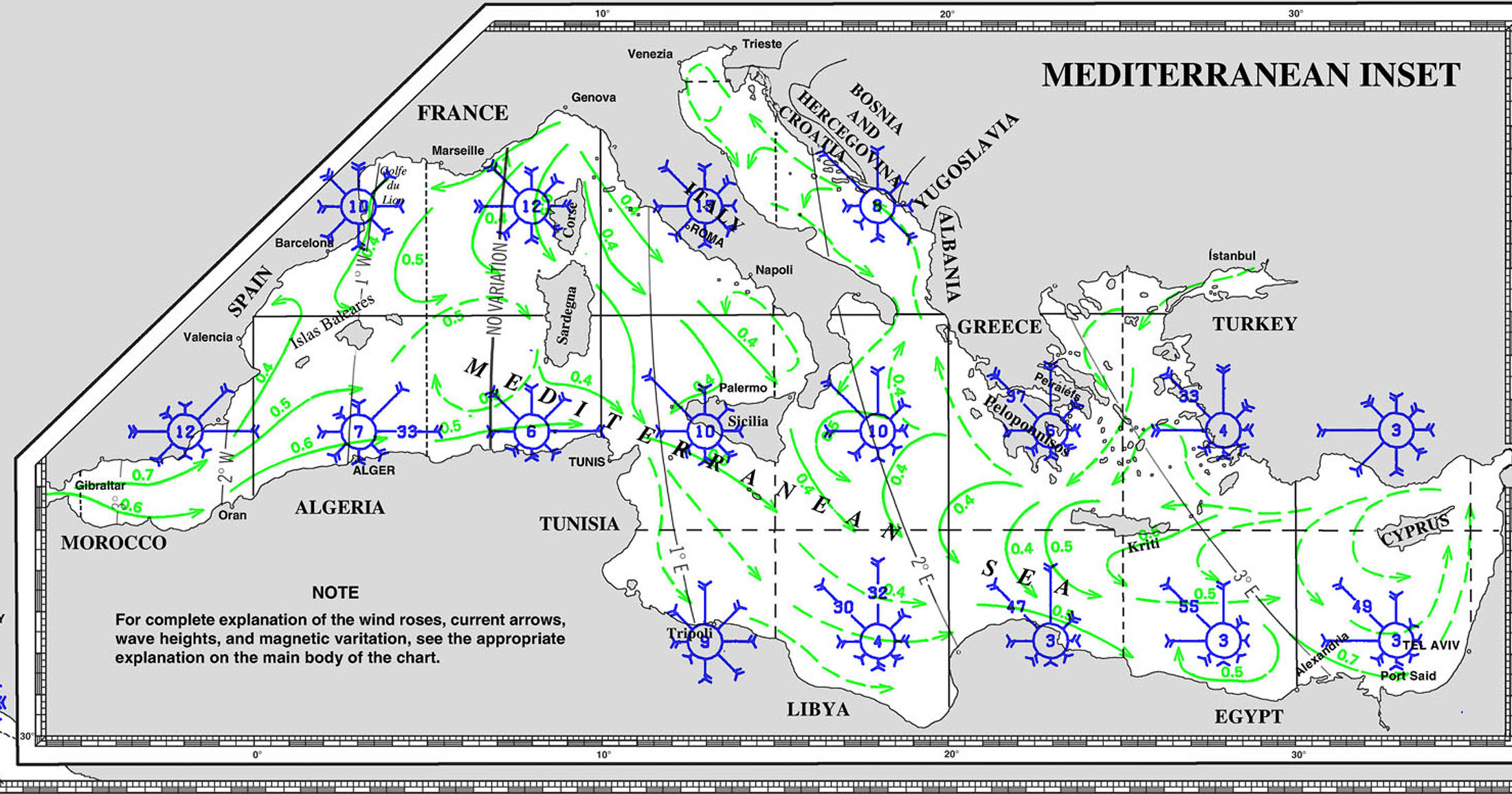
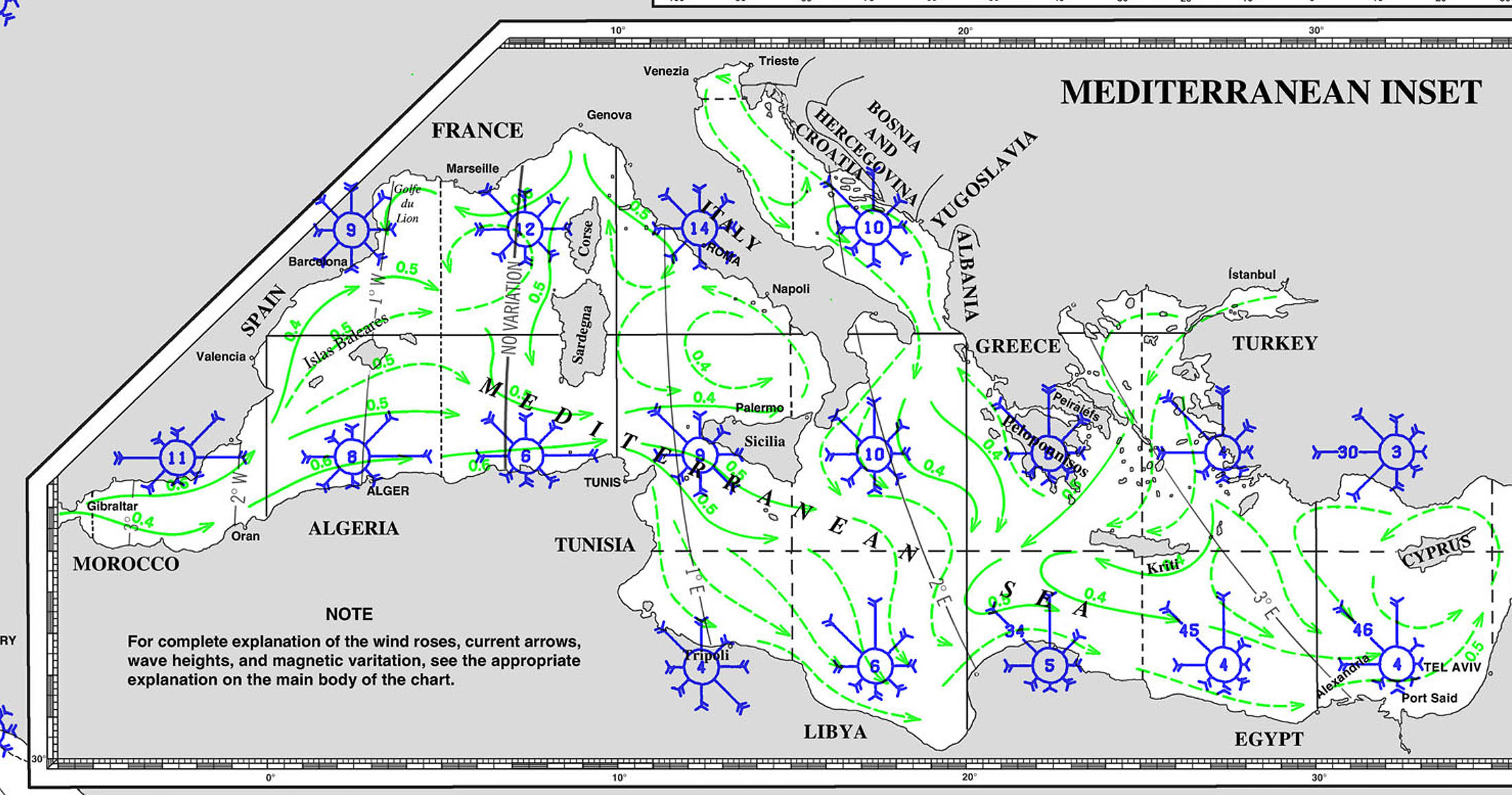

Weather Patterns
WINDS
Tides and Currents
SWELL AND WAVES
[/mepr-show]

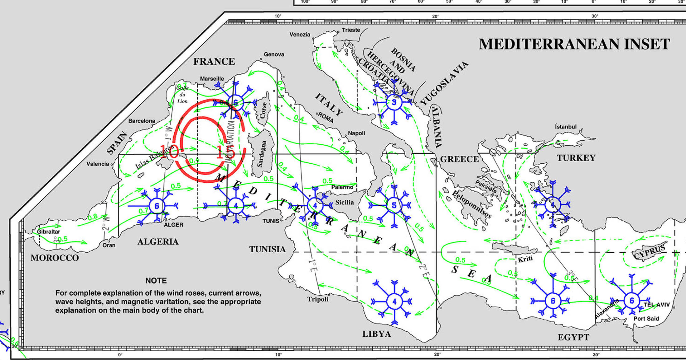
STRAIGHT OF GIBRALTAR
STRAIGHT OF GIBRALTAR
Over 100,000 ships transit through Gibraltar every year
Density of seawater in the Strait of Gibraltar One of the unique features of the Strait of Gibraltar is the inflow and outflow of the Med which consists of layers of water with different salinity (salinity). Atlantic water is less saline and less concentrated than Mediterranean water, and flows eastward into the Mediterranean through straits as a surface layer, flowing at a speed of 2 to 3 knots at a depth of about 125 m. In contrast, heavier, cooler, and saltier water flows westward into the Atlantic Ocean. Depending on the phase of the tide, the currents flow eastward faster or slower.
Tides in the Strait of Gibraltar –
A very distinctive feature of the Strait of Gibraltar is the continuous evaporation of water. Vertical water height in the Mediterranean Sea decreases by almost 1 meter every year. About 6.5+ million years ago, the general shape of the Mediterranean base was similar to what it is today. The movement of the plates cut off the flow of water from ocean to ocean, completely evaporating the area. But about 5+ million years ago, the plates moved again and the straits opened, allowing large amounts of water to flow out of the ocean and refill the Mediterranean basin. This evaporation continues today, and it is estimated that if the strait were to close at current high sea levels, the basin would evaporate again. Backwash and Internal Waves Adding another challenging piece to the tidal puzzle that shapes the Strait of Gibraltar near the African continent are the often narrow two-knot backwashes that interact with the Caminal Stile (the shallowest part of the strait) and cause internally generated waves. As stated by NASA; "The waves are generated when daily tidal pulses flow through the shallow Caminal Stile near Gibraltar. They flow eastward and break up the coastal topography. They can be traced up to 90 nm, and in some cases produce interference patterns due to refracted waves
Internal waves are vertical movements between two layers and can have displacements of over 100 m with wavelengths of 1-3 nm. They are so noticeable as surface wave patterns that sunlight is carefully scattered by the water surface
Alboran Gyre
As the upper-level flow pours into the Mediterranean, the Coriolis force (an effect of the earth's rotation) causes it to form a large clockwise eddy (gyre) off the North African coast called the Alboran Gyre. A smaller weak anti-clockwise eddy forms to the North. Countercurrents (westward direcction) can be seen close inshore along both shores, particularly near headlands that project into the current.
The western end of the Mediterranean, aka Alboran Sea, is the habitat for a largest population of dolphins in the western Mediterranean
A layer of outward-flowing dense water stays deep after exiting the Mediterranean and forms a ribbon extending along the Spanish and Portuguese coasts at about 1000m depth.
Modelling the Strait of Gibraltar
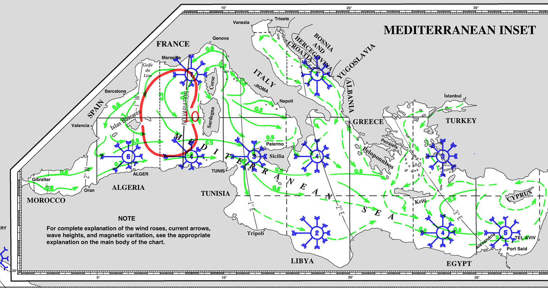
WINDS
CURRENTS
SWELL AND WAVES

COLOMBIA TO ARUBA - THE IMPOSSIBLE UPWIND ROUTE
COLOMBIA TO ARUBA - THE IMPOSSIBLE UPWIND ROUTE

WIND GUSTS

WAVES

WIND AND SWELL

CURRENTS
 2024-05-05 account from SV ROCHAMBEU
Beyond devastated. That’s how we feel right now. It’s been a while since I’ve really documented our nomadic lifestyle. We have sailed from California, USA through Mexico, Costa Rica, the Pacific side of Panama, through the Panama Canal, the Caribbean side of Panama, through Colombia’s “pirate alley”, and two thirds the way to Aruba, actually into the waters of the Netherland Antilles. We met some of the most amazing adventurous people along the way who will forever be in our hearts. Some of them we met in California and others in Mexico. Some have split up but then we meet back up and call it “bungee-boating”. Some we will never see again. But yesterday morning we split up unexpectedly, heart wrenchingly. After motor sailing for 2 days and 2 nights in benign sea conditions, the weather took a drastic turn. Suddenly while on night watch, 25 knots of steady wind came out of the Atlantic and the seas starting pounding. By daylight we were feeling drained from a lack of sleep and our buddy boats had begun drifting away. We were still fine, all communicating on VHF radio, and eagerly waiting to just get through it for another 40-50 miles so that we could wake up to sunny Aruba and eat an anticipated Dutch breakfast. (You should’ve seen how excited Rolf grew a few nights ago when it dawned on him that we were going to sail to a country where people spoke his language and he could eat Dutch food again.) But then suddenly a new tie down strap for our dinghy snapped and blew away. Shit! Because we were bashing there was a lot of force and our dinghy davits were compromised, now damaged and weakened. We had another new strap and were able to secure the dinghy. Good. But, our solar arch is also partially sitting on top of the davits and now the dinghy and solar panels are at risk of just breaking off and going kerplunck into the angry ocean. If that weren’t enough, we had a 2 knot current that we were fighting against while feeling like we were riding a bucking bull. This slowed us down to a whopping 1 knot of “speed”. We were crawling and waves were crashing over our bows every now and then. Making life go from worse to miserable, our autopilot shutoff because it couldn’t keep up with the bashing. Conditions matter. And yesterday morning was a perfect example where with rough seas, strong current, and high wind (all on the nose) was a trifecta for poor motor performance and loss of the autopilot. So we had to make one of the toughest decisions ever - either steer by hand for 2 days and crawl to Aruba or turn back to Colombia. The main considerations were the stability of our dinghy davit system, our own safety & fatigue, and the comfort of our 14 year old dog, who was clearly suffering too. We bashed for an hour debating back & forth whether we could make it safely to Aruba or turn back. The problem was that the weather forecast now indicated the wind and sea state could persist for another couple of days. So with immense sadness we turned around. 😭😭😭 Now we’re alone, sailing back down the Colombian coast to Santa Marta, maybe even back to Cartagena. Next up, we have to still work our day jobs, which can be stressful and demanding at times while we figure out how to reinforce our dinghy davits and consider replacing our props. Really, I wish we could buy a bigger and more powerful boat with tons of horsepower for the 5-10% of the time we really need to motor hard from one amazing destination to another. But for now, I’m back to the night watch cruising solo. At least we’re comfortable with the wind and swells behind us and our sails are up.


Yucatan Channel
Yucatan Channel 21° 30'N 086° 00'W
The Yucatan Channel ( 108 miles wide ) serves as a main route between the Gulf of Mexico and the Panama Canal. The E side of the channel is deep, shoaling gradually to the Mexican coast. Depths of less than 30m and named dangers extend up to 25miles off the coast, while depths of 15m and 17m have been re-ported to lie 34 miles NNE and NE, respectively, of Isla Con-toy 21 29'N., 86 48'W Tides Currents.

Tides—Currents
The greater part of the flow from the Caribbean Sea flows through Yucatan Channel towards the Gulf of Mexico. The western boundary of the current is Bancode Campeche, the bank extending 120 to 145 miles N and W of the Yucatan Peninsula. The E boundary lies about 20 miles off Cabo San Antonio, Cuba. The current axis is located about 35 miles off the Yucatan coast, about 6 miles beyond the 300m curve, in depths of 366to 731m. The mean rate during April, May, and June along the axis is about 4 knots. From 20 to 35 miles off Cabo San Antonio, the mean rate is1 knot at 50 miles, 2 knots at 65 miles, 3 knots at 78 miles, and at 90 miles, or about 25 miles from Yucatan, 1 knot. The current
AHOY !
... join the Ocean Posse to gain access to THIS AND OTHER information >>
JOIN THE OCEAN POSSE _FOR ACCESS TO THIS AND OTHER INFORMATION - SIGN UP HERE >>
ALREADY SIGNED UP ? FOLLOW THIS LINK TO LOGIN >>
The Ocean Posse offers many saving benefits in addition to validate information by fellow yacht owners >>
BENEFITS OF of joining the Ocean Posse
SAVE TIME - SAVE MONEY - and get the best and most up to date INFORMATION !
| BENEFITS FOR YOU, YOUR YACHT & YOUR CREW |
|
|
| PRE SEASON | IN SEASON | |
| ✔️ Up to date and verified information by fellow yachts | ✔️ | ✔️ |
| 📊 Communications focused on facts, not opinions or unsolicited advice | ✔️ | |
| 💰 Save real money at 70+ Marinas with discounts * | ✔️ ( June ) | ✔️ |
| 🛰️ Free vessel and fleet tracking courtesy of Predict Wind | ✔️ | |
| 🚩 Free Burgee | ✔️ | |
| 💰 Save with service providers and chandleries | ✔️ ( June ish ) | ✔️ |
| 🕵️ dedicated, experienced and discounted Canal and clearing in agents | ✔️ | ✔️ |
| 🗺️ Free aid to navigation 150 Gb OpenCPN satellite charts (mac/pc/android) | ✔️ immediately | ✔️ |
| 💰 Save Money on parts with a Westmarine Pro Discount | ✔️ | |
| 💰 Save Money with a Predict Wind Pro Discount | ✔️ | |
| 🗺️ Free Printable Reference Charts emergency backup to your electronics | ✔️ immediately | ✔️ |
| 📹 Free Video Seminars on destinations from those who are there | ✔️ immediately | ✔️ |
| 🌩️ Top weather routing avail by Marine Weather Center Chris Parker | ✔️ | |
| ⛵ Community of voyagers all are welcome, kids, single-handers, pets | ✔️ | ✔️ |
| ⚓ Peer support in emergencies with escalation procedures | ✔️ | |
| 🛈 Fleet Updates via email – free | ✔️ Prior Fleet immediately | ✔️ |
| 🏆 Fun Award Categories | ✔️ | |
| 📍 Free access to GOOD NAUTICAL Anchorage reports | ✔immediately | ✔️ |
| ☎️ Free Weekly live calls on Mondays via dedicated LINE.me group | ✔️ | |
| 💬 Free 24/7 LINE group channel | ✔️end of June | ✔️ |
| 🌊 Benefit from the latest information and prior experience participants | ✔️ | |
| 🔭 Be part of a fleet of sensor for those who come behind you or meet | ✔️ | |
| 🚷 Always priority traffic – for participants by participants | ✔️ |
- (* as long as you do not have prior contracts or reservations in place and of course subject to a marina’s availability the longer you stay the more discount the marina may give you )