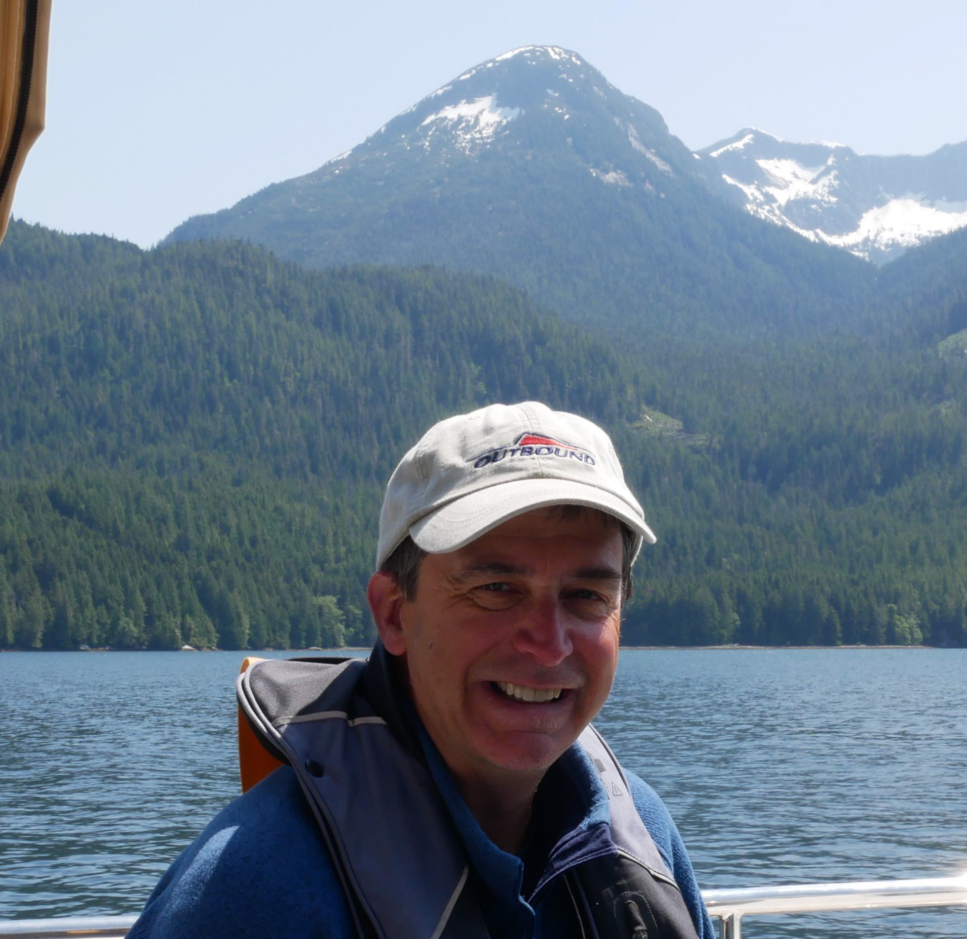
SEASON 8 AWARD ENTRIES: BIGGEST FISH CAUGHT
SEASON 8 AWARD ENTRIES: BIGGEST FISH CAUGHT

It was a blast. Tuna steaks forever. Vacuum packed and in the freezer. We weighed it with a luggage scale.

SV MALAIKA 🇺🇸 Robert & BettiAnn – Outbound 46′

LAYERS OF LIFE IN THE OCEAN
LAYERS OF LIFE IN THE DEEP SEA

From the Mediterranean to the Caribbean to the Galapagos to the Sea of Cortez to the expansive South Pacific Ocean Posse members have the opportunity to see, and in some cases, swim with a wide range of marine animals. Most marine life is seen at or near the surface in the upper reaches of what is termed the Sunlights Zone or the Epipelagic Zone. Interestingly, though what we see is in the merely upper reaches of the ocean's truly astounding depth. The ocean is unfathomably deep. The ocean is divided into various depth zones, each with its own unique environment, ecosystem, and community of creatures.
For those of us that want to enjoy some rather Zen armchair deep diving check out this video to see just how deep various creatures live and travel.


MUST SEE La Lonja de la Seda, Spain
 La Lonja de la Seda, Spain
39°28'27.7"N 0°22'41.9"W
The UNESCO Silk Exchange BUILDING in Valencia

Valencia, the “Medina al-Tarab” (City of Sand), is one of the oldest cities in Spain. The city was founded on the banks of the River Turia in 138 BC by the Romans, and began to prosper in the Andulasian period (714 AD-1171 AD). The advent of Islamic culture brought with it a myriad of trading activities related to paper, silk, leather and ceramics and placed Valencia as a commercial hub. After witnessing a brief period of decline, Valencia again revived its importance in the 15th Century, a period which is also referred to as the “Golden Period of Valencia”. They are noteworthy monuments related to the Silk Roads heritage and to the silk industry in the city. La Lonja de la Seda (Silk Exchange) in Valencia, Spain, is a UNESCO World Heritage site and an iconic example of Gothic architecture. It's a must-see due to its historical significance, stunning design, and cultural value. Here's why:
La Lonja was built between 1482 and 1548 to serve as the city's silk trading center during the height of Valencia's economic power. Interestingly, this building replaced a previous building which was called the oil exchange and was where the trade of agricultural oil and other business was conducted. The rising prosperity of Valencia in the 15th century led to the building of the Lonja, the current silk exchange. The exchange was a symbol of the city's wealth, where merchants from all over Europe and the Mediterranean came to conduct business. The building showcases stunning Gothic architecture, blending civil and religious influences. The main hall (Sala de Contrataciones or the Contract Hall), with its incredible vaulted ceiling supported by twisted columns, is a masterpiece of design. This is where merchants come to discuss and negotiate contracts. The twisted columns were meant to look like palm trees branching into the sky. The columns themselves were painted brown, the branching up high green, and beyond, blue. While the hall is still stunning today, this painted palm forest was surely a very different look than the bare sandstone of today and must have been very impressive.

The patio and the tower are notable parts of La Lonja as well. The Patio, or inner courtyard, has an open-air design that is stunning, offering an insight into the architectural ingenuity of the period. The tower is fortified with defensive features, symbolic of the importance of the building in the city's trade and security. It is said that traders who were found guilty of fraud were imprisoned in the tower. The ornate detailing in the form of carvings and sculptures is another highlight of the building's grandeur.

In 1996, La Lonja was designated a UNESCO World Heritage site for its exceptional contribution to the architecture of Europe and its importance to Valencia's historical development. It remains one of the best-preserved examples of civil Gothic architecture in Spain. It stands out among this style of architecture as well for it is among the few that was not a church or a cathedral. Inside, visitors can admire a series of frescoes and sculptures, as well as a collection of artworks that showcase the wealth and artistic sophistication of the time. The building also houses exhibitions about its history and the importance of the silk trade in Valencia's rise as a Mediterranean commercial powerhouse.


Silk fiber production process

Loom in the Requena Silk Museum. / Image provided by Ester Alba
The main activity of the Valencian silk industry from the fifteenth to the end of the seventeenth century was the production of silk fiber, a job that was carried out intensively from March to June. “The production of silk fiber was a very intense activity carried out in a very specific season, but it was vital for the survival of peasant families”, explains Professor Ricardo Franch. It started by warming silkworm eggs through different methods, like using body heat or the warmth of the sun, but not before a ritual that involved bringing the silkworm eggs to the church to bless them. The enormous dedication required by this process was due to the fact that the income was obtained in June, coinciding with the payment of different leases. Thus, silk harvesting was essential to obtain the income needed to meet the economic demands of peasant families. When June arrived and the worms had already finished the cocoon, the silk was spun. This work, carried out mainly by women, was hard and left its mark on the hands of the peasants who pulled the thread after soaking it in hot water.
It's easy to visit La Lonja as it is centrally located in Valencia, close to other historic sites, such as the Central Market and Valencia Cathedral. The building is open for tours, and it's often less crowded than other famous sites in Spain, allowing a more relaxed visit. La Lonja de la Seda is a must-see for anyone visiting Valencia due to its stunning architecture, historical significance, and status as a UNESCO World Heritage site. It beautifully represents the peak of Valencia's commercial and cultural influence in the Middle Ages, making it a vital part of the city's heritage.
https://oceanposse.com/spain/

POSSE SPONSOR PREDICTWIND ADDS NEW LIGHTNING FEATURE
OCEAN POSSE SPONSOR PREDICTWIND
ADDS NEW LIGHTNING FEATURE

Predictwind supports the Ocean Posse with free tracking and a [ must be logged in to see ] 20 % Discount off our pro packages – to claim your discount please login and email support@predictwind.com with your vessel name and email address.
For those of you with paid subscriptions to Predictwind they rolled out new features this week that send extreme weather alerts and show lightening predictions- pretty cool go check it out!
Powerful features to keep you in control.
Weather forecasts and industry-leading marine tools to make your next adventure simpler, safer and more enjoyable.

MV TIDINGS OF JOY VISITS AN EMBERA VILLAGE
MV TIDINGS OF JOY VISITS AN EMBERA VILLAGE


Tidings of Joy took a guided tour of the native village of the Embera tribe in Panama recently. Here is their trip report:
Our wonderful guide Goran (+507 6314-0827) picked us up in front of Flamenco Marina and drove for a short, one hour drive outside the city to Chagres National Park. We watched the buildings, traffic and. noise melt into green lush trees, birds and silence. When we arrived at the parking lot, we were met by two native Embera men wearing traditional clothing. Our guide mentioned this isn’t their everyday wears but when there is a celebration, or they want to demonstrate their culture they will wear them. We walked down to a long, narrow wooden boat with single rows of seats that didn’t appear very sturdy at first glance. As we filed in one by one we were careful to walk in the middle to not tip the boat. One native man drove the outboard powered boat from the stern while the second man stood watch on the bow using a homemade wood pole as both a spear and a seat.


The river was long and somewhat shallow in spots and wrapped in green voluptuous trees. Birds flew overhead as we wound our way down the river. Our first stop was a forest where we walked on a muddy path over rocks and through streams to get to a gorgeous waterfall. Despite the water being a little chilly we all plunged in and swam to the waterfall. It felt freeing and safe and perfect. After we finished gallivanting in the water we made the trek back to our wood boat and carefully piled in. Our next stop was at the Embera village where women in traditional clothes greeted everyone individually shaking our hands and saying “welcome/bienvenido” as we walked up the slight incline towards the village. As we got closer four Embera men were standing in a line playing traditional music welcoming us. We were all seated in one of their two communal kitchens and observed two women frying up fish and plantains in a cauldron full of oil. While we waited for lunch to cook a different native woman stood in front of us and told us about their rich and vast history. We learned that the Embera tribe was not always from this area but used to reside down in the Darian region but because the boat ride full of fresh fruits to sell in the city took 7 days causing all of their food to spoil, they decided to move closer to the city. In this Embera village there are only 25 families. Each one lives in a homemade wooden house elevated 5-6 feet from the ground to prevent flooding and minimalize animal invasion. Children are taken by boat to school in a neighboring village where a teacher from the city teaches them Monday-Friday before returning to the city for the weekend. Presently, tourism is their main source of income. Each day men go out fishing and bring their catches back for the woman to prepare for the days meals. After our education about the Embera tribe we feasted on a lunch of fried fresh tilapia and fried plantains all served in a banana leaf wrapped in the shape of a bowl and a table full of fresh fruits the guides had provided. With full bellies and a lot to think about we were escorted into a large communal hut we were told was used for ceremonies and communal gathering. The locals had tables surrounding the perimeter filled with handmade crafts for sale. They wove baskets and plates and bowls along with jewelry and fabric they had created the designs for. Some of the men had wood carvings for sale of various animals and even wooden knives which Jeff decided he needed to have. After a brief lap around we all sat on wood benches and watched as the native woman performed traditional dances. Several men surrounded them playing instruments while they chanted and moved around. They even encouraged audience participation, and I sat watching as Jeff was escorted around in a circle hand and hand with a native woman teaching him their dance. All of the woman tourists were given homemade flower crowns to wear home. Embera felt like a peaceful eutopia and a wonderful pause from all of the commotion and chaos of everyday life. A tour we would highly recommend.

THANK YOU FOR SHARING YOUR EXPERIENCE!
MY TIDINGS OF JOY 🇺🇸 Jeff & Joy - DeFever 52′
![]()
![]()

MARINA PAPAGAYO 🇨🇷 SPONSORS THE OCEAN POSSE
MARINA PAPAGAYO 🇨🇷 SPONSORS THE OCEAN POSSE
Marina Papagayo is proud to continue our sponsorship of the Ocean Posse fleet for the 2024/25 season. Our dockage discount for Posse members is:
Stay three nights pay for two
Stay for a week and pay for five days
Stay for a month and pay the annual monthly rate
Complimentary drink coupons for the Dive bar on arrival
We look forward to welcoming you to Marina Papagayo.
Best Regards,
Dan

https://oceanposse.com/marina-papagayo
Costa Rica is a very beautiful country to visit by boat all times of the year. Their biodiversity is protected and is a highlight from the coast to the mountaintops. Costa Rica is also out of the hurricane zone. Just lightning and thunder. A few Panama Posse vessels summered at Marina Papagayo and report that it gets way less rain and lightning/thunder compared to south CR like Golfito.
SV MAISON DE SANTE spent a hurricane season at Marina Papagayo:
A special shout out to Marina Papagayo and manager Dan for being a Panama Posse sponsor! Such a beautiful eco-conscious marina with everything you could ask for: potable water, complimentary pump out services, laundry, gym, pool, game room, hot showers with good water pressure, 24 hour security, recycling, mini market, marine store, and concierge services. There’s a nice walking trail to beautiful beaches and restaurants where you are likely to encounter all kinds of wildlife like deer, iguanas, and monkeys. The marina is so clean, you don’t have to think twice about cleaning the bottom of your boat (or running the water maker). A pet friendly marina with wonderful staff! I would highly recommend this marina to anyone visiting Costa Rica!


Season 8 Burgees are going UP
SEASON 8 BURGEES ARE GOING UP


COOKIES AND FARADAY CAGES
COOKIES AND FARADAY CAGES
*Seasonal Provisioning Tip*
This time of year you can get huge packages of food (cookies, chocolates, crackers) in special seasonal ‘cookie tins’. We on SV AVANT go crazy and stock up on them.
We keep the tins to use as faraday cages (store smaller portable electronics in them to protect them from the effects of a nearby lightning strike).
BONUS: Consumption of the contents can improve morale, as well.


SY AVANT 🇨🇦 Rob & Debra – Beneteau 43.5


Thanksgiving 2024
HAPPY THANKSGIVING

Happy Thanksgiving to All
Admirals, Captains, Skippers, Quartermasters and Crew,
May your anchors set in a deep broad bed of sand,
your sails, hearts and bellies be full.


This Thanksgiving there are many things to be grateful for. The open seas, remote anchorages, coves, beaches and oceans are still the best source of fresh air and wellness for explorers and seafarers alike. We reflect on all the things to be grateful for —friends, family, loved ones, and a well charted course are things to be cherished We want to thank you for being part of the Ocean Posse: a group of exceptional individuals who look at the horizon each day and say “where to next ?”
We are thankful to our Marina Partners and Sponsors who will host us, help us to re-provision, refuel, resupply, and rest so that we can get underway again.
Ocean Posse Team
Dietmar, Maurisa, Nicole, & Rob
![]()


TO STOP OR NOT TO STOP IN THE GALAPAGOS?
TO STOP OR NOT TO STOP
IN THE GALAPAGOS?

The Galapagos is undeniably on many a cruisers bucket list. However, depending on ones drive, timeline, and/or cruising budget, the in's and outs of navigating the entry requirements and fees can be anywhere from reasonable and attainable to impractical and impossible. Every year Ocean Posse boats are crossing the Pacific Ocean. Some boats plan a stop in the Galapagos, some boats make an emergency stop, while others still pass by en route to the Southern Pacific Islands further west. Erick and Jennifer from SV WINDSONG are among the fleet that planned their stop, made it happen, and adventured through the Galapagos. Here they share their experience getting the approval to stop, the real fees they incurred, and their adventures during their stay. Please Note: regulations and requirements change often so the exact requirements today may be slightly different. Resources are provided to get up to date information.
ERICK REPORTS:
As sailors begin to prepare their journey from the Americas to the South Pacific, the decision on whether or not to stop at the Galapagos islands looms for many. For most cruisers, the choice boils down to three factors: the activities and attractions in the islands, the cost of entry, and the hassle for cruisers to prepare and visit the islands. When my wife and I began our sail to the South Pacific from Panama in early 2023, we were enticed by the Galapagos and had ultimately decided to make the stop. We had no regrets, in fact, it was one of our favorite places we have ever been to. I hope this article gives readers a better understanding about the positives and negatives concerning the Galapagos stop, or at least give the readers better insight before making their decision.
Ocean Posse members work with Yacht Agents Galapagos: (/yachtagentsgalapagos.com) to handle all of the clearance and entry requirements. Agents are required for visiting yachts, and we were very happy working with Javier and his crew. For details and specific information regarding many of the requirements, costs, activities, restrictions and opportunities for cruising yachts, visit their website.
The very first factor cruisers should consider is why they should or shouldn’t stop in the Galapagos at all. For us, the islands hosted a wide array of incredible experiences that we couldn’t pass up. We were always enticed by the natural wonders of the islands, mostly as animal lovers and the opportunity to come face-to-face with unique and intense creatures. From the very moment you arrive at San Cristobal to clear in, you are greeted by the sea lions frolicking around the anchorage, audible with their distinctive barks. Many will be seen sleeping alone or in groups on unattended local boats, or even on some unprepared cruising yachts. We found them hilarious and endlessly entertaining. Other boats found them to be loud, stinky, obnoxious and more of a hassle. Aside from the sea lions, the islands offer wild experiences encountering sea turtles, giant land tortoises, a variety of unique birds, penguins and more! Our first warning here is: if you are not at all interested in animal encounters, you may not want to consider the Galapagos.


The islands offer a wide array of activities for many different interests and budgets. Many will enjoy world class scuba diving with abundant sea life that is rarely rivaled in the world; others will want to experience as much of the diverse landscapes such as the various volcanoes through hikes and tours, along with the intimate animal encounters wherever you go. A little known secret of the Galapagos islands is the world class surfing to be had for all ability levels. The exceptional and uncrowded surf breaks were the icing on the cake for us and our visit. While cruising between islands in the Galapagos, we experienced the most consistent and exciting offshore fishing on our entire cruise between Florida and Fiji. We had more tuna and mahi mahi than we knew what to do with, and made some life-long friends on other boats by sharing our catch.


When considering the long passage from the Americas to French Polynesia, the Galapagos islands seem like a nice stop along the way, particularly after the often frustrating slog through the doldrums. However, if the activities and abundant wildlife do not sound like something you are seriously interested in discovering, then I would suggest possibly skipping the Galapagos. Many cruisers we have heard of who chose to enter just for a convenient stop, rest and refuel are often the ones who will speak poorly of the experience. Many do not appreciate the frisky sea lions trying to board their vessel, find the cost of entry too much for just a convenient stop, and the entry requirements an extreme hassle.
If the wildlife and activities sound like a great idea to you, the next consideration would be the cost of entry. We knew this was a bucket-list item for us, and we would forever regret sailing past the islands. However, we are a low-budget boat, so we saved and trimmed other expenses to specifically afford the trip to the Galapagos. The fully loaded cost for entry for our vessel with 2 people was $2,277.60, including the Pacific Posse discount. The details of each cost are shown in the invoice image below. Certain costs scale by the amount of people on each boat, and the type of permit you seek for cruising. Please be mindful these costs were for our visit in March 2023, prices are subject to change.


Beyond the cost of entry, the cost of staying in the islands should be considered. We spent our full 30 day stay included in our fees, maximizing our time and value for the cost. By being able to stay on our own boat, we ultimately saved money for a comparable month-long stay by flying in and paying for lodging, food without our own kitchen, travel between islands, etc. Once in the islands, cost of living is not expensive especially compared to places down the line such as French Polynesia. Budget eating is easily accomplished, with delicious $5 USD Ecuadorian lunch specials that typically include a hearty stew, filling entree and fresh juice. Combined with the decently priced fresh produce, one can eat well on a budget with the boat’s galley available. There are also restaurants and bars for every other budget, including some great fine dining.
While in the islands, your activities can be tailored to your budget. We aimed to avoid costly tours as much as we could; opting to entertain ourselves with self-guided hikes, snorkeling from shore, walking to or taking cheap taxis (land and water) to different surf breaks, renting bikes to get around instead of cars, etc. Scuba diving and many of the more extensive tours will cost extra, as well as trips to the remote islands where cruising yachts do not have access.
The final consideration for stopping in the Galapagos for many cruising yachts is the hassle of entry. The requirements for entry are described on Yacht Agents Galapagos’ website, and their agents made the process easy to follow with checklists and frequent communication every step of the way. We can only speak of our experience preparing for the trip from Panama, where not only did Yacht Agents Galapagos make our lives easy, but also Ocean Posse Panama Canal agent Erick Galvez from Centenario Consulting. Erick offered extremely valuable services by arranging for many of the pre-trip requirements including the required bottom cleaning and fumigation certificates, as well as full service exit clearance help with the customs and immigration in Panama City. We had the benefit of beginning preparation many weeks ahead of our departure. If your schedule is very tight from transiting Panama or other ports to the Galapagos, then the hassle of preparation might be too much.
Beyond the preparation, the arrival procedures for the Galapagos islands can seem overwhelming, another potential turn-off for some cruisers. We first arrived at San Cristobal, the traditional check-in port for cruisers, and were greeted by a boat with divers who inspected our hull bottom before we anchored. We had stopped one day out from arrival in calm seas to give our hull one last cleaning, which we found necessary as some small barnacles had grown on our passage from Panama. If the boat bottom has growth, the officials will require you to sail far offshore and have a professional clean your boat before arriving. The divers found our work to be satisfactory, and had us proceed into the anchorage to await the clearance formalities.
After a brief wait at anchor, a boat arrived with an impressive amount of people from various sectors of the government, including our agent’s crew to aid with the process. We have a smallish boat, and have never hosted large gatherings before. The 10 people who came to our boat represented the most people we have ever had on our boat at one time! While overwhelming, we found the process was not overburdensome nor too intrusive. We were well prepared for the process and what would be inspected thanks to the checklists and instructions provided by the yacht agents, and after about 30 minutes we had all of our clearances and were prepared to enjoy the islands.
In summary, each yacht has different aims in what they want from their cruising adventure. If the unique natural environment, animals and world class activities available in the islands appeal to you; consider the cost and potential hassle of entry. If each consideration passes your muster, begin preparation as soon as possible by contacting Yacht Agents Galapagos and get the ball rolling. Like us, you may find that this stop becomes one of the most amazing parts of your entire cruise and an unforgettable experience.

THANK YOU FOR SHARING YOUR EXPERIENCE!
SV WINDSONG 🇺🇸 Erick & Jennifer - Downeaster Cutter 38′