

CARIBBEAN LAP REPORT SV JUBEL
SV JUBEL'S CARIBBEAN LAP

SV JUBEL just finished their 1 year lap around the Caribbean. BRAVO ZULU! Here they share their story:
We are currently in progress building an HH44 Catamaran in Cebu, Philippines, which will be completed in January 2026. It's our plan to cross the Pacific to meet the boat so we can move aboard directly from JUBEL. But we didn’t come all this way from Vancouver island to skip the Caribbean. Having crossed the (Panama) Canal in September 2023, we spent some time in Bocas del Toro, the San Blas, Panama, and Cartagena, Columbia. Knowing we wanted to see the Caribbean, we decided to do a speed loop of the Windward and Leeward Islands.
The trip started from Cartagena, Colombia and we set off for Puerto Rico, or maybe the DR, on March 26th, 2024. We didn’t know where we would end up. We had heard this passage was notoriously bad, and that we may have to divert westward. So loaded with 8 extra jerry cans of diesel, we set off, along with our friends on SV VIA, a Caliber 40LRC (that holds 400+ gallons of diesel!) This trip was exactly what they say it was. We motored for 700 miles, into the wind and the waves. At times doing 3 knots. We broke our davits due to the constant slamming into the waves. We also had some flat calm days. Overall, we sailed about 10 hours out of the entire 6 days.
We ended up in Boquerón, Puerto Rico. We spent time cruising Puerto Rico for a month along the southern side of Puerto Rico, and flew home in (to Canada) in May. Our highlights are Isla Caja De Muertos, where you can hike up to the top of an abandoned lighthouse, and Isla Culebra for its snorkeling and coral farms, and of course, Costco in San Juan.

With our boat loaded with a years worth of Costco supplies in Puerto Rico we made our way to the USVI’s where it was a surprise that they drive on the opposite side of the road. We spent a few days in St. Thomas, of course, stopping at the pizza boat where we attended a massive memorial day party hosted on a catamaran while we floated in the water.

A few days on the northern side of St. Johns before making our way to the BVIs. We have a dog on board so this was pretty difficult to sort out, as you have to have a lot of paperwork and health check proofs. We met the vet in Soper’s hole where he had to inspect Ricky, our dog, in person. Once that was dealt with we made our way to pussers for a rum! This was the first island we considered “the Caribbean”, and we made it!
We spent three weeks bouncing around the BVIs including Norman Island (and the infamous Willy Ts, where we floated behind it in our Sunchill, met friends, and had beers thrown into our pool!

Anchoring at the Baths, (where our engine died coming into the anchorage, that turned out to be ricky leaning on the shutoff button!), and spending time in Virgin Gorda was also great. Our favorite anchorages were Savannah bay, and the north side of Prickly Pear Island. Having the Rum Runner bring us blended cocktails right to our boat was (also) a highlight, along with visits to Saba Rock.
From The BVIs we checked out and headed to St. Martin, stopping at the French side first. The beaches here were phenomenal. While a little run down, its very pretty, and the French food supply is amazing. We had FKG rigging come out to the boat by dinghy to give us an estimate for the standing rigging replacement that we needed. They gave us a very, very reasonable estimate and we headed over to their dock on the dutch side to have the work done. A week later, everything was brand new. Highly recommend them! We also had a new generator motor shipped here and replaced that, as our previous one had water ingress due to a manufacturing defect. St. Maarten is an amazing location for boat work and supply, especially since its all tax free. There are also great restaurants here, where we met up with some other Young Cruisers and talked shop, so we will definitely come back at some point. St. Maarten is a hit on our list!
Our next stop was Guadeloupe. It was here that we rode out hurricane Beryl. On the west side of the island behind the mountain, we set out a 10-1 scope in 20 feet of water. Luckily (for us, certainly not the islands south of us) it headed south. We were hit with 35 knots of wind and a ton of rain, but otherwise, unscathed. After the weather cleared, the view was beautiful.

We worked our way down Guadeloupe, and anchored in some very rolly anchorages - There is not much for protection on this side of the island. We stopped in several hot springs and enjoyed the natural hot water that comes out all over the island. After an absolutely brutal sail crossing from Guadeloupe to Terre-de-Haut, a group of small islands south of Guadeloupe, we went to explore and island and old fort. There is a really cute little town (but not much for food available) that you can explore.

From there we made our way to the jewel of the Caribbean, Dominica. I can not say enough about this place. It is, by far, our favourite locale in the caribbean. Absolutely untouched and unspoiled. There were no tourists, the locals were the friendliest people we have ever met, and would do anything for you. The natural beauty of this island is absolutely stunning.Waterfalls, valleys, hot springs, gorges - It has it all.

What it doesn’t have are services, restaurants, fuel docks, or supply shops. You are on your own. So bring what you need, and stay as long as you can. We grabbed a mooring ball in Portsmouth bay for $10 a night, where the PAY (Portsmouth Association of Yacht Services) will come out to the boat and give you anything you need, and help you check in. We rented a car from a local company (that we had to swap out three times because they were not in great shape - Old cars imported from Japan), they also drive on the British side of the road (in Dominica). Its like driving in the game “crazy taxi”. We drove all over the island over 5 days.


We went to visit Titou gorge where they filmed parts of the Pirates of the Caribbean

Overall, Dominica gets a 10/10 for us. We will be back to this island before our cruising career is over. Its got so much to offer, and so much that we haven’t seen, for a small island. Our provisions were running low so it was time to carry on. We made our way to Martinique from here, where we knew we could provision. And provision we did. Wine, cheese, butter, oh my. The French have food nailed down. We were here during a summer festival and I have never seen so many boats on the move, ever.

Martinique was the busiest place we’d ever been. The bays were full, with hundreds if not thousands of boats. It was way too busy for us. And they’re very not dog friendly. So after we provisioned, we carried on down to Grenada. We skipped St. Lucia for safety concerns, and therefore had to skip St. Vincent and the Grenadines due to our dog and rabies rules. That, and its been hit hard by Beryl at this point.
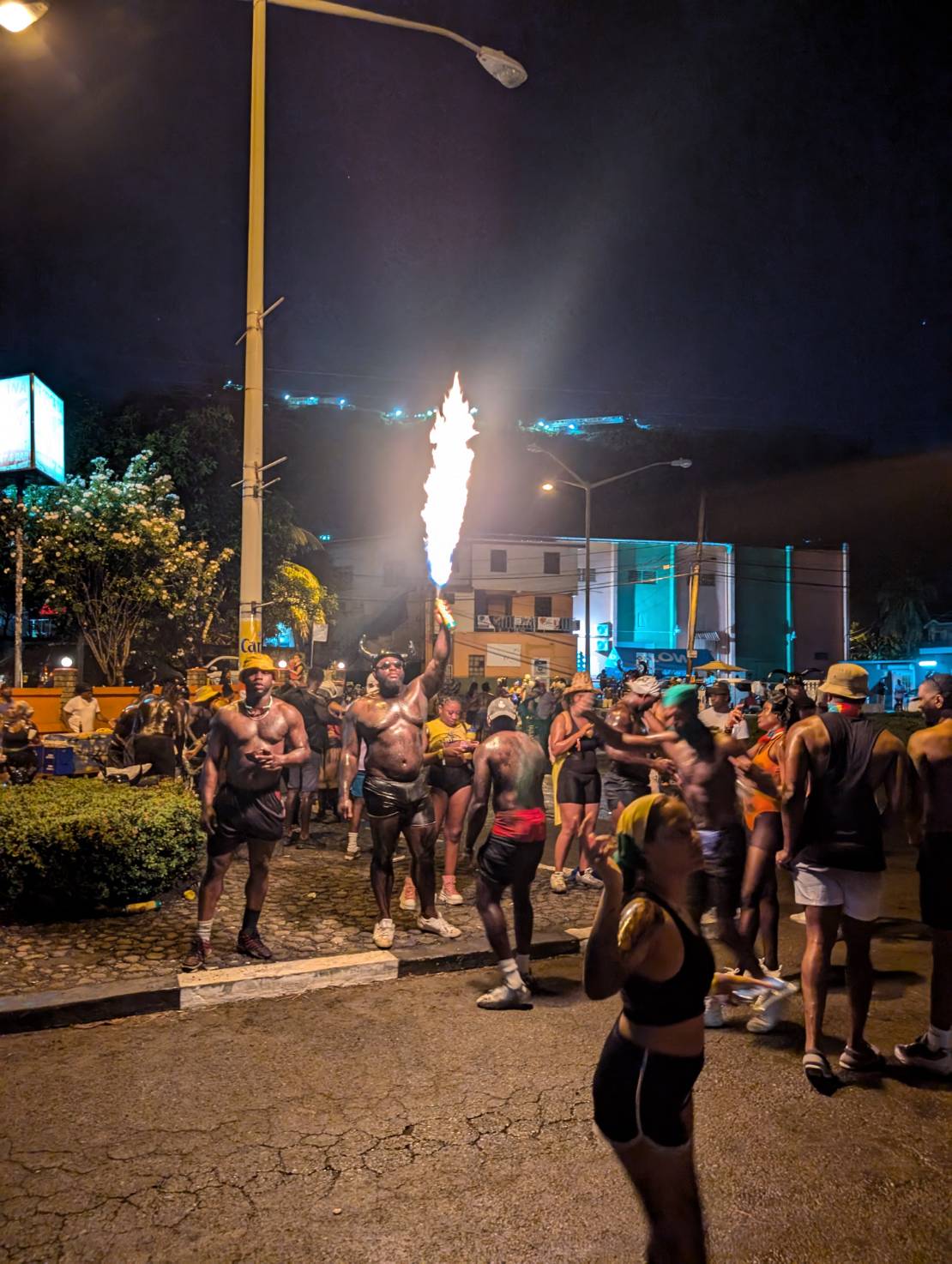
Grenada became our home for about a month and a half while we waited for hurricane season to subside slightly. The next stop after this was Bonaire, so hurricanes weren’t a big concern. We met up with friends, enjoyed copious wing nights, went snorkeling, and hauled out because we had won a free haul out from Spice Island Marine at the Young Cruisers Association Cruisers Awards. We were here for Carnival which was amazing.

We had tried out all the anchorages and there was a weather window coming. It was September at this point, so it was time to carry on to Bonaire. After a sporty 3 day sail downwind (oh how nice it was to go downwind finally, after beating our way east all the way to Dominica), we arrived in Bonaire. The water clarity blew our minds.


However, the lack of Starlink was frustrating after having it for so long. So back to a cell phone data plan we went, we spent our days snorkeling and swimming. We rented a car and drove around the whole island, stopping to feed the roadside donkeys apples and carrots.

Bonaire was definitely another highlight. The freediving and snorkeling is amazing. Its everything its cracked up to be.
We skipped Curacao and headed to Aruba to meet friends and for my parents to fly in. We loved Aruba - Dove on a shipwreck, swam with turtles, went out to fantastic restaurants, played some slot machines, had some pool days at the Hyatt pool, and even found a Canadian bar that had Poutine and took Canadian money!
Now here we are in Cartagena once again, having crossed our track when we left 8 months ago, so very happy we traveled where we did and saw what we saw. The experiences will stick with us forever, and we hope to go back to some of the islands once again in the future. Now, its time to go back to San Blas one more time before we prepare for our grand adventure across the Pacific!
SY JUBEL 🇨🇦 Leah & Kyle - Gulfstar 44'

THANK YOU FOR SHARING YOUR HIGHLIGHTS FROM YOUR 8 MONTH CARIBBEAN LOOP


Different Ways of Eating Raw Fish Across the Oceans
Different Ways of Eating Raw Fish
Across the Oceans
People living coastally or on islands are deeply connected to the ocean for their sustenance. Eating raw fish is common across many cultures around the globe, each with its own unique traditions and methods for preparing and enjoying this delicacy. Here are several different ways raw fish is eaten as a main dish across the Oceans that the Ocean Posse cruises:
1. Ceviche (Latin America)

Ceviche has it’s roots in the northwestern region of South America that are now
known as Ecuador and Peru. Overtime the dish has spread throughout Central America with each country, each region, each family adding their own touch of individuality. Ceviche is the result of fish (often Mahi mahi, snapper, or corvina) and/or other seafood (for example shrimp, conch, or Octopus) being submerged in salt and lime juice. The chemical process that occurs is similar to fish getting ‘cooked’ in which the flesh turns opaque and gets firm…although the fish is not truly cooked.
The additional ingredients, the presentation, the size, and the accompaniments vary greatly depending on where you are. For instance, along the Gold Coast in Mexico ceviche is commonly a mix of fish or mixed seafood with tomatoes, onions, jalapenos, and cilantro served on a large platter with a basket overflowing with various large corn disks called tostados. Further south, in Panama, ceviche is commonly served in small individual servings with diced onions and lots of juice and a small singular packet of crackers. Further south still to Peru, the birthplace of ceviche, raw fish is marinated in lime juice, as well as thinly sliced onion. The dish is served with sweet potato slices, small portions of toasted corn, and plantain chips. They are all DELICIOUS ….just different….and sampling ceviche along the route is highly recommended.
2. Poisson Cru (Polynesian and South Pacific Islands)

The name poisson cru literally translates to "raw fish" in French. For many centuries native Polynesians and people of the South Pacific Islands were harvesting reef fish and pelagic fish and coconuts as a mainstay of their diet. The preparation was once as simple as pouring fresh squeezed coconut milk over raw fish and has evolved to include lime juice after the Europeans introduced citron (limes). Poisson Cru has a distinctive flavor and texture that is generally more mild that ceviche. While it is sometimes compared to ceviche due to the use of raw fish and citrus juice, poisson cru has its own unique preparation and cultural significance. Poisson Cru is often served with or over rice or taro with cucumbers and/or tomatoes. Seasonal and regional twists include adding fruits like mango or papaya or other vegetables like carrots or avocados. Salt and Pepper may be added for flavor.
Poisson Cru is made at home, during celebrations, and often served at communal gatherings or feasts. It is considered a symbol of hospitality and represents a longstanding connection to the sea. The preparation and sharing of poisson cru are deeply embedded in the social fabric of Polynesian life.
Overall, poisson cru is more mild and creamy while ceviche is more tangy and snappy. Both are fresh, crunchy, and scrumptious.
3. Poke (Hawaiian Islands)

The word 'poke' (like 'okay') was a Hawaiian word that meant 'to cut crosswise into pieces'. The dish that has taken on the name Poke is one that stems from one of the staple foods of the early Polynesian people of Hawaii. The early Polynesian people of the Hawaiian Islands lived off the sea. It is said they often cut crosswise and salted raw reef fish cutoffs and seasoned this with seaweed and roasted kokui nuts. Over time, after the arrival of people from the continents to the east and the west, this staple food began to evolve and take on tastes and flavors from both sides of the ocean. For example in the late 19th century many Japanese workers immigrated to Hawaii as sugar and pineapple plantation laborers. Instead of using salt and seaweed to season their raw fish they used shoyu (soy sauce) and sesame oil. They would eat this fish with white rice. In this way, some say that the Japanese immigrants also introduced the rice base to the modern day Poke. Westerners are said to have introduces spices, onions, and chili peppers. Poke of today is a serious fusion of flavor traditions that appeals to the culinary tastes across many cultures. While the dish has evolved greatly and spread far from Hawaii, Poke is still known as an adaptable delicious Hawaiian dish. Poke can be savory and sweet, spicy or mild. The fish is still marinated in a salty medium with seaweed is often served in bowl over rice with an added assortment of fresh, thinly cut colorful vegetables, fruit, and roasted nuts.
4. Pickled Herring (Northern Europe)

Eating raw fish is a global practice, with each culture putting its unique spin on how the fish is prepared, seasoned, and served. Whether marinated in citrus, salted and dried, or simply sliced fresh, raw fish continues to be an essential and cherished part of culinary traditions worldwide.
POSSE PERK: Free vessel and fleet tracking courtesy of Predict Wind
POSSE PERK: 🛰️ Free vessel and fleet tracking courtesy of Predict Wind
https://oceanposse.com/tracking/
Ocean Posse Members: Sign Up your vessel for free tracking:
ADD YOUR VESSEL TO THIS FLEET TRACKING PAGE >> |
For Help and to review the different options :
TECHNICAL SUPPORT ABOUT THE FLEET TRACKING PROCESS >>
About Fleet Tracking:
Tracking is designed to give interesting parties an overview of where vessels may be on their voyage. For specific vessel details including their float plan, latest updates, changes, positions and specific location related questions please contact each vessel directly. If you are on passage all of us and the fleet can monitor your progress.
![]()
*The Ocean Posse is not responsible for the accuracy, frequency or validity of any individual vessel's report. This report is not necessarily accurate. Due to privacy we do not provide vessel contact information. To more accurately track vessels via it's own tracker or request AIS tracking from https://www.marinetraffic.com/ please note that this is also not accurate. There are many reasons why a vessel's position is not updated and please do not conclude that a vessel has an emergency or is in need of assistance because it has not been reported lately. Sometimes they may just want to get away from it all and not tell you where they are. It is the responsibility of each vessel to file a float and check in plan and escalation procedures.

Minamitorishima Island, Japan
Minamitorishima Island, Japan
roughly translates to "Southern Bird Island"


By Maurisa Descheemaeker on SV WHIRLWIND
Sources: https://www.nature.com/articles/d42473-020-00525-x
https://www.japantimes.co.jp/news/2024/06/22/japan/science-health/tokyo-island-rare-metals-find/
https://www.t-borderislands.metro.tokyo.lg.jp/en/minamitorishima/

CALL TO ACTION: CRUISING SEASON KICK OFF
CALL TO ACTION: CRUISING SEASON KICK OFF
Distant shores are on the horizon.
Unknown Adventures await.
Secret beaches await.

Unexpected visitors will pop up.
It is November and for many people across many oceans cruising season is kicking off now. The Ocean Posse has many members along the Pacific and Atlantic coasts of North and Central America that are getting underway with a full season of cruising ahead of them.
May your cruising season be peppered with
Full sails and Following Seas.
New Sights & Sounds, Food & Friends, Plants & Animals,
Salty Tales & Empty Rum Bottles,
Kite Flying & Good Times.

SHARING YOUR ADVENTURES
is the heart and soul of the Ocean Posse
The Ocean Posse is all about sharing the adventure. Pictures are a super fun and inspiring way to capture and share your experiences. Post pictures into the Ocean Posse Line Ap or send your faves directly to Maurisa, our Ocean Posse editor, at editor@panamaposse.com. Maurisa is a sailor among us. She is part of the Ocean Posse crew and enjoys writing fun and helpful updates to the Ocean Posse. You may be entered to win Season Awards and/or be highlighted in our weekly newsletter.
GET OUT AND LET THE GOOD TIMES ROLL

PDF SAFETY UPGRADES
PDF SAFETY UPGRADES
By Rob Murray on SV AVANT

Aboard SV Avant, we’re bullish on PFDs. We wear them whenever on deck while underway, and have upgraded them with a few additional gewgaws to help them (pretty much) match ORC safety guidelines and increase their effectiveness. We regularly (annually) look over the Offshore Racing Congress (ORC) guidelines and update our safety gear accordingly.
Your PFD is your primary piece of personal safety gear, and is what will keep you afloat should you slip overboard. Being rescued by the short-handed crew you leave aboard might not be instant, so being prepared to signal and help them find you is likely to be very useful. Having your PFD kitted out to make it more effective than what comes off the shelf is easy, and (we think) worthwhile. Having a few of the nice-to-have-at-hand items on your person is good too, so we add those as well.
We follow the ‘one is none, two is one’ ethos in equipment – if something is important, we like to have a spare or alternate item immediately at hand.
We start with a basic, automatic inflatable PFD with an integrated harness for offshore use. If you’re sailing in your home jurisdiction and want to use it to meet safety regulations, you need to pay attention to local government approvals, but if you’re offshore or going offshore, we feel any approval is good enough to meet the use case (Canadian Coast Guard, US Coast Guard, UK Maritime and Coastguard Agency, European CE, etc.). There are a lot of manufacturers (Crewsaver, Mustang Survival, Revere, Spinlock, Stearns, and many others) and when you look them over, they’re much of a sameness in features and approvals. We buy what’s on sale.
We replace PFDs every 5-6 years and rotate the used ones to spare status, and after 10+ years, they’re binned. We inspect them when they come into inventory as new, and annually thereafter. Annual inspection is visually checking for wear spots, frayed stitches, etc., cleaning and servicing the stuff attached to them, changing batteries in battery powered accessories, and then inflating the life vests and leaving them inflated overnight to check for loss of pressure (leaks) before refolding them for use.
Our Upgrades
Start with a basic, integral harness, self-inflating PFD.
We add what the ORC calls ‘ride up prevention system (RUPS)’. These can be either thigh straps or a crotch strap. We use crotch straps as we have found them easier to use, they have lower drag, and are cheaper than thigh straps. These prevent you from slipping down in the life vest (or the life vest slipping up on you) and make it easier to keep your head above water. If you’ve ever tried your life vest in the water, you will know the importance of having a RUPS.

We add a knife. The knife should be easy to open (and close), and somehow attached to the PFD so it won’t be lost. A belt clip allows it to be clipped to the PFD waist strap for storage. You can make a string lanyard, but we prefer elastic tethers, which we get at the Dollar store (our favorite chandlery). These tethers last a few years before needing replacement. The knife should be at least ½ serrated (for fast cutting) and have a blunt tip or sheepsfoot blade (so it’s harder to inadvertently puncture the PFD bladder with it). A cheap West Marine rigging knife works fine, or a Spiderco Salt if you want an upgrade. If you get a sharp-tipped knife, grind off the pointy tip. Any knife will rust, so we brush ours liberally with wax (like we use on the hull) using a toothbrush and wipe the excess off, which seems to keep rust at bay.
Many PFDs come with a whistle stowed inside the folded bladder. If not provided, add a whistle there. We add a second one outside on a coiled elastic strap around the bladder so it can be used to call up off-watch crew, or signal a nearby boat instantly, without opening the life jacket. The low profile Fox whistles are good for this.

We think you should have a light (minimum 1). We have two (three counting the headlamp). We have one automatic light inside on the inflation tube, and a second one outside on the same coil elastic as the exterior whistle. The interior stowed light is a water-activated strobe. The exterior light is a simple, pocket LED powered by 2032 lithium coin batteries; these are often sold as bike lights. It provides enough light for tasks right at hand, can light your way forward on deck, help you find that thing you dropped, etc. They’re usually available in white or red, and we choose red to try to preserve night vision. We rub a bit of Vaseline on the o-rings when we change the batteries every year. For devices that use AA, AAA, or similar batteries, we use lithium batteries for longer life, better cold weather performance, and less chance of a leaking battery.
For our offshore jackets, we upgraded and use McMurdo MOB-1 Beacons. These have a light, a DSC-VHF alert with an AIS transmitter, and are rigged to go off when the jacket inflates. The beacons alert the mother ship and nearby vessels of a crew overboard situation via both DSC-VHF and AIS. There are other devices that have AIS transmitters without the DSC, and also PLBs (personal satellite beacons). We chose the DSC-VHF+AIS beacons because not everyone has AIS, but DSC-VHF is becoming ubiquitous. PLBs are great but take longer to alert anyone, and they send their alert to a coast guard station thousands of miles away, not to boats on the scene (if single handing, the PLB would be the way to go, though).
Our previous generation alerting devices were McMurdo Smartfind S20 AIS MOB Beacons (which seem to be discontinued now). These transmitted a GPS location on AIS and were good, but we prefer the dual DSC(VHF) and AIS functions the new beacons offer. The old ones are relegated to our backup systems now. These all need periodic servicing just like an EPIRB does.

We also add a signal mirror. These are inexpensive, and provide an alternative long range (up to 20 miles) signalling capability. You can get them in outdoor camping shops. We attached them to the inflation tubes with simple string neck lanyards for cell phones from those favorite chandlers, the Dollar store.

We like a headlamp right at hand (it does get dark, pretty much every night), so we add one to a pouch on the belt. If the pouch is zippered, we treat the zipper with wax (like lip balm, also from the Dollar store) to keep it working. Our preference is for waterproof ones with variable output and red light capabilities. You don’t need much light working on deck at night, and bright white ones will ruin your night vision. These can be used to signal as well, should you need to.

We like to have a multi tool at hand at all times – a Leatherman™ (or similar) with pliers, screwdriver bits, and so on. We keep it in a pouch on the PFD belt. If you find something loose and want to tighten it up, it’s convenient to have the means at hand when you discover the issue and save a trip downstairs to grab a tool. The multi tools are also prone to rust, so we treat them the same way as the knife, with an annual liberal brushing of wax, wiping off the excess.

We like to upgrade the reflective tape(s) on the PFD’s bladder. They usually come with a couple of meager-meets-minimum strips of reflective tape, so we add three or five more around the upper edges to increase visibility. If you’re buying reflective tape, get a roll so you can upgrade your LifeSling, Man Overboard pole float, life ring, and other safety gear too.

ORC rules also call for each PFD to be marked clearly with the wearer’s or boat’s name: a few seconds with a Sharpie™ and that’s crossed off the list as well.
With a few changes in how you add, stow and use safety gear on your PFDs, along with a bit of attention, you can make any PFD a more useful survival aid, and the additional weight isn’t really noticeable when in use.
SY AVANT 🇨🇦 Rob & Debra – Beneteau 43.5

MUST SEE: La Fortaleza & San Juan National Historic Site, Puerto Rico
 MUST SEE: La Fortaleza &
San Juan National Historic Site, Puerto Rico


SEWING ON BOATS
SEWING ON BOATS:
PHIFERTEX BRINGS ON THE SHADE &
TAKES DOWN THE TEMPERATURE

By Nicole Smith on SV MAISON DE SANTÉ
Phifertex is a very effective for use on the inside of your boat and the outside. We have large dual pane glass windows in our salon which are great for seeing outside while cooking/eating/hanging out inside but they get hot and radiate lots of heat inside the boat. I did not want to have to install snaps on the outside of our boat for Phifertex shades but wanted the UV protection, shade, and cooling effects. So, I made individual shades for each of our 9 windows and they are great! It’s hard to see in the pictures but with the shade it’s 82 degrees with the heat gun. Without the shade it shows 135 degrees! Of course there is some variance in degrees depending on where you point the gun on the window but wow, do these help (for reference it’s 9am with sun beaming on these windows). I used Velcro at the corners to keep in place and for some of the shades used coated flexible garden wire sewn inside the outside trim so it keeps it shape and doesn’t droop down. An added bonus is that they provide decent shade like a curtain but we can still enjoy our views. I hope others might find this useful ![]()
It’s a hot sunny morning in Panama ![]() .
.


SY MAISON DE SANTÉ 🇺🇸 Nicole & Keenan - Cal 46'


THANK YOU FOR SHARING YOUR RECENT UPGRADE THAT KEEPS YOUR BOAT COOLER IN HOT PLACES!

EMERGENCY COMMUNICATIONS
Emergency Communications
By Rob Murray on SV AVANT
Cruisers spend big dollars on emergency communications, and in most cases never use them. What are some of the options, their pros and cons, and use cases aboard?

EPIRB
EPIRBs (Emergency Position Indicating Radio Beacon(s)) are the gold standard in reliability and durability. Designed by an international consortium of search and rescue agencies in the 1980s, these use the SARSAT (Search And Rescue Satellite Aided Tracking) system of satellites (a combination of government operated LEOSAR, GEOSAR, and MEOSAR satellites) combined with a network of 29 MCCs (Mission Control Centers) which communicate with national RCCs (Rescue Coordination Centers).
When you activate your EPIRB, a SARSAT satellite will pick up the signal within minutes and relay it to the MCC nearest the satellite via their Local User Terminal. The MCC will relay the transmission to the national authority’s RCC you have registered your EPIRB with (typically your flag country). Then ‘your’ RCC will relay the information to the RCC responsible for the area you are in and reach out to the emergency contacts registered with your beacon, and the RCC local to your location will begin a rescue operation. This is typically done in less than an hour.
COSPAS-SARSAT System Overview

The downside of EPIRBs is they are one-way communicators – they simply relay your call for help, and do not indicate if it’s a fire, sinking, or medical emergency.
Once purchased, EPIRBs are free to operate (no subscription fee), and the only ongoing cost is periodic replacement of the batteries (depends on unit specifications). Most units are water activated, so they should be stored where rain or spray won’t set them off inadvertently. They are specified to operate for a minimum of 48 hours, but typically will operate for much longer.
EPIRBs must have the battery replaced after use, they are good for a single activation per battery.
PLB
PLBs (Personal Locator Beacon(s)) are basically EPIRBs in short pants. Smaller and lighter than EPIRBs, they are typically less expensive as well. The broadcast at the same power as EPIRBs (5.0 watts) but have half the battery life (24 hours minimum vs 48 hours with an EPIRB). As with EPIRBs, they will typically operate much longer than the minimum specified.
Similar to EPIRBs, they must be registered with a national authority and have no operating cost beyond periodic battery replacement.
PLBs, like EPIRBs must have the battery replaced after use, they are good for a single activation per battery.
SEND
SENDs (Satellite Emergency Notification Device(s)) are devices like the InReach, InReach Mini, Garmin InReach Messenger, Zoleo, Spot, Spot X, Yellowbrick, ACR Bivy Stick, Motorola Defy Satellite Link and so on.
These use various commercial satellites or commercial satellite constellations and allow emergency ‘send help’ communications, typically with a dedicated SOS button. They also typically allow two-way communications, like a text or SMS on your phone (some allow this in a self-contained method, some require tethering with a smartphone or tablet). Most operate on the Iridium Satellite Network, which is generally considered to be of the highest quality and offers global coverage. Some use other networks like Globalstar, which does not offer global coverage. They typically operate at about 1.5 watts of transmit power.
Most use the IERCC (International Emergency Response Coordination Center) as their emergency response partner ( WWW.IERCC.COM ). Spot uses Overwatch Rescue ( WWW.OVERWATCHXRESCUE.COM ).
When you press ‘SOS’ on the device, it sends a message via the satellite or satellite constellation to the emergency response partner and they act in a way like the EPIRB response mechanism above, but they call/text you back (if your device allows) as well as calling your emergency contacts.
If the device allows you to send and receive messages you can also initiate a two-way conversation with a shoreside contact for a serious but not life-threatening situation, such as an engine or medical problem.
Most SENDs also support the sending of ‘breadcrumb’ trails while cruising. This is useful to allow shoreside contacts to follow you and leaves a record of your journey should you ‘go dark’ in an emergency that incapacitates you and your crew such that you are unable to activate any of your devices, giving search and rescue teams a starting place to look for you.
Each of these devices, being commercial, requires a subscription. Costs vary.
SENDs are rechargeable and can be used again and again. Battery life varies between units.
There is a good comparative review of many units at ( https://www.treelinereview.com/gearreviews/best-personal-locator-beacons )
DSC Distress Calls
Marine radios (VHF and MF/SSB) can send a DSC (Digital Selective Calling) alert, usually by pressing a red button on the radio. The button usually must be held down for more than 3 seconds to activate it (this to limit the chance of false alerts). This sends a GPS position if your radio contains or is connected to a GPS, plus your MMSI (Marine Mobile Service Identity).
VHF is monitored for these alerts worldwide (withing coverage limits), but coverage via MF/SSB is spotty. (There are propagation issues, and some rescue authorities no longer monitor the frequency. The USCG stopped monitoring the 2182Hz rescue frequency in 2013.)
VHF DSC alerts will be picked up by other vessels within radio range.
This is cost-free.
How do you contact Search and Rescue directly wherever you are?
Each country has SEARCH AND RESCUE NUMBERS. These can be found on the Ocean Posse website for each area we operate in:
https://oceanposse.com/aruba/#emergencies
https://oceanposse.com/azores/#emergencies
https://oceanposse.com/bahamas/#emergencies
etc
https://oceanposse.com/italy/#emergencies
https://oceanposse.com/mexico/#emergencies
Ocean Posse members can substitute the country you are in to get to the right numbers
What about Cell Phone Satellite Communications?
Some newer cell phones from Apple or Google/Pixel have limited SOS satellite connectivity, and Samsung has announced forthcoming satellite capability. Somewhat klugey, they require manual alignment of the device and use the GlobalStar network. Not all devices have the feature, and some are limited by the carrier. The geographic coverage is quite limited. These should be considered back-ups until the technology becomes more mature.
What should you do to get ready for an emergency?
Select and install your chosen devices and set them up appropriately.
For EPIRBs and PLBs, that means registering them with the appropriate national authorities and mounting their storage brackets in suitable locations. Each device has a testing schedule and protocol, so add reminders to your calendar to ensure you keep up with the schedule.
For SEND devices, ensure you have the appropriate subscription in place and the emergency contacts are registered, and the appropriate contacts are in the device’s address book or contact list. If the device tethers with a smart phone or other device, ensure the appropriate software is installed and up to date, and the tethering connection(s) have been tested. Having the tethering connection enabled on multiple devices adds redundancy. Most send devices get firmware updates from the manufacturer, so find out how your device updates and schedule a check every 90 days or so to ensure you’re up to date. Ensure you have a charging/battery replacement protocol in place so that the device is always charged up or, if it has replaceable batteries, you have spares on hand.
For DSC Alerts, make sure your radio(s) have your MMSI programmed in and have access to a reliable GPS signal, and that the radio(s) have a first-class antenna connection (testing with an SWR meter is the best way to ensure this).
Once the hardware and software are established, train your crew in the use of these devices and make sure they know how and when to use them. Preparing a ‘Cheat Sheet’ of simple instructions that can be posted in a handy spot ensures they are not falling back on memory in an emergency.
You have an emergency, what should you do?
If you are faced with a life-threatening situation or there is an imminent threat of danger such as loss of life, potential loss of life, loss of the vessel, potential loss of the vessel, sinking, fire, loss of the rig, or other serious emergency you should activate all of your emergency communications all at once. If you have all three, use the EPIRB, SEND and DSC alert all at the same time.
- The EPIRB will get SAR resources mobilized rapidly on a nation-to-nation basis. It is hands down the most reliable distress signaling mechanism.
- The SEND will typically allow two-way communication on the nature of the emergency and what aid is required.
- The VHF DSC Alert will summon any nearby vessels to your aid.
If you are faced with a potential life-threatening situation or there is the potential for an imminent threat of danger to develop, you should initiate a two-way communication with a shoreside contact to seek advice and/or advise them of the situation (ideally with one of the emergency contacts for your EPIRB or SEND). This could be via any means available, Cell Phone, Starlink (email, teleconference, etc.), SEND, or whatever works. Nearby vessels should be alerted via a normal VHF radio call. This allows them to be aware of what’s going on and be ready to scale up response appropriately as the situation demands.
Posse Perk
Ocean Posse members have access to additional help from other Posse members who may be nearby and from Posse HQ. Members can send a message on the Posse line Ap to reach out for nearby vessels. The Posse Team has assisted in rescue coordination and has connections in many regions with search and rescue and other resources to assist if required. Contact Dietmar at dietmar@oceanposse.com or text him at ( +1 (702) 861-9823 ) to set the team in motion!

MANTA RAYS MAJESTIC & MYSTERIOUS
MANTA RAYS : Majestic and Mysterious

Manta Rays are among the most majestic gentle giants in tropical and sub tropical oceans of the world. Seeing them swim under water is a magical sight to behold; with their mouths wide open, manta rays silently move through the water in a slow, effortless, gliding motion, feeding on the smallest of living creatures, plankton, that drift in the ocean currents. Like many species of sharks, mantas are in constant motion to keep water flowing over their gills to breathe. Additionally, mantas are cartilaginous fish meaning their skeleton is made of cartilage like our ears and noses.
There are two species of Manta Rays: the Reef Manta (Mobula alfredi) and the Oceanic Manta (Mobula birostris). No matter the species of manta, With their wings outstretched they dwarf all but large sharks or whales. The reef mantas wings span up to 5 meters while the oceanic mantas wings span up to 7 meters and can weigh up to 2 tons. Manta Rays have the largest brain to body ratio of all living fish and are known to display high levels of intelligence, have long-term memory, and are able to map their environment using sights and smells. The markings on their underside are their unique 'fingerprint'. Much like the marking on the underside of a humpbacks tail, the star-like pattern of whale sharks, and the whisker spots of lions, there are no two exactly alike and these creatures can be identified by their markings that make them unique.

As seen in this photo above there is a mutualism, or mutually beneficial relationship, between mantas and various small hitchhiker fish like remoras. The Remora clings onto the Manta Ray for protection, transportation and scraps from the Manta Rays meals. The Remora benefits the Manta Ray by cleaning it’s skin of bacteria and parasites keeping Mantas healthy. Manta Rays can also be found at 'Cleaning Stations' (or healthy coral patches) sometimes circling close by for up to an hour before moving in for a cleaning and then staying on for hours getting cleaned. In this case the mantas have a symbiotic relationship with cleaner fish (like the cleaner wrasse fish and the scarlet cleaner shrimp). These small fish and crustaceans swim around the larger animals and inside their mouths to eat the parasites, bacteria, and dead skin cells from their bodies. One animal is getting fed while the other is getting cleaned. It's a win-win! Manta Rays will often return to cleaning stations they 'know'.
Manta rays live up to 50 years. The female manta becomes sexually mature a bit later than the male: round 8-10 years of age. Manta rays are ovoviviparous meaning that after fertilization the offspring grows inside an egg (like a bird...but WAIT...there's more)...which the female manta carries inside of her during the pregnancy and give birth to a live fully independent manta ray (live birth like a mammal?!). Mantas give birth to 1-2 manta every 2-5 years. Many details are still a mystery as no one has ever documented seeing a live birth in the wild.

Perhaps because of their size, their grace, their omnipresence in the oceans Manta Rays, and many other characteristics, manta rays have found their way into the art and mythology of many cultures around the world. In Polynesian mythology, for instance, the manta ray is believed to be the guardian of the ocean and a symbol of knowledge and wisdom. In ancient Greek mythology, they were believed to be messengers of the sea god, Poseidon. In ancient Hindu mythology, manta rays are believed to be the manifestation of Lord Vishnu, the creator of the universe. In Japan, manta rays are often associated with the god of the sea, believed to protect sailors and fishermen from danger and provide them good fortune. Interestingly, they are universally seen as protectors and not aggressors, creators not destroyers.
Sadly, as much as manta rays are widely admired to revered their existence is threatened in various ways. Being pelagic, they cross 'borders' constantly and live in a warming ocean that is thereby struggling with habitat loss and teaming with industrialized fishing techniques that do not take care to avoid them (mantas are often 'bycatch' and can die due to suffocation as a result of entanglement.). In some places mantas are specifically sought out for food and bait (for instance in the Sea of Cortez, Mexico) and in the western south Pacific mantas are harvested for their gill plates that are used in Asian Medicine. It is worth noting that in Indonesia, Peru, and the Philippines there now national laws in place to protect manta rays.
Still, in order to protect animals, we need to understand them. Efforts are being made to understand manta distribution, mating, and ecology better to help them. However, Scientific efforts to understand Mantas formally began rather recently around 2008.

According to Mantatrust.org :
Manta rays often undertake seasonal migrations, travelling tens, hundreds, and sometimes thousands of kilometers. This means that their habitat can encompass large areas, sometimes crossing national boundaries, where conservation management is often more challenging. Therefore, to effectively protect these animals, we must first understand what habitats they are using, when they are there, and what they are doing within it.
....It is often a sad fact of human nature that the more endangered a wild animal becomes, the greater our desire to possess or consume it. Diminishing stocks drive a lucrative trade (often illegal) to hunt down, trade in, and consume the dwindling populations of these endangered species.
Interestingly, again there is still so much mystery around mantas that citizen scientists are helping with these efforts. People can communicate directly with the scientists at Manta Trust to help supply information (pictures) to create a 'mantabase' about specific manta individuals to share where they are and begin to help map their health, habitats, and seasonal routes.
If you are a mariner, look out for this incredible species of fish. Maybe you can appreciate their majesty while unlocking some of their mystery.