
RISCO CAIDO
Risco Caido and the Sacred Mountains of Gran Canaria Cultural Landscape, Cannery Islands
1. Introduction – A Mountain Sanctuary Frozen in Time
Risco Caído, nestled high in the rugged interior of Gran Canaria, is far more than a collection of ancient caves carved into volcanic rock. It is a living testimony to the ingenuity and spirituality of the island’s pre-Hispanic inhabitants, the Canarii people, who developed a sophisticated culture in isolation for over a millennium. Declared a UNESCO World Heritage Site in 2019, Risco Caído and the surrounding “Sacred Mountains of Gran Canaria” represent a cultural landscape where astronomy, agriculture, ritual life, and human adaptation to a harsh volcanic environment merged into one.
This vast archaeological and cultural complex stretches across some of the most dramatic mountain scenery in the Canary Islands. It is a place where nature dictated survival, where caves became temples, and where sunlight and moonlight were harnessed to mark the rhythm of the seasons.
2. The Setting – Geography and Natural Environment
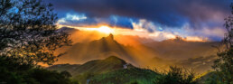
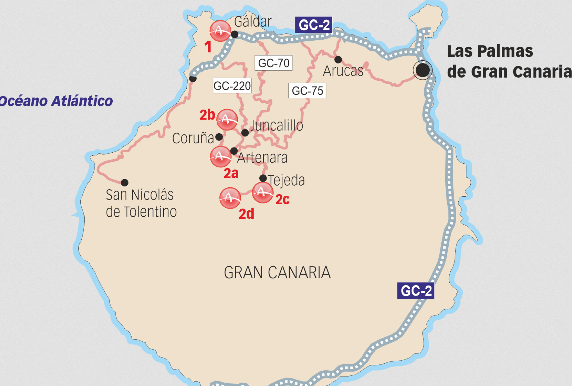
Risco Caído is located in the mountainous heart of Gran Canaria, near the town of Artenara, at an altitude of over 1,200 meters. The protected cultural landscape spans nearly 18,000 hectares, with an additional 8,500-hectare buffer zone. It covers portions of the Caldera de Tejeda, the Tamadaba Natural Park, and the Parque Rural del Nublo, three of the island’s most scenic and biologically rich regions.
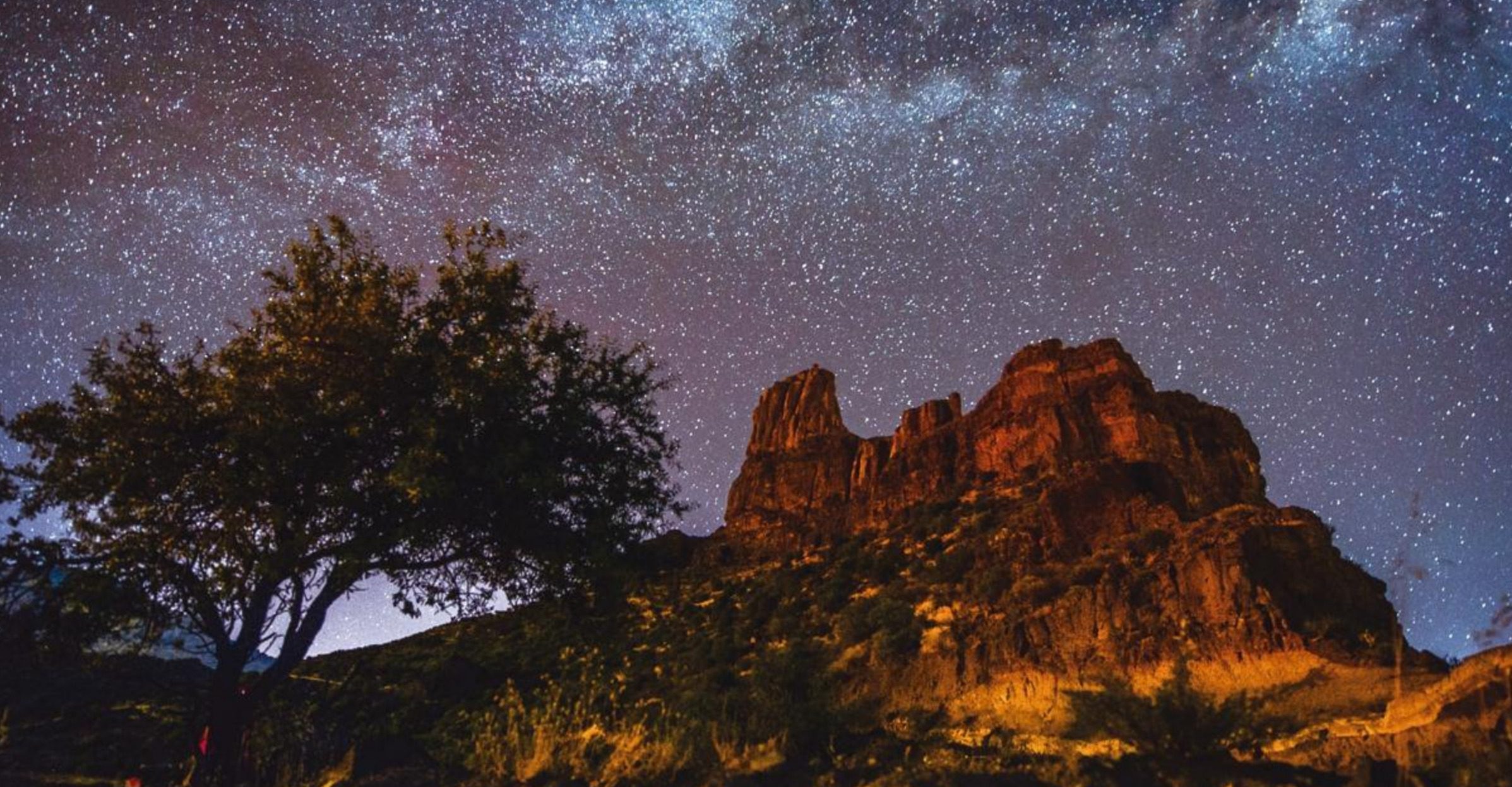
The landscape is a maze of deep ravines, sheer cliffs, volcanic escarpments, and pine-clad slopes. Ancient erosion has sculpted iconic rock formations such as Roque Nublo and Roque Bentayga, which tower over the valleys like stone sentinels. These natural features held sacred significance for the island’s early settlers, serving as landmarks for rituals and agricultural calendars.
The biodiversity of the region is equally impressive. Endemic flora such as the Canarian pine (Pinus canariensis), wild laurels, and juniper thrive alongside native herbs and shrubs used in traditional medicine. Raptors, kestrels, and small mammals make their home here, forming a delicate ecosystem that the ancient inhabitants respected and depended upon.
3. The People: The Canarii and Their Way of Life
The earliest settlers of Gran Canaria, known as the Canarii, were descended from Berber peoples of North Africa. Arriving sometime between the first and fifth centuries AD, they lived in almost complete isolation until the Spanish conquest in the late 15th century. This isolation allowed them to develop a distinct culture that combined African roots with adaptations unique to the island’s challenging volcanic terrain.
The Canarii were primarily farmers and herders. They cultivated cereals such as barley and wheat, used terraced agriculture to trap moisture, and domesticated goats and sheep. They also harvested wild plants, practiced careful water conservation, and built extensive granaries to store food for the dry season.
Their spiritual life revolved around the cycles of nature. Fertility rituals, ancestor worship, and astronomical observations played central roles in their religious practices. The mountains and caves were not just shelters; they were sacred spaces where life, death, and the cosmos were celebrated and interpreted.

4. A Troglodyte Civilization , Living in the Rock
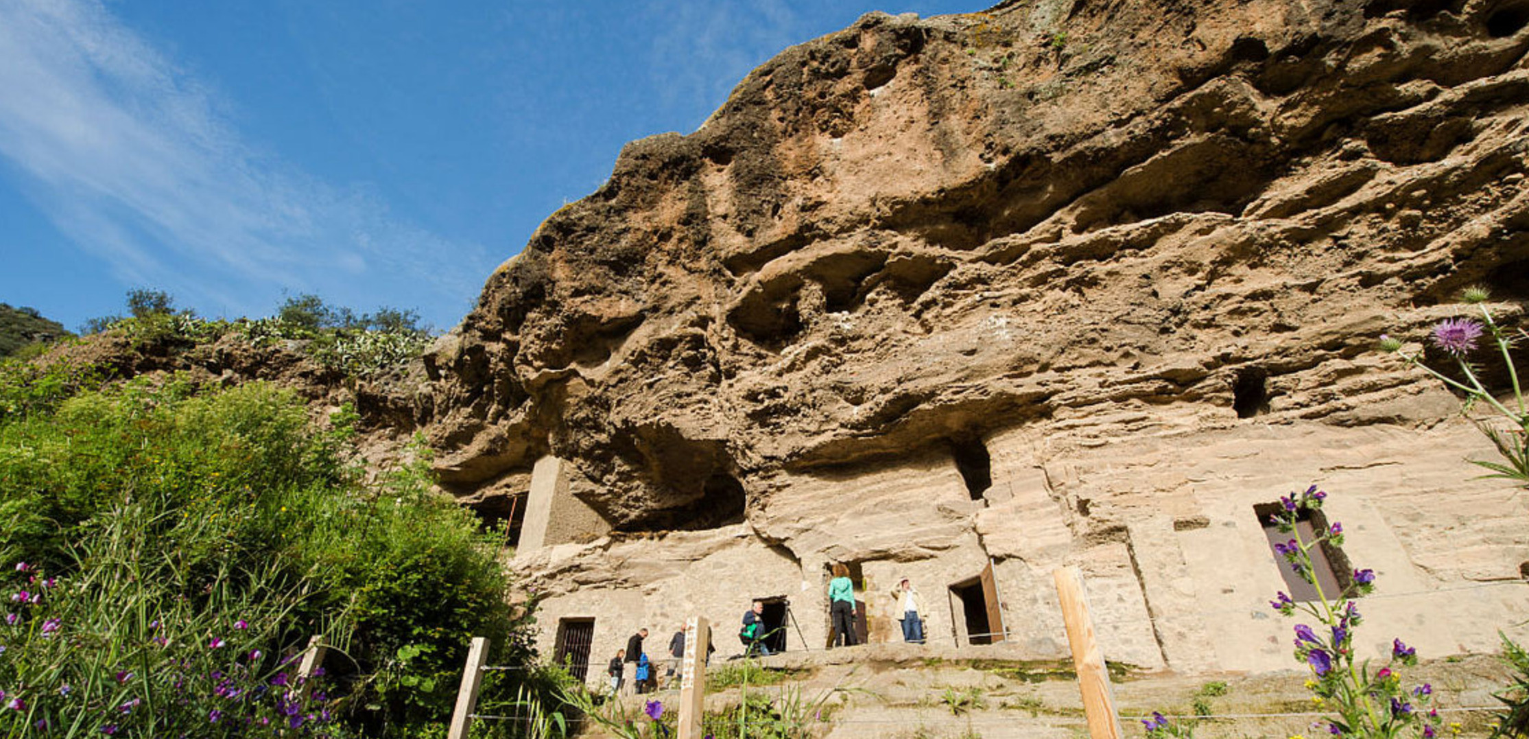
Across the Risco Caído cultural landscape are more than 1,500 caves, both natural and human-made. These served multiple purposes:
• Habitation , Families lived in carved-out cave dwellings, often grouped into communities. These were cool in summer, warm in winter, and easy to defend.
• Granaries and storage , Specially cut chambers were used to store grains, cheese, and other foodstuffs, sealed with stone doors or wooden lids.
• Cisterns , Rainwater collection was essential, and many caves were designed to catch and store water.
• Burial sites , Rock-cut tombs and burial caves, often high on cliff faces, preserved the dead in dry conditions.
• Ritual spaces , Certain caves were clearly ceremonial, decorated with carvings, cup marks, and symbols.
Two of the most important ritual centers in the region are Risco Caído itself (particularly the cave known as C6) and the almogarén (temple) of Roque Bentayga. These were not mere dwellings but sacred places where the Canarii interpreted the will of the gods and the rhythm of the seasons.
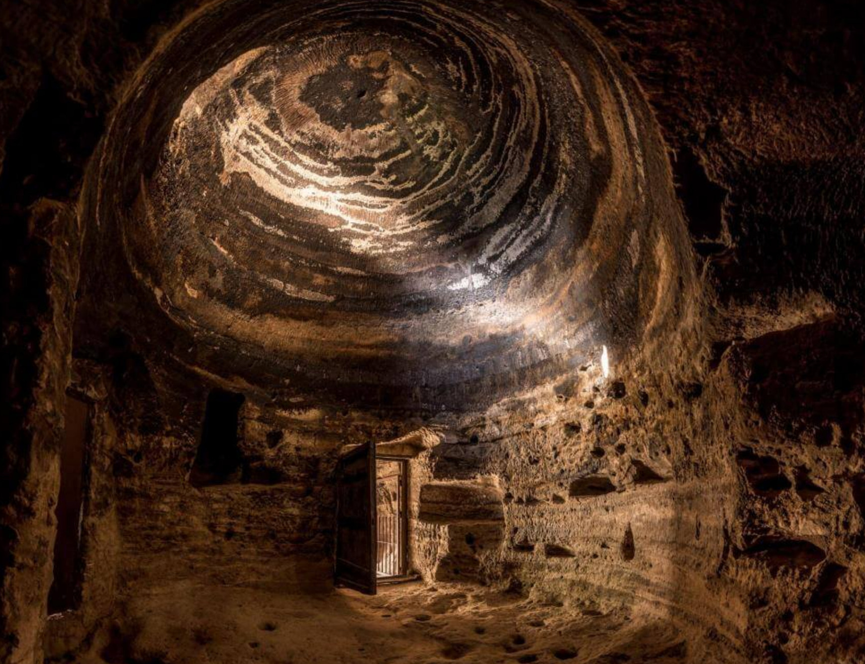
5. The Astronomical Temple , Cave C6 at Risco Caído
The C6 cave is the crown jewel of Risco Caído. This artificial chamber, carved meticulously into volcanic tuff, has a unique parabolic domed ceiling , the only one of its kind in the Canary Islands. Its design was not accidental; it was carefully engineered to interact with sunlight and moonlight.
A small aperture in the roof acts as a solar and lunar projector. Here’s how it works:
• Spring and Autumn Equinoxes , The first ray of sunlight enters through the hole and projects onto the western wall, slowly illuminating the carvings.
• Summer Solstice , The sunlight sweeps fully across the wall, casting sharp light patterns on the engraved symbols.
• Winter Months , Moonlight, particularly from the full moon, takes over the role of marking time, creating similar patterns on the walls.
The wall itself is decorated with triangular and oval carvings, often interpreted as fertility symbols, possibly representing female pubic triangles or male phallic forms. Cup marks, grooves, and other engravings suggest ritual offerings.
This interplay of light and shadow formed a lunisolar calendar, used to regulate planting, harvesting, and possibly ritual festivals. It demonstrates an advanced understanding of the celestial cycles and their connection to agricultural success.
6. Religious and Cultural Significance
For the Canarii, the mountains were sacred. The word “almogarén” refers to ritual sites where priests or shamans conducted ceremonies to honor gods and ancestors. Fertility rites, offerings to deities of rain and sun, and initiation ceremonies likely took place inside caves such as C6.
The Sacred Mountains themselves , Roque Bentayga, Roque Nublo, Mesa de Acusa , were viewed as dwelling places of spirits. High places connected the people with the divine, while caves were seen as wombs of the Earth Mother, symbolizing life, death, and rebirth.
The fact that these rituals were linked to astronomical events underlines the Canarii’s sophisticated worldview. They saw time as a cycle governed by both terrestrial and cosmic forces.
7. Preservation and Modern Interpretation
Because of its fragile condition, the original C6 cave is not open to mass tourism. To protect it, authorities have created a high-tech replica at the Risco Caído Interpretation Centre in Artenara. This replica mimics the cave’s texture, carvings, and the exact light effects of the solstices and equinoxes.
Visitors can experience the light projections as they would have appeared to the Canarii priests, accompanied by detailed exhibitions, audiovisual presentations, and archaeological reconstructions of life in the mountains.
The broader landscape is accessible through hiking trails and guided tours, but conservation remains a priority. UNESCO recognition has increased global awareness, but with that comes the challenge of balancing tourism with preservation.
8. Debates and Academic Controversies
While most archaeologists agree on the cultural and ritual importance of Risco Caído, its astronomical interpretation remains debated. Some scholars argue that:
• The alignment of light could be coincidental or exaggerated without precise measurements.
• There is limited published research confirming exact solstice and lunar correlations.
• Much of the current interpretation relies heavily on the pioneering work of Julio Cuenca, the archaeologist who first identified the light phenomenon.
Nevertheless, the cultural context , fertility symbols, agricultural cycles, and the Canarii’s reverence for celestial forces , strongly supports the idea of intentional design.
9. A Unique Cultural Landscape
Risco Caído is not an isolated site; it is part of a wider cultural landscape where natural features and human activity are inseparably linked. The designation as a “Cultural Landscape” by UNESCO reflects this. The landscape combines:
• Archaeology , The caves, granaries, and ritual sites.
• Agriculture , Ancient terrace farming systems still visible today.
• Natural Heritage , Endemic flora and fauna within protected natural parks.
• Living Culture , Local communities maintain traditions linked to ancient practices, such as seasonal festivals and herbal medicine.
10 Visiting Today , A Journey into the Past
The Interpretation Centre
Start at the Risco Caído Interpretation Centre in Artenara, where you can:
• View the replica cave and witness the light phenomena.
• Study interactive panels, maps, and 3D models.
• Learn about Canarii agricultural and spiritual life.
Hiking and Sacred Mountains
Adventurous visitors can hike trails around Roque Bentayga and Roque Nublo, experiencing the dramatic volcanic scenery that shaped Canarii beliefs.
Best Time to Visit
The highlands are cooler than the coast. Spring (March-May) and autumn (September-November) offer clear skies and comfortable temperatures. However, if you time your visit with an equinox or solstice event, you may witness the same light phenomenon recreated at the Interpretation Centre.
,

MUST SEE Santa Cruz de Mompox 🇨🇴 Colombia
Santa Cruz de Mompox: A Timeless Detour for Salty Souls
For sailors who have danced with the Caribbean winds, dropped anchor beneath Spanish fortresses, and chased the equator’s arc across Colombia’s coastlines, the idea of turning inland might seem counterintuitive. After all, most adventures on the water take place, well, on the water.
But sometimes, it’s worth stepping off the deck and into a different current , a slower, older rhythm that flows not with tides, but with stories. Welcome to Santa Cruz de Mompox, Colombia’s best-kept inland secret and one of the most rewarding side trips you can make from Cartagena or Santa Marta. This is not a port town. It’s a place marooned in time, tethered to the mighty Magdalena River, and glowing with the golden patina of centuries past.
You won’t sail your boat here. But once you visit, you’ll carry it with you long after your hull is back on saltwater. For the cruiser in search of real culture, deep history, and something a little off the gringo trail, Mompox is a detour worth taking.

1. A Sailor’s Reason to Go Ashore ( you could go by dinghy ...)
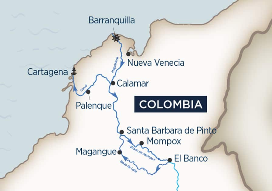
From a nautical perspective, Colombia is already generous: coral-fringed bays, world-class cities like Cartagena, and tropical havens such as the Rosario Islands or Tayrona National Park. So why should a cruising sailor carve out several days to visit a landlocked town three hours up the river delta?
Because Mompox isn’t just another inland destination , it’s a preserved slice of Spanish colonial history, an unspoiled world that skipped industrialization and kept its soul intact. It's the kind of place that reminds you why you started this journey in the first place: for discovery, perspective, and the stories that hide behind headlands.
Unlike coastal towns where tourism has reshaped daily life, Mompox offers something different. It’s lived-in, authentic, a place where nobody is trying to sell you a tour. It’s Colombia with its guard down, its heart wide open. And best of all , it’s still far enough off the radar that you won’t find it overrun.

2. How to Get There (and Where to Leave the Boat)
Getting to Mompox from the coast requires commitment, but it's a well-trodden route for the determined traveler.
• From Cartagena: Leave your vessel in one of the city’s marinas (Club de Pesca, Club Náutico, or Marina Santa Cruz) and arrange a van or bus via Mompox Express or a trusted driver. The journey takes 6–8 hours depending on road conditions.
• From Santa Marta: Also possible with a combination of private car and river ferry. It’s a bit longer, but the road is scenic and remote.
• Best Time to Visit: November through March offers the driest conditions and most navigable roads. Avoid peak Semana Santa unless you're going specifically for the religious processions.
You won’t miss the sea , because the town sits beside a broad tributary of the Magdalena River and has its own waterfront magic. It's just freshwater, not brine.

3. Mompox Is Magic, Not a Museum
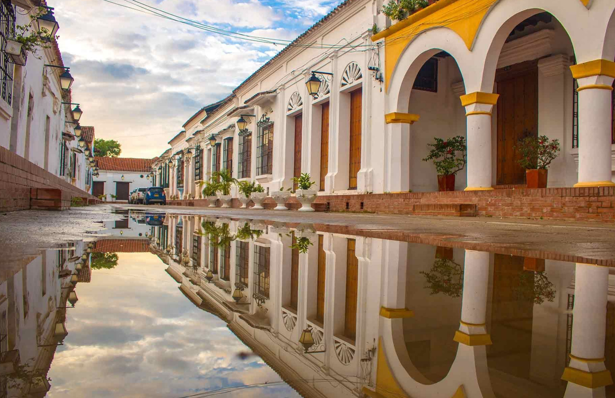
Walk into the heart of Mompox, and time slackens like a sail in dead air. There are no cruise ship terminals, no international chains, and no traffic lights. Horses still outnumber motorbikes on some streets, and iron balconies hang from whitewashed walls like lace.
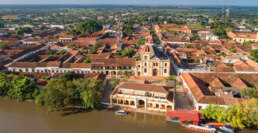
Founded in 1537, Mompox once rivaled Cartagena in importance. It was a safe inland storehouse for gold and trade during the colonial era, but as the Magdalena’s flow shifted and transport routes changed, the town was bypassed , left out of the modern world. That abandonment became a blessing.
Unlike many colonial cities that were modernized, Mompox was preserved. Today, it’s a UNESCO World Heritage Site, one of the most authentic colonial towns in Latin America, with six major churches, a dreamy riverside malecón, and a plaza where little seems to have changed in 300 years.
But Mompox isn’t fossilized. People live here, celebrate, grieve, gossip, flirt, and fall in love here. You won’t walk through it like a museum , you’ll feel like you’ve wandered into a living novel.

4. Highlights for Cruisers Ashore
Even if your legs are still swaying from the last passage, Mompox will ground you. Here are some experiences that make the trip worthwhile:
a) The Riverside Walk at Sunset
Start at the old ferry dock and wander along the river. The light softens over the water, children play soccer in dusty alleys, and vendors sell fried snacks and tamarind juice under ancient trees. It’s serenity served slow, with just the right amount of edge.
b) Iglesia Santa Bárbara
This ochre-colored church is Mompox’s icon, with its unique Moorish bell tower and baroque altarpiece. Built in 1613, it's still in use today and anchors the town’s spiritual identity.
c) Filigree Workshops
Mompox is world-renowned for its intricate gold and silver filigree jewelry, crafted by hand using centuries-old methods. Visit a working taller (workshop) and you’ll see artisans spinning metal into spiders, leaves, and sacred hearts, often barefoot and humming vallenato ballads.
d) Cemetery of Mompox
Far from gloomy, this whitewashed cemetery is poetic and peaceful. Tombstones here tell stories of explorers, poets, and revolutionaries. The silence, broken only by birds, is contemplative , a sailor's place to pause.
e) Colonial Mansions Turned Boutique Stays
Stay at a 17th-century house turned into a boutique inn like Casa Amarilla or Portal de la Marquesa, where tiled courtyards and hammocks whisper stories of conquistadors and revolutionaries.
 5. A Revolutionary Pulse
Few visitors realize that Mompox played a critical role in Latin American independence. In fact, it was one of the first towns to declare total independence from Spain, on August 6, 1810 , six months before Cartagena.
Simón Bolívar, the Liberator himself, famously said, “If to Caracas I owe my life, then to Mompox I owe my glory.” He recruited hundreds of Mompoxanos to join his campaign to free Venezuela. That fiery spirit still simmers under the town’s quiet surface.
For history lovers, the Casa de los Apóstoles and local museums paint a rich picture of this revolutionary legacy. But even without visiting a single exhibit, you’ll feel it in the air , Mompox is proud, dignified, and just a little defiant.
6. For the Culture-Hungry
This is a town that sings. Literally. Music spills from courtyards, bars, and riverboats at all hours. Traditional vallenato , with its accordion-led heartache and bravado , still reigns, though cumbia, porro, and Afro-Colombian rhythms also ripple through the streets.
Cultural festivals abound:
• Semana Santa (Holy Week): One of the most elaborate and haunting in Latin America, with candlelit processions, centuries-old rituals, and intense emotion.
• Jazz Festival (October): An unexpected surprise , international jazz musicians converge in Mompox, blending improvisation with history in candlelit plazas.
• Fiesta de la Virgen del Carmen (July): A maritime-flavored celebration where riverboats are adorned like floats and the faithful set firecrackers on the water.
These aren’t tourist acts , they’re lifelines of local culture. Pull up a chair and you’ll likely be handed an aguardiente and pulled into a dance.

7. A Place for Reflection
After days at sea, your brain adjusts to wind, horizon, and motion. Coming inland, things slow differently. In Mompox, there’s time to reflect , not because you must, but because the town invites it.
Sit by the river at night and watch the moon flicker on the current. Listen to the hum of frogs and diesel panga engines in the distance. Here, you're not measuring anchor chain or barometer drops. You're watching the world unfold like smoke.
Mompox is one of the rare places where you remember that travel isn’t just about movement. It’s about meaning. And the farther you get from the coast, the closer you sometimes get to yourself.
8. Return to the Sea, Changed
There’s a moment every cruiser knows: standing on land, looking back toward the water, knowing you’re headed home , to your boat, your element, your moving house on the sea. After Mompox, that return is bittersweet. You’re rested. You’ve breathed deeper. You’ve remembered something.
The sea will still be there , your anchorages, your vessel in the marina attached with docklines, your sails. Take the detour. Mompox is waiting