

POSSE PERK Benefit from the latest information and Free Seminars on destinations
POSSE PERK:
Benefit From the Latest Information and Free Seminars on Destinations

THE KICK OFF EVENT IN BARRA DE NAVIDAD IS THIS WEEKEND. PARTICIPANTS ARE BENEFITTING FROM A HOST OF SEMINARS TO CHOOSE FROM.
For cruisers that are unable to attend the kick off event, there are virtual opportunities to learn from other webinars available this week from the Tropical Analysis and Forecast Branch of the National Hurricane Center and National Weather Service in Miami, Florida, USA
Please join us next week for a pair of webinars on Forecast Products and Services provided by the National Weather Service's Ocean Prediction Center and Tropical Analysis and Forecast Branch. The webinars will be held Thursday, December 12th, and Friday, December 13th, at 1pm EDT.
For Atlantic forecasts N of 31N (30N in the Eastern Pacific):
Please register for Blue Water Mariners - OPC Products and Services on Dec 12, 2024 1:00 PM EST at:
https://attendee.gotowebinar.com/register/6899628322383892311
For S of 31N / 30N:
Please register for Blue Water Mariners - TAFB Products and Services on Dec 13, 2024 1:00 PM EST at:
https://attendee.gotowebinar.com/register/6374980956027722073

LET THE SEASON BEGIN
LET THE SEASON BEGIN
Hurricane season is officially over in the Atlantic and people are getting underway and moving

After quite a bit preparation Kosmos, 2006 Nordhavn 43, with crew Christi, Eric, and Keith underway from San Diego to Marina Coral in Ensenada. Planning to get to Panama in a month or so. Our next journey begins! Tracker on.
Keith simple sentiment is he is “excited”. I am reflective how special and rare it is to pull off living on a cruising boat, it offers such a wider range of emotions than land life. I am also ready to use the various upgrades to Kosmos to hopefully keep us safe and comfortable.

SY KOSMOS 🇺🇸 Eric, Christi, & Keith - Nordhavn 43'


LA PAZ, MEXICO RESOURCE GUIDE
LA PAZ, MEXICO RESOURCE GUIDE
FROM THE CRUISERS HUB AT CLUB CRUCEROS

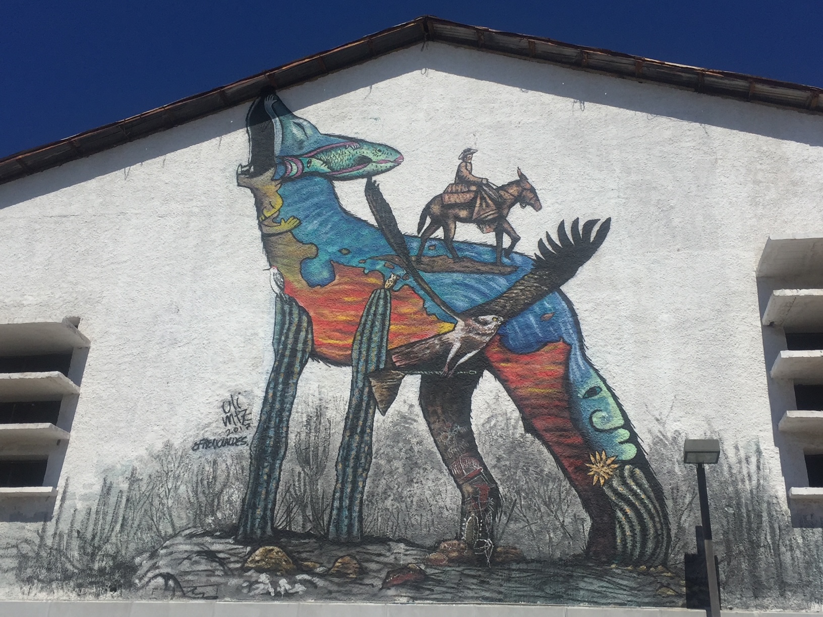
La Paz, the capital of Baja California Sur, is a major stop for cruisers and a gateway to the Sea of Cortez. About 50 nautical miles from Bahía de Los Muertos, La Paz offers several marinas, boatyards, and provisioning options. The city is known for its vibrant culture, murals big and small, great restaurants, and long Malecon (waterfront promenade). There are numerous anchorages around La Paz, such as Bahía Falsa and El Mogote, but the currents can be tricky, so mariners need to be careful. The anchorage in La Paz proper is noted by many to have what people call, "the La Paz Waltz" because the boats seem to dance around their anchor and one another throughout the day.
Ashore, cruisers find a welcome dinghy dock and cruisers hub at Marina La Paz. The cruisers hub is called Club Cruceros. The club hosts morning coffee, tends a 'give and take' library, and most notably, maintains a La Paz Cruisers Guide. This guide is kept up to date by resident long time cruisers. For all mariners planning a stop in La Paz, this resource is free and available in pdf form here: https://www.clubcruceros.net/Cruiser_Guide.pdf?

Using this guide, the city is made very accessible.
The art and murals throughout the city add to the beauty and whimsy of the visit.


MUST SEE ISLA ISABEL NATIONAL PARK MEXICO
MUST SEE: ISLA ISABEL NATIONAL PARK, MEXICO 🇲🇽

Isla Isabel National Park is a Mexican national park and protected area located off the coast of Nayarit southwest of Mazatlan. This isolated island was one Jacques Cousteau’s favorite places and Cousteau himself made the recommendation to the Mexican government to designate this island as a National Park. He spent a great deal of time here and has aired many specials on this fabulous gem. The Undersea World of Jacques Cousteau aired in 1975.
Isla Isabel is one of the main nesting islands for seabirds in the Pacific, including large colonies of Magnificent Frigate birds over 11,000 Fregata magnificens , Blue-footed Boobies Sula nebouxii, Brown Boobies Sula leucogaster and Sooty Terns Sterna fuscata. Marine life is rich, with over 24 shark and ray species, three species of sea turtles, the California Sea Lion Zalophus californianus, Humpback Whale Megaptera novaeangliae and Killer Whale Orcinus orca.
The island is uninhabited by humans, though there is a seabird reproductive research program run by UNAM and tourists visit to camp, fish and bird watch. After having depleted a huge colony of Sooty Terns, which in 1978 had over 150,000 pairs, cats were finally eradicated from the island in 1995 and the Terns are slowly recovering. The biodiversity and migratory populations of animals that live and return here year after year is a stunning MUST SEE.


SEASON 8 AWARD ENTRIES: BIGGEST FISH CAUGHT
SEASON 8 AWARD ENTRIES: BIGGEST FISH CAUGHT

It was a blast. Tuna steaks forever. Vacuum packed and in the freezer. We weighed it with a luggage scale.

SV MALAIKA 🇺🇸 Robert & BettiAnn – Outbound 46′

TURNING WASTE INTO OPPORTUNITY AT FINCA HAMBURGO CHIAPAS, MEXICO
TURNING WASTE INTO OPPORTUNITY
FINCA HAMBURGO, CHIAPAS, MEXICO

Re-Creativa Sustentable Finca Hamburgo
At Re-Creativa, we are more than just a recycling project—we are a community of six women from Finca Hamburgo, deeply committed to turning waste into opportunity. What started as a simple idea has grown into a powerful initiative where we transform plastic waste into beautiful, functional products. Not only are we making a positive impact on the environment, but we are also creating economic opportunities for ourselves and other women in rural communities, right here in the heart of Chiapas, Mexico.

Our Journey to Sustainability
Living in the lush mountains of Chiapas, surrounded by breathtaking natural beauty, we’ve seen firsthand the challenges posed by plastic waste. There is little infrastructure here for waste management, and much of the plastic ends up in rivers or lands in open dumps, damaging our environment. We knew something had to change.
That’s when we teamed up with In Mocean and Finca Hamburgo, our home. Finca Hamburgo is a historic coffee farm in the heart of Chiapas, and it became the perfect foundation for us to build something meaningful. Together, we began the journey to create a space where we could recycle plastic waste and turn it into useful, sell'able products—helping the planet and creating opportunities for our community.

Transforming Plastic into Creativity
It all started with a workshop. Nike, a passionate sailor and founder of In Mocean, reached out to us and offered to lead an introductory workshop at Finca Hamburgo. We invited women and children from the community to join, and together we learned how to make simple drafts from shredded plastic. Over two days, the idea of Re-Creativa started to take shape. We realized we could turn plastic waste into something more—something creative, useful, and impactful.
From that moment on, we knew we had to build something lasting: a community-led recycling workspace where we could create, learn, and contribute to a cleaner, greener future.

Setting Up Our Workspace
With support from In Mocean, the REESE Gruppe, and generous donors, we received the equipment we needed—machines like a shredder and an extruder. Just two weeks after our first workshop, Nike and Maria (co-founder of In Mocean) returned to Finca Hamburgo, and we got to work. We learned how to operate the machines, sort plastics, and use our creativity to make products that would not only help the environment but also generate income.
Our first creations were colorful earrings made from shredded plastic. We quickly began to experiment, crafting bowls and beams using the extruder. But it wasn’t just about making things—it was about learning how to run our new workspace as a small business. We discussed how to generate income, market our products, and sustain this new venture for the long term.

Early Successes and Growing Together
As we took ownership of Re-Creativa, we named our workspace and even designed our logo. We set up an Instagram account to showcase our creations, and soon, the sales started rolling in. The money we earned helped support our families and fueled our passion for the project. With each new product, we saw our skills grow, and we began working on a new goal: our first prototype for a chair made from recycled beams.
What makes Re-Creativa so special is the sense of community we’ve built together. We are no longer just recycling plastic—we are creating something bigger than ourselves. The bond we share as we work, learn, and grow together is the heart of this project. We’ve even begun hosting workshops in schools and cultural centers in Tapachula, sharing our journey and encouraging others to join the movement.

A Beacon of Sustainable Change
For us, Re-Creativa is more than just a workspace—it’s a beacon of hope. It shows that even small, simple actions can lead to big changes. By turning waste into valuable products, we’re not only helping the environment, but we’re also creating opportunities, building a sense of community, and inspiring others to act.
As we continue to grow, we are more determined than ever to transform waste into creativity, opportunity, and empowerment. We know that this is just the beginning, and we’re excited to see where this journey takes us.

Join Us for a Recycling Workshop and Visit Finca Hamburgo
We’d love for you to come and visit us at Finca Hamburgo. Experience the beauty of our home and see firsthand the work we’re doing at Re-Creativa. Join us for a hands-on recycling workshop, where you’ll learn how we turn plastic waste into creative, functional products. It’s a chance to connect with our community, see the impact of our work, and be part of the positive change we’re building together.

Different Ways of Eating Raw Fish Across the Oceans
Different Ways of Eating Raw Fish
Across the Oceans
People living coastally or on islands are deeply connected to the ocean for their sustenance. Eating raw fish is common across many cultures around the globe, each with its own unique traditions and methods for preparing and enjoying this delicacy. Here are several different ways raw fish is eaten as a main dish across the Oceans that the Ocean Posse cruises:
1. Ceviche (Latin America)

Ceviche has it’s roots in the northwestern region of South America that are now
known as Ecuador and Peru. Overtime the dish has spread throughout Central America with each country, each region, each family adding their own touch of individuality. Ceviche is the result of fish (often Mahi mahi, snapper, or corvina) and/or other seafood (for example shrimp, conch, or Octopus) being submerged in salt and lime juice. The chemical process that occurs is similar to fish getting ‘cooked’ in which the flesh turns opaque and gets firm…although the fish is not truly cooked.
The additional ingredients, the presentation, the size, and the accompaniments vary greatly depending on where you are. For instance, along the Gold Coast in Mexico ceviche is commonly a mix of fish or mixed seafood with tomatoes, onions, jalapenos, and cilantro served on a large platter with a basket overflowing with various large corn disks called tostados. Further south, in Panama, ceviche is commonly served in small individual servings with diced onions and lots of juice and a small singular packet of crackers. Further south still to Peru, the birthplace of ceviche, raw fish is marinated in lime juice, as well as thinly sliced onion. The dish is served with sweet potato slices, small portions of toasted corn, and plantain chips. They are all DELICIOUS ….just different….and sampling ceviche along the route is highly recommended.
2. Poisson Cru (Polynesian and South Pacific Islands)

The name poisson cru literally translates to "raw fish" in French. For many centuries native Polynesians and people of the South Pacific Islands were harvesting reef fish and pelagic fish and coconuts as a mainstay of their diet. The preparation was once as simple as pouring fresh squeezed coconut milk over raw fish and has evolved to include lime juice after the Europeans introduced citron (limes). Poisson Cru has a distinctive flavor and texture that is generally more mild that ceviche. While it is sometimes compared to ceviche due to the use of raw fish and citrus juice, poisson cru has its own unique preparation and cultural significance. Poisson Cru is often served with or over rice or taro with cucumbers and/or tomatoes. Seasonal and regional twists include adding fruits like mango or papaya or other vegetables like carrots or avocados. Salt and Pepper may be added for flavor.
Poisson Cru is made at home, during celebrations, and often served at communal gatherings or feasts. It is considered a symbol of hospitality and represents a longstanding connection to the sea. The preparation and sharing of poisson cru are deeply embedded in the social fabric of Polynesian life.
Overall, poisson cru is more mild and creamy while ceviche is more tangy and snappy. Both are fresh, crunchy, and scrumptious.
3. Poke (Hawaiian Islands)

The word 'poke' (like 'okay') was a Hawaiian word that meant 'to cut crosswise into pieces'. The dish that has taken on the name Poke is one that stems from one of the staple foods of the early Polynesian people of Hawaii. The early Polynesian people of the Hawaiian Islands lived off the sea. It is said they often cut crosswise and salted raw reef fish cutoffs and seasoned this with seaweed and roasted kokui nuts. Over time, after the arrival of people from the continents to the east and the west, this staple food began to evolve and take on tastes and flavors from both sides of the ocean. For example in the late 19th century many Japanese workers immigrated to Hawaii as sugar and pineapple plantation laborers. Instead of using salt and seaweed to season their raw fish they used shoyu (soy sauce) and sesame oil. They would eat this fish with white rice. In this way, some say that the Japanese immigrants also introduced the rice base to the modern day Poke. Westerners are said to have introduces spices, onions, and chili peppers. Poke of today is a serious fusion of flavor traditions that appeals to the culinary tastes across many cultures. While the dish has evolved greatly and spread far from Hawaii, Poke is still known as an adaptable delicious Hawaiian dish. Poke can be savory and sweet, spicy or mild. The fish is still marinated in a salty medium with seaweed is often served in bowl over rice with an added assortment of fresh, thinly cut colorful vegetables, fruit, and roasted nuts.
4. Pickled Herring (Northern Europe)

Eating raw fish is a global practice, with each culture putting its unique spin on how the fish is prepared, seasoned, and served. Whether marinated in citrus, salted and dried, or simply sliced fresh, raw fish continues to be an essential and cherished part of culinary traditions worldwide.

MANTA RAYS MAJESTIC & MYSTERIOUS
MANTA RAYS : Majestic and Mysterious

Manta Rays are among the most majestic gentle giants in tropical and sub tropical oceans of the world. Seeing them swim under water is a magical sight to behold; with their mouths wide open, manta rays silently move through the water in a slow, effortless, gliding motion, feeding on the smallest of living creatures, plankton, that drift in the ocean currents. Like many species of sharks, mantas are in constant motion to keep water flowing over their gills to breathe. Additionally, mantas are cartilaginous fish meaning their skeleton is made of cartilage like our ears and noses.
There are two species of Manta Rays: the Reef Manta (Mobula alfredi) and the Oceanic Manta (Mobula birostris). No matter the species of manta, With their wings outstretched they dwarf all but large sharks or whales. The reef mantas wings span up to 5 meters while the oceanic mantas wings span up to 7 meters and can weigh up to 2 tons. Manta Rays have the largest brain to body ratio of all living fish and are known to display high levels of intelligence, have long-term memory, and are able to map their environment using sights and smells. The markings on their underside are their unique 'fingerprint'. Much like the marking on the underside of a humpbacks tail, the star-like pattern of whale sharks, and the whisker spots of lions, there are no two exactly alike and these creatures can be identified by their markings that make them unique.

As seen in this photo above there is a mutualism, or mutually beneficial relationship, between mantas and various small hitchhiker fish like remoras. The Remora clings onto the Manta Ray for protection, transportation and scraps from the Manta Rays meals. The Remora benefits the Manta Ray by cleaning it’s skin of bacteria and parasites keeping Mantas healthy. Manta Rays can also be found at 'Cleaning Stations' (or healthy coral patches) sometimes circling close by for up to an hour before moving in for a cleaning and then staying on for hours getting cleaned. In this case the mantas have a symbiotic relationship with cleaner fish (like the cleaner wrasse fish and the scarlet cleaner shrimp). These small fish and crustaceans swim around the larger animals and inside their mouths to eat the parasites, bacteria, and dead skin cells from their bodies. One animal is getting fed while the other is getting cleaned. It's a win-win! Manta Rays will often return to cleaning stations they 'know'.
Manta rays live up to 50 years. The female manta becomes sexually mature a bit later than the male: round 8-10 years of age. Manta rays are ovoviviparous meaning that after fertilization the offspring grows inside an egg (like a bird...but WAIT...there's more)...which the female manta carries inside of her during the pregnancy and give birth to a live fully independent manta ray (live birth like a mammal?!). Mantas give birth to 1-2 manta every 2-5 years. Many details are still a mystery as no one has ever documented seeing a live birth in the wild.

Perhaps because of their size, their grace, their omnipresence in the oceans Manta Rays, and many other characteristics, manta rays have found their way into the art and mythology of many cultures around the world. In Polynesian mythology, for instance, the manta ray is believed to be the guardian of the ocean and a symbol of knowledge and wisdom. In ancient Greek mythology, they were believed to be messengers of the sea god, Poseidon. In ancient Hindu mythology, manta rays are believed to be the manifestation of Lord Vishnu, the creator of the universe. In Japan, manta rays are often associated with the god of the sea, believed to protect sailors and fishermen from danger and provide them good fortune. Interestingly, they are universally seen as protectors and not aggressors, creators not destroyers.
Sadly, as much as manta rays are widely admired to revered their existence is threatened in various ways. Being pelagic, they cross 'borders' constantly and live in a warming ocean that is thereby struggling with habitat loss and teaming with industrialized fishing techniques that do not take care to avoid them (mantas are often 'bycatch' and can die due to suffocation as a result of entanglement.). In some places mantas are specifically sought out for food and bait (for instance in the Sea of Cortez, Mexico) and in the western south Pacific mantas are harvested for their gill plates that are used in Asian Medicine. It is worth noting that in Indonesia, Peru, and the Philippines there now national laws in place to protect manta rays.
Still, in order to protect animals, we need to understand them. Efforts are being made to understand manta distribution, mating, and ecology better to help them. However, Scientific efforts to understand Mantas formally began rather recently around 2008.

According to Mantatrust.org :
Manta rays often undertake seasonal migrations, travelling tens, hundreds, and sometimes thousands of kilometers. This means that their habitat can encompass large areas, sometimes crossing national boundaries, where conservation management is often more challenging. Therefore, to effectively protect these animals, we must first understand what habitats they are using, when they are there, and what they are doing within it.
....It is often a sad fact of human nature that the more endangered a wild animal becomes, the greater our desire to possess or consume it. Diminishing stocks drive a lucrative trade (often illegal) to hunt down, trade in, and consume the dwindling populations of these endangered species.
Interestingly, again there is still so much mystery around mantas that citizen scientists are helping with these efforts. People can communicate directly with the scientists at Manta Trust to help supply information (pictures) to create a 'mantabase' about specific manta individuals to share where they are and begin to help map their health, habitats, and seasonal routes.
If you are a mariner, look out for this incredible species of fish. Maybe you can appreciate their majesty while unlocking some of their mystery.
LATEST RESOLUTION FOR MEXICAN FOREIGN BOAT TIPS FROM PRE-2005
LATEST RESOLUTION FOR
MEXICAN FOREIGN BOAT TIPS FROM PRE-2005
The Ocean Posse is pleased to share information directly from a recent success story. As reported in our October 20, 2024 newsletter there is hope yet for foreign flagged vessels that were issued TIP's (Temporary Import Permits) and are now attempting to enter Mexican waters. Last year all vessels with open TIPs from before 2005 were flat out turned back and refused entry because the office that had issued the TIPs had been dissolved and therefore any TIPS issued by this office that had not been properly closed were not able to be resolved. This year Sally & Michael Aldridge on SV SWEETHEEART took this matter into their own hands with conviction and seem to have found a solution. Sally shares below what worked for them so that others may have similar success.
Oct 17 2024 by Sally and Michael Aldridge on S/V Sweetheart
Canceling pre 2005 Aduana TIPs in Ensenada
We had two pre 2005 TIPs to cancel, one in 2001, and the other in 2004
On Oct 16, we walked across the border at PedEast at San Ysidro in the morning and caught the ABC bus down to Ensenada from Tijuana because we didn’t want to mess with driving a vehicle across the border and dealing with a motor vehicle TIP and insurance (too many TIPs already !) Walking over the border turned out to be super easy, with no lines and the bus is nearby and is comfortable and inexpensive.
When in Ensenada (we got there at around 10:30am) we started with the
Banjercito Ensenada
On Ave Teniente Jose Azueta
(Building marked with a thin red line on attached image)
We spoke to Elia Beatriz Urquidi Cobos, who is a manager there
She speaks great English
We showed her relevant boat documentation as per the attached form from the Mexican consulate in Sacramento.
Elia made 3 copies of each, and also verified and checked the report in her system.
Elia explained we needed to go to the Aduana office down the street to start the process.
At this point Elia stepped outside to direct us and she and the manager of the Aduana, Jorge Badille spoke in person on the street. Not sure if they just “ran into each other” or whether this was planned, but it turned out to be a very fruitful conversation. Jorge reviewed our documents right there, and confirmed that everything was in order, and told Elia what else we needed to do
Which was the following:
Write a letter to the Aduana asking for the TIPs to be cancelled
Including the tip number, previous owner names etc.
State that we are the new owners
Print it
Sign it
Make 3 copies
We went to the tourist information office around the corner to do this and they were very helpful and made print outs and copies for us for free.
Then we went to the Aduana de Ensenada with all the paperwork. The office is marked with thick red line on the image and address is here. Blvd, P.º Olas Altas 110, Recinto Portuario, 22800 Ensenada, B.C., Mexico
This office is behind a heavy layer of security and they told us that only one person can go through, so Michael, my husband, did this for us as he is the appointed “manager” of our LLC. He spoke to the woman at the desk and she asked for the letter to be in Spanish, so she translated it for Michael and he wrote it out by hand and she stamped it. She told him it would take one week to get the TIP cancellations done.
We then showed the stamped letter to Elia back at the Banjercito, but she said she actually needs a printed and stamped image of a “cancellation screen” from Aduana to get the process going on the Banjercito side. She said once she has that, she can send it to the Mexico City Banjercito and it could be canceled out of the system intraday, depending on time differences.
So we went back to Jorge at the Aduana to ask for that and he committed to doing just that the next day. Jorge promised to email it to Elia it at 10am the next morning, so we stayed overnight just to make sure that happened.
We stayed at the Hotel Coral, as it was a good chance to speak with Fito Espinoza, the dock master, who is very experienced with TIPs and immigration. He suggested we stay on it till it is done. He was very interested to hear about the results of our efforts as it will allow him to help many other boats.
Michael went back to the Aduana office the next day at 10am on 10/17 and he stayed there until he had the right docs in hand.
At this point we have now cancelled the two old TIPs !
We then took those pages to Elia who scanned them and sent them to her superiors. The old tips were cleared out of the Banjercito system within a few hours and we were able to successfully apply for a new TIP that day. Again we sat in the office until this was all done (about 30 mins) and we now have the TIP in hand.
Summary: The Sacramento consulate was correct: It is now possible to cancel pre 2005 TIPs with the Aduana in Ensenada, and the Banjercito in Ensenada can get it cleared from their system with the right documentation from Aduana (see attached process from the Mexican consulate in Sacramento). Fito confirmed this is exactly how the process worked in the past, but he did not know it was working again at this time, and neither did BC Connections.
Jorge (Aduana Ensenada manager) and Elia (Banjercito Ensenada manager) are competent people who seem to have a good working relationship and they are collaborating together to make it happen. It helps that these offices are down the street from each other. Not sure if it’s dumb luck and they have started canceling old TIPs again at just the right time for us, or we are geniuses. Either way, we will take it !
There are no charges for the process of TIP cancellation and it can be done by the boat owner through the official channels without an agent in one or two days. Be prepared for multiple visits to each office.
Hopefully this bodes well for other boats in this situation.
Feel free to send any questions to sally.aldridge@mac.com
THANK YOU SV SWEETHEART FOR SHARING YOUR SUCCESS!


ROOTS OF THE DAY OF THE DEAD TODAY
ROOTS OF THE DIA DE LOS MUERTOS:
DAY OF THE DEAD CELEBRATION TODAY

Dia de Los Muertos or Day of the Dead is a Mexican holiday celebrated throughout Mexico (particularly in Central and Southern Mexico) over a two day period: November 1st (Dia de los Angelitos dedicated to deceased children) and 2nd (Dia de los Muertos dedicated to deceased adults). Today, Dia day Los Muertos is celebrated by people of Mexican heritage elsewhere throughout the world as well. The multi-day holiday involves family and friends gathering to pray for, remember, and honor friends and family members who have died. Today, traditions connected with the holiday include building altars called ofrendas. Oferendas are build in people's homes or in public spaces. During this time people also visit cemeteries to clean the gravesite or headstone of a deceased loved one and decorate their grave with gifts such as calaveras (skulls), calacas (skulls), strings of marigolds, the favorite foods and beverages of the departed. Visitors also leave possessions of the deceased at the graves. In some regions there are parades and women dress as Catrinas in lavish gowns, their faces painted. The parades include music and performance dancing. Today, Dia De Los Muertos is a time for those in the mortal realm to help support the spiritual journey of the dead. In Mexican culture, death is viewed as a natural part of the human cycle. Mexicans view this holiday not as a day of sadness, but as a day of celebration.

The Dia De Los Muertos holiday of today is a product of the different faiths and traditions of both indigenous people of Mexico (dating back thousands of years), Roman Catholicisim (dating back hundreds of years), and modern culture mixing over time. In the case of celebrating life and death in today's Dia de los Muertos, the roots of these indigenous and traditional beliefs go back thousands of years to indigenous Aztec people of what is now central and southern Mexico. The Aztecs did not see death as the end of one's existence, rather, another stage of one's life. One can not live without death and one cannot die without living. It is thought that they believed that the realm of the living world, the divine, and the spirit world all exist. Originally, Día de los Muertos was the entire ninth month of the Aztec calendar. The Aztecs dedicated the month to honoring both the people that would reincarnate as well as the god that allowed humans to reincarnate. In particular, they honored the god Mictlantecuhtli. The festivities celebrating it were known as Miccailhuitontli or Huey Micailhuitl, which translates to ‘The Great Feast of the Dead’.

According to the Great Nahuatl Dictionary, Mictlán means underworld. Others translate MICTLÁN as “place of the dead.” Different legends, visual representations and ancient codices define Mictlán as an unknown, dangerous and dark place, which has nine levels. In this worldview, the Earth was considered a being that devoured the flesh of the deceased. At the time of death, the deceased was thought to be paying off their debt with the Earth, since when they died, they gave continuity to the cycle of the universe. These nine levels are related to rot, fetid, cold, damp, watery, darkness, and night. The animals related to the Mictlán were owls, bats, worms and centipedes, which were in the service of Mictlantecuhtli and his consort Mictecacíhuatl.
The Nine Levels:
1. Itzcuintlan
Place of the dogs
2. Tepectli monamictlan
Place of the hills that come together
3. Iztepetl
Hills of the very sharp flints
4. Itzehecayan
Place of the obsidian wind
5. Paniecatacoyan
Place where people fly like flags
6. Timiminaloayan
Place where people are smitten
7. Teocoyohuehualoyan
Where the jaguars eat your heart
8. Izmictlan Apochcalolca
Smoke water lagoon
9. Chicunamictla
The nine waters.

Death was seen in the underworld of the Aztec world view where much transpires. Over thousands of years this worldview has maintained life in the spirituality if indigenous people of Mexico. 500 years ago, when the Spanish empire colonized what is now Mexico they brought with them Catholicism and made a devout effort to introduce and convert indigenous people to this faith and view of the world. Churches were built and people were brought into the Catholic religion. Catholicism celebrates All Saints’ Day (November 1) and All Souls’ Day (November 2), both of which also commemorate those who have passed. These celebrations commemorating those that have passed is an area in which the Catholic faith and the indigenous faith found common ground. It's a syncretism, where indigenous religious practices have merged with the Christian belief systems introduced, or opposed, by the Spanish during the colonial era. There are actually many examples of syncretism throughout Mexico, most notably found at the main church in San Juan de Chamula in Chiapas. While the details and beliefs around death and the afterlife diverge greatly the people of Mexico today have a celebration in Dia de los Muertos that has roots spanning thousands of years of indigenous spirituality, hundreds of years or Catholic religious influence, and the modern constant of cultural expression.


