
CRUISING ° FLEET UPDATE & NEWS ° 2025-06-22
“If we were meant to stay in one place, we would have roots instead of feet.”
⛵CRUISING ° FLEET UPDATE & NEWS 2025-06-22
-
Pictures Of The Week 📸
-
The Great White Wall 🤿 Taveuni
-
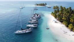
Pier 41 Marina 🇧🇲 Bermuda
-
R.I.P. Domingo 🇵🇦 Bahia Honda
-
2 Stroke Outboards 🪸 vs coral
-
Ocean Posse BBQ Meet Up Tahiti🔥
-
Venerable Goiot 🛠️ Escape Hatches
-
Suwarrow Cook 🇨🇰 Islands
-
Tom Neale 🏝️ An Island to Oneself
-
Uninvited Visitors 👽
-
Named Winds in the Mediterranean 🌬️Meltemi
-
Sunken City Of Epidaurus 🏺 Ancient Theater
-
Meet The Fleet 🇨🇦 SY Gargoyle II
-
Ocean Posse 📅 Events
-
Scarbourhgh Marina 🇦🇺 Brisabne
-
Ocean Posse 🛰️ Fleet Tracking
-
💬 Tidbits
- Balboa Yacht Club Slides into the Water
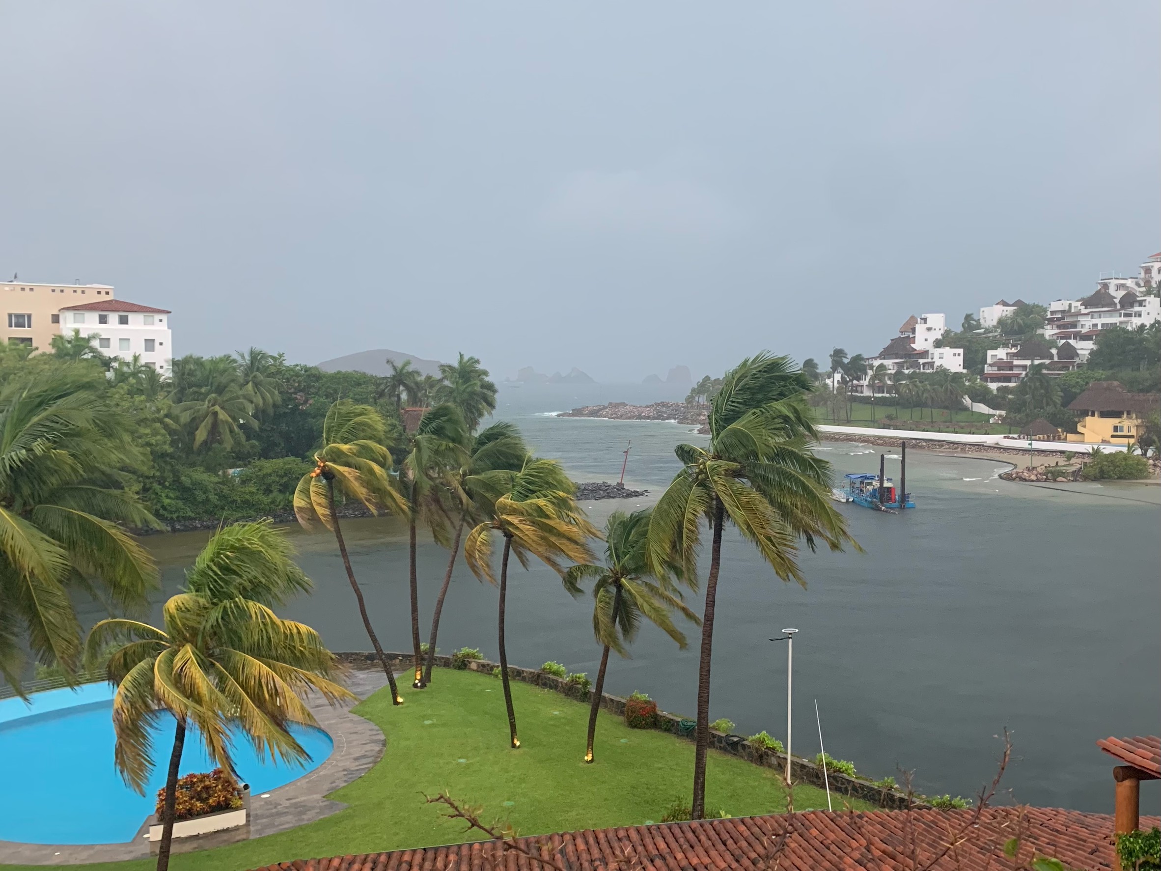
- Ixtapa Rainfall Post Hurricane
- 2025 Bahamas Cruising Fees
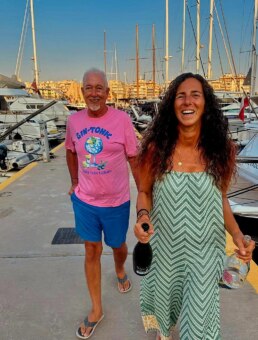
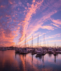
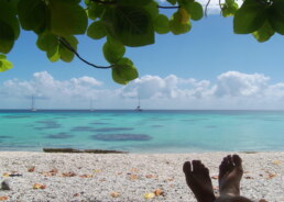
PICTURES OF THE WEEK
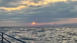
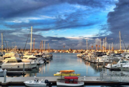
Sunset at sailors return restaurant after Father’s Day dinner. Sunset Marina, Stuart, Fl.
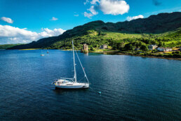
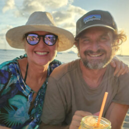
SY DAWN PATROL  Laney & Mark – Outbound 46′

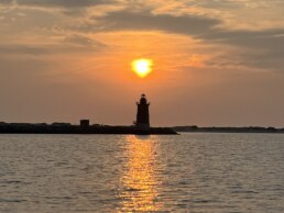
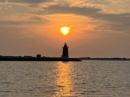
Sunrise over the Delaware Breakwater Lighthouse, off Cape Henlopen
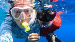
SY PERCEPTION Jim & Melinda – Lagoon 42′

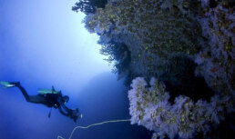
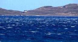
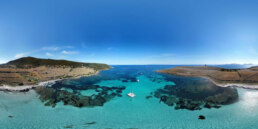
THE GREAT WHITE WALL 🤿 TAVEUNI 🇫🇯 FIJI

FIJI’S SOFT CORAL CATHEDRAL
Taveuni, Fiji’s third-largest island, is often referred to as “The Garden Island”, a name earned by its rich volcanic soil and lush tropical vegetation. Located in the remote northern Lau group and part of the Vanua Levu archipelago, Taveuni stands apart in both topography and culture. It’s one of the few islands where the International Date Line crosses land, yet life here moves with tides and trade winds rather than clocks. For sailors navigating the South Pacific, Taveuni is a remote refuge of natural beauty, cultural depth, and world-class diving.

The island is roughly 36 long and 22nm wide. Its spine is dominated by a volcanic ridge, with Mount Uluigalau, rising to 4000 feet at the highest point. From the deck of a yacht approaching from Somosomo Strait, Taveuni presents a wild, jagged green line, rising steeply from the sea—its interior cloaked in cloud forest, waterfalls, and agricultural terraces.
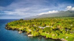
But Taveuni’s most famous treasure lies beneath the water.
Just off its southeastern shores, in the Somosomo Strait between Taveuni and Vanua Levu, lies one of the greatest dive sites in the world: The Great White Wall.
Arrival by Sea: Sailing to Taveuni
Approaching Taveuni from the south or east requires careful navigation. The waters surrounding the island, while mostly well-charted, are full of submerged coral heads and strong tidal flows, particularly in the Somosomo Strait. Most cruisers access Taveuni from Savusavu or Viani Bay on Vanua Levu and time their crossings for slack tide.
There are several anchorages around Taveuni, but few proper marinas. Most yachts drop the hook off Matei, near the northern end of the island, or venture further south where moorings available and is a cruiser-friendly base for dive excursions.
There are sudden shelf drop-offs that characterize the region. Depth sounders can go from reading 100 feet to 1200 feet in the blink of an eye. That same topography, however, is what creates the rich marine life that makes the region famous.
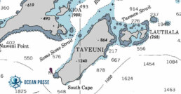
The Somosomo Strait is a narrow body of water that separates Taveuni from the southeast coast of Vanua Levu. It’s a nutrient superhighway—where cold, plankton-rich upwellings from the deep ocean get funneled into shallower reef systems.
For divers, this means an abundance of soft corals, pelagics, macro life, and dramatic visibility shifts depending on tides. At slack tide, visibility can reach 40 meters; at other times, the current rips through so fiercely that dive operators only allow drift dives. But the rewards are staggering.
Most of Fiji’s iconic dive sites are located within or near the strait. These include Rainbow Reef, The Purple Wall, Annie’s Bommie, and of course, the crown jewel: The Great White Wall.
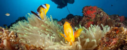
The Corals
Contrary to what many assume, the corals aren’t bleached. They are alive and thriving, colored white due to their unique pigmentation, which reflects ambient light in a ghostly hue. When the current flows just right—often during incoming tide—the polyps open and extend like translucent flowers, catching passing plankton.
Alongside the white corals, a supporting cast of neon-colored soft corals—lavender, magenta, fire-red, golden-yellow—dot the ledges and crevices. The biodiversity rivals any reef system on Earth, including Raja Ampat or the Red Sea.
The Marine Life
Beyond the corals, the Wall is also home to:
• Blue ribbon eels slinking from holes in the reef
• Lionfish hovering in the shadows
• Schools of fusiliers glinting like mercury in the light
• Gray reef sharks circling just out of reach
• Giant trevally hunting in packs
• Sea turtles cruising calmly by
Macro lovers will find nudibranchs, leaf scorpionfish, pipefish, and the occasional ghost pipefish hiding in the flowy coral branches.
It is this interplay of soft coral spectacle, underwater topography, and pelagic life that makes the Great White Wall one of the top dive sites in the world.

Best Season to go
• May through October (the dry season) is ideal, with cooler water temperatures (26°C to 28°C) and better visibility.
• November through April is wetter and cyclone-prone, but marine life remains vibrant.
Most divers do the wall twice: once during low tide and again at high tide, to witness how different currents affect coral expression and visibility. Slack tide offers the best conditions for photography.
Dive depths range from 15 to 35 meters. Advanced Open Water certification is recommended, though experienced operators will guide intermediate divers with care.

SAU BAY RESORT SPONSORS THE OCEAN POSSE
SAU BAY RESORT & SPA – MOORINGS AND DIVE CENTER 🇫🇯 SPONSORS THE OCEAN POSSE

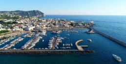
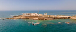
PIER 41 MARINA  BERMUDA
SPONSORS THE OCEAN POSSE
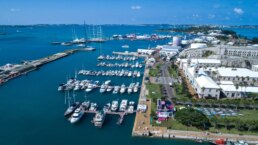
32° 19.47′ N 064° 50.03′ W
We are pleased to sponsor the Ocean Posse and offer a 10 % discount off our short term rates*
Willy
TEL: (441) 705-4141 or 543-4141
EMAIL: info@pier41.bm
DOCKMASTER: dockmaster@pier41.bm
Radio Call: PIER 41 MARINA Channel 16
Address: Freeport Dr, Bermuda
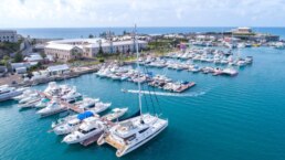
SERVICES
- BERTHS up to 120′
- 100 breakwater protected slip
- Electricity
- 150′ Fuel Dock
- Potable Water
- Line crew services
- Dockshop
- Chandlery
- Minimart
AMENITIES
- WIFI
- Secured Gate Access
- Private Restrooms
- Clean Showers
- Laundry
- Hospitality options
- Restaurants
- Shopping
- Accommodations
- Transport
- Historical Sites
- Beaches
NEARBY
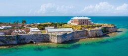
1. Royal Naval Dockyard
📍 32°19’29.3″N 64°50’04.6″W
Why visit:
Once the strategic stronghold of the British Royal Navy, the Dockyard has been restored into a lively hub with museums, shops, and shipyard remnants. The National Museum of Bermuda, located within the Keep, showcases maritime history, shipwrecks, and colonial defense systems.
Highlight: The Commissioner’s House with panoramic views and rare maritime exhibits.
2. St. George’s Town & Fortifications (UNESCO World Heritage Site)
📍 32°22’49.3″N 64°40’57.5″W
Founded in 1612, this is the oldest continuously inhabited English town in the New World. Cobbled alleys, historic churches, and colonial buildings remain intact. Surrounding forts like Fort St. Catherine offer sweeping ocean views and insights into British coastal defense strategies.
Highlight: The re-enacted dunking of the town gossip in King’s Square.
3. Gibb’s Hill Lighthouse
📍 32°15’10.1″N 64°50’05.0″W
Built in 1846, it’s one of the oldest cast-iron lighthouses in the world. Sailors relied on its light to navigate Bermuda’s treacherous reefs.
Highlight: Climb 185 steps for one of the best panoramic views of Bermuda and the reefline.
4. Crystal & Fantasy Caves
📍32°20’58.3″N 64°42’48.5″W
Discovered in 1907, these subterranean marvels feature dramatic stalactites and clear blue pools. While not nautical in nature, they reflect Bermuda’s unique geological and hydrological makeup.
Highlight: Floating pathways suspended above glass-like waters.
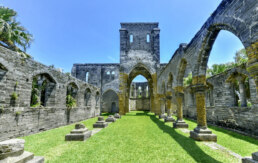
5. The Unfinished Church
📍32°23’01.2″N 64°40’35.5″W
An evocative gothic ruin near St. George’s, left incomplete after multiple construction halts. It has become a symbolic site representing Bermuda’s colonial ambition and religious history.
Highlight: A quiet, photogenic detour on the way to Tobacco Bay.
R.I.P. DOMINGO – BAHIA HONDA 🇵🇦 PANAMA
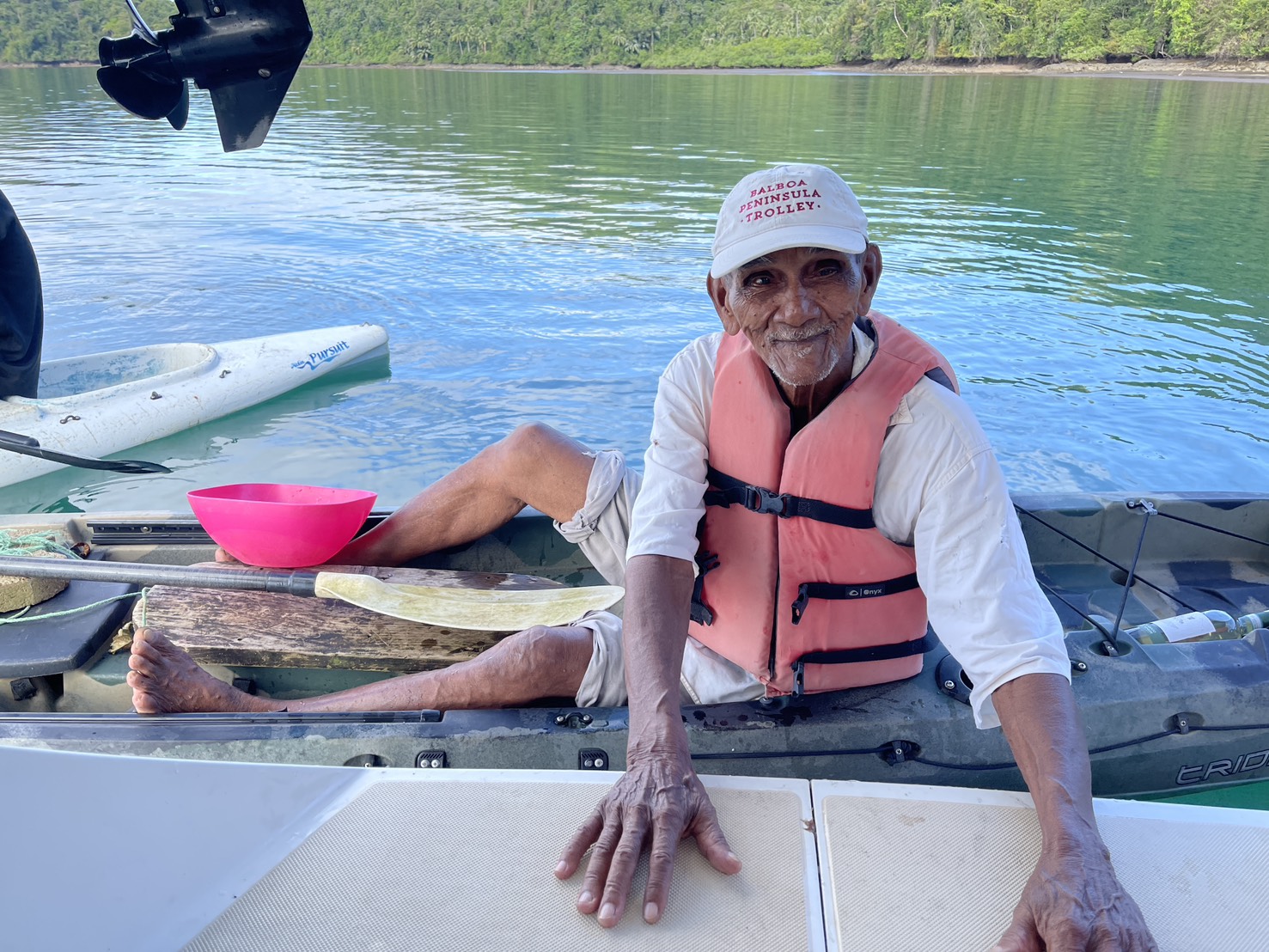
In Memory of Domingo of Bahia Honda
Many of us who passed through Bahia Honda remember Domingo. An old soul with a kind heart, Domingo was always out there in his panga and with quiet strength and a watchful eye.
He was more than a local. Domingo was the first to wave, the first to greet new cruisers dropping anchor. Whether offering fruits, making pizza, or helping vessels, or just floating nearby with a smile and a few words of welcome, he became part of the arrival experience. He brought a human warmth to an already beautiful anchorage.
May the sea carry him gently.
Fair winds, Domingo.
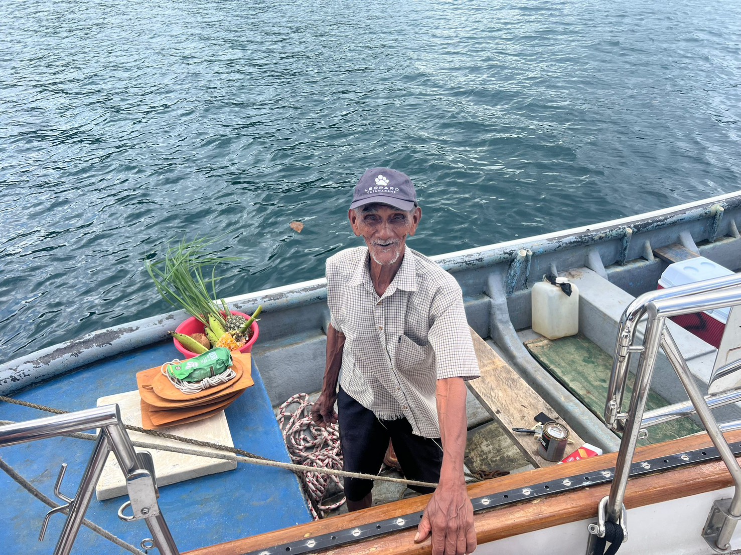


07° 45.7460′ N 81° 31.8120′ W
Bahia Honda is on the west side of the Azuero Peninsula – a wide and very sheltered bayHe always brought us fruits and greens from their property The anchorage is super calm, surrounded by green hills and mountains. It’s truly worth a stop.
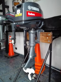
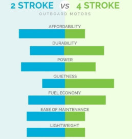
2 STROKE OUTBOARDS vs 🪸 CORAL
Two-stroke outboard engines—especially older carbureted models—can have significant negative environmental impacts, particularly in sensitive ecosystems like coral reefs.
🔥 1. Fuel and Oil Pollution
• Unburned fuel: Traditional two-stroke engines mix oil directly with gasoline. As much as 25–30% of this fuel/oil mixture is released unburned into the water.
• Hydrocarbons: These petroleum residues contain polycyclic aromatic hydrocarbons (PAHs), which are toxic to marine life, including coral polyps, fish larvae, and invertebrates.
• Localized slicks: The oily sheen from outboards can settle on the surface or disperse near the reef, blocking light and smothering sensitive coral tissues.
🧬 2. Toxic Effects on Coral Reefs
• Coral bleaching sensitivity: Corals under stress from warming waters are more vulnerable to chemical pollutants, which can increase bleaching and mortality.
• Disruption of reproduction: PAHs and other compounds can disrupt spawning in corals and fish.
• Altered microbiomes: Small fuel spills can change the microbial balance around coral reefs, which may weaken coral immune responses.
🐠 3. Harm to Marine Fauna
• Larvae and juvenile fish: These are especially susceptible to toxins, affecting reef fish populations and recruitment.
• Bioaccumulation: Toxic compounds can accumulate up the food chain, impacting fish health and the animals (including humans) that eat them.
🧭 Bottom Line:
Old two-stroke engines are among the most polluting marine power sources. In coral reef zones, their use should be banned altogether to protect fragile ecosystems already under stress from climate change, overfishing and overtourism.
Local snorkel, dive operations and water taxis should immediately switch to 4 stroke engines.
Impacts of emissions from outboard motors on the aquatic environment:
In general, two-stroke engines emit ca. 10-times more pollution than 4-stroke engines because of lower trapping efficiencies inherent in the 2-cycle operation. Unlike 4- stroke engines that have separate exhaust and fuel filling cycles, in 2-stroke engines the exhaust and fuel filling occur in the same stroke, resulting in an un-preventable loss of unburned fuel in the exhaust. Depending on load and configuration, it has been reported that 2-stroke engines release 1-40% of their fuel unburned to the water.
Warrington (1999) concluded that 10-25% was a more typical range for normal use of modern 2-stroke engines. Although the data is somewhat out-dated (1973), to give this a global perspective, Jackiviz and Kuzminski (1973) calculated that of the 3.8 billion litres of fuel used per year by outboard engines, 380-600 million liters are discharged (unburned) into the water.
FOLLOW THE MONEY
• The total global outboard engine market for annual sales is around 800,000 units per year, with four-strokes growing but two-strokes continue to hold a massive user base.
• In 2024, the two-stroke engine segment (across all marine propulsion—not just outboards) held approximately 60% market share
• Specifically for outboards, two-strokes were valued at US$1.15 billion in 2024, compared to US$2.8 billion for four-strokes
• The global 2-stroke outboard engine market itself was estimated at about US$1.2 billion in 2024 .
OCEAN POSSE BBQ MEET UP 🔥
MARINA TAHINA 🇵🇫 TAHITI
SATURDAY JUL 14 14:00 – 16:00
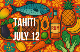
Captain Alan of SY Cyrolia and Marina Tahina are hosting an impromptu BBQ this Sunday at Marina Tahina. 🧭 Bring Your finest grill-worthy protein anda side dish or treat to share with the fleet
🍹 Free Rum will be provided for all
SY CYROLIA Allan Jeanneau 52

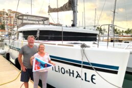
THE VENERABLE GOIOT 🛠️ ESCAPE HATCHES
Hatch Failure – SV Pathfinder Loss Report
In May 2025, SV Pathfinder, a 2025 Ocean Posse vessel, sank off the island of Tahuata in the Marquesas. The hatch lens on one of the escape hatches detached in moderate conditions. The vessel was lost. The Goiot bracket recall fix had been installed.
The hatch in question was a Goiot model. Goiot issued a recall covering models manufactured between 2007 and 2019. The recall kit included two stainless brackets, each secured with two small self-tapping screws into the gelcoat. These brackets had been installed on Pathfinder.
On SV Iliohale (Lagoon 450S, 2016), hatch lenses were removed and resealed prior to departing for the Pacific Ocean in early 2025. Two additional stainless brackets were installed on each hatch. Larger screws were used. Sealant was applied between the brackets, gelcoat, and glass. The original sealant removed from the hatches had deteriorated and came off in flakes. After 4,000 nautical miles, the modified hatches remained watertight.
Other owners in the 2025 fleet reported removing hatches and glass entirely. Some reported fabricating custom enclosures. Several reported contacting insurers prior to modification. At least one report involved successfully plugging a failed hatch opening with a mattress. One crew reported using a pre-cut plexiglass panel and fasteners. Multiple vessels reported installing bilge alarms after Pathfinder’s loss.
No known case has been documented in the Ocean Posse or broader cruising fleet in which a catamaran crew exited through a hatch after a capsize.
 Allan & Rina – Lagoon 45′
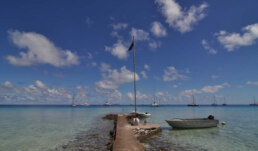
SUWARROW  COOK ISLANDS
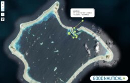
⚓ Suwarrow Anchorage Overview
📍 Location: 13° 14.9580′ S 163° 6.4760′ W
• Part of the Northern Cook Islands, Suwarrow is a national park managed by the Cook Islands Conservation Service.
• Accessible only by private yacht; no ferry or commercial transport available.
🛟 Approach and Anchorage Details:
• Pass Entry: One narrow pass on the western side; lined with coral reefs and best navigated in daylight at slack tide. The pass is dog-legged, with cross-currents and limited margin for error.
• Anchoring Area: Inside the lagoon, only Anchorage Island offers a designated anchorage.
◦ Depth: 8 to 20 meters
◦ Bottom: Mostly sand with scattered coral heads (bommies)
◦ Holding: Good, but visibility and bommie clearance are essential.
◦ Tip: Use floats on your chain to prevent wrapping coral.
🏝 Onshore and Park Rules:
• Ranger Station: A seasonal ranger lives on Anchorage Island (June to November). All yachts must check in upon arrival.
• Fees: Roughly $50 USD per yacht for up to 2 weeks (subject to change; cash preferred).
• Waste: Pack it in, pack it out – absolutely no trash disposal on the island.
• No Fishing: Suwarrow is a protected marine reserve. Fishing and spearfishing are strictly prohibited.
🐦 Wildlife and Environment:
• Home to thousands of nesting seabirds – including red-tailed tropicbirds, frigatebirds, and sooty terns.
• Coconut crabs roam the island interior.
• Reef sharks, rays, and turtles frequent the lagoon.
• Limited snorkeling spots near Anchorage Island; mantas have been seen cleaning near coral heads.
🧭 Navigation and Tips:
1 Enter only during daylight, ideally with the sun behind you to spot reefs.
2 Avoid low tide on arrival or departure due to pass shallowness and current.
3 Bring provisions, fuel, and drinking water – there are no supplies on the island.
4 Dinghy access to the beach is usually calm, but be aware of tidal changes and coral heads near the small pier.
5 Respect the ranger’s authority – they act as park wardens and may organize beach gatherings or potlucks with cruisers.
⛵ Suwarrow in Perspective:
This is not a marina stop – it’s a castaway dream. No shops, no noise, just stars, reef, and wildlife. Suwarrow is often described as a spiritual reset button for bluewater sailors. It’s wild, remote, and unforgettable.
Would you like a chartlet with anchorage GPS tracks, suggested entry waypoints, or a printable cheat sheet for crew briefings?
Weather SUWARROW COOK ISLANDS
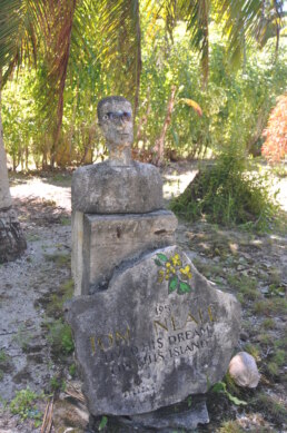
Tom Neale 🏝️ an island to oneself

For sailors, the Pacific Ocean has long represented a vast, almost mystical frontier, an expanse of blue water scattered with far-flung atolls and emerald isles. Among these is Suwarrow Atoll, part of the Cook Islands, an isolated ring of coral in the northern reaches of the South Pacific. It is here that one man, Tom Neale, chose to live alone for years at a time, becoming one of the most iconic figures in the modern history of solitude and survival at sea. Born in New Zealand, Tom Neale was not a hermit in the traditional sense. Rather, he was a sailor, a dreamer, a philosopher of the sea who chose to turn his back on the conventional comforts of society in pursuit of peace, self-reliance, and spiritual communion with the ocean. His book, An Island to Oneself, recounts his years living alone on Suwarrow, and has inspired generations of cruisers, adventurers, and romantics. Neale’s time on Suwarrow wasn’t an accident. It was a long-held dream, meticulously planned and passionately pursued. His experience stands as a profound testimony to the human spirit’s capacity for adaptation, endurance, and joy in nature’s rhythms.
The Making of a Castaway
Thomas Francis Neale was born in Wellington, New Zealand, in 1902. He grew up in the coastal settlement of Greymouth and later lived in the Bay of Islands. From an early age, he developed a deep fascination with boats, the ocean, and the idea of a simpler life away from the bustle of cities.
By his twenties, Neale began moving through various jobs across the South Pacific, including work in the Royal New Zealand Navy, inter-island trade, copra plantations, and boat maintenance. These experiences not only seasoned his seamanship but exposed him to the rhythms of Pacific island life, a rhythm he came to deeply respect and admire.
He first heard of Suwarrow in the late 1940s while in Rarotonga, from sailors and islanders who spoke of a beautiful but abandoned atoll in the Northern Cook Islands. It had been briefly occupied during World War II by a New Zealand coastwatcher station, but was now deserted. The remnants of buildings and equipment left behind presented, in Neale’s eyes, a rare opportunity: a remote island already equipped with some infrastructure and fresh water, ripe for a self-sufficient existence.
First Sojourn: 1952 to 1954
Neale’s first trip to Suwarrow in 1952 was facilitated by a ship from Rarotonga. He arrived with supplies, books, tools, seeds, and a cat named Missie. Over the next several months, he transformed the remains of the coastwatcher station into a livable homestead. He cleaned the well, repaired the house, built a chicken coop, planted a garden, and fished daily.
His daily life followed the sun. He rose with the dawn, tended to his food stores and garden, checked his fish traps, and spent hours maintaining tools and structures. Rainwater was carefully conserved. He read voraciously, classics, philosophy, nautical texts, and novels, keeping meticulous journals and recording his thoughts.
Neale wasn’t completely alone; occasional passing yachts stopped by, and once a year the government vessel Tiare Taporo brought supplies or visitors. Yet for months at a time, he saw no one, relying entirely on his ability to adapt to the island’s demands.
A back injury from lifting a heavy anchor nearly ended his solitude in tragedy. Unable to move for days, he survived only because of a fortunate visit by a passing yacht, which evacuated him to Samoa for medical treatment.
Return and Second Stay: 1960-1963
After recovering in Rarotonga, Neale spent the next few years biding his time, regathering supplies, and preparing to return to his beloved island. In 1960, he embarked on his second stay, better prepared and more experienced.
This time, he stayed over three years, facing cyclones, crop failures, and emotional isolation. Yet he continued to write, fish, grow food, and expand his philosophical reflections. His journals show increasing depth and introspection, often comparing his solitude to monastic discipline.
One of his most significant reflections was his relationship with time. Without clocks or appointments, his days flowed with the tide, the sun, and the needs of his body and the land. He described this freedom from time as the most powerful transformation solitude had brought him.
Final Return: 1967 – 1977
Neale returned for a third and final time in 1967, older and slower, but just as passionate. He was now something of a legend. Yachties knew of him; some came specifically to meet the “Hermit of Suwarrow.” Though visitors became more frequent, he remained a solitary figure, often preferring quiet reflection over long conversations.During this last period, Neale continued to maintain his home and routines. His cat Missie had died, and he eventually took in new feline companions. He still gardened and read, though more slowly. His health began to decline, but he remained deeply committed to his life on the atoll.In 1977, after years of self-sufficient living and declining health, he was finally evacuated due to illness. He died in Rarotonga later that year at the age of 75.
Philosophy and Perspective
Tom Neale’s life has often been romanticized, but at its heart it was a life of deliberate simplicity. He did not reject society out of anger or misanthropy, but rather out of a profound desire to reconnect with the earth and the sea on his own terms.
He believed that many modern conveniences were distractions, walls between people and the natural world. In solitude, he found clarity. In routine, he found discipline. And in hardship, he found gratitude.
Neale’s writing never preaches. It simply recounts. Yet the underlying message of An Island to Oneself is clear: the modern world does not satisfy all souls. Some require something wilder, quieter, and more elemental.
Final Reflections: A Life of Intention
Tom Neale didn’t escape to Suwarrow out of desperation, but out of intention. In a world that increasingly prizes connectivity, urgency, and consumption, his example stands in quiet contrast. He reminds us that it is possible, and perhaps necessary, to step outside the noise, to listen to the wind, and to live by the tide.
As he once wrote:
“Solitude, the ocean, the stars, what more could a man want? I am not a philosopher. I am not even particularly wise. But I do know that I have lived, and that is something.”
AWARD ENTRY 🏆 UNINVITED VISITORS
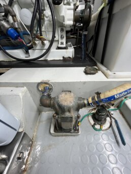
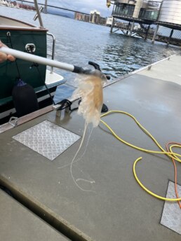
Is it too early for entry in the Most Unwanted Visitor category? Our generator stalled suddenly. Found parts of a jellyfish in the intake strainer. Lucky Chucky still could not start the generator even after using a snake and a vacuum. Finally the compressor hose on a scuba tank blew out the blockage. Out came a jellyfish from the intake. Big one too. Now the generator is back working. Hurray!
MY HO’OKIPA Lisa & Lucky Chucky – Selene 43′


OCEAN POSSE PARTNERSHIP MARINAS

🇦🇺 AUSTRALIA
🇧🇸 BAHAMAS
-
 Browns Marina
 -
 Elizabeth on the Bay Marina
 -
 Blue Marlin Cove Resort & Marina
 - Great Harbour Cay Marina
-
 Romora Bay Resort and Marina
🇧🇿 BELIZE
🇧🇲 BERMUDA
🇧🇷 BRAZIL
🇻🇬 BRITISH VIRGIN ISLANDS
🇨🇻 CAPE VERDE
🇰🇾 CAYMAN ISLANDS
🇨🇱 CHILE
🇨🇴 COLOMBIA – Caribbean
-
 Club Nautico Cartagena
 -
 Club de Pesca Marina Cartagena
 -
 Marina Puerto Velero
 -
 IGY Marina Santa Marta
  Manzanillo Marina Club
🇨🇷 COSTA RICA – Pacific Coast
🇨🇺 CUBA
🇩🇲 DOMINICA
🇩🇴 DOMINICAN REPUBLIC
🇪🇨 ECUADOR
🇸🇻 EL SALVADOR
🇬🇮 GIBRALTAR
🇬🇩 GRENADA
🇬🇵 GUADELOUPE
🇬🇹 GUATEMALA – Pacific Coast
🇬🇹 GUATEMALA Rio Dulce
🇫🇯 FIJI
 Copra Shed Marina
 Nawi Island Marina
  Denarau Marina
-
 Musket Cove
  Royal Suva Yacht Club
 Sau Bay Moorings
🇭🇳 HONDURAS – Bay of Islands – Roatan
🇮🇹 ITALY
 Marina dei Presidi
  Marina di Balestrate
 Marina di Brindisi
 Marina di Cagliari
 Marina di Chiavari
 Marina di Forio
  Marina di Teulada
 -
 Marina di Policoro
 -
 Marina di Vieste
 -
 Marina de Procida
 -
 Marina de Villasimius
 - Marina di Vieste
-
 Marina Molo Vecchio
  Marina Salina
  Venezia Certosa Marina
🇯🇲 JAMAICA
🇲🇶 MARTINQUE
🇲🇽 MEXICO – Caribbean
- Marina Makax – Isla Mujeres
- Marina Puerto Aventuras
- Marina V&V – Quintana Roo
- Marina El Cid – Cancún
🇲🇽 MEXICO – Pacific Coast
- ECV Marina – Ensenada BC
- IGY Marina Cabo San Lucas BCS
- Marina Palmira Topolobampo – SI
- Marina y Club de Yates Isla Cortes – SI
- Marina el Cid – Mazatlan – SI
- Marina Vallarta, Puerto Vallarta – JA
- Marina Puerto de La Navidad – Barra de Navidad – CL
- Marina Ixtapa, Ixtapa – GE
- La Marina Acapulco, Acapulco – GE
- Vicente’s Moorings, Acapulco – GE
- Marina Chiapas – CS
🇳🇿 NEW ZEALAND
🇳🇮 NICARAGUA – Pacific Coast
🇳🇺 NIUE
🇵🇦 PANAMA – Pacific Coast
🇵🇦 PANAMA – Caribbean
- Shelter Bay Marina
- Bocas Marina
- Solarte Marina
- Linton Bay Marina /a>
- Turtle Cay Marina
- IGY Red Frog Marina
🇵🇹 PORTUGAL
🇵🇷 PUERTO RICO
🇱🇨 SAINT LUCIA
🇸🇽 SINT MAARTEN
🇪🇸 SPAIN
 Alcaidesa Marina
  IGY Málaga Marina
  Marina Del Odiel
  Nautica Tarragona
  Puerto Sotogrande
 Yacht Port Cartagena
🇰🇳 ST KITTS & NEVIS
🇹🇳 TUNISIA
🇹🇴 TONGA
🇹🇨 TURCS AND CAICOS
🇻🇮 US VIRGIN ISLANDS
🇺🇸 USA – East Coast
- Safe Harbor – Marathon, FL
- Pier 66 Hotel & Marina – Ft. Lauderdale, FL
- Titusville Marina – FL
- Port 32 Marina Jacksonville – FL
- Oasis Marinas at Fernandina Harbor Marina – FL
- Morningstar Marinas Golden Isles St. Simons Isl. – GA
- Windmill Harbour Marina – Hilton Head , SC
- Coffee Bluff Marina – Savannah GA
- Hazzard Marine – Gerogetown, NC
- Holden Beach – Town Dock, NC
- Tideawater Yacht Marina, Portsmouth, VA
- Ocean Yacht Marina, Portsmouth, VA
- York River Yacht Haven – VA
- Yorktown Riverwalk Landing – VA
- Regatta Point Marina – Deltaville, VA
- Regent Point Marina – Topping, VA
🇺🇸 USA – Pacific Coast
- Safe Harbor Ventura Isle, Ventura CA
- Vintage Marina , Oxnard, CA
- Safe Harbor South Bay – Chula Vista, CA
🇻🇺 VANUATU
Primary Named Winds in the Mediterranean 🌬️Meltemi (Etesian)
| Name | Direction | Region | Effect on Sailing |
Meltemi (Etesian) |
N or NW | Aegean Sea (Greece, Turkey) |
Strong seasonal summer wind (May–Sept); good for N-to-S passages, dangerous for S-to-N.
|
Meltemi Winds – Aegean Summer Sailing
During the summer months in Greece, a regional pressure gradient sets the stage for the Meltemi Winds, a dominant weather pattern in the Aegean Sea. A high-pressure system builds over the Balkans, while a thermal low develops over Turkey. This contrast draws strong northerly winds across the Aegean, especially from mid-June through September.
The Meltemi typically peaks during the day and eases overnight. It’s driven in part by the differential heating of land and sea, hot air over the mainland rises, pulling in cooler air from the north and northeast. While sometimes referred to as part of a broader Siberian High or influenced by distant pressure systems like the Aleutian Low, the main mechanism is regional and seasonal.
For sailors, the Meltemi is a double-edged sword. Its strength and reliability make for exhilarating passages under sail, but conditions can quickly become challenging:
-
Wind Strength: Regularly force 5-7 Beaufort, occasionally higher in funneling channels like between Andros and Tinos or around the Cyclades.
-
Sea State: Builds rapidly, especially in open fetch areas, expect steep, short-period waves.
-
Anchoring: Secure holding is essential; some anchorages offer poor protection from the north.
-
Harbor Entries: Crosswinds can complicate docking maneuvers, especially in small island ports.
-
Nighttime Lulls: Winds often ease at night, but not always, plan passages accordingly.
Still, for experienced cruisers prepared for spirited conditions, the Meltemi offers a uniquely Greek sailing experience—dry, cool, and beautifully bracing on a hot July afternoon.
MUST SEE ALONG THE OCEAN POSSE ROUTE
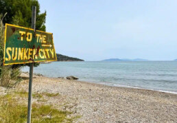
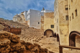
Sunken City of Epidaurus + ANCIENT THEATER 🇬🇷 GREECE
37° 37.90′ N 023° 9.68′ E
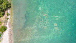
Off the clear waters of Gliati (also called Kalimnios beach), just northeast of Ancient Epidaurus, lie submerged ruins often referred to as the “Sunken City.” Here’s a glimpse into this enchanting underwater site. This is a rare spot where ancient architectural footprints lie just beneath the waves, easily accessible to anyone with a snorkel and sense of wonder.
🧭 What you’ll see
• Walls, foundations, paving stones, roads, and even remnants of a Roman breakwater
• “You can clearly distinguish building foundations, amphorae, remnants of the ancient walls and even floor sections… mementos of a forgotten city whose only residents today are colorful fish and giant urchins”
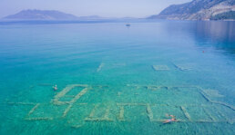
- Ideal for both history enthusiasts and amateur snorkelers—no deep diving required.
- Gives a surreal feeling, floating above nearly intact ancient pavements and structures.
- Offers a tangible connection to a Roman coastal past, where villas met the sea
If the sea is rough and the waves are high, it’s best to stay out of the water. Visibility will be poor, and conditions can become hazardous. Sharp rocks and sea urchins are common in the area and can cause serious injuries.
When visiting the ruins, avoid stepping on or touching the tops of the ancient walls. While it might seem possible, doing so risks damaging a fragile site that was only uncovered about 50 years ago. These structures are delicate and irreplaceable. Preserving them ensures future generations can experience this unique glimpse into the past.
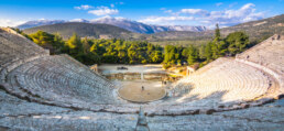
< 1/2 nm VERY NEARBY Theatre at the Ancient City of Epidaurus
The Theatre at the Ancient City of Epidaurus is considered the best-preserved example of a classical Greek theater. Built in the 4th century BCE by the architect Polykleitos the Younger, it sits within a forested hillside near the Sanctuary of Asclepius, the ancient healing center dedicated to the god of medicine. The theater was created to host dramatic performances tied to religious and healing rituals, reflecting the Greek belief that art, nature, and health were deeply interconnected.
The most striking feature of this ancient structure is its exceptional acoustics. The design allows even the softest sounds made at center stage to be heard in the uppermost seats. It originally held about 6,000 people, but was later expanded during Roman times to accommodate up to 14,000 spectators. The seating area is divided into two parts, with 21 rows from the classical period and 20 more added later. The limestone material used in construction plays a key role in its acoustic clarity.
Despite centuries of exposure, the theater remains in remarkable condition. Today, it still hosts performances, especially during the summer Epidaurus Festival. Watching a play here under the stars, with the ruins around you and the mountains beyond, is an experience few forget.
MEET THE FLEET 🇨🇦 SY GARGOYLE II
1. About the Boat and the Voyage So Far
Our current vessel is Gargoyle II, the successor to the original Gargoyle, a steadfast Beneteau Oceanis 50 that was our home for over nine years and carried us more than 45,000 nautical miles. We’re now sailing in Greece, enjoying our second season here. It’s hard to pick a favorite destination, but it’s a tie between the wild beauty of the Galápagos Islands and the remote, dreamlike Tuamotus in French Polynesia.
2. Why We Sail
We stepped away from the traditional work lifestyle in search of something more adventurous, and life aboard has offered us a much broader view of the world. Cruising has reminded us just how fundamentally similar people are, regardless of borders or backgrounds. For us, sailing is a deeply personal journey – a way to make the most of the limited time we all have, and to experience the richness of life from a unique vantage point.
3. Moments, Lessons, and Connections
One defining moment came when we were locked down during COVID in a fishing village in Nicaragua for six months. The community embraced us like neighbors, and that generosity left a lasting impact. Along the way, we’ve discovered how challenging it can be to manage long-standing relationships back home while living this life afloat. We also make a point to spend extended time in the places we visit – like several months in the Ionian – so we can connect more deeply with both the local culture and its people.
4. Reflections and Gratitude
Cruising continues to surprise us. Some experiences – like watching Sting perform live at the Acropolis – become unexpected bucket-list moments. We’ve been proud members of the Posse since 2019, and we’re continually grateful for the incredible people we’ve met and the unwavering support we’ve received through the years.

SY GARGOYLE 🇨🇦 Kevin & Karla – Hanse 57′


OFFICIAL OCEAN POSSE EVENTS

ANNAPOLIS BOAT SHOW 🇺🇸 MARYLAND USA
ANNAPOLIS, Annapolis Town Dock Booth VB 9

OCEAN POSSE 🇺🇸 SAN DIEGO BAY 4 DAY CRUISING SEMINARS SERIES @ SAFE HARBOR SOUTH BAY
SAFE HARBOR SOUTH BAY EVENT CENTER, CHULA VISTA, SAN DIEGO, CA

OCEAN POSSE KICK OFF 🇲🇽 BARRA DE NAVIDAD, MEXICO December 3-7 2025
MARINA PUERTO DE LA NAVIDAD, BARRA DE NAVIDAD, MEXICO


OCEAN POSSE & BEN TAYLOR STREET PARTY @ CANNES 🇫🇷 YACHTING FESTIVAL
TAQUERIA LUPITA, 72 Rue Meynadier, Cannes
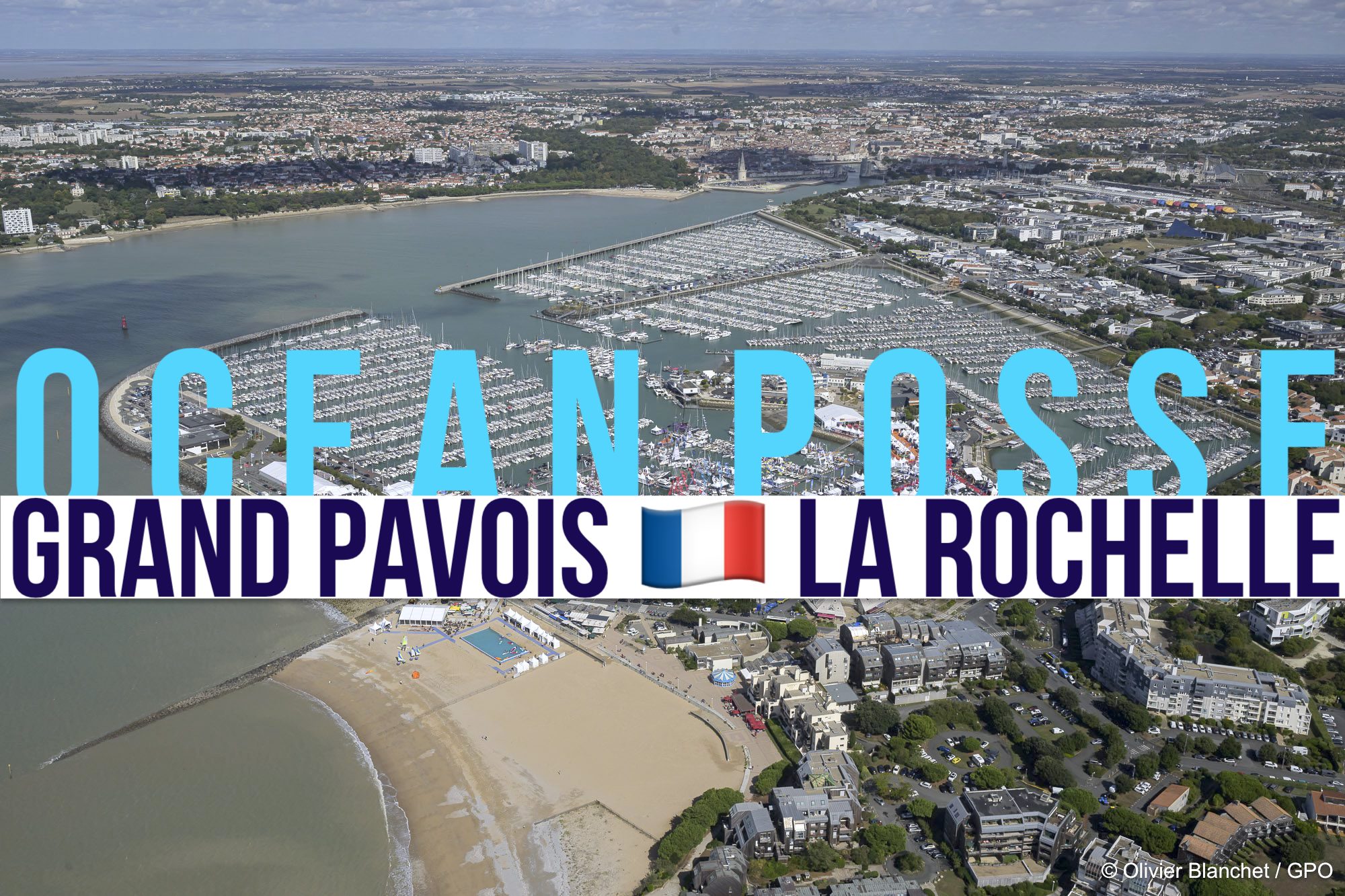
GRAND PAVOIS 🇫🇷 La Rochelle – Sep. 24 2025
Gran Pavois La Rochelle, 20 Av. de la Capitainerie, 17000 La Rochelle, France
GRAND PAVOIS 🇫🇷 La Rochelle – Sep. 24 2025
Gran Pavois La Rochelle, 20 Av. de la Capitainerie, 17000 La Rochelle, France
GRAND PAVOIS 🇫🇷 La Rochelle – Sep. 24 2025
Gran Pavois La Rochelle, 20 Av. de la Capitainerie, 17000 La Rochelle, France
GRAND PAVOIS 🇫🇷 La Rochelle – Sep. 24 2025
Gran Pavois La Rochelle, 20 Av. de la Capitainerie, 17000 La Rochelle, France
GRAND PAVOIS 🇫🇷 La Rochelle – Sep. 24 2025
Gran Pavois La Rochelle, 20 Av. de la Capitainerie, 17000 La Rochelle, France
INTRODUCING A NEW SPONSORSHIP MARINA
SCARBOROUGH MARINA 🇦🇺 BRISBANE – SPONSORS THE OCEAN POSSE
27° 11.6016′ S 153° 06.4233′ E
We are excited to welcome the Ocean Posse members to our marina and facilites and offer the following discounts !
• 10% off wet berthing for up to 1 month – for the initial term only (1 time only offer).
• 10% off Haul-out and Hardstand services for up to 5 days (1 time only offer).
• 30% off Liveaboard fees
• Terms and conditions apply

SERVICES

NEARBY
1. South Bank Parklands
Stroll the lush riverside paths, dip into the man-made beach lagoon, or relax in shady gardens. A central hub for dining, public art, and people-watching.
2. Lone Pine Koala Sanctuary
Get close to Australia’s native wildlife. Hand-feed kangaroos, hold a koala, and observe a wide range of birds, reptiles, and marsupials.
3. Mount Coot‑tha Lookout & Botanic Gardens
Soak in panoramic views over the city and visit the subtropical gardens below, complete with a planetarium and walking trails.
4. Story Bridge Adventure Climb
Climb Brisbane’s iconic steel bridge for stunning views of the river, skyline, and mountains. A top pick for sunrise or twilight adventurers.
5. Queensland Art Gallery & Gallery of Modern Art (QAGOMA)
An impressive cultural complex showcasing world-class contemporary and Indigenous art in innovative, spacious settings.
6. Brisbane Powerhouse & New Farm Park
This converted industrial space hosts theatre, live music, and exhibitions. Nearby, New Farm Park offers scenic riverside picnics and jacaranda blooms in spring.
7. City Botanic Gardens
Brisbane’s oldest park, located on a bend in the river. A calm escape with rare tropical plants, heritage trees, and walking paths.
8. Eat Street Northshore
A vibrant night market built from shipping containers, offering global street food, desserts, live music, and craft stalls under fairy lights.
9. Howard Smith Wharves
A revitalized waterfront zone with breweries, upscale restaurants, and lively bars tucked beneath the Story Bridge.
10. West End & Boundary Street Markets
A creative, multicultural district full of indie shops, vintage stores, global cuisine, weekend markets, and a laid-back, bohemian atmosphere.


OCEAN POSSE SPONSORS
- ABERNATHY – PANAMA
- BELIZE TOURISM BOARD
- BOAT HOW TO
- CABRALES BOAT YARD
- CENTENARIO CONSULTING – PANAMA CANAL
- CHRIS PARKER – MARINE WEATHER CENTER
- DELTA MIKE MARINE SUPPLY PANAMA
- DIGITAL YACHT
- DOWNWIND MARINE
- EL JOBO DIST. COSTA RICA
- FLOR DE CAÑA
- HAKIM MARINA AND BOAT YARD
- HERTZ RENTAL CARS MEXICO
- HOME DEPOT PRO MEXICO
- LATITUDES AND ATTITUDES
- MARINA PAPAGAYO
- NOVAMAR YACHT INSURANCE
- PANAMA YACHT BROKER
- PREDICT WIND
- SAFE HARBOR SOUTH BAY MARINA EVENT CENTER
- SAN DIEGO MARINE EXCHANGE
- SAFETY ONBOARD COSTA RICA
- SEVENSTAR YACHT TRANSPORT
- SHAFT SHARK
- SUN POWERED YACHTS
- WESTMARINE PRO
- YACHT AGENTS GALAPAGOS
MEDIA PARTNERS
LATITUDES AND ATTITUDES

OCEAN POSSE FLEET 🛰️ TRACKING
![]()
This page is designed to give interesting parties an overview. For specific vessel details including their floatplan, latest updates, changes, positions and specific location related questions please contact each vessel directly. Due to privacy we do not provide vessel contact information. You may track vessels via it’s own tracker or request AIS tracking from https://www.marinetraffic.com/ please note that this is also not accurate. There are many reasons why a vessel’s position is not updated and please do not conclude that a vessel has an emergency or is in need of assistance because it has not reported in lately. Sometimes they may just want to get away from it all and not tell you where they are. It is the responsibility of each vessel to file a float and check in plan and escalation procedures.
JOIN THE OCEAN POSSE
|
||||||||||||||||||||||||||||||||||||||||||||||||||||||||||||||||||||||||||||||||||||||||||||||||||||||||||||||||||||||||||||||||||||||||||
| MEET UP @ BOAT SHOWS AROUND THE WORLD | ||||||||||||||||||||||||||||||||||||||||||||||||||||||||||||||||||||||||||||||||||||||||||||||||||||||||||||||||||||||||||||||||||||||||||
| SAVE MONEY, TIME AND REDUCE BOAT STRESS | ||||||||||||||||||||||||||||||||||||||||||||||||||||||||||||||||||||||||||||||||||||||||||||||||||||||||||||||||||||||||||||||||||||||||||
|
TIDBITS
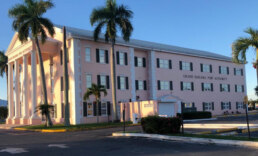
BALBOA YACHT CLUB IN PERIL
SY RAMBLE ON ROSE 🇺🇸 Rose & Don – Caliber 40 ‘
OCEAN POSSE CANAL AGENT
CENTENARIO CONSULTING
info@centenarioconsulting.com
www.centenarioconsulting.com
Cellphone +507 6676-1376
WhatsApp +507 6676-1376

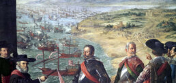
The 1914 Panama Canal 50 dollar bill is a remarkable artifact from the early 20th century, commemorating one of the most significant engineering achievements in maritime history. Issued during or shortly after the canal’s completion, these rare banknotes were either U.S. Treasury issued or linked to special commemorative series from the Canal Zone or associated institutions. They reflect the pride and ambition of an era that reshaped global trade.
The Panama Canal officially opened on August 15, 1914, after more than a decade of intense labor, geopolitical negotiation, and technical innovation. Cutting through the Isthmus of Panama, it connected the Atlantic and Pacific Oceans and instantly transformed global shipping. Vessels that once had to endure the long and dangerous voyage around Cape Horn could now transit the Americas in a fraction of the time.
While no U.S. Federal Reserve Note was issued in 1914 explicitly featuring the canal, several commemorative certificates and Canal Zone related notes exist. These often depict imagery symbolic of U.S. industrial might and international reach, including allegorical figures of commerce, infrastructure, and possibly vignettes representing the locks or canal workers.
If a note was created or commissioned around this time to honor the canal, especially in denominations like 50 dollars, it would have been a prestige item, not common currency. These notes are now of interest to collectors for their historical relevance, scarcity, and often ornate design.
2025 CRUISING FEES IN 🇧🇸 THE BAHAMAS
Here’s the updated fee structure under the new Bahamas Port Authorities (Amendment) Bill taking effect July 1, 2025, which introduces significant changes for vessels entering Bahamian waters s
🚤 Pleasure Vessel Entry Fees & Permits
1. Temporary Cruising Permits (up to 12 months)
• ≤ 34 ft: $500
• 35–100 ft: $1,000
• > 100 ft: $3,000
• Tenders > 25 ft: $500
These now include customs, immigration attendance and overtime charges
2. Frequent Digital Cruising Card (FDCC) – valid 2 years, unlimited entries
• ≤ 34 ft: $1,500
• 35–100 ft: $2,500
• > 100 ft: $8,000
3. Fishing Permit Fees
• ≤ 34 ft: $100
• > 34 ft: $300
4. Anchorage Fees (foreign vessels not at marina)
• ≤ 34 ft: $200
• 35–100 ft: $350
• > 100 ft: $1,500
5. Passenger Tax
Additional passengers (≥ 6 years, non-residents) beyond first 3 incur $30 each
✅ What’s New
• Sharp increases compared with previous permits (e.g., ≤ 100 ft temp permit jumped from $300 to $1,000) .
• Mandatory AIS for all foreign vessels in Bahamian waters; non-compliance fines of $1,000
• New 2‑year FDCC option for frequent cruisers.
🔍 Compared to Previous Regime
Under the 2020–2024 system:
• Temporary cruising permit:
◦ ≤ 34 ft = $150 (3 mo) or $300 (12 mo);
◦ 35–99 ft = $300 (90 d) or $600 (12 mo)
• No FDCC; anchorage was a modest daily rate via park fees.
• Fishing permits: $100–$300 depending on size .
• AIS requirement is brand new
🗓️ Effective Date
All new fees and AIS rules take effect July 1, 2025
💡 What This Means for Your Ocean Posse Fleet
• Plan ahead: AIS installation and functioning system required. ( most folks have this )
• Evaluate whether the FDCC is worth the investment for frequent entrants.
• Prepare for substantially higher entry costs, particularly for larger yachts.
WHO IS BEHIND THIS INCREASE IN FEES
These fee hikes and new rules were crafted and enacted by the Bahamas Parliament via the 2025 Amendment Bill
• Prime Minister Philip “Brave” Davis – Serving since September 17, 2021, as the 5th PM of the Bahamas and also Minister of Finance. He leads the government and the majority in the House of Assembly
• Speaker Patricia Deveaux – The presiding officer in the House of Assembly, elected October 6, 2021. Notably, she handled a high-profile incident involving the mace being thrown during a session
• President of the Senate Lashell Adderley – Elected October 7, 2021, she oversees the upper house’s proceedings and ensures decorum
• Leader of the Opposition Michael Pintard – Representing the Free National Movement, he assumed the role on November 27, 2021, leading the minority in parliamentary debates • Dame Cynthia Pratt, the Governor‑General since September 2023, officially represents the King in parliamentary matters
THESE NEW LAWS ARE carried out through the Port Department and Ministry of Transport, with input from the Maritime Authority and Tourism Ministry.
The Minister of Energy and Transport in The Bahamas is Hon. JoBeth Coleby-Davis.
The leader of the Bahamas Ministry of Tourism, Investments & Aviation is The Honourable I. Chester Cooper
Leadership of the Bahamas Port Authority
• Ian B. A. Rolle – President
Ian Rolle, a certified public accountant and former Ernst & Young professional, serves as President of GBPA, leading its municipal operations, harbor services, and development initiatives for Freeportx
• Rupert Hayward – Co‑Chairman Rupert Hayward holds the role of Co‑Chairman of the GBPA board. He is a key principal and executive overseeing strategic oversight and multi-industry operations across the Port Group
Extraordinary Cruising °°° Join the Fleet
- Access vetted local knowledge, safety resources, and prior experiences to make your passage safer and more enjoyable.
- Unlock a Life of Adventure
Explore hidden destinations, experience new cultures, and discover the freedom of life at sea or near shore – on your terms. - Get VIP Perks & Discounts at marinas, chandleries and boatyards
Get exclusive discounts, priority access, and personalized support at partner marinas across the globe. - Observe the actions of Experienced Captains
Tap into a wealth of tips, tools, and real-world know-how from seasoned mariners to grow your skills and gain confidence. - Make Every Nautical Mile Memorable
Join events, meetups, and shared journeys that turn you voyages into unforgettable stories and lasting memories. - Cruise with a Conscience
Gain insights into sustainable practices and join a movement that protects the waters you love to explore.
CRUISING ° FLEET UPDATE & NEWS 2025-06-15
“This Fall, I’m Sailing Away from the Noise.”
⛵CRUISING ° FLEET UPDATE & NEWS 2025-06-15
🌀 Hurricane Season in the East Pacific
📸 Pictures of the Week
🐾 Ocean Posse Pets Helping Pets
🏝️ Asinara National Park – Sardinia
⚓ Vintage Marina California – Channel Island Harbor
🍖 Ocean Posse BBQ Meet-Up – Marina Tahina, Tahiti
🦈 Fakarava South Anchorage – French Polynesia
☁️ PredictWind Marine Meteorology – Clouds
🔭 Must-See Along the Ocean Posse Route – CADIZ Spain
💧 The Watermaker Seminar Series
👨👩👧👦 Meet the Fleet – SY Njorth Clan
🇬🇩 Clarkes Court Boatyard & Marina Sponsors the Ocean Posse
🐋 The Orcas.pt Interview with Rui
📆 Official Ocean Posse 2025-2026 Schedule
🗞️ Media Partners – Latitudes and Attitudes
📡 Ocean Posse Fleet Tracking
🏊 Swim Through the Canal
🐳 Whale Superhighways Visualized
🌟 Extraordinary Cruising – Join the Fleet
HURRICANE SEASON IN THE EAST PACIFIC
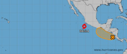
HURRICANE SEASON Season timing: Runs from May 15 to November 30 in the Eastern Pacific—officially underway since mid‑May
• So far (mid‑June):
◦ Alvin: formed May 28 as the first named storm; trekked west offshore and dissipated by May 31
◦ Barbara: became the first hurricane of 2025 on June 9 (Category 1, ~75 mph); weakened by June 10 and dissipated mid‑month
◦ Cosme” formed June 8–9; neared hurricane strength but also weakened by June 10
◦ Dalila: formed yesterday “P Tropical Cyclone Four‑E” (by June 15) with advisories and watches are active for southwest Mexico 🇲🇽
Outlook: National Hurricane Center highlight an active early season, with multiple systems likely through June
Why It’s Active
◦ This follows one of the slowest starts in 30+ years, but has quickly ramped up
◦ Favorable conditions off Mexico (Madden‑Julian Oscillation and warm sea surface temps) have boosted cyclone formation
◦ ENSO (El Niño Southern Oscillation) is neutral—not strongly El Niño or La Niña—which typically supports robust activity
• Forecasts:
◦ NOAA projects 12–18 named storms in the Eastern Pacific (~5–10 hurricanes, 2–5 major), leaning toward a below‑to‑near‑normal season
◦ Mexico’s Servicio Meteorológico Nacional anticipates 16–20 storms, 8–11 hurricanes, 4–6 majors
Impact & Coastal Risk
• Most Eastern Pacific storms stay offshore, tracking west–northwest well south of Mexico’s coast nhc.noaa.gov.
• They can still produce dangerous surf, rip currents, and heavy rainfall in coastal areas of Mexico; even remnants may deliver moisture to Southern U.S.
• Very rare for these systems to affect the U.S. West Coast as hurricanes—last major landfall was circa 1858 near San Diego
1. Stay Updated Daily 🔎
-
Monitor NHC forecasts: https://nhc.noaa.gov
-
Using tools like PredictWind and NHC storm track cones.
-
Cyclone Four-E (aka Dalila will bring rain and swell to southern Pacific Mexico in the coming days.
2. Adjust Cruising Plans ⛵
-
-
Stay close to safe harbors and haul-out options
-
-
-
-
Strong moorings or tie-down systems with multiple lines with chafe guard
-
Surge protection and human support
-
Communications and emergency services or be self reliant for the duration for the storm plus 1 week buffer for local retunr to normalcy
-
-
3. Prep for Worst-Case Scenarios 🛠️
-
-
Review and rehearse:
-
Emergency haul-out procedures
-
Storm anchor rigging (consider adding extra chain/line) dual anchors, ensure you got fuel water and food for many days after the storm passes to charge systems and maintain your vessel
-
High wind tie-downs, fendering with weights, and chafe gear
-
-
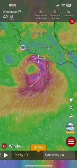
Kaliyah underway from Barra de Navidad to Marina Riviera Nayarit About 137nm (24hrs). true winds from 10 to 15 knots on our nose. Bashing and getting salty! Running away the spinning storm behind us.
SY KALIYAH Dieu & Greg Kelly-Peterson 46′


PICTURES OF THE WEEK
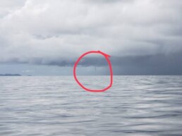
Sailing from Brincanco to Rosario and saw a waterspout a few miles away. Fun stuff
It formed and dissipated pretty quickly.
SY CAVU David & Marla – Tartan 37′
CELEBRATING YOUR WINS
MY TIDINGS OF JOY & SY BRIGADOON

Thanks for our Picture of the Year award! Enjoying our winnings with Brigadoon in Barranquilla.
To see if you won follow this link and send an email to registration@oceanposse.com to claim your bottle of Flor de Caña 12 year rum.
MY TIDINGS OF JOY Joy & Jeff – DeFever 52′
OCEAN POSSE PETS HELPING PETS
Yolanda: Hey pups! 🐾 Has any dog ever stayed at a dog hotel or sitter in Panama they actually liked? My human’s sniffing around for some trusted places. Personal sniffs only please!
Juneau: Oh yeah, I’ve bunked at VIP Vacation Kennels by the airport four times now. Stayed for about a month each time. The humans there? Total treat-givers. They post pics of us daily so our humans don’t panic. 10/10 would nap there again. 🐶✨
Yolanda: Thanks Juneau! Four stays? That sounds pawsitively solid. I’ll have my human sniff them out. 🐾
Luna: I haven’t stayed anywhere myself, but I know a human vet named Dr. Sandra—super gentle, lots of treats, great sniffer. She could help find a safe kennel. Want her details?
Yolanda: Tail wags to everyone for the recommendations! 🐾🐾
Juneau: No problem! Happy tail trails, Yolanda! 🐶💬
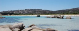
Asinara National Park 🇮🇹 SARDINIA – ITALY
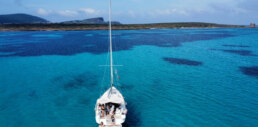
The crystalline blue waters of Asinara National Park 🇮🇹 SARDINIA – ITALY are a renowned feature of this Sardinian marine reserve
Asinara National Park
Asinara National Park for Sailors – Clear and mutliple hues of blue Anchorage in the Mediterranean
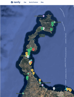
For sailors exploring the northwestern coast of Sardinia, Asinara National Park offers a rare and unforgettable stop. The island—once a quarantine station and later a high-security prison—is now one of Italy’s most protected and pristine marine areas. Located just off the coast from Stintino and Porto Torres, it lies within a designated marine reserve, with strict anchoring regulations that preserve its unspoiled beauty.
Yachts can approach from the west or north, with authorized mooring buoys available in Cala Reale, Cala d’Oliva, and Fornelli—all stunning, secluded bays surrounded by turquoise water and low-slung hills. Anchoring is restricted outside designated areas, so advance planning and park authorization are advised.
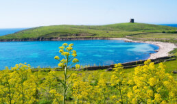
Once ashore, sailors can walk or bike the island’s network of dirt paths through Mediterranean scrub, with sweeping sea views and abundant wildlife. Albino donkeys roam freely, and you’ll often spot falcons, wild boar, and rare seabirds. The old prison ruins and the tiny village of Cala d’Oliva provide a glimpse into the island’s layered history.
Snorkeling and swimming in the crystal-clear waters reveal healthy seagrass beds and vibrant marine life. Fishing is prohibited, which has helped the underwater ecosystem thrive.
Asinara is a place to slow down, respect nature, and soak in a wilder side of the Mediterranean—an ideal retreat for cruising sailors seeking peace, protection, and something truly different.
Anchorage and mooring Locations as per Navily
GET THERE
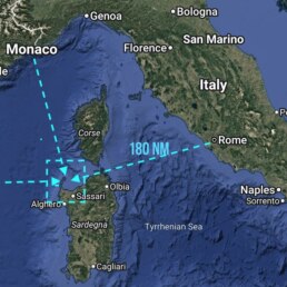
It’s an overnight sail from Rome / Civitavecchia 180 nm and about the same from Monaco and Menorca
-
The Park Authority authorizes 63 mooring buoys (for private boats) along the eastern coast—Fornelli through Cala d’Oliva—primarily active during the high season
-
In 2013, it was reported that approximately 8,600 people visited via private boats, with peak traffic in August when about 65% of the boats were present
-
Seasonal fishing-tourism operations comprised only 6 boats by 2013 (down from 13 in 2002)
HISTORY OF ASINARA
⚓ ASINARA PENAL COLONY OVERVIEW
📍 Location: Northwest Sardinia, Italy
🏝️ Island Name: Asinara (means “donkey island”)
🕰️ Key Dates
• 1885: Declared a quarantine station for infectious diseases and penal colony by Royal Decree.
• 1887–1997: Active penal colony, hosting a variety of prisoners under different regimes.
• 1997: Officially closed as a prison.
• 1998: Transferred to the Italian Ministry of the Environment.
• 2002: Became Asinara National Park and part of a marine protected area.
👥 Who Was Imprisoned?
• Common criminals: Throughout most of its history.
• Political prisoners: Especially during Italy’s fascist era (1920s–1940s).
• Anti-fascists and anarchists
• Mafia bosses: In the 1980s and 1990s, under Italy’s “41-bis” harsh prison regime, the island held dangerous Mafia figures in total isolation.
• WWI & WWII prisoners of war: Used for detaining Austrian, Hungarian, and other POWs.
Notable figures:
◦ Antonio Gramsci, co-founder of the Italian Communist Party, was briefly detained on the island before being moved.
◦ Members of the Mafia and others in the Cosa Nostra were held there under tight security.
VINTAGE MARINA CALIFORNIA
CHANNEL ISLAND HARBOR SPONSORS THE OCEAN POSSE
34° 10.2283′ N 119°13.695′ W
We are excited to support the Ocean Posse.
First night free and 25% discount on a week of transient moorings
Michelle Lapointe
Marina Manager
Vintage Marina Partners
805-984-3366
www.vintage-marina.com
3150 Harbor Blvd, Oxnard, CA 93035
AMENITIES
- Newly Renovated Concrete Docks
- Electric Hookups: 30, 50, 100 amps
- Fresh Water Hookup
- Pre-wired for Spectrum Internet/Phone/Cable
- LED/Energy Efficient Dock Lights
- Docking Assistance
- Dock Box at all Slips
- Dock Carts at all Gates
- Dry Storage for Dinghies and Kayak
- Private Coin-Operated Laundry
- Private Renovated Restroom & Shower Facility
- Oil & Bilge Pad Exchange Program
- State of the art Key System into Private Docks
- Monthly Marina Newsletters
- Stunning Succulent and Drought Resistant Landscaping
- Environmentally Friendly & Clean Marina Certified
- Daily Garbage Collection
- Ample Tenant & Guest Parking with ADA Access
NEARBY
- Promenade Walkway Around the Harbor
- Pet Friendly Environment with Bio-Doggy Waste Bags
- Weekly Farmer’s and Fisherman’s Markets
- Year-round VMP & Harbor Sponsored Events
- Close to Harbor Patrol, US Coast Guard and Fuel Dock
- Community Parks & BBQ areas
- Easy access to Hollywood Beach
- Shopping & Dinning Nearby
- Year-round Sailing Courses
- Excellent jump of point to sail to the Channel Islands
OCEAN POSSE BBQ MEET UP 🔥
MARINA TAHINA 🇵🇫 TAHITI
SATURDAY JUL 14 14:00 – 16:00
Captain Alan of SY Cyrolia and Marina Tahina are hosting an impromptu BBQ this Sunday at Marina Tahina. 🧭 Bring Your finest grill-worthy protein anda side dish or treat to share with the fleet
🍹 Free Rum will be provided for all
SY CYROLIA Allan Jeanneau 52
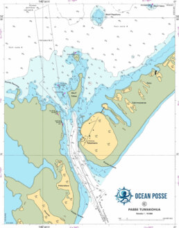
FAKARAVA 🇵🇫 SOUTH ANCHORAGE FRENCH POLYNESIA
South Anchorages: Also known as the Hirifa anchorage (southeast edge of the atoll) and the South Pass anchorage, just west of the Tumakohua (Tetamanu) pass
Protection: The anchorage lies in a sandy bay with coral bars to the north and south, offering shelter from NE around to SW winds
Float your anchor chain
⚓ Anchorage Specs & Conditions
• Depth & Holding: Typically sandy bottom at 12–15 feet, with some coral heads, ideal holding but requires rational swinging space
• Space Available: Room for ~12 boats sometimes crowded when dive charters or more cruising boats arrive during weather windows
• Weather Sensitivity: Exposed to NW winds at Hirifa, but real shelter in prevailing southerlies
🌊 South Pass & Drift Diving
• Current & Dive: Strong channel currents create a renowned drift dive with the legendary “Wall of Sharks” and abundant marine life
According to some reports, this is one of the largest, densest gatherings of animals in the world… 10,000+ marbled groupers (aka camouflaged groupers) in the narrow pass of Tetamanu, in southern Fakarava atoll of Tuamotus archipelago, French Polynesia, gathering to spawn on the Full Moon.
Slack Windows:
Two slack-tide windows per day (~1 h each) safe for diving or dinghy transit
• Marine Life: Hundreds of grey reef and blacktip sharks, Napoleon wrasse, eagle rays, groupers, and schools of tropical fish
Dinghy & Moorings
• Access: Dinghy transit often requires tacking or tracking across shallow reefs to reach the pass
• Download the Digital Charts for Fakarava to plot your course
Moorings:
Several dive-boat mooring buoys exist; anchoring may be restricted near Sables Roses due to UNESCO reserve status currents.
🌴 Nearby Beach & Facilities
• Hirifa Motu: Offers beach anchoring in good conditions, with occasional pig roasts and local hospitality at “Lizas”
• Tetamanu Village: Small shore-based dive camps with buffets, dinghy docks, and dive/tour boats for pass excursions
Tips for Safe Anchorage
1 Anchor in sandy patches to avoid coral heads—float your chain to minimize fouling currents.
2 Plan dive timing around slack tide (~1 hr) to avoid strong currents . or DRIFT DIVE OFF YOUR DINGY
3 Be cautious of swell: NW or SE winds can bring heavy seas to open anchorage spots— Hirifa offers some protection in southerlies and South Easterlies
4 Please Respect mooring zones: Sables Roses is no-anchor; buoy etiquette and local regulations must be observed
🔹 Common Strong Wind Events in the Tuamotus:
1. Mara’amu
• What it is: A strong, cool, and persistent southeasterly trade wind typically blowing between May and October.
• How it develops:
◦ Caused by the South Pacific high-pressure system interacting with migrating cold fronts and polar air masses moving northward.
◦ Strengthens when there’s a pressure gradient between a high over the southern Pacific and a trough near the equator.
◦ It is most pronounced during the Austral winter.
• Impact: Can cause rough seas and heavy chop, especially in pass entrances and lagoons. It may reach 25–30 knots and persist for days.
2. Squalls (Grain or Grains)
• What they are: Localized, intense rain and wind events.
• How they develop:
◦ Warm, moist tropical air rises and condenses quickly, often in the intertropical convergence zone (ITCZ) or near tropical disturbances.
◦ Squalls in the Tuamotus are common year-round, particularly during the wet season (November to April).
• Impact: Sudden wind shifts, gusts exceeding 30 knots, low visibility, and confused seas.
3. Convergence Zone Gusts
• What they are: Winds from the South Pacific Convergence Zone (SPCZ) when it’s active over or near the Tuamotus.
• How they develop:
◦ When two different air masses meet—such as moist equatorial air and drier subtropical air—intense convection and thunderstorms develop.
◦ This leads to unstable conditions, gusty squalls, and unpredictable wind shifts.
🧭 Additional Notes:
• Atoll effect: Atolls can funnel and accelerate winds through passes and low-lying motus, especially during Mara’amu conditions.
• Anchoring risks: Sudden changes in wind strength and direction can make lagoon anchorages precarious, especially near coral bommies. AKA FLOAT YOUR CHAIN
Weather FAKARAVA TUAMOTUS FRENCH POLYNESIA
OCEAN POSSE PARTNERSHIP MARINAS
🇦🇺 AUSTRALIA
🇧🇸 BAHAMAS
- Browns Marina
- Elizabeth on the Bay Marina
- Blue Marlin Cove Resort & Marina
- Great Harbour Cay Marina
- Romora Bay Resort and Marina
🇧🇿 BELIZE
🇧🇲 BERMUDA
🇧🇷 BRAZIL
🇻🇬 BRITISH VIRGIN ISLANDS
🇨🇻 CAPE VERDE
🇰🇾 CAYMAN ISLANDS
🇨🇱 CHILE
🇨🇴 COLOMBIA – Caribbean
- Club Nautico Cartagena
- Club de Pesca Marina Cartagena
- Marina Puerto Velero
- IGY Marina Santa Marta
- Manzanillo Marina Club
🇨🇷 COSTA RICA – Pacific Coast
🇨🇺 CUBA
🇩🇲 DOMINICA
🇩🇴 DOMINICAN REPUBLIC
🇪🇨 ECUADOR
🇸🇻 EL SALVADOR
🇬🇮 GIBRALTAR
🇬🇩 GRENADA
🇬🇵 GUADELOUPE
🇬🇹 GUATEMALA – Pacific Coast
🇬🇹 GUATEMALA Rio Dulce
🇫🇯 FIJI
- Copra Shed Marina
- Nawi Island Marina
- Denarau Marina
- Musket Cove
- Royal Suva Yacht Club
- Sau Bay Moorings
🇭🇳 HONDURAS – Bay of Islands – Roatan
🇮🇹 ITALY
- Marina dei Presidi
- Marina di Balestrate
- Marina di Brindisi
- Marina di Cagliari
- Marina di Chiavari
- Marina di Forio
- Marina di Teulada
- Marina di Policoro
- Marina di Vieste
- Marina de Procida
- Marina de Villasimius
- Marina di Vieste
- Marina Molo Vecchio
- Marina Salina
- Venezia Certosa Marina
🇯🇲 JAMAICA
🇲🇶 MARTINQUE
🇲🇽 MEXICO – Caribbean
- Marina Makax – Isla Mujeres
- Marina Puerto Aventuras
- Marina V&V – Quintana Roo
- Marina El Cid – Cancún
🇲🇽 MEXICO – Pacific Coast
- ECV Marina – Ensenada BC
- IGY Marina Cabo San Lucas BCS
- Marina Palmira Topolobampo – SI
- Marina y Club de Yates Isla Cortes – SI
- Marina el Cid – Mazatlan – SI
- Marina Vallarta, Puerto Vallarta – JA
- Marina Puerto de La Navidad – Barra de Navidad – CL
- Marina Ixtapa, Ixtapa – GE
- La Marina Acapulco, Acapulco – GE
- Vicente’s Moorings, Acapulco – GE
- Marina Chiapas – CS
🇳🇿 NEW ZEALAND
🇳🇮 NICARAGUA – Pacific Coast
🇳🇺 NIUE
🇵🇦 PANAMA – Pacific Coast
🇵🇦 PANAMA – Caribbean
- Shelter Bay Marina
- Bocas Marina
- Solarte Marina
- Linton Bay Marina /a>
- Turtle Cay Marina
- IGY Red Frog Marina
🇵🇹 PORTUGAL
🇵🇷 PUERTO RICO
🇱🇨 SAINT LUCIA
🇸🇽 SINT MAARTEN
🇪🇸 SPAIN
- Alcaidesa Marina
- IGY Málaga Marina
- Marina Del Odiel
- Nautica Tarragona
- Puerto Sotogrande
- Yacht Port Cartagena
🇰🇳 ST KITTS & NEVIS
🇹🇳 TUNISIA
🇹🇴 TONGA
🇹🇨 TURCS AND CAICOS
🇻🇮 US VIRGIN ISLANDS
🇺🇸 USA – East Coast
- Safe Harbor – Marathon, FL
- Pier 66 Hotel & Marina – Ft. Lauderdale, FL
- Titusville Marina – FL
- Port 32 Marina Jacksonville – FL
- Oasis Marinas at Fernandina Harbor Marina – FL
- Morningstar Marinas Golden Isles St. Simons Isl. – GA
- Windmill Harbour Marina – Hilton Head , SC
- Coffee Bluff Marina – Savannah GA
- Hazzard Marine – Gerogetown, NC
- Holden Beach – Town Dock, NC
- Tideawater Yacht Marina, Portsmouth, VA
- Ocean Yacht Marina, Portsmouth, VA
- York River Yacht Haven – VA
- Yorktown Riverwalk Landing – VA
- Regatta Point Marina – Deltaville, VA
- Regent Point Marina – Topping, VA
🇺🇸 USA – Pacific Coast
- Safe Harbor Ventura Isle, Ventura CA
- Vintage Marina , Oxnard, CA
- Safe Harbor South Bay – Chula Vista, CA
🇻🇺 VANUATU
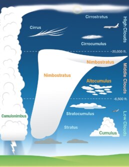
Predict Wind ☁️ Marine Meteorology ☁️ CLOUDS
- Cloud classification and cloud types
- Cloud formation
- Impact of low-level clouds on surface winds
- Impact of clouds on sailing
Introduction
Clouds are great visual indicators of atmospheric conditions and upcoming weather changes. This article begins by explaining different cloud types and their names, helping you identify clouds when you see them in the sky. We then explore how clouds form and their influence on surface winds. Finally, we examine real-world examples of how clouds impact sailing.
-
GET YOUR DATA HUB NOW AND INTEGRATE IT WITH THE NEW PREDICT WIND ANCHOR ALARM

MUST SEE ALONG THE OCEAN POSSE ROUTE
CADIZ 🇪🇸 SPAIN
⚓ 1. El Teatro Romano de Cádiz (Roman Theatre)
• Era: 1st century BCE
• Discovered in 1980, this Roman theater speaks to Cádiz’s importance as a port in the Roman Empire (then Gades). Romans developed it as a commercial and naval base.
⚓ 2. Castillo de San Sebastián & La Caleta Anchorage
• Location: On a small island at the end of La Caleta beach
• 1706 (fortress), with earlier watchtower ruins
• This fort guarded the northern approach to Cádiz and served as a key element of the city’s coastal defense system.
• Classic coastal fortification visible from sea—offering protection to fleets and warning to foes.
• Anchoring Tip: While anchoring is generally restricted, La Caleta offers a dramatic shoreline with the fortress on one side and Castillo de Santa Catalina on the other—classic “arrival in the old world” vibes.
⚓ 3. Museo de Cádiz
• Houses Phoenician sarcophagi, Roman relics, and maritime artifacts that tell the story of Cádiz’s role in Mediterranean and Atlantic trade.
• Offers a visual record of Cádiz’s evolution from a Phoenician port to a Spanish imperial launchpad.

⚓ 4. Plaza de España & Monument to the 1812 Constitution
• Cádiz hosted Spain’s liberal 1812 Cortes (parliament), while under siege by Napoleon. The constitution emphasized freedom and was a product of maritime trade-fueled Enlightenment ideals.
⚓5. Torre Tavira & the Camera Obscura
• Why It Matters: The 18th-century watchtower was Cádiz’s original maritime lookout. Today it still offers 360° views of the harbor, coast, and historic city—a practical and symbolic high point for sailors.
⚓6.Naval and Maritime Legacy
• Cultural Echoes: Cádiz was once the capital of the Spanish Navy. The city still hosts the Spanish Naval Academy, and maritime pride runs deep. Ask around—locals love sharing stories of shipbuilding, trade winds, and conquest.
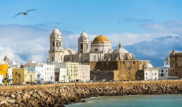
⚓.7 Old Town (Casco Antiguo)
• Vibe Check: Narrow streets, historic seafarers’ houses, tapas joints, and lively plazas.
• For Sailors: Stock up at Mercado Central, grab a Galician octopus dish, and feel the city’s deep maritime roots—this is where Columbus sailed from on multiple voyages.
Founded by the Phoenicians around 1100 BCE as Gadir, Cádiz is widely regarded as the oldest continuously inhabited city in Western Europe. Its location on a narrow spit of land in southwestern Spain made it a natural hub for maritime trade and military strategy.
The Carthaginians used it as a naval base, and after their defeat, it was absorbed into the Roman Empire, where it thrived as Gades, becoming a wealthy port exporting garum (fermented fish sauce), wine, and olive oil.
In the Middle Ages, Cádiz changed hands between the Visigoths, Moors, and finally Christian Spain in the 13th century. Its true resurgence came in the 16th and 17th centuries, when it became the main port for trade with the Americas, replacing Seville due to its deeper harbor.
From here, galleons laden with New World silver set sail or arrived under heavy guard.
Cádiz was also the site of frequent attacks by English privateers, most famously Sir Francis Drake, who “singed the King of Spain’s beard” in 1587 by burning ships in the harbor.
In 1812, during Napoleon’s occupation of much of Spain, Cádiz served as the stronghold of Spanish resistance and the cradle of liberalism, where Spain’s first constitution, La Pepa, was signed.
Today, Cádiz remains a proud seafaring city, rich in maritime history, baroque architecture, and cultural resilience, still echoing the spirit of centuries of exploration and defense.
READY FOR CRUISING THIS FALL ?
THE WATER MAKER SEMINAR Series

Marine Watermakers Seminars Part 1 ▶
Marine Watermakers Series PART 1 JULY 10 Segment 1: Watermaker Fundamentals & Choosing the Right System

Marine Watermakers Seminars Part 2 ▶
Marine Watermakers Seminar Series Segment 2: Installation & Operation at Sea
Goal: Walk through real-world installation examples and BEST PRACTICES

Marine Watermakers Seminars Part 3 ▶
Marine Watermakers Segment 3: Maintenance, Repairs & Emergency Workarounds
Goal: Equip participants with the knowledge to keep their system RUNNING

PRESENTED BY RICH

MEET THE FLEET 🇦🇺 SY Njorth Clan
We are currently in Grenada, Caribbean and plan to leave for Bonaire at the end of June 2025, making our way to Panama for Feb 2026, for our Canal crossing, with a few stops a long the way: Curacao and Colombia. Our favourite …that is always tough. Each place has been special in its own way for different reasons. We love the sea and what better way to live than to live on the sea. It’s a great way to travel, meet new people, see new places and experience the very interesting cultures. I have learnt to relax more and while some days can be tough …its just so beautiful waking up to the view that surrounds after being gently rocked all night. Of course some nights, its not so gentle but that comes with the life.
Crossing the Atlantic, changed the way we see the world; it reminded me of how small and vulnerable we are but it also taught me to trust in myself and those around us. This is definitely a shared adventure. There is so much to learn and experience. Talking to the locals when on an island, exploring the island, all help to enhance the experience of visiting and connecting. The unexpected lesson has been living with someone 24 hours day but i really wouldn’t have it any other way. We don;t have a bucket list per se but life decide for me (maybe that is a lesson i have learnt ..sometimes you can’t get to an island or place because of the weather or whatever and u just need to accept it. U can’t go everywhere. Life is not a dress rehearsal, u have 1 chance at it …so enjoy it, with everything that it has to offer.
GRENADA 🇬🇩 INFORMATION ON THE OCEAN POSSE WEBSITE
CLARKES COURT BOATYARD & MARINA 🇬🇩 SPONSORS THE OCEAN POSSE
CLARKES COURT BOATYARD & MARINA 🇬🇩 SPONSORS THE OCEAN POSSE
https://oceanposse.com/clarkes-court-boatyard-marina/
THE ORCAS.PT INTERVIEW WITH RUI
In this recorded session from June 2025, Rui, founder of Orca.pt, shared detailed knowledge about orca interactions with vessels transiting the Iberian coast, especially near Portugal, Spain, and Morocco. These incidents, which began in 2020, typically involve orcas targeting sailboat rudders. Ruy, a lifelong sailor with a background in telecommunications, launched the Orca.pt platform to centralize real-time data and build a knowledge-sharing community. The platform now includes over 2,000 active members via Telegram and WhatsApp.
The Ocean Posse’s participation brought first-hand questions from cruising captains and motor yacht owners planning Mediterranean passages. Ruy engaged directly with Ocean Posse members, offering advice tailored to their specific vessels and planned routes. His warm, collegial tone and detailed answers gave skippers confidence and clarity.
Key takeaways:
-
Sightings vs Incidents: Orca.pt maps distinguish between simple sightings (blue) and actual interactions (red), where orcas made contact with or damaged a rudder.
-
Safety Zones: Waters shallower than 20 meters (65 ft) are considered safe—no tuna, no orcas. Deep water (500+ meters) also carries lower risk.
-
Avoiding Damage: Keep moving. Do not stop the boat. Use engines if needed. Autopilot can fail or worsen interactions—hand-steering is advised in high-risk zones.
-
Boat Differences: Motorboats typically suffer less damage due to stronger rudders and better maneuverability, though they’re not immune to interaction.
-
Unreliable Defenses: Firecrackers, sand, loud music, and “spiked” rudders have been tested with inconclusive results; many are illegal or ineffective.
-
Emergency Protocols: In Portugal, SAR does not tow—private companies charge steep fees. Spain’s SAR is more responsive. Use VHF 16 and notify nearby vessels.
Rui emphasized cooperation between sailors and scientists and invited Ocean Posse members to join Orca.pt’s Telegram channels for ongoing updates and support.
OFFICIAL OCEAN POSSE EVENTS
ANNAPOLIS BOAT SHOW 🇺🇸 MARYLAND USA
ANNAPOLIS, Annapolis Town Dock Booth VB 9
OCEAN POSSE 🇺🇸 SAN DIEGO BAY 4 DAY CRUISING SEMINARS SERIES @ SAFE HARBOR SOUTH BAY
SAFE HARBOR SOUTH BAY EVENT CENTER, CHULA VISTA, SAN DIEGO, CA
OCEAN POSSE KICK OFF 🇲🇽 BARRA DE NAVIDAD, MEXICO December 3-7 2025
MARINA PUERTO DE LA NAVIDAD, BARRA DE NAVIDAD, MEXICO
OCEAN POSSE & BEN TAYLOR STREET PARTY @ CANNES 🇫🇷 YACHTING FESTIVAL
TAQUERIA LUPITA, 72 Rue Meynadier, Cannes
GRAND PAVOIS 🇫🇷 La Rochelle – Sep. 24 2025
Gran Pavois La Rochelle, 20 Av. de la Capitainerie, 17000 La Rochelle, France
GRAND PAVOIS 🇫🇷 La Rochelle – Sep. 24 2025
Gran Pavois La Rochelle, 20 Av. de la Capitainerie, 17000 La Rochelle, France
GRAND PAVOIS 🇫🇷 La Rochelle – Sep. 24 2025
Gran Pavois La Rochelle, 20 Av. de la Capitainerie, 17000 La Rochelle, France
GRAND PAVOIS 🇫🇷 La Rochelle – Sep. 24 2025
Gran Pavois La Rochelle, 20 Av. de la Capitainerie, 17000 La Rochelle, France
GRAND PAVOIS 🇫🇷 La Rochelle – Sep. 24 2025
Gran Pavois La Rochelle, 20 Av. de la Capitainerie, 17000 La Rochelle, France
OCEAN POSSE SPONSORS
- ABERNATHY – PANAMA
- BELIZE TOURISM BOARD
- BOAT HOW TO
- CABRALES BOAT YARD
- CENTENARIO CONSULTING – PANAMA CANAL
- CHRIS PARKER – MARINE WEATHER CENTER
- DELTA MIKE MARINE SUPPLY PANAMA
- DIGITAL YACHT
- DOWNWIND MARINE
- EL JOBO DIST. COSTA RICA
- FLOR DE CAÑA
- HAKIM MARINA AND BOAT YARD
- HERTZ RENTAL CARS MEXICO
- HOME DEPOT PRO MEXICO
- LATITUDES AND ATTITUDES
- MARINA PAPAGAYO
- NOVAMAR YACHT INSURANCE
- PANAMA YACHT BROKER
- PREDICT WIND
- SAFE HARBOR SOUTH BAY MARINA EVENT CENTER
- SAN DIEGO MARINE EXCHANGE
- SAFETY ONBOARD COSTA RICA
- SEVENSTAR YACHT TRANSPORT
- SHAFT SHARK
- SUN POWERED YACHTS
- WESTMARINE PRO
- YACHT AGENTS GALAPAGOS
![]()
MEDIA PARTNERS
LATITUDES AND ATTITUDES
OCEAN POSSE FLEET 🛰️ TRACKING

This page is designed to give interesting parties an overview. For specific vessel details including their floatplan, latest updates, changes, positions and specific location related questions please contact each vessel directly. Due to privacy we do not provide vessel contact information. You may track vessels via it’s own tracker or request AIS tracking from https://www.marinetraffic.com/ please note that this is also not accurate. There are many reasons why a vessel’s position is not updated and please do not conclude that a vessel has an emergency or is in need of assistance because it has not reported in lately. Sometimes they may just want to get away from it all and not tell you where they are. It is the responsibility of each vessel to file a float and check in plan and escalation procedures.
JOIN THE OCEAN POSSE
|
||||||||||||||||||||||||||||||||||||||||||||||||||||||||||||||||||||||||||||||||||||||||||||||||||||||||||||||||||||||||||||||||||||||||||
| MEET UP @ BOAT SHOWS AROUND THE WORLD | ||||||||||||||||||||||||||||||||||||||||||||||||||||||||||||||||||||||||||||||||||||||||||||||||||||||||||||||||||||||||||||||||||||||||||
| SAVE MONEY, TIME AND REDUCE BOAT STRESS | ||||||||||||||||||||||||||||||||||||||||||||||||||||||||||||||||||||||||||||||||||||||||||||||||||||||||||||||||||||||||||||||||||||||||||
|
SWIM 🏊 THROUGH THE CANAL
The Panama Canal charges by weight — and once, a man swam through it and got charged a toll of just 36 cents.
His name was Richard Halliburton, an American adventurer who swam the entire 50-mile canal in 1928. Because tolls are calculated by tonnage, they weighed him and charged him based on his “displacement tonnage” — about 140 pounds worth.
He proudly paid his 36 cents — still the cheapest canal transit in history — and probably the sweatiest.
So yes, technically, a skinny guy in a swimsuit once used the Panama Canal as his personal lap pool.
OCEAN POSSE CANAL AGENT
CENTENARIO CONSULTING
info@centenarioconsulting.com
www.centenarioconsulting.com
Cellphone +507 6676-1376
WhatsApp +507 6676-1376

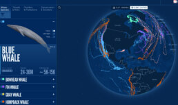
A coalition of leading scientists, civil society, governments, tech innovators and WWF have launched BlueCorridors.org. In a major advance for marine conservation, a global coalition of leading scientists, civil society, governments, tech innovators and WWF have launched BlueCorridors.org—a dynamic new platform that brings together three decades of whale tracking data with information on overlapping marine life data >>
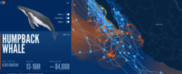

Extraordinary Cruising °°° Join the Fleet
- Access vetted local knowledge, safety resources, and prior experiences to make your passage safer and more enjoyable.
- Unlock a Life of Adventure
Explore hidden destinations, experience new cultures, and discover the freedom of life at sea or near shore – on your terms. - Get VIP Perks & Discounts at marinas, chandleries and boatyards
Get exclusive discounts, priority access, and personalized support at partner marinas across the globe. - Observe the actions of Experienced Captains
Tap into a wealth of tips, tools, and real-world know-how from seasoned mariners to grow your skills and gain confidence. - Make Every Nautical Mile Memorable
Join events, meetups, and shared journeys that turn you voyages into unforgettable stories and lasting memories. - Cruise with a Conscience
Gain insights into sustainable practices and join a movement that protects the waters you love to explore.