

CARIBBEAN LAP REPORT SV JUBEL
SV JUBEL'S CARIBBEAN LAP

SV JUBEL just finished their 1 year lap around the Caribbean. BRAVO ZULU! Here they share their story:
We are currently in progress building an HH44 Catamaran in Cebu, Philippines, which will be completed in January 2026. It's our plan to cross the Pacific to meet the boat so we can move aboard directly from JUBEL. But we didn’t come all this way from Vancouver island to skip the Caribbean. Having crossed the (Panama) Canal in September 2023, we spent some time in Bocas del Toro, the San Blas, Panama, and Cartagena, Columbia. Knowing we wanted to see the Caribbean, we decided to do a speed loop of the Windward and Leeward Islands.
The trip started from Cartagena, Colombia and we set off for Puerto Rico, or maybe the DR, on March 26th, 2024. We didn’t know where we would end up. We had heard this passage was notoriously bad, and that we may have to divert westward. So loaded with 8 extra jerry cans of diesel, we set off, along with our friends on SV VIA, a Caliber 40LRC (that holds 400+ gallons of diesel!) This trip was exactly what they say it was. We motored for 700 miles, into the wind and the waves. At times doing 3 knots. We broke our davits due to the constant slamming into the waves. We also had some flat calm days. Overall, we sailed about 10 hours out of the entire 6 days.
We ended up in Boquerón, Puerto Rico. We spent time cruising Puerto Rico for a month along the southern side of Puerto Rico, and flew home in (to Canada) in May. Our highlights are Isla Caja De Muertos, where you can hike up to the top of an abandoned lighthouse, and Isla Culebra for its snorkeling and coral farms, and of course, Costco in San Juan.

With our boat loaded with a years worth of Costco supplies in Puerto Rico we made our way to the USVI’s where it was a surprise that they drive on the opposite side of the road. We spent a few days in St. Thomas, of course, stopping at the pizza boat where we attended a massive memorial day party hosted on a catamaran while we floated in the water.

A few days on the northern side of St. Johns before making our way to the BVIs. We have a dog on board so this was pretty difficult to sort out, as you have to have a lot of paperwork and health check proofs. We met the vet in Soper’s hole where he had to inspect Ricky, our dog, in person. Once that was dealt with we made our way to pussers for a rum! This was the first island we considered “the Caribbean”, and we made it!
We spent three weeks bouncing around the BVIs including Norman Island (and the infamous Willy Ts, where we floated behind it in our Sunchill, met friends, and had beers thrown into our pool!

Anchoring at the Baths, (where our engine died coming into the anchorage, that turned out to be ricky leaning on the shutoff button!), and spending time in Virgin Gorda was also great. Our favorite anchorages were Savannah bay, and the north side of Prickly Pear Island. Having the Rum Runner bring us blended cocktails right to our boat was (also) a highlight, along with visits to Saba Rock.
From The BVIs we checked out and headed to St. Martin, stopping at the French side first. The beaches here were phenomenal. While a little run down, its very pretty, and the French food supply is amazing. We had FKG rigging come out to the boat by dinghy to give us an estimate for the standing rigging replacement that we needed. They gave us a very, very reasonable estimate and we headed over to their dock on the dutch side to have the work done. A week later, everything was brand new. Highly recommend them! We also had a new generator motor shipped here and replaced that, as our previous one had water ingress due to a manufacturing defect. St. Maarten is an amazing location for boat work and supply, especially since its all tax free. There are also great restaurants here, where we met up with some other Young Cruisers and talked shop, so we will definitely come back at some point. St. Maarten is a hit on our list!
Our next stop was Guadeloupe. It was here that we rode out hurricane Beryl. On the west side of the island behind the mountain, we set out a 10-1 scope in 20 feet of water. Luckily (for us, certainly not the islands south of us) it headed south. We were hit with 35 knots of wind and a ton of rain, but otherwise, unscathed. After the weather cleared, the view was beautiful.

We worked our way down Guadeloupe, and anchored in some very rolly anchorages - There is not much for protection on this side of the island. We stopped in several hot springs and enjoyed the natural hot water that comes out all over the island. After an absolutely brutal sail crossing from Guadeloupe to Terre-de-Haut, a group of small islands south of Guadeloupe, we went to explore and island and old fort. There is a really cute little town (but not much for food available) that you can explore.

From there we made our way to the jewel of the Caribbean, Dominica. I can not say enough about this place. It is, by far, our favourite locale in the caribbean. Absolutely untouched and unspoiled. There were no tourists, the locals were the friendliest people we have ever met, and would do anything for you. The natural beauty of this island is absolutely stunning.Waterfalls, valleys, hot springs, gorges - It has it all.

What it doesn’t have are services, restaurants, fuel docks, or supply shops. You are on your own. So bring what you need, and stay as long as you can. We grabbed a mooring ball in Portsmouth bay for $10 a night, where the PAY (Portsmouth Association of Yacht Services) will come out to the boat and give you anything you need, and help you check in. We rented a car from a local company (that we had to swap out three times because they were not in great shape - Old cars imported from Japan), they also drive on the British side of the road (in Dominica). Its like driving in the game “crazy taxi”. We drove all over the island over 5 days.


We went to visit Titou gorge where they filmed parts of the Pirates of the Caribbean

Overall, Dominica gets a 10/10 for us. We will be back to this island before our cruising career is over. Its got so much to offer, and so much that we haven’t seen, for a small island. Our provisions were running low so it was time to carry on. We made our way to Martinique from here, where we knew we could provision. And provision we did. Wine, cheese, butter, oh my. The French have food nailed down. We were here during a summer festival and I have never seen so many boats on the move, ever.

Martinique was the busiest place we’d ever been. The bays were full, with hundreds if not thousands of boats. It was way too busy for us. And they’re very not dog friendly. So after we provisioned, we carried on down to Grenada. We skipped St. Lucia for safety concerns, and therefore had to skip St. Vincent and the Grenadines due to our dog and rabies rules. That, and its been hit hard by Beryl at this point.
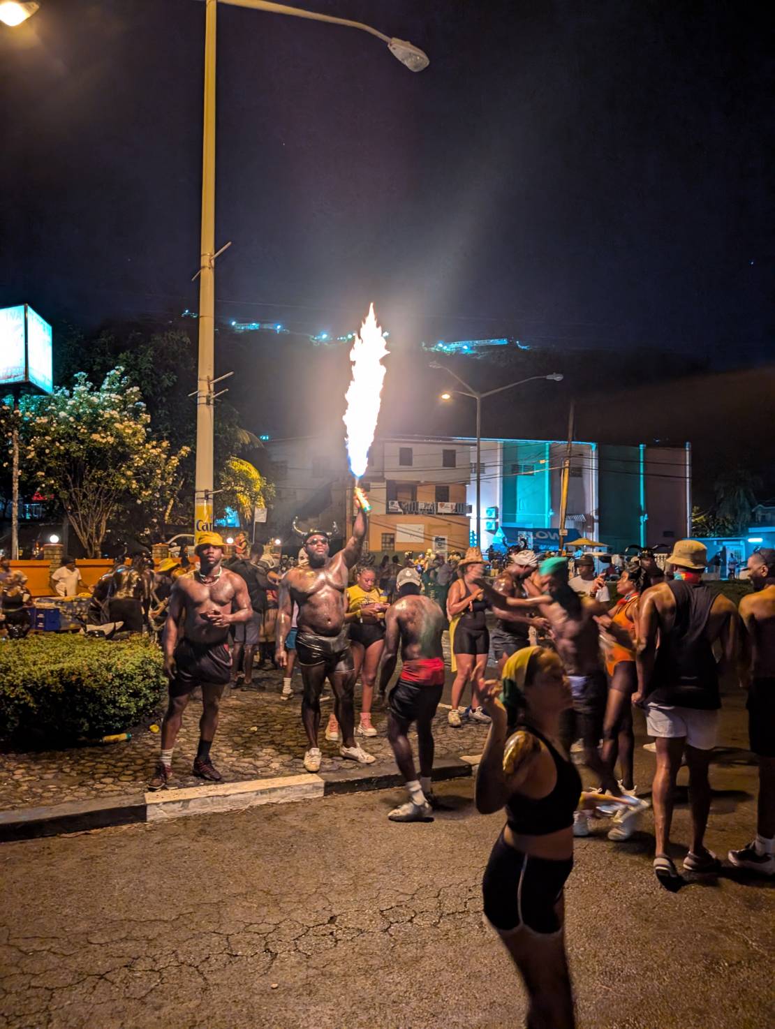
Grenada became our home for about a month and a half while we waited for hurricane season to subside slightly. The next stop after this was Bonaire, so hurricanes weren’t a big concern. We met up with friends, enjoyed copious wing nights, went snorkeling, and hauled out because we had won a free haul out from Spice Island Marine at the Young Cruisers Association Cruisers Awards. We were here for Carnival which was amazing.

We had tried out all the anchorages and there was a weather window coming. It was September at this point, so it was time to carry on to Bonaire. After a sporty 3 day sail downwind (oh how nice it was to go downwind finally, after beating our way east all the way to Dominica), we arrived in Bonaire. The water clarity blew our minds.


However, the lack of Starlink was frustrating after having it for so long. So back to a cell phone data plan we went, we spent our days snorkeling and swimming. We rented a car and drove around the whole island, stopping to feed the roadside donkeys apples and carrots.

Bonaire was definitely another highlight. The freediving and snorkeling is amazing. Its everything its cracked up to be.
We skipped Curacao and headed to Aruba to meet friends and for my parents to fly in. We loved Aruba - Dove on a shipwreck, swam with turtles, went out to fantastic restaurants, played some slot machines, had some pool days at the Hyatt pool, and even found a Canadian bar that had Poutine and took Canadian money!
Now here we are in Cartagena once again, having crossed our track when we left 8 months ago, so very happy we traveled where we did and saw what we saw. The experiences will stick with us forever, and we hope to go back to some of the islands once again in the future. Now, its time to go back to San Blas one more time before we prepare for our grand adventure across the Pacific!
SY JUBEL 🇨🇦 Leah & Kyle - Gulfstar 44'

THANK YOU FOR SHARING YOUR HIGHLIGHTS FROM YOUR 8 MONTH CARIBBEAN LOOP


POSSE PERK: Free vessel and fleet tracking courtesy of Predict Wind
POSSE PERK: 🛰️ Free vessel and fleet tracking courtesy of Predict Wind
https://oceanposse.com/tracking/
Ocean Posse Members: Sign Up your vessel for free tracking:
ADD YOUR VESSEL TO THIS FLEET TRACKING PAGE >> |
For Help and to review the different options :
TECHNICAL SUPPORT ABOUT THE FLEET TRACKING PROCESS >>
About Fleet Tracking:
Tracking is designed to give interesting parties an overview of where vessels may be on their voyage. For specific vessel details including their float plan, latest updates, changes, positions and specific location related questions please contact each vessel directly. If you are on passage all of us and the fleet can monitor your progress.
![]()
*The Ocean Posse is not responsible for the accuracy, frequency or validity of any individual vessel's report. This report is not necessarily accurate. Due to privacy we do not provide vessel contact information. To more accurately track vessels via it's own tracker or request AIS tracking from https://www.marinetraffic.com/ please note that this is also not accurate. There are many reasons why a vessel's position is not updated and please do not conclude that a vessel has an emergency or is in need of assistance because it has not been reported lately. Sometimes they may just want to get away from it all and not tell you where they are. It is the responsibility of each vessel to file a float and check in plan and escalation procedures.

PDF SAFETY UPGRADES
PDF SAFETY UPGRADES
By Rob Murray on SV AVANT

Aboard SV Avant, we’re bullish on PFDs. We wear them whenever on deck while underway, and have upgraded them with a few additional gewgaws to help them (pretty much) match ORC safety guidelines and increase their effectiveness. We regularly (annually) look over the Offshore Racing Congress (ORC) guidelines and update our safety gear accordingly.
Your PFD is your primary piece of personal safety gear, and is what will keep you afloat should you slip overboard. Being rescued by the short-handed crew you leave aboard might not be instant, so being prepared to signal and help them find you is likely to be very useful. Having your PFD kitted out to make it more effective than what comes off the shelf is easy, and (we think) worthwhile. Having a few of the nice-to-have-at-hand items on your person is good too, so we add those as well.
We follow the ‘one is none, two is one’ ethos in equipment – if something is important, we like to have a spare or alternate item immediately at hand.
We start with a basic, automatic inflatable PFD with an integrated harness for offshore use. If you’re sailing in your home jurisdiction and want to use it to meet safety regulations, you need to pay attention to local government approvals, but if you’re offshore or going offshore, we feel any approval is good enough to meet the use case (Canadian Coast Guard, US Coast Guard, UK Maritime and Coastguard Agency, European CE, etc.). There are a lot of manufacturers (Crewsaver, Mustang Survival, Revere, Spinlock, Stearns, and many others) and when you look them over, they’re much of a sameness in features and approvals. We buy what’s on sale.
We replace PFDs every 5-6 years and rotate the used ones to spare status, and after 10+ years, they’re binned. We inspect them when they come into inventory as new, and annually thereafter. Annual inspection is visually checking for wear spots, frayed stitches, etc., cleaning and servicing the stuff attached to them, changing batteries in battery powered accessories, and then inflating the life vests and leaving them inflated overnight to check for loss of pressure (leaks) before refolding them for use.
Our Upgrades
Start with a basic, integral harness, self-inflating PFD.
We add what the ORC calls ‘ride up prevention system (RUPS)’. These can be either thigh straps or a crotch strap. We use crotch straps as we have found them easier to use, they have lower drag, and are cheaper than thigh straps. These prevent you from slipping down in the life vest (or the life vest slipping up on you) and make it easier to keep your head above water. If you’ve ever tried your life vest in the water, you will know the importance of having a RUPS.

We add a knife. The knife should be easy to open (and close), and somehow attached to the PFD so it won’t be lost. A belt clip allows it to be clipped to the PFD waist strap for storage. You can make a string lanyard, but we prefer elastic tethers, which we get at the Dollar store (our favorite chandlery). These tethers last a few years before needing replacement. The knife should be at least ½ serrated (for fast cutting) and have a blunt tip or sheepsfoot blade (so it’s harder to inadvertently puncture the PFD bladder with it). A cheap West Marine rigging knife works fine, or a Spiderco Salt if you want an upgrade. If you get a sharp-tipped knife, grind off the pointy tip. Any knife will rust, so we brush ours liberally with wax (like we use on the hull) using a toothbrush and wipe the excess off, which seems to keep rust at bay.
Many PFDs come with a whistle stowed inside the folded bladder. If not provided, add a whistle there. We add a second one outside on a coiled elastic strap around the bladder so it can be used to call up off-watch crew, or signal a nearby boat instantly, without opening the life jacket. The low profile Fox whistles are good for this.

We think you should have a light (minimum 1). We have two (three counting the headlamp). We have one automatic light inside on the inflation tube, and a second one outside on the same coil elastic as the exterior whistle. The interior stowed light is a water-activated strobe. The exterior light is a simple, pocket LED powered by 2032 lithium coin batteries; these are often sold as bike lights. It provides enough light for tasks right at hand, can light your way forward on deck, help you find that thing you dropped, etc. They’re usually available in white or red, and we choose red to try to preserve night vision. We rub a bit of Vaseline on the o-rings when we change the batteries every year. For devices that use AA, AAA, or similar batteries, we use lithium batteries for longer life, better cold weather performance, and less chance of a leaking battery.
For our offshore jackets, we upgraded and use McMurdo MOB-1 Beacons. These have a light, a DSC-VHF alert with an AIS transmitter, and are rigged to go off when the jacket inflates. The beacons alert the mother ship and nearby vessels of a crew overboard situation via both DSC-VHF and AIS. There are other devices that have AIS transmitters without the DSC, and also PLBs (personal satellite beacons). We chose the DSC-VHF+AIS beacons because not everyone has AIS, but DSC-VHF is becoming ubiquitous. PLBs are great but take longer to alert anyone, and they send their alert to a coast guard station thousands of miles away, not to boats on the scene (if single handing, the PLB would be the way to go, though).
Our previous generation alerting devices were McMurdo Smartfind S20 AIS MOB Beacons (which seem to be discontinued now). These transmitted a GPS location on AIS and were good, but we prefer the dual DSC(VHF) and AIS functions the new beacons offer. The old ones are relegated to our backup systems now. These all need periodic servicing just like an EPIRB does.

We also add a signal mirror. These are inexpensive, and provide an alternative long range (up to 20 miles) signalling capability. You can get them in outdoor camping shops. We attached them to the inflation tubes with simple string neck lanyards for cell phones from those favorite chandlers, the Dollar store.

We like a headlamp right at hand (it does get dark, pretty much every night), so we add one to a pouch on the belt. If the pouch is zippered, we treat the zipper with wax (like lip balm, also from the Dollar store) to keep it working. Our preference is for waterproof ones with variable output and red light capabilities. You don’t need much light working on deck at night, and bright white ones will ruin your night vision. These can be used to signal as well, should you need to.

We like to have a multi tool at hand at all times – a Leatherman™ (or similar) with pliers, screwdriver bits, and so on. We keep it in a pouch on the PFD belt. If you find something loose and want to tighten it up, it’s convenient to have the means at hand when you discover the issue and save a trip downstairs to grab a tool. The multi tools are also prone to rust, so we treat them the same way as the knife, with an annual liberal brushing of wax, wiping off the excess.

We like to upgrade the reflective tape(s) on the PFD’s bladder. They usually come with a couple of meager-meets-minimum strips of reflective tape, so we add three or five more around the upper edges to increase visibility. If you’re buying reflective tape, get a roll so you can upgrade your LifeSling, Man Overboard pole float, life ring, and other safety gear too.

ORC rules also call for each PFD to be marked clearly with the wearer’s or boat’s name: a few seconds with a Sharpie™ and that’s crossed off the list as well.
With a few changes in how you add, stow and use safety gear on your PFDs, along with a bit of attention, you can make any PFD a more useful survival aid, and the additional weight isn’t really noticeable when in use.
SY AVANT 🇨🇦 Rob & Debra – Beneteau 43.5

French Polynesia Long Stay Visa Procedure
French Polynesia Long Stay Visa Application:
It's a Process not Rocket Science
By Maurisa Descheemaeker on SV WHIRLWIND

The best place to start getting familiar with the procedure is on the French governments visa wizard landing page: https://france-visas.gouv.fr/en/visa-wizard On the visa-wizard page you enter in your nationality, your destination, and plans in said destination. In short you will find that with the exception of:
- Citizens of the European Union, Monaco and Andorra, for all territories.
- Citizens of the European Economic Area (EEA) and Switzerland, except French Polynesia, New Caledonia, Wallis-et-Futuna and the French Southern and Antarctic Lands (TAAF)
all citizens wishing to stay in French Polynesia for more than 90 days must apply for a long-stay visa BEFORE arriving in French Polynesia. Anywhere there is a French Embassy one may apply for a long-stay visa for French Polynesia. We were planning to set sail from Panama so we had our application appointment in Panama City and said as much on the application. As a US citizen with plans to cruise in French Polynesia for more than 90 days the wizard determined that I needed to apply for a long-stay visa and then directed me to the online application link. In this link you create an account with a username and password. You may then access, fill out, and submit your application. Once the application is submitted you can book an appointment to go in person to the embassy to present yourself, your application and all required supporting documents.
Honestly, with all the information from well intentioned cruisers on the internet about the process and all the changes over the years I felt mixed waves of uncertainty before I started the application. I quickly realized that .he path to the Long-stay visa is a process not rocket science. My waves of uncertainty were more of a mental block than an actual challenge because once I got started with the application I found the process very straightforward albeit a bit tedious. Furthermore, any time I had a question I wrote directly to the embassy in the country I was applying from. The response was very quick and very clear. Asking the embassy directly was very helpful because the rules were one way before COVID, another way during COVID, and another way still since COVID. The process and requirements have and may still be changing so the best source of information is the government agency directly.
That said, there were a few questions that felt like wild cards that actually were not because upon asking I was given black and white responses:
- There is a question of when to apply: Each embassy has different processing times so ask directly. Panama told me 4-6 weeks and they were. It is important to note that you cannot apply more than 90 day before your expected arrival date.
- There is a question of when you will arrive: Our best guess was provided. We arrived a month later and this was fine. You basically have the duration of your visa to arrive.
- There is a question of providing your passport for review: Different embassies have different requirement regarding passports. Some require looking at it and scanning it immediately, some hold it overnight or more. Ask ahead so you know what to expect. We provided a letter stating that we needed to hold on to ours and this was acceptable.
- There is a question of who is applying: I was applying for myself, my husband, and our two kids. This is very easily done in the online application by stating that I was 'travelling in a group' so I just added people to my one application instead of making four applications.
- There is a question of an address: I am a citizen of the United States and provided my address in the US. Regarding an address in French Polynesia I stated that I planned to be cruising. I would be living about my vessel everywhere I went. This was true and fine. I stated the Island groups I planned to visit.
- There is a question of health coverage: I asked the embassy exact what the minimum requirements were and found a plan that met or exceeded them.
- There is a question of socio-economic status: I asked the embassy exactly what this meant she replied that: Socio-economic status would be for example retired/employed/company owner etc, which you need to show proof of.
- There is a question of funds: I asked the embassy what the minimum requirement was. In January 2023, when we applied the requirement regarding the funds was that you had to prove that you had or have coming in an annual amount equal to 12 times the amount of the monthly minimum wage in France (currently 16,784.32€) per adult. This would certainly be something to ask specifically about as minimum wage changes. They ask that proof of the funds is by presenting the last 3 months of bank statements preceding your application appointment. These can show monthly income equal to monthly minimum wage or a balance holding the annual income stated above.
After I made my way through the online application successfully, I was then able to make an appointment to present everything in person at the embassy. The in person appointment is when we provided our passports, extra passport photos, printed and signed applications, all supporting documents, and the processing fee in cash. The supporting documents I provided included two separate letters in English and French (using Google Translate): one stating that I had no plans of seeking employment in French Polynesia (this does not exclude me from working remotely for a US company as revealed in the question of funds on the application) and one stating that I homeschool my children. I also provided a document from my school superintendent my kids status as enrolled homeschoolers, our marriage license and birth certificate copies for each of our kids.

In Panama, the French Embassy is located on a lovely point in Casco Viejo. After the Visa appointment we took the afternoon to enjoy Casco Viejo which was a lovely treat! Then we waited the 4-6 weeks to hear back via email that our visas were approved. We then made yet another appointment to return to the French Embassy with our passports to get our visas, and enjoy another afternoon in Casco Viejo.
Again, every French Embassy in each country may have slightly different protocols. Check with the Embassy directly to know exactly what they require so that your efforts to secure a long-stay visa in French Polynesia are smooth and easy.

FLEET UPDATE 2024-11-03
|
|
|
|
|
|
|


|
|
|
|
|
|
|
|
|
|
|
|
|
|
|
|
|


|
|
|
|
|

|


|
|
|
|
|
|
|


|
|
|
|
|
|
|
|
|
|
|
|
|
|
|
|
![]()

PASSAGE REPORT: SAMOA TO WALLIS ISLAND
SV VIVA SHARES PASSAGE REPORT:
SAMOA TO WALLIS ISLAND


VESSELS ARE GETTING A JUMPSTART ON CRUISING SEASON ON THE PACIFIC COAST
VESSELS ARE GETTING A JUMPSTART
ON CRUISING SEASON IN MEXICO, COSTA RICA, & PANAMA

SY PERCEPTION 🇺🇸 Jim & Melinda & Grace - Lagoon 42'


SV ZORBA  Tomer & Limor – Tayana 48’


FAIR WINDS

SOUTH PACIFIC TROPICAL CYCLONE SEASON OUTLOOK
SOUTH PACIFIC TROPICAL CYCLONE SEASON
NOVEMBER 1-APRIL 30
NEW OUTLOOK RELEASED
Tropical cyclones, like hurricanes, are known for their powerful winds, heavy rains, and potential to cause significant destruction. Tropical cyclones frequently affect the southern Pacific and can pose serious threats to both public health and infrastructure. All vessels are advised to have a plan of action for the cyclone season.

According to New Zealand's National Institute of Water and Atmospheric Research (NIWA) and Metservice, the South Pacific may see either fewer or a normal number of tropical cyclones this season. The cyclone season in the South Pacific starts November 1 and runs until the April 30, with the typical 'peak' of the season being January - March. The outlook that has recently been released, "Southwest Pacific Tropical Cyclone Outlook - October 2024" describes a slower start to the Cyclone season, potentially less cyclone risk overall in the eastern region while potentially elevated risk in the western region. According to the NIWA Outlook, "As of early October 2024, sea surface temperatures across the eastern and central equatorial Pacific Ocean are below average and close to La Niña thresholds." Forecasters are observing more La Niña-like characteristics that tend to reduce risk in the east and elevate risk in the west where warmer water may 'stack up' later in the season. As with many weather outlooks of late there continues to be caution that while there may be less risk in the frequency of tropical storms this season, there is still a risk that those that come may intensify more rapidly or simply be very intense.

For cruisers in French Polynesia South Pacific Posse member Scott on Tartaruga shares:
What is critical to following storms in FP is the location of the MJO. Madden Julien Oscillation. You can research that but when that is over French Poly that is when the highest probability of big storms occur. Per some local Tahiti sailors they almost never have any cyclonic storms outside of MJO events. This last season Fiji announced the MJO forecast and when it would be over FP and boom the storms came. Also note that Fiji is the official metrological organization for these storms. Another important data point is they name their storms very early, mean the wind scale starts at a much lower number....NOAA tracks (the MJO) closely as well. I would educate yourself on how to read the graph. It is a bit strange.
Fiji Meteorological Service Regional Specialized Meteorological Centre Nadi-Tropical Cyclone Centre also just released a forecast on the upcoming tropical Cyclone season. Their predictions are similar.

Stay alert on great weather sites including:
- https://www.met.gov.fj/index.php?page=tcoutlook
- https://niwa.co.nz/climate-and-weather/southwest-pacific-tropical-cyclone-outlook/southwest-pacific-tropical-cyclone-outlook-october-2024

MEXICO ENTRY AND EXIT REQUIREMENTS
MEXICO ENTRY AND EXIT REQUIREMENTS
FOR FOREIGN FLAGGED VESSELS

- Paperwork and fees for the people (and animals) onboard the vessel.
- This involves getting tourist visas through Immigration and going through customs. Visitors need to provide their passport, crew list, and vessel documentation.
- Paperwork and fees for the Vessel to obtain a TIP.
- TIP’s are temporary Import Permits that boat owners apply for and pay for upon entry into Mexico. Captains present vessel and ownership documentation for permit. The TIP is on the vessel and the ownership of the vessel is unimportant. The fee is less than $100 and yet the paperwork associated with it is the vessel’s Golden ticket into Mexico. TIP’s for foreign flagged vessels are valid for ten years in Mexican waters. Foreign vessels are meant to cancel their TIP upon exiting Mexican waters.

When a vessel leaves Mexico without cancelling their TIP and this same vessel tries to enter Mexico complications arise. In recent years, one of the biggest challenges cruisers entering Mexico have faced is discovering that their vessel has an uncanceled TIP. If a vessel is found in Mexico without their ‘Golden Ticket’. The vessel can be impounded immediately. Only fees, paperwork and stress build in this scenario.

POSSE PERK: WEEKLY LIVE CALLS WITH LOCAL WEATHER REPORTS
POSSE PERK: WEEKLY LIVE CALLS WITH LOCAL WEATHER REPORTS
☎️ Free Weekly live calls on Mondays via dedicated LINE.me group
The Ocean Posse has weekly, live, in-season calls dedicated to five different regions where posse members are cruising:
- The Pacific Americas Route (Beginning October 28 through June)
- The Caribbean Route (Beginning October 28 through June)
- The Atlantic Route (Beginning October 28 through June)
- The Mediterranean Route (Beginning October 28 through June)
- The South Pacific Route (In process now ending November 4th)

During the Weekly calls members join in to:
- Share any emergency or emergency relay needed
- update one another on location, any issues they may be having, or fun stuff they are doing
- Receive weather report from Captain Dietmar
- Questions people have for one another.
This weekly communication is a a little bit like a net and fulfills all the same functions.