

SEASON 8 AWARD ENTRIES: GALLEY GODDESS
SEASON 8 AWARD ENTRIES: GALLEY GOD OR GODDESS
*Warning: All Galley Goddess Entries will make your mouth water...Enjoy
Lance from SV QUESO GRANDE II is hereby nominated for a Galley God award entry for successfully manning the BBQ pit with a special rub at Yacht Port Cartagena .

SY QUESO GRANDE II 🇺🇸 Lance & Sherri - Seawind 41'

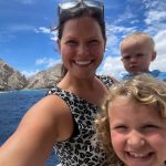
Mary from MV MARTINI says:


MV MARTINI 🇺🇸 Mary & Bryan - Nordhavn 64′


THANK YOU FOR SHARING YOUR ENTRIES AND NOMINATIONS!
OCEAN POSSE IS ACCEPTING SEASON 8 AWARD ENTRIES:
SUMBIT YOUR ENTRIES OR NOMINATE A FRIEND.
SEND PHOTOS TO MAURISA AT EDITOR@OCEANPOSSE.COM
OCEAN POSSE SEASON 8 AWARD CATEGORIES:
BIGGEST FISH CAUGHT*
PICTURE OF THE YEAR
YODA OF THE YEAR
SPEEDY AWARD – SEVENSTAR AWARD
THE CAPTAIN RON AWARD
MOST UNWELCOME VISITOR ONBOARD
HIGHEST WIND RECORDED
SPIRIT OF EXPLORATION
GALLEY GOD(ESS)
GOOD SAMARITAN OF THE YEAR
BOAT YOGA POSE OF THE YEAR
COURAGE AWARD
SAND CASTLE AWARD


FLEET UPDATE 2024-09-08
|
|
|

|
|

|
|
|


|


|

|
|

|
|
|

|

|

|

|


|
|

|

|

|
|

|


|
|


|
|

|


|
|


|
|
|


|

|
|


|
|
|


|
|


|


|
|

|

|

|
|


|


|


|

|


|


![Hurricane Beryl (/ˈbɛr.əl/) was a deadly and destructive Category 5 Atlantic hurricane that impacted parts of the Caribbean, the Yucatán Peninsula, and the Gulf Coast of the United States in late June and early July 2024. It was the earliest-forming Category 5 hurricane on record and the second such storm in the month of July, the other being 2005's Hurricane Emily. Beryl was also the strongest hurricane to develop within the Main Development Region (MDR) of the Atlantic before the month of July. The second named storm, first hurricane, and first major hurricane[nb 1] of the 2024 Atlantic hurricane season, Beryl broke many meteorological records for the months of June and July, primarily for its unusual location, intensity, and longevity.]( https://oceanposse.s3.us-east-2.amazonaws.com/wp-content/uploads/2024/09/08/content_047.jpg)

|


|
|

|
|
![]()

STORIES FROM DISTANCE SHORES
STORIES FROM DISTANT SHORES

Steve, from SV Wine N Down, has had many sailing adventures. He did a loop from Fort Lauderdale to the Caribbean, the Leeward / Windward Islands, Grenada and back. Then he sailed to Mexico, Belize, Panama to the San Francisco Bay. Now he is off anew on another voyage. Here he shares about their new adventure:
We are happy to be back out to sea. Our current trip so far: Right now, my three buddies and I are on a fishing adventure. Our lady friends/wife’s are flying in and meeting us at different locations throughout our planned four trips.
- Trip one will include our departure from SF on September 1 and ending in Long Beach. I need to return to Sonoma temporarily for grape and olive harvest time.
- Trip two will take us to La Paz, Mexico, with lots of fishing planned.
- Trip three will take us across the Sea of Cortez, with many stops along the way.
- Trip four should put us in for a stop in Puerto Vallarta and with a final home base in Barra de Navidad by around February 1st.
The adventure continues.


Steve says, “It’s all about taking our time and enjoying everything about cruising and enjoying our beautiful planet.”
SV WINE N DOWN 🇺🇸 Steve & Crew – Leopard 58′

THANK YOU FOR SHARING YOUR JOY STEVE!
Ocean Posse Members, please share your stories by sending them to editor@oceanposse.com.
Maurisa, the editor, is always happy to receive your stories and share them out. Together we can inspire one another!

SEASON 8 AWARD ENTRIES: MOST UNWELCOME VISITOR
SEASON 8 AWARD ENTRIES: MOST UNWELCOME VISITOR

MY NEXT CHAPTER 🇺🇸 Chris & Shawna & crew – Selene 59′

SY REMEDY 🇺🇸 Natalie & Karl – Leopard 45’


SY ROXXY 🇺🇸 Dennis & Kelly – Beneteau 52’


SY MAISON DE SANTÉ 🇺🇸 Nicole & Keenan- Cal 46′


SV 🇺🇸 WINE N DOWN Steve – Robertson and Cane 58′
THANK YOU FOR SHARING STEVE!
OCEAN POSSE IS ACCEPTING SEASON 8 AWARD ENTRIES:
SUMBIT YOUR ENTRIES OR NOMINATE A FRIEND.
SEND PHOTOS TO MAURISA AT EDITOR@OCEANPOSSE.COM

OCEAN POSSE SEASON 8 AWARD CATEGORIES:
BIGGEST FISH CAUGHT*
PICTURE OF THE YEAR
YODA OF THE YEAR
SPEEDY AWARD – SEVENSTAR AWARD
THE CAPTAIN RON AWARD
MOST UNWELCOME VISITOR ONBOARD
HIGHEST WIND RECORDED
SPIRIT OF EXPLORATION
GALLEY GOD(ESS)
GOOD SAMARITAN OF THE YEAR
BOAT YOGA POSE OF THE YEAR
COURAGE AWARD
SAND CASTLE AWARD

POSSE PERK: 📹 Free Video EDUCATIONAL Seminars
POSSE PERK: 📹 Free Live & Video
EDUCATIONAL
Navigation Software Open CPN Seminars

A huge Posse Perk is access to both live and recorded seminars on a variety of relevant cruising topics. Of particular relevance are the navigational seminars related to using OPEN CPN for navigation. Open CPN allows you access to multiple views (from different satellite views to different charts) of one location in one location. One can plan routes and load in weather files among other capabilities. There is a lot to learn in order to use Open CPN to it's potential which is why the Ocean Posse offers educational seminars.
LIVE Navigational Cruising Seminars coming up in San Diego:
- Open CPN - installation and integration (PC + MAC )
- Weather Weather Weather – planning – routing – underway
- Open CPN – Satellite Charts – Use Cases and Satellite Chart creation
- Chart Accuracy, Navigation Trips and Tricks & Tracking
Navigational seminars currently available to Ocean Posse members online:
- OPEN CPN MAKE CHARTS
- CREATE .MBTILES WITH SASPLANET
- OPEN CPN WITH ROB FROM AVANT OCT 23
- ADVANCED SAT2CHART: MAKE GOOGLE EARTH CHART OVERLAYS WITH PAUL HIGGINS
- OPEN CPN USE CASE
Posse members can click on this link to log into the site to view all these and more.


POSSE PERK: ⛵ In a Community of Voyagers we Create Lifelong Friendships
POSSE PERK: ⛵ In a Community of Voyagers we
Create Lifelong Friendships
“We are all travelers in the wilderness of the world, and the best we can find in our travels is an honest friend.”
– Robert Louis Stevenson


Sailing to Mexico from the Pacific Northwest: Hazards and Resources
Sailing to Mexico from the Pacific Northwest:
Hazards and Resources
By Rob and Debra Murray from SV AVANT as previously published in Currents Magazine

About the Hazards
As you set out on your sail to Mexico from the Pacific Northwest, there are numerous hazards you will encounter. For most, the only defense is a good watch.
Fishing Boats
Most vessels inshore are commercial fishing boats, and many do not use AIS, so other fishermen don’t know where they are fishing. At night, they usually light up like stadiums hosting a World Cup game and are easy to spot. They tend to congregate on offshore banks or directly offshore from ports on the coast. Some fishermen have begun using AIS beacons on fishing gear, which is a bonus.
Debris
Floating debris, especially logs, can be an issue, particularly during or immediately following heavy rains or large tides, and especially off of larger rivers or inlets.
Crab Pots
Crab pots are endemic. While there has been an effort to create a crab pot free zone down the coast, its observance is marginal and equipment drifts into the the lanes anyways. The consortium that manages the lanes hasn’t met to update the agreement since 2017. Note that in areas subject to strong current, commercial crabbers will generally use two buoys, one to hold the line up and a second on a further 10 feet or so of line that will still be visible and retrievable, even when the first buoy has been pulled under by the current. It’s easier to tangle a buoy in your prop if the current is slack and both buoys are lying idle on the surface.
Bars
Of course, everyone worries about the dreaded ‘bar crossings’ that may be encountered. After all, they do call the Columbia Bar the ‘Graveyard of the Pacific’, right? But if you’re crossing at a slack or flood in weather that isn’t horrible, none of the bar crossings are difficult. In Avant’s passage down the coast, we entered Astoria (the aforementioned ‘graveyard of the Pacific’), Coos Bay and Humboldt Bay/Eureka (widely considered the second worst bar crossing), and had no trouble at all. Our timing had us arriving at each bar on or near slack water, with a slight edge to the flood tide. Many mariners recommend using the last of the flood tide as the optimum time for a bar crossing, when the water is deepest. Waves at each entrance were under two feet, and the period was long, as predicted by the forecasts we sailed under. Charting was universally excellent.
Each harbour with a bar has a coast guard station that can offer advice, an up-to-the-minute bar report, and will even send out a cutter or other boat to guide you in if conditions warrant (we availed ourselves of this at Coos Bay when visibility dropped to under 200’). If you get caught out by a closed bar, you just have to gut it out until the bar reopens, but with modern weather forecasts and a modicum of planning,
this is highly unlikely. (Note that the coast guard definition of a ‘small craft’ in bar closing advisories is a vessel under 65’ in length.)
Available Resources
The following resources can make this specific passage more pleasant and perhaps less challenging:
Weather Information
No doubt you have attended courses, read books, downloaded software, studied weather patterns, learned how to download a variety of GRIBs, receive weather faxes, decode 500mb charts, toss chicken bones and generally worked really hard to prepare for cruising by becoming your own expert weather forecaster. Well, on this trip, those skills can be used for entertainment value or simply allowed to rest. (Don’t worry, you will use those skills south of the USA/Mexico border).

The NOAA forecasters are as good as it gets, and there are dedicated teams in each of Washington, Oregon and Northern California working around the clock to deliver the most accurate weather forecast possible. These forecasts are available via VHF on the usual WX channels to a considerable range offshore (usually at least 50 miles, often 100+). The forecast zones extend to 250 miles offshore in discrete steps, and the forecast zones are quite small. In addition to the forecast, each weather office provides a ‘discussion’, which underscores the reasons for the forecast offered, how the models informed (or did not inform) the forecasts, what’s likely to follow the forecast period, and any other juicy tidbits the forecaster(s) think might be interesting. You can find the discussion by going to the forecasting office’s webpage and looking for the ‘discussion’ button.
If you want to ‘play along’ with the forecaster, you can download the GRIBs (GFS and NDFD editions) and see if you get the same conclusions.
Live and near live weather observations are also available from the national weather service by finding the ‘observations’ button on the left side of the forecast page. These vary in frequency from every few hours to live, depending on location and observation station type. There are dozens of these between Neah Bay and San Francisco.
Enjoy the weather forecasts. They end at the Mexico USA border and it becomes far more basic there.
Wave Patterns
Waves offshore contribute substantially to the (dis)comfort the crew experience on the passage. Aboard Avant, we have found waves change character at depths of about 60m/200’. When the depths we sail in are under 60m, the waves seem to have a different character, a more insistent vertical component, than they do in greater depths. We always aim to be in depths greater than 60m/200’ whenever possible. When closing the coast, expect waves to ‘feel’ stronger, even if they are not visibly any bigger. Also when closing the coast, watch for secondary wave trains from reflections off shorelines where the shores are steep to, or a change in wave direction where a wave train may wrap a point or headland. And there are also outliers such as this one.
Generally, wave height has very little to do with discomfort aboard; it is the ratio of wave height to period that creates difficulty. When waves are ‘square’ (wave height in feet = wave period in seconds), no one will have any fun aboard, whether the waves are 3’ or 8’ high. We choose not to sail in square waves. When the period extends to 1.5x the wave height, conditions become much more tolerable. When the period is 2x or greater wave height, the gentle rise and fall is barely noticeable after a while.
When traveling with the wave train, the apparent period will be longer, and when traveling against the wave train the apparent period will be shorter. Take this into account when evaluating wave predictions.
Guidebooks
The NOAA Coast Pilot 7 is a free download and covers the coast from Neah Bay to the Mexican border. You will want to read chapter three, and use chapters seven to thirteen in reverse order as you transit south. This volume, over 700 pages, is a comprehensive mariners guide to the coast, its character, and its hazards. It is updated weekly, so make sure you have the latest edition downloaded.
There are commercial cruising guides available for the Columbia River and San Francisco Bay, but we found they added little to what the Coast Pilot provided for free.
The USCG has produced a general bar crossing guide with lots of relevant information. Individual bar crossing guides are available as well, and some can be found on this list. The following bar crossing guides (in pdf format) provide specific information about hazards for each bar crossing:
- Quillayute Bar Hazards
- Grays Harbour Bar Hazards
- Rogue River Bar Hazards
- Tillamook Bay Bar Hazards
- Yaquina Bay Bar Hazards
- Umpqua River Bar Hazards
- Depoe Bay Bar Hazards
- Columbia River Bar Hazards
- Coquille River Bar Hazards
- Chetco Bar Hazards
US Coast Guard
The US Coast Guard is a highly professional military search and rescue operation, and operates multiple stations up and down the coast. From late May through Labor Day, they also operate a number of seasonal stations, some located on the jetties surrounding bar crossings. They can be reached by VHF or by telephone (numbers are in the Coast Pilot, or on their website. Note them down before you go). Their VHF coverage is typically at least 25-50 miles offshore, and we found cell coverage was passable at 8-10 miles offshore and excellent at 5. It is ALWAYS worth calling by VHF or cell phone to get a bar forecast before committing to crossing any bar on the coast.
Charts
NOAA charts (both raster and vector) are free downloads and can be used in navigation programs like OpenCPN. They are frequently updated, and OpenCPN has a chart downloader that will automatically update your electronic charts directly from NOAA. Proprietary e-chart sets like C-Map or Navionics are also updated, but not as frequently. Like milk, bread and beer, charts are best fresh, so do use the free resources to ensure you have the most up to date information aboard. Paper charts for backup can be purchased individually, or you can get a ‘chart book’ that covers large sections of the coast. We elected to do the latter, buying two MAPTECH Chartbooks that covered the coast from the Canadian border to the Mexican border.
SY AVANT 🇨🇦 Rob & Debra – Beneteau 43.5


EXPLORING INLAND TO BELGIUM
AFTER CROSSING THE ATLANTIC OCEAN
SV QUESO GRANDE II GOES INLAND TO BELGIUM


SV QUESO GRANDE II 🇺🇸 Lance & Sherri – Seawind 1260 41′
Looks like your sea legs are taking you far; Thanks for sharing!
: The Venice of the North
Nestled in the northwest of Belgium, Bruges is a city that seems to have been plucked straight out of a fairy tale. With its picturesque canals, medieval architecture, and cobbled streets, it is no wonder that Bruges is often referred to as the “Venice of the North.” This enchanting city has preserved its medieval charm, making it one of Europe’s most beloved destinations.
A Historical Tapestry
Bruges’ history dates back to the 9th century when it was founded by the Vikings. By the 12th century, Bruges had become a bustling trading hub, thanks to its strategic location and access to the North Sea. The city’s prosperity peaked in the 14th century when it was one of the leading cities of the Hanseatic League, a powerful commercial and defensive confederation of merchant guilds and market towns in Northwestern and Central Europe.
The wealth generated by trade is still evident today in Bruges’ stunning architecture. The city is a treasure trove of Gothic, Renaissance, and Baroque buildings, many of which have been meticulously preserved. The Belfry of Bruges, a medieval bell tower in the city’s heart, is one of its most iconic landmarks. Climbing the 366 steps to the top offers panoramic views of the city and is well worth the effort.
The Canals of Bruges
Bruges is famous for its network of canals, which wind their way through the city and have earned it the nickname “Venice of the North.” These waterways were once vital for trade, allowing goods to be transported easily throughout the city. Today, they provide a scenic way to explore Bruges. A boat tour along the canals offers a unique perspective of the city’s stunning architecture and charming bridges.
Art and Culture
Art lovers will find plenty to admire in Bruges. The city is home to several world-class museums, including the Groeningemuseum, which houses an impressive collection of Flemish Primitive art. Works by masters such as Jan van Eyck and Hans Memling can be found here, offering a glimpse into the rich artistic heritage of the region.
In addition to its museums, Bruges is famous for its lace-making tradition. Lace has been made in Bruges for centuries, and visitors can learn about this delicate craft at the Lace Center, where demonstrations are held regularly.
Culinary Delights
No visit to Bruges would be complete without indulging in its culinary offerings. Belgian chocolate is renowned worldwide, and Bruges is home to some of the country’s best chocolatiers. A stroll through the city’s streets will reveal numerous chocolate shops, each offering a tempting array of pralines, truffles, and other sweet treats.
Bruges is also a great place to sample traditional Belgian cuisine. Mussels and fries, known as “moules-frites,” are a must-try dish, as is the hearty Flemish beef stew, “carbonade flamande.” Of course, no meal in Belgium is complete without a glass of locally brewed beer. Bruges has several breweries, each producing unique and flavorful beers that are sure to delight any connoisseur.
A Timeless Charm
What makes Bruges truly special is its ability to transport visitors back in time. The city’s medieval architecture, cobbled streets, and tranquil canals create an atmosphere that is both romantic and timeless. Whether you’re exploring the historic Markt square, visiting the Basilica of the Holy Blood, or simply enjoying a leisurely boat ride, Bruges offers an experience unlike any other.
Bruges is more than just a city; it is a journey through history, art, and culture. Its charm lies in its ability to blend the old with the new, offering visitors a glimpse into the past while still being a vibrant and lively place to explore. Whether you’re a history buff, an art lover, or simply looking for a romantic getaway, Bruges has something to offer everyone.


ISLAND ADVENTURES ASHORE
SV VIVA'S ISLAND ADVENTURES ASHORE

SV VIVA is in French Polynesia in the South Pacific. Their recent report shares a few different ways to explore the islands of Moorea and Tahiti:
We rented a scooter and toured the island of Moorea yesterday and did a 9-mile hike up to Belvedere and back on the 3-cocotier trail a few days ago...found many amazing views. Today, we took the ferry across to Tahiti at 7 am, rented a scooter and toured the whole island with several beautiful stops along the way. We sprinkled this tour with some provisioning that we could fit in backpacks and boxes on our rented scooter.


VIVASweet bike lane!
SV VIVA  Pierre & Marie - Amel 52'

Adventurous and Practical! Thank you for sharing VIVA!

FLEET UPDATE 2024-08-25
|
|
|

|

|
|


|

|


|

|


|

|
|
|
|
|
|


|
|

|


|
|

|
|

|
|

|

|
|


|
|

|


|

|


|
|


|

|
|

|
|

|


|
|


|
|


|
|


|
|


|
|


|

|


|


|

|


|
|


|
![Hurricane Beryl (/ˈbɛr.əl/) was a deadly and destructive Category 5 Atlantic hurricane that impacted parts of the Caribbean, the Yucatán Peninsula, and the Gulf Coast of the United States in late June and early July 2024. It was the earliest-forming Category 5 hurricane on record and the second such storm in the month of July, the other being 2005's Hurricane Emily. Beryl was also the strongest hurricane to develop within the Main Development Region (MDR) of the Atlantic before the month of July. The second named storm, first hurricane, and first major hurricane[nb 1] of the 2024 Atlantic hurricane season, Beryl broke many meteorological records for the months of June and July, primarily for its unusual location, intensity, and longevity.]( https://oceanposse.s3.us-east-2.amazonaws.com/wp-content/uploads/2024/08/25/content_036.jpg)
|


|
|

|
|
|