

GOLFO DE FONSECA
Navigation and Anchoring
- Charts: Use updated nautical charts; some areas may be poorly surveyed. Electronic charts supplemented with local knowledge are invaluable add satellite charts.
- Tides and Currents: Strong tides and currents, especially in narrow channels like those around Isla Meanguera, require attention.
- Anchorages:
- La Unión (El Salvador): A protected harbor with access to town facilities.
- Isla Meanguera: Quiet and scenic, with excellent shelter.
- Amapala (Honduras): Offers a cultural and historic stop, though anchoring can be exposed.
- Depths: Shallow areas near estuaries and mangroves require vigilance.
Weather and Climate
When the papagayo winds develop they can spill over and entering the bay in a NE direction may not be viable as you can expect gusts up to 40 knots from the E / ENE / NE / and NNE in which case hugging the El Salvador Coast and hugging the El Salvador Coast – we have had reports of folks anchored in the Lee of Isla el tigre dealing with tidal flow and currents and having to FIGHT their way out across the bay to the North West coast of Nicaragua.
- Dry Season (Nov-Apr): Ideal for cruising with steady winds and predictable weather.
- Rainy Season (May-Oct): Increased storms and squalls. Monitor for tropical depressions.
- Papagayo Winds: These strong offshore winds can affect the southern end of the gulf. Stay updated on forecasts.
Wildlife and Ecology
- Mangroves: Rich ecosystems, ideal for exploring via dinghy.
- Birdwatching: Abundant seabirds and migratory species.
- Marine Life: Dolphins and sea turtles are common, but fishing pressure has impacted stocks.
Cultural and Shore Activities
- Isla Meanguera: Quiet villages and secluded beaches.
- Amapala: Colonial history, hiking opportunities, and a chance to interact with locals.
- Local Cuisine: Enjoy fresh seafood and regional dishes at small coastal towns.
Facilities and Supplies
- Fuel and Water: Available in La Unión and Amapala but not widespread elsewhere.
- Repairs: Minimal repair facilities; La Unión is the best bet for basic services.
- Provisioning: Limited; stock up before entering the gulf.
Safety
- Security: The region is relatively safe, but petty theft can occur. Secure valuables and avoid leaving dinghies unattended.
- Health Precautions: Mosquitoes can carry diseases; carry repellent and take precautions against malaria and dengue.
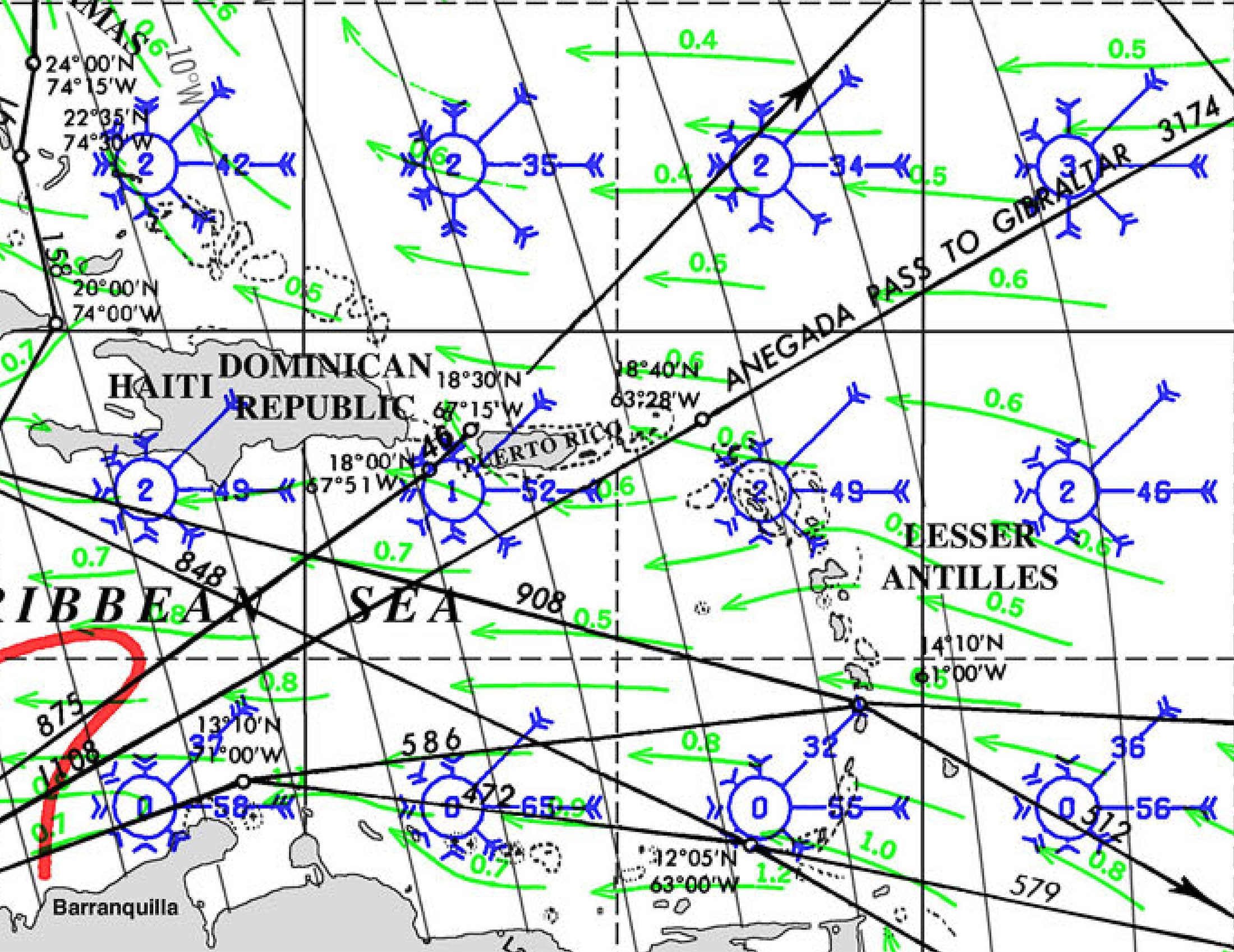
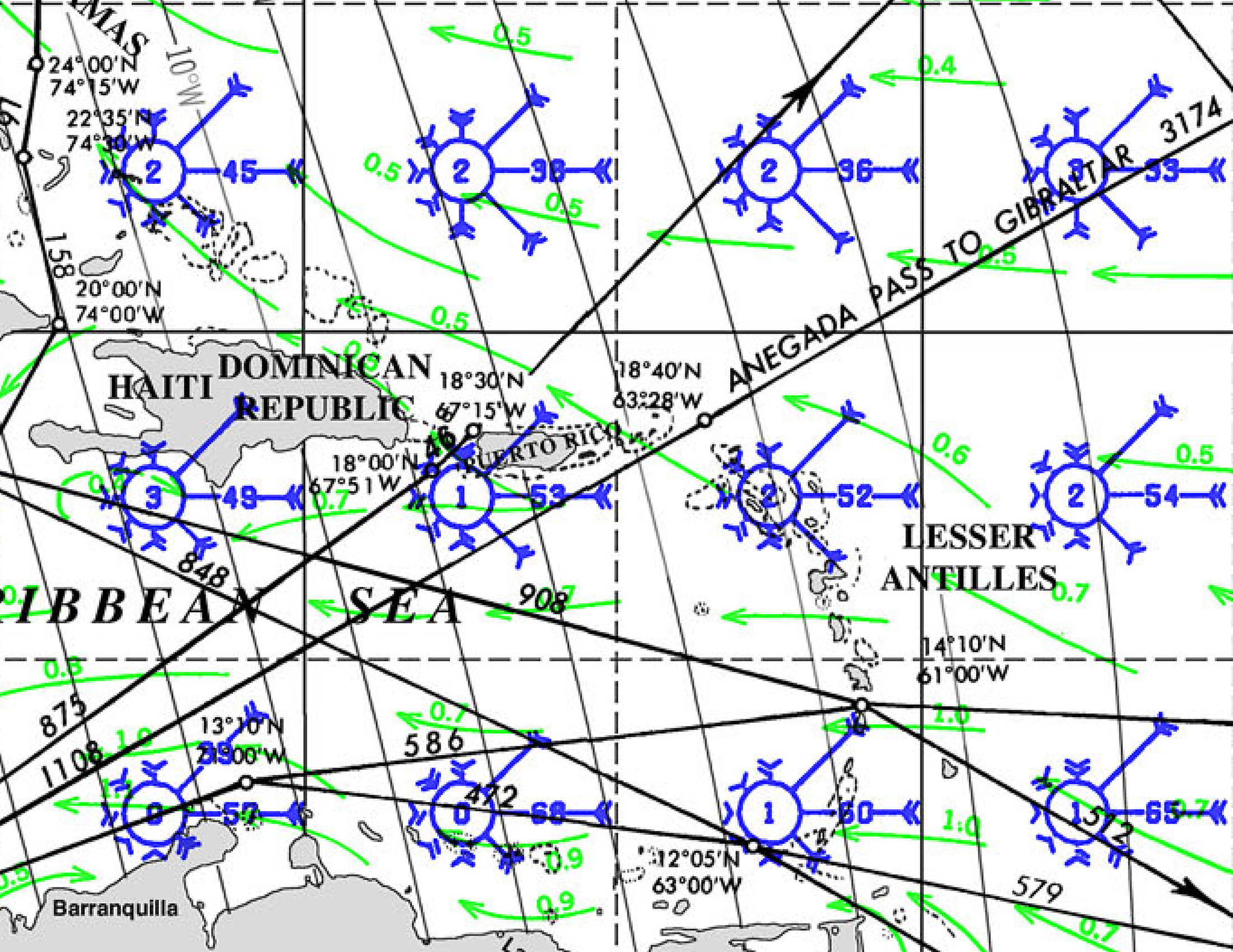
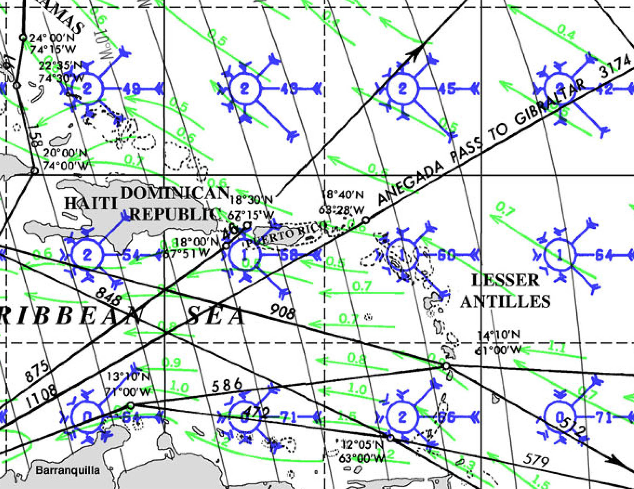
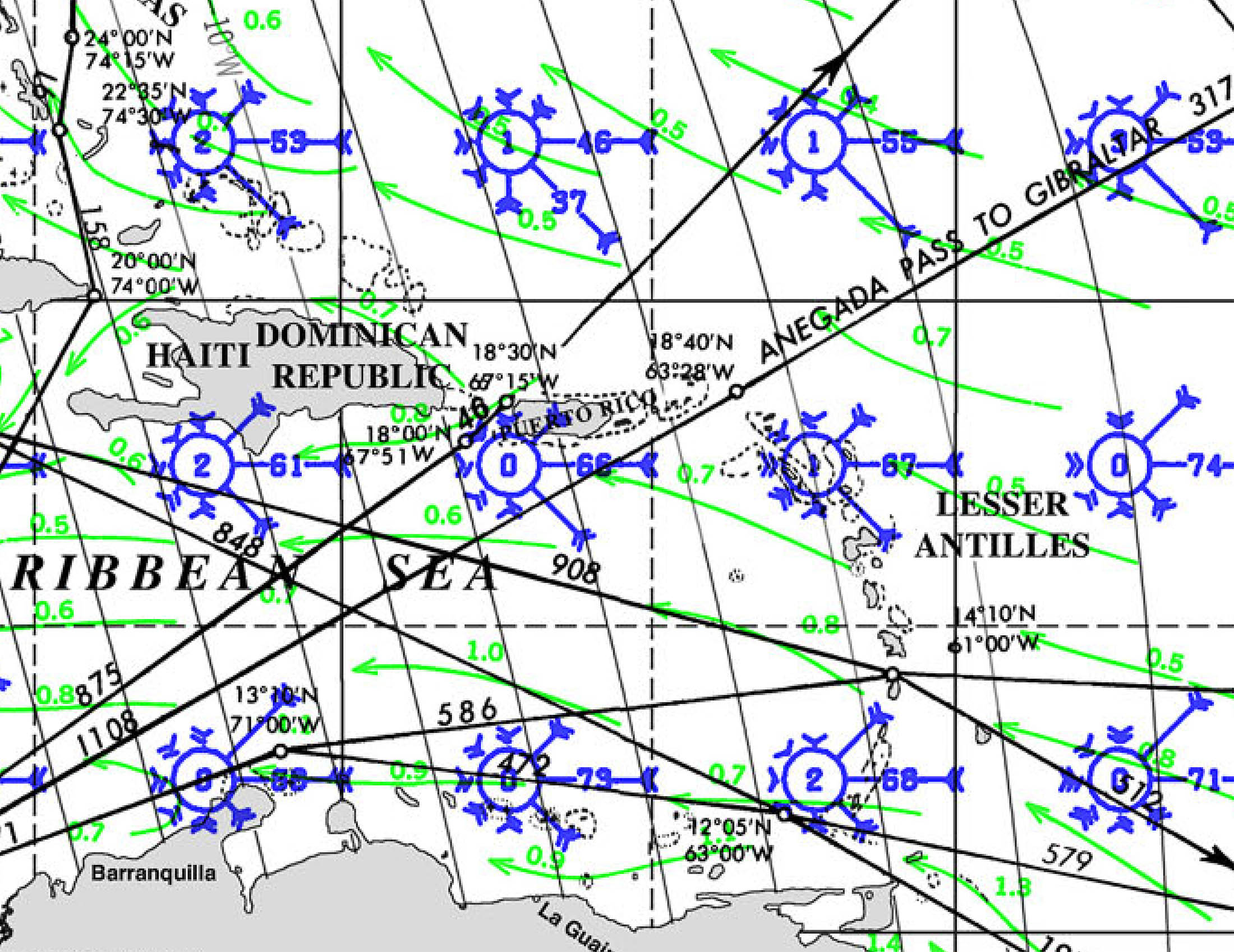
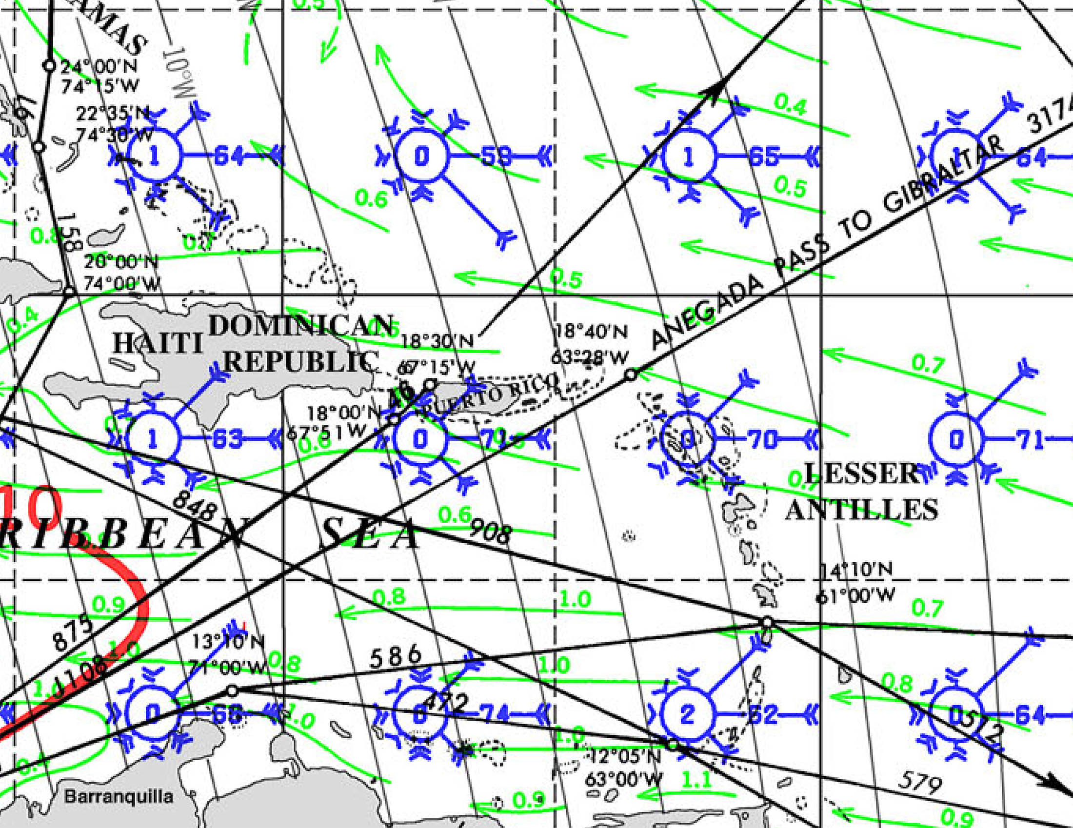
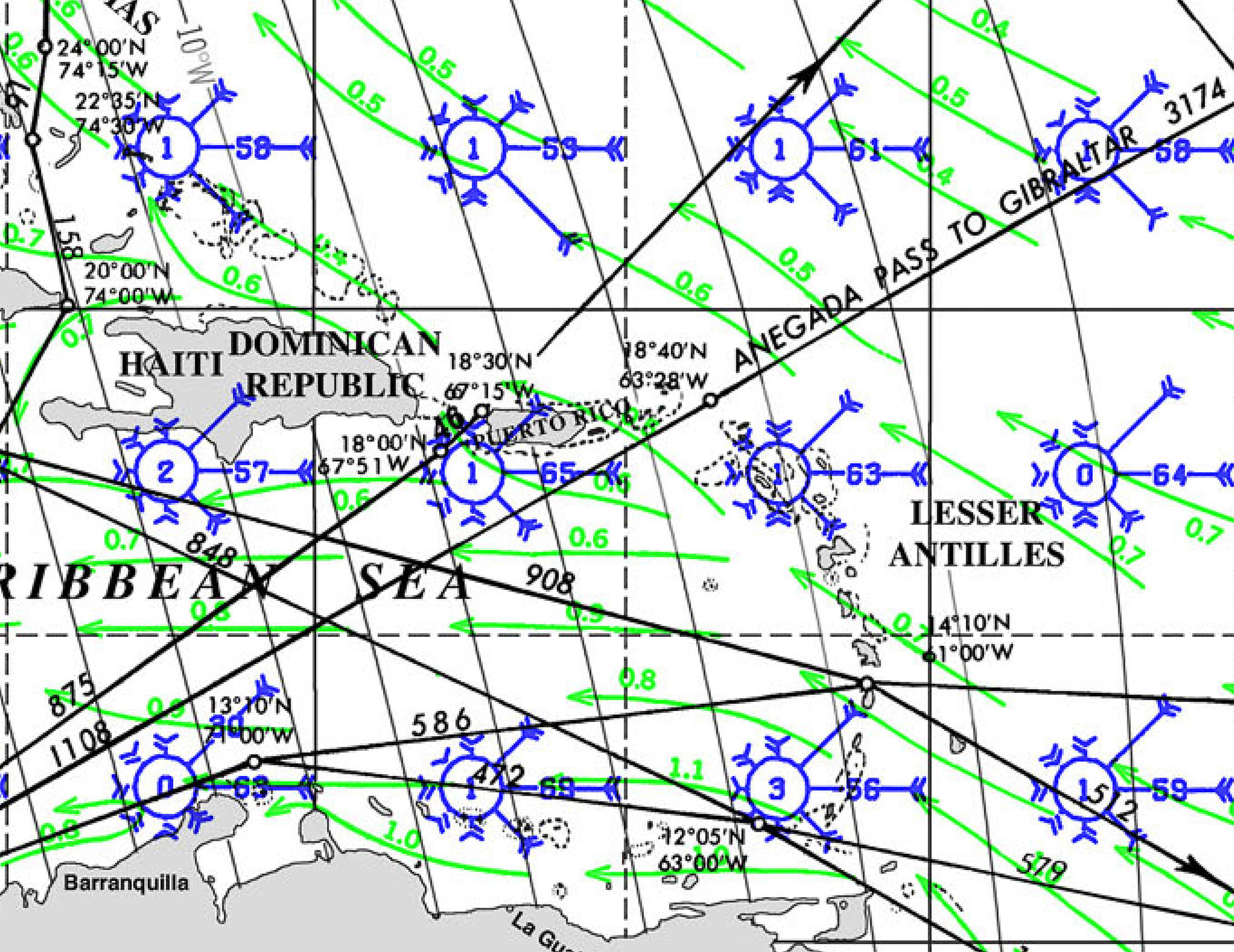
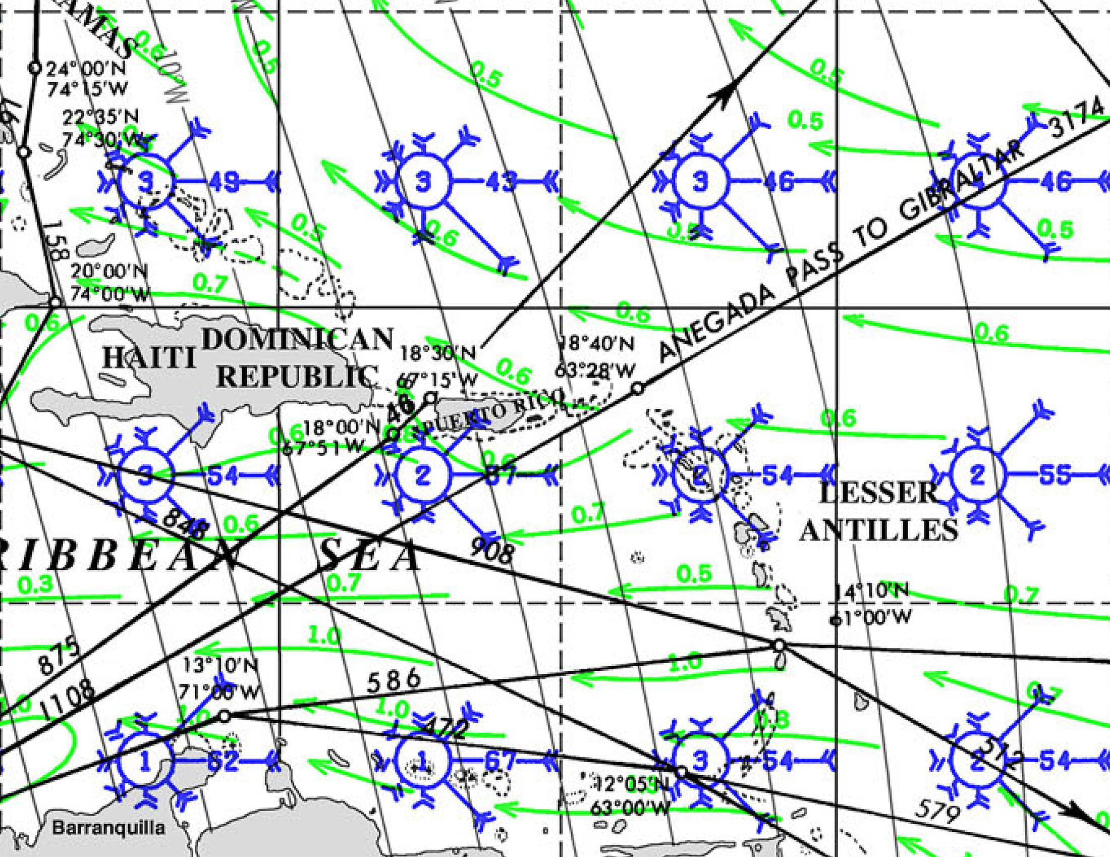
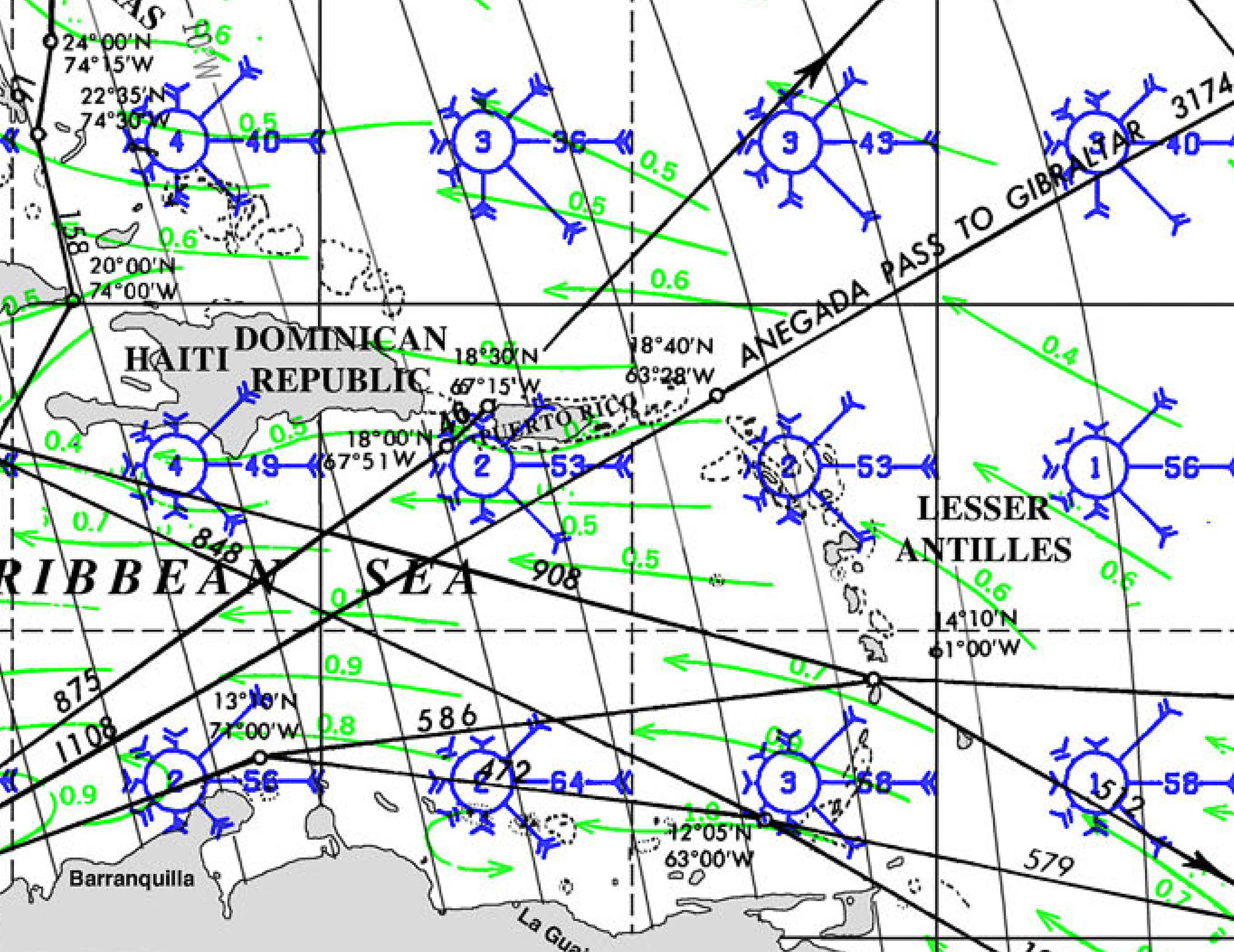
WINDS
CURRENTS
SWELL AND WAVES
AMAPALA, ISLA TIGRE 🇭🇳 HONDURAS
AMAPALA, ISLA TIGRE 🇭🇳 HONDURAS SIGN
SV DIVERGENT framed by the letter ‘P’ & anchored just off the town of Amapala
Isla
Tigre is In Bahia Fonseca. Bahia Fonseca is uniquely shared by
three countries: El Salvador (to the north and west), Honduras
(generally in the center), and Nicaragua (to the south and east).
Isla Tigre is part of Honduras. Visiting vessels are required to
check into the country at their first port of call.
Trip Report from SV DIVERGENT:
Amapala,
Isla Tigre, Honduras! We had a short but wonderful time there and would
definitely go back if we were headed south again.
There are no mooring balls or marina, but we anchored with good holding and plenty of room near the historic Amapala pier.
It
was easy to check in and out with the port captain and immigration
office, both located on the pier. We recall the cost being less than 20
USD.
The
port captain told us they only get a few cruisers each year. There is a
lot of panga traffic to and from the island. As a result, we received a
lot of viewing attention, and people were very friendly.
There is easy dinghy landing next to the pier at low tide.
All the streets we walked on or saw were cobblestone.
Local transportation is mainly via tuk-tuks. We also saw locals on motorbikes and quads.
There were several small tiendas suitable for provisioning.
There is an ATM on the main street near the pier.
Our
exploration and experience were only within the town of Amapala. We did
not get a chance to see the rest of the small island. Amapala is a
no-frills, authentic working village; there are not many tourist
amenities (restaurants, etc.). It was all about the experience for us –
some of the highlights were:
–
The main street connected to the pier has a colorful canopy of
umbrellas, which was fun to have as a backdrop for pictures. (The pier
itself is also quite colorful!)
–
Taking a tuk-tuk ride through town to several tiendas for provisioning.
Our driver was a friendly young man who was all smiles and eager to
suggest where we could shop.
-Seeing interesting historical architecture.
-Watching the locals at work, at play, or at their homes.
UMBRELLAS OVER COBBLESTONE
Umbrellas offer shade and bright colors along the cobblestone paths
TUK-TUK
Three wheeled Tuk-Tuks are the taxis in Amapala
GARY AND ENA
Ena and Gary enjoying Amapala on their way north along the coast.
SY TIAMAT 🇺🇸 Stephanie & Owen – Fountaine Pajot 44’
Gary

SOUTH PACIFIC TROPICAL CYCLONE SEASON OUTLOOK
SOUTH PACIFIC TROPICAL CYCLONE SEASON
NOVEMBER 1-APRIL 30
NEW OUTLOOK RELEASED
Tropical cyclones, like hurricanes, are known for their powerful winds, heavy rains, and potential to cause significant destruction. Tropical cyclones frequently affect the southern Pacific and can pose serious threats to both public health and infrastructure. All vessels are advised to have a plan of action for the cyclone season.

According to New Zealand's National Institute of Water and Atmospheric Research (NIWA) and Metservice, the South Pacific may see either fewer or a normal number of tropical cyclones this season. The cyclone season in the South Pacific starts November 1 and runs until the April 30, with the typical 'peak' of the season being January - March. The outlook that has recently been released, "Southwest Pacific Tropical Cyclone Outlook - October 2024" describes a slower start to the Cyclone season, potentially less cyclone risk overall in the eastern region while potentially elevated risk in the western region. According to the NIWA Outlook, "As of early October 2024, sea surface temperatures across the eastern and central equatorial Pacific Ocean are below average and close to La Niña thresholds." Forecasters are observing more La Niña-like characteristics that tend to reduce risk in the east and elevate risk in the west where warmer water may 'stack up' later in the season. As with many weather outlooks of late there continues to be caution that while there may be less risk in the frequency of tropical storms this season, there is still a risk that those that come may intensify more rapidly or simply be very intense.

For cruisers in French Polynesia South Pacific Posse member Scott on Tartaruga shares:
What is critical to following storms in FP is the location of the MJO. Madden Julien Oscillation. You can research that but when that is over French Poly that is when the highest probability of big storms occur. Per some local Tahiti sailors they almost never have any cyclonic storms outside of MJO events. This last season Fiji announced the MJO forecast and when it would be over FP and boom the storms came. Also note that Fiji is the official metrological organization for these storms. Another important data point is they name their storms very early, mean the wind scale starts at a much lower number....NOAA tracks (the MJO) closely as well. I would educate yourself on how to read the graph. It is a bit strange.
Fiji Meteorological Service Regional Specialized Meteorological Centre Nadi-Tropical Cyclone Centre also just released a forecast on the upcoming tropical Cyclone season. Their predictions are similar.

Stay alert on great weather sites including:
- https://www.met.gov.fj/index.php?page=tcoutlook
- https://niwa.co.nz/climate-and-weather/southwest-pacific-tropical-cyclone-outlook/southwest-pacific-tropical-cyclone-outlook-october-2024

EXPANDING POSSE PERKS: YACHT PORT CARTAGENA, SPAIN💰 Save real money at Marinas with discounts
ANNOUNCING: NEW MARINAS SIGNING ON WITH THE OCEAN POSSE
EXPANDING POSSE PERK:💰 Save real money at Marinas with discounts


SV QUESO GRANDE II and Captain Dietmar kicked off the first Ocean Posse event in Yacht Port Cartagena, Spain!
Dietmar says: Thank you Sherri for all the event support and promotion to the international cruisers who came! AND THANK YOU LANCE FOR SOME SUCCULENT RIBS !!!
Sherri from SV QUESO GRANDE II says: Great fun, great cruisers, and great grilled meat by my darling husband Lance.

Currently, the Ocean Posse has ????some number of marinas in ????some number of countries bla bla bla. This represents great savings bla bla bla

POSSE PERK: 🗺️3 DAYS OF LEARNING SEMINARS
POSSE PERK: 🗺️3 DAYS OF LEARNING SEMINARS
INCLUDED WITH OCEAN POSSE SIGN UPS
coming up in Safe Harbor, San Diego
October 23-25, 2024 @ Safe Harbor South Bay, San Diego
https://oceanposse.com/events/san-diego-seminar-series/
Sneak a Peak at the Seminars and Schedule...
WEDNESDAY OCTOBER 23rd, 2024 ● SEMINARS
$ 45 per person x day or FREE
FOR OCEAN ° PANAMA ° SOUTH PACIFIC POSSE PARTICIPANTS
09:00
Cruising down Pacific Mexico


10:00
Water Makers + Plumbing in Paradise


11:30
Diesel Engines & Generators and preventative Maintenance


12:30 LUNCH
Open CPN – installation and integration (PC + MAC )

14:00
Rigging 101 Standing and Running

15:30
Weather Weather Weather – planning – routing – underway


16:30
Crew the good the bad and the ugly

17:00
Destination Costa Rica and Nicaragua


THURSDAY OCTOBER 24th, 2024 ● SEMINARS
09:00
South Pacific – French Polynesia – Cook Islands – Tonga & Fiji


10:00
Safety Security and Emergencies outside the US and what to expect


11:00
Electrical Systems – Batteries, Chargers, Alternators, Solar Panels

12:30 LUNCH
Cruising in Panama + the Panama Canal


14:00
Where and how to repair boats outside the US

15:30
The tropics – Refrigeration, AC, Shading, Airflow + other ways to stay cool

17:00
Destination Colombia, Jamaica & Bay of Islands Honduras


FRIDAY OCTOBER 25th, 2024 ● SEMINARS + PARTY
09:00
Destination Belize & Rio Dulce Guatemala


10:00
Communications onboard, underway and on shore


11:30
The fundamentals of wires, connectors and fuses


12:30 LUNCH
Open CPN – Satellite Charts – Use Cases and Satellite Chart creation


14:00
Chart Accuracy, Navigation Trips and Tricks & Tracking

15:30
Provisioning, Propane and Fuel – where to replenish

17:00 – 21:00 PPPPARTY

AMAZING ANIMALS: HERMIT CRABS
AMAZING ANIMALS: HERMIT CRABS
By Josea Descheemaeker age 11

You probably see these creatures on every beach you go to and every time you go snorkeling. Hermit crabs can live in the water and on land due to the fact that they breath through gills.
Hermit crabs names are very deceiving for several reasons:
- As opposed to being hermits that prefer to always be alone, hermit crabs are vary social with other hermit crabs. Hermit crabs live and walk easily among their kind, over and under their kind, eating shell to shell in groups sometimes.
- They are more shy than hermit like. They are quick to hide in their shell when as little as a shadow passes over them.
- Hermit crabs are more closely related to spiders and scorpions than crabs,
 The reason people put Hermit in their name is because they carry their homes
everywhere they go . Hermit crabs are vary picky about what shells they live in and they switch shells when they grow too big for the one they are living in. Sadly, now some Hermit crabs use plastic bottle caps and other Plastic things as homes.

Many Hermit crabs love to decorate their shells. Hermit crabs can lift things 10 times their weight . Despite a hermit crab's size they Typically live up to 30 years in the wild and some live up to 60 years. There are about 500 Species of hermit crabs all over the world And with a lot of colors blues reds whites And oranges And sometimes all of those colors on one hermit crab. Some colors can be very bright.
Hermit crabs have many predators too such as big crabs, birds, and fish that keep the hermit crab population down. Hermit cards eat pretty much anything they can fined and from my experience they love coconut.

Believe it or not hermit crabs and coconut crabs are closely related. While hermit crabs live in shells their entire life, coconut crabs only live in shells when they are young.
My Experience
Hermit crabs are very shy animals. When you get to close to them they retreat into their shells. When I put a hermit crab on my hand most will be very eager to run off and get away from me. It is a rare hermit crabs, typically the bigger ones, that will try to pinch me. Do not be deceived by their small size, they have very large claws and it hurts a lot when they pinch you. If you are hiking off the beach and when you’re still close to the beach, you can sometimes find hermit crabs clinging to the tree. If you’re taking a shell from the beach look very closely and make sure there’s not a hermit crab in it. At 1st glance some shells look like they don’t have any hermit crabs in them but the small hermit crab sometimes get in shells way too big for them and it’s very hard to see them so look very closely. This has happened to me sometimes and I have accidentally brought a hermit crab in their shells back to the boat. If there's a shy hermit crab that you want out of the shell you can cup it in your hands and breathe onto them. This typically coaxes them out because of the warmth of your breath but there are some that are just too scared and they won't come out.

SY WHIRLWIND 🇺🇸 Maurisa, Mike, Russell & Josea – Alajuela 48’


MUST SEE: 🇵🇫 Taputapuātea on Ra’iātea Island, French Polynesia
MUST SEE: 🇵🇫 Taputapuātea on Ra’iātea Island, French Polynesia
in 2017 UNESCO named Taputapuātea on Ra’iātea Island, French Polynesia a world heritage site for its outstanding universal value, exceptional testimony to 1,000 years of pre-colonial mā'ohi civilization, and central location in the 'Polynesian Triangle'. The 'points' on the Polynesian triangle are New Zealand, Hawaii, and Rapa Nui. Taputapuātea is in the very center of this triangle of oceanic islands. Both the cultural landscape and seascape on Ra’iātea make this a unique and remarkable place one must see. Taputapuātea is an area that goes from the mountains through forested valleys spanning across a portion of lagoon and coral reef and a strip of open ocean. In the center is the Marae of Taputapuātea.

The Marae of Taputapuātea is considered to be the most sacred pre-colonial Polynesian archeological sites in French Polynesia. UNESCO describes this site as:
"dedicated to the god ‘Oro and the place where the world of the living (Te Ao) intersects the world of the ancestors and gods (Te Po). It also expresses political power and relationships. The rise in the importance of Taputapuātea among the marae on Raiatea and in the wider region is linked to the line of Tamatoa ari’i (chiefs) and the expansion of their power. Taputapuātea was the centre of a political alliance that brought together two widespread regions encompassing most of Polynesia. The alliance was maintained by regular gatherings of chiefs, warriors and priests who came from the other islands to meet at Taputapuātea. The building of outrigger canoes and ocean navigation were key skills in maintaining this network.
A traditional landscape surrounds both sides of the Taputapuātea marae complex. The marae complex looks out to Te Ava Mo'a, a sacred pass in the reef that bounds the lagoon. Atāra motu is an islet in the reef and a habitat for seabirds. Ocean-going arrivals waited here before being led through the sacred pass and formally welcomed at Taputapuātea. On the landward side, ’Ōpo’a and Hotopu’u are forested valleys ringed by ridges and the sacred mountain of Tea’etapu. The upland portions of the valleys feature older marae, such as marae Vaeāra’i and marae Taumariari, agricultural terraces, archaeological traces of habitations and named features related to traditions of gods and ancestors. Vegetation in the valleys is a mix of species, some endemic to Raiatea, some common to other Polynesian islands and some imported food species brought by ancient Polynesians for cultivation. Together, the attributes of the property form an outstanding relict and associative cultural landscape and seascape."
Throughout Polynesia the Marae are communal or sacred sites in village life. In order to build a marae in another location, it is said that one must start with a stone from Taputapuātea. The marae are places with different functions. They are places where the world of the living intersected with the world of village ancestors and Polynesian gods. They are places where people gather for ceremony, dance, connecting with the past and with community.

This video is a product of the cumulative effort of cultural and historical groups presenting the significance of Taputapuātea in the past, the present, and for the future.
https://youtu.be/wXbJXHR8-3g?t=391


FIJIAN CULTURE AND THE SEVUSEVU PROCESS
FIJI: THE SEVUSEVU PROCESS
In traditional villages in Fiji Sevusevu is and has been the central component of all life-cycle rituals, social gatherings, healing ceremonies and community meetings. Significant and ancient in Fiji, the “sevusevu” also marks the time and place for visitors to seek acceptance into a Fijian village.

Every Sevusevu is not as formal as pictured above however there is a distinct and courteous process visitors must follow. Further, understanding the significance of Sevusevu, respecting, and adhering to the tradition of this process helps to keep this aspect of Fijian Culture strong.
Longtime Ocean Posse member Chris on SV SEAGLUB has been living in Fiji for several years. He shares the following about his experience with the Sevesevu:
In Fiji, when visiting smaller settlements, a visitor must seek out the village chief and present him with a small token or gift as a sign of respect and to ask permission to visit. This not only gives visitors permission to interact with the villagers but also to stay in the town and to visit any local scenery (such as beaches, waterfalls etc). Not doing so shows disrespect for their culture, but is also the equivalent of trespassing – for example pitching a tent in someone's backyard without permission.
‘Sevusevu’ is the name given to the actual gift or token that visitors present the chief with, most commonly a half-kilo bumdle of waka (kava root). When arriving in the village, visitors should ask for the Turaga ni Koro (pronounced as too-ranga nee koro) or the village headman, as they usually have good English skills and will help with the translations. The headman will take visitors to the chief’s house for introduction. Remember no hats are to be worn once in the village and you should take your shoes off at the door before entering houses. Sitting cross legged on the floor, the kava root is then presented to the chief.
To ensure you are respectful of this important tradition, there are a few points of etiquette to follow. Firstly, everyone at the ceremony should dress in a sulu, which is a Fijian skirt regarded as their national dress. Women should also cover their shoulders. Men should sit cross-legged, ensuring that their sulu covers their knees, and women should sit with knees and feet together. Do not take photographs or videos throughout the ceremony, until the Turaga ni Koro lets you know that it’s okay to do so. Silence during the ceremony itself is crucial.
The ceremony itself is poignant. Afterwards you'll be welcomed as nothing less than family.
SV SEAGLUB 🇺🇸 Chris -Hylas 46'


LOGISTICAL PREPARATIONS
LOGISTICAL PREPARATIONS FOR LEAVING HOME WATERS AND ENTERING NEW COUNTRIES

Leaving ones home waters and entering a new country is certainly a big change and there are many essential details not to forget. Checklists are handy tools for preparing for Entry and Exit Requirements. Beyond the obvious boat essentials like checking your systems, having safety equipment onboard, topping your fluids, and changing your zincs, please see the checklist below for details not to be forgotten when setting out on a long distance voyage with the Ocean Posse.
- If an EPIRB is onboard a US flagged vessel, register it with the NOAA. Before leaving confirm that all information is current. This includes vessel name, your primary phone number, emergency contact name/s and address/es: https://beaconregistration.noaa.gov/RGDB/registrationRequirements
- A Ship Stations License is required by the FCC for travelling in international territories: https://www.fcc.gov/wireless/bureau-divisions/mobility-division/maritime-mobile/ship-radio-stations/ship-radio-stations
- Make sure the MMSI number of your vessel is registered in your name: https://www.fcc.gov/wireless/bureau-divisions/mobility-division/maritime-mobile/ship-radio-stations/maritime-mobile
- Have your boat documentation or registration up to date and in order. NOTE: most countries (and the Panama Canal Authorities) are requiring international navigation documentation indicating nationality and ownership over state registration. Check with your destination country.
- If the boat is documented or registered in the name of someone not present or the name of a business or organization: a letter notarized by the documented vessel owner authorizing the captain and crew to be operating the vessel is required to enter other countries (and transit the Panama Canal). It is imperative to have both the original and copies of all notarized documents.
- Depending on the country you enter you will buy a Temporary Import Permit which allows the vessel to enter the country. This is an important document to keep with the vessel the entire time in the country of entry. This document is also required upon exiting many countries.
- Current passport for everyone onboard ideally good for the duration of your stay abroad.
- Many countries require a Crew List upon entry which states everyone onboard, their Date of Birth, their rank on the vessel and their passport number.
- If navigating into Mexico, Mexican Liability Insurance is required to Navigate in Mexican waters.
- If navigating in Mexico, the captain is required to show a boaters education card, ASA certification, or a captains license upon exiting the country.
- Outside of the United States, when exiting one country and entering another you will need an authorized document of exit (called a zarpe throughout Central America) from one country in order to enter the next country.
- Wherever you go along the route, be prepared for entry and exit requirements and seasonal changes.
It is not entirely uncommon for requirements to vary port to port. The best practice is to be prepared with everything and not be asked for them than to be asked for something you do not have.


FIJI REGATTA WEEK 2024
UPCOMING EVENT : FIJI REGATTA WEEK
11-15 September, 2024
in beautiful Musket Cove

Registration for the 2024 40th Anniversary Regatta is now open. Please book early!
This link will take you to the Regatta Registration form.
Please note this form is for Regatta Registrations only. For all Marina Berth and Mooring bookings, please email Patrick directly at: mcyc@musketcovefiji.com. Please book early as there are limited Marina Berths available.
https://pacificposse.com/musket-cove-marina
MUSKET COVE MARINA 
SPONSORS THE PANAMA POSSE

We welcome any of the South Pacific Posse to Musket Cove at any time.
We’re pleased to offer a Free Berthing Day for 5 Paid Days to all of your Posse Members.

Wayne Deed
Director of Sales & Marketing
Musket Cove Island Resort & Marina
Malolo Lailai Island
Fiji Islands
m| +64 21 824266
P | +679 666 2215

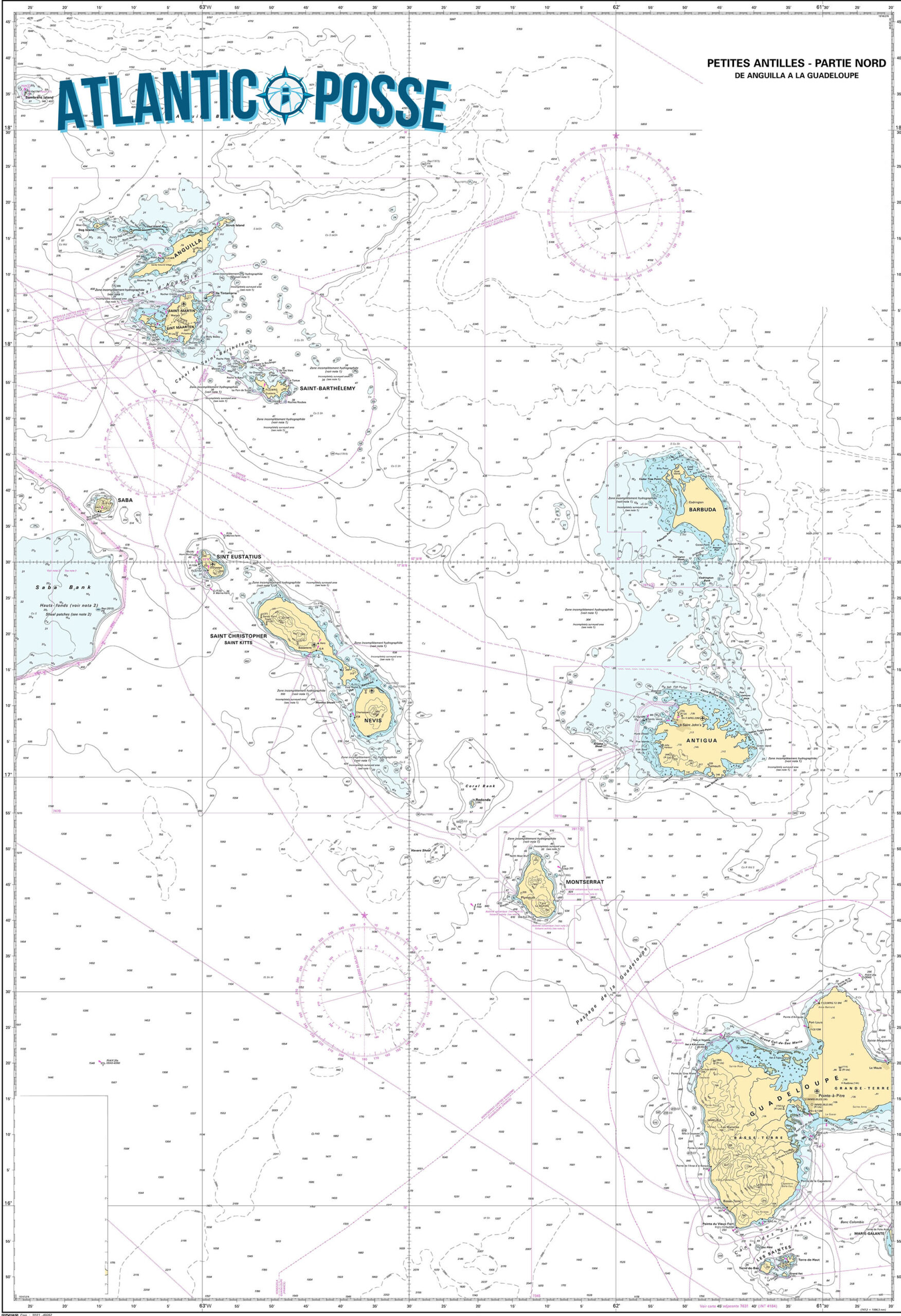
SABA 🇳🇱 CRUISING THE CARIBBEAN WITH THE OCEAN POSSE
SABA 🇳🇱
 Tucked away in the northeastern Caribbean, Saba Island is one of the most remarkable yet lesser-known destinations in this region. As a captain, steering towards this volcanic peak rising from the ocean is an experience that evokes both anticipation and admiration. Saba, often referred to as the “Unspoiled Queen,” is part of the Netherlands Antilles and offers a pristine and authentic Caribbean experience that’s becoming increasingly rare in the region.
Approaching Saba: A Test of Skill
Navigating to Saba requires precision and respect for the island’s unique topography and weather patterns. The island, with its steep cliffs and lack of natural harbors, is not for the faint-hearted or the inexperienced mariner. Approaching from the southeast, you’ll be greeted by the towering Mount Scenery, a dormant volcano that is the highest point in the Netherlands. The island’s coastline is rugged, with waves crashing against sharp rocks and the occasional black sand beach peeking through the cliffs.
Given its small size—just five square miles—Saba is surrounded by deep waters. This means that the approach to Saba requires careful attention to charts, weather conditions, and tidal movements. The island lacks extensive coral reefs or sandbanks that many Caribbean sailors might be used to, which simplifies navigation but requires a cautious approach due to the steep underwater drop-offs close to shore.
Mooring at Saba
The island’s only official point of entry for vessels is Fort Bay, located on the southwestern coast. Fort Bay is a small and practical harbor, home to a few commercial docks and a handful of mooring buoys maintained by the local government. Because of the island’s rugged coastline, anchoring is not allowed, and visitors must use one of these buoys. It’s advisable to contact the harbor in advance to ensure availability, especially during peak season.
Mooring here is a skillful task, given the potential for strong currents and winds funneled between the cliffs. The bay is protected, but not immune to the surge from the open sea, making it imperative to check the weather forecast before arrival. Once securely moored, the first breath you take is a combination of relief and awe—the beauty of Saba lies in its untouched wilderness and the sense of remoteness that permeates the air.
Onshore Experience: A Journey Back in Time
Stepping ashore in Saba feels like entering a different era. The island’s four quaint villages—The Bottom, Windwardside, St. Johns, and Zion’s Hill—are connected by narrow, winding roads that cling to the steep slopes. These roads were constructed by hand by the island’s residents, a testament to their resilience and dedication. For captains and their crews, the exploration of these villages is a must.
The Bottom, the island’s capital, is the most accessible from Fort Bay. It’s a small, picturesque town with red-roofed houses, lush gardens, and friendly locals who greet visitors with a warmth that’s becoming rare in more commercialized parts of the Caribbean. Despite its name, The Bottom sits at an elevation of about 800 feet above sea level, offering panoramic views of the surrounding ocean.
Windwardside, located further up the slopes, is another highlight. This village is the heart of Saba’s tourism, where you’ll find small hotels, charming guesthouses, and a handful of restaurants offering local cuisine. The Saba lacework, a traditional craft passed down through generations, is a unique souvenir that visitors can take home as a reminder of this tranquil island.
Hiking and Exploration: The Crown Jewel of Saba
For those who enjoy the great outdoors, Saba is a paradise. The island’s rugged terrain offers some of the best hiking in the Caribbean. The crown jewel of Saba’s hiking trails is the climb to the summit of Mount Scenery. At 2,910 feet, it’s the highest point in the Dutch Kingdom, and the trail to the top is a challenge that rewards you with breathtaking views. The trail is well-marked but steep, with 1,064 steps leading through dense rainforest to the summit. On a clear day, you can see the neighboring islands of St. Eustatius, St. Kitts, and even St. Barths.
For captains and crew members looking to stretch their legs after days at sea, this hike is a perfect way to immerse yourself in Saba’s natural beauty. The island’s flora and fauna are remarkable, with over 200 species of plants and a rich diversity of birdlife. The trail to Mount Scenery is often shrouded in mist, adding a mystical quality to the journey.
Diving in Saba: A Subaqueous Adventure
Beyond the surface, Saba is renowned for its exceptional diving opportunities. The Saba Marine Park, established in 1987, surrounds the island and offers some of the most pristine dive sites in the Caribbean. The island’s volcanic origins have created a unique underwater landscape of pinnacles, coral gardens, and steep drop-offs.
One of the most famous dive sites is the Pinnacles, a series of underwater mountains that rise dramatically from the ocean floor. These pinnacles are teeming with marine life, from colorful coral formations to large schools of tropical fish, sharks, and rays. For experienced divers, the thrill of exploring these deep-water sites is unparalleled.
As a captain, facilitating a diving excursion for your crew or guests is an opportunity to showcase the hidden wonders of Saba. Local dive shops, such as Sea Saba and Saba Divers, offer guided dives and equipment rentals. It’s important to coordinate with these operators in advance, as diving in Saba requires adherence to strict environmental guidelines to protect the fragile marine ecosystem.
The Allure of Isolation
One of the most striking aspects of Saba is its sense of isolation. Unlike other Caribbean islands, where tourism is a dominant force, Saba has remained largely untouched by mass tourism. There are no large resorts, no bustling beaches, and no shopping malls. Instead, you’ll find an island that moves at its own pace, where the natural environment and the local culture are deeply intertwined.
For captains and sailors, this sense of isolation is both a challenge and a reward. Saba is a place where you can disconnect from the outside world, where the only sounds are the wind in the trees and the waves against the rocks. It’s a place that invites introspection and a deeper connection with the sea.
Practical Considerations for Visiting Captains
While Saba’s charm lies in its remoteness, this also means that certain practical considerations must be taken into account. Provisioning on the island is limited, so it’s essential to stock up on supplies before arrival. Fuel is available at Fort Bay, but it’s recommended to refuel at a larger port before heading to Saba.
Communication can also be a challenge. While the island has decent cellular coverage, internet access can be slow and unreliable. For captains who rely on digital navigation tools and weather updates, it’s wise to download necessary data before approaching the island.
Lastly, it’s important to respect the local regulations, particularly those related to environmental protection. Saba’s government and residents are committed to preserving the island’s natural beauty, and visiting sailors are expected to do their part. This includes proper waste disposal, adherence to mooring guidelines, and respecting the marine park’s no-anchor zones.
Departure: Leaving the Unspoiled Queen
Departing from Saba is a bittersweet experience. As you release the mooring and navigate away from the island’s dramatic coastline, there’s a sense of having discovered a place that few others have. Saba’s rugged beauty, its welcoming communities, and its unspoiled nature leave a lasting impression on those who venture to its shores.
For a captain, Saba is more than just a stopover; it’s a destination that challenges your skills, enriches your journey, and reminds you of the simple, untamed beauty that the Caribbean can still offer. As the island fades into the horizon, there’s a quiet understanding that Saba will remain one of those rare places—a true gem of the sea, cherished by those who have had the privilege to experience it.
In the end, Saba is a testament to the enduring allure of the sea and the islands that rise from it. It’s a place where the spirit of exploration lives on, where the call of the ocean meets the whispers of the wind, and where a captain can find not just a destination, but a profound connection to the world and its wonders.
MARINAS
Saba is a unique destination in the Caribbean due to its rugged terrain and lack of natural harbors, which limits the availability of traditional marinas. The island has only one official point of entry and limited facilities for yachts and boats:
1. Fort Bay Harbor
- Location: 17°37’36.0″N 63°14’13.0″W
- Description: Fort Bay Harbor is the only port and official entry point for vessels on Saba. It is located on the southwestern side of the island. The harbor primarily serves commercial and government vessels but provides limited services for visiting yachts. The harbor is small and can accommodate only a few vessels at a time. Mooring buoys are available in the harbor for visiting boats, as anchoring is not allowed due to the steep underwater drop-offs and to protect the marine environment.
- Facilities: The facilities are minimal, with basic services available, including fuel, water, and customs/immigration clearance. There is a small pier for loading and unloading supplies. However, there are no extensive marina facilities such as repair services or chandlery.
- Contact Information: It’s recommended to contact the harbor authorities in advance to arrange for mooring and entry procedures. Saba’s Marine Park Office also assists with mooring information and regulations.
Key Considerations:
- Mooring: Due to the limited space and facilities, it’s essential to secure a mooring buoy ahead of time, especially during peak seasons. Anchoring is prohibited around the island to protect the coral reefs and marine environment.
- Provisioning: Saba has limited resources, so it’s advisable to provision before arrival. There are a few small grocery stores on the island, but options are limited.
- Fuel: Available at Fort Bay Harbor, but supply can be limited, so plan accordingly.
- Customs and Immigration: All vessels must check in at Fort Bay Harbor, where customs and immigration procedures can be completed.
WEATHER
MAIN LOCAL WEATHER WEBSITE SABA 🇳🇱
SEVERE WEATHER SABA 🇳🇱
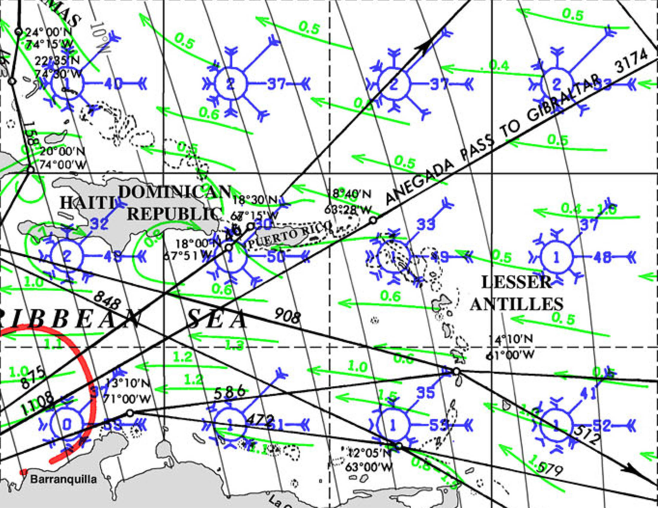
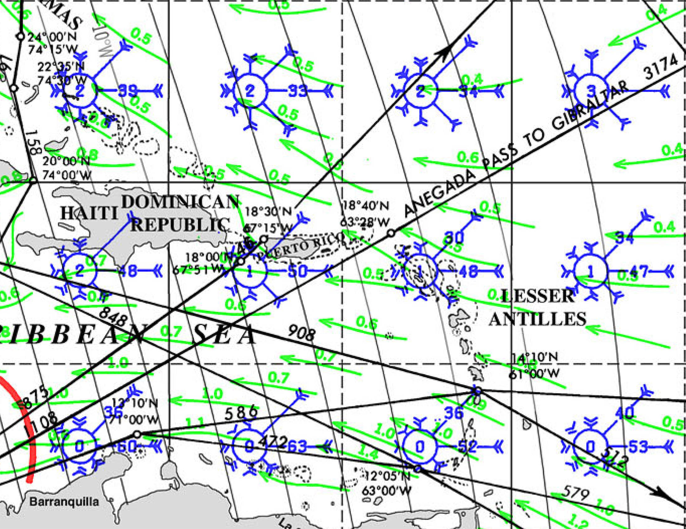
PILOT CHARTS
PORTS OF ENTRY
Saba is a unique destination in the Caribbean due to its rugged terrain and lack of natural harbors, which limits the availability of traditional marinas. The island has only one official point of entry and limited facilities for yachts and boats:
1. Fort Bay Harbor
- Location: 17°37’36.0″N 63°14’13.0″W
- Description: Fort Bay Harbor is the only port and official entry point for vessels on Saba. It is located on the southwestern side of the island. The harbor primarily serves commercial and government vessels but provides limited services for visiting yachts. The harbor is small and can accommodate only a few vessels at a time. Mooring buoys are available in the harbor for visiting boats, as anchoring is not allowed due to the steep underwater drop-offs and to protect the marine environment.
- Facilities: The facilities are minimal, with basic services available, including fuel, water, and customs/immigration clearance. There is a small pier for loading and unloading supplies. However, there are no extensive marina facilities such as repair services or chandlery.
- Contact Information: It’s recommended to contact the harbor authorities in advance to arrange for mooring and entry procedures. Saba’s Marine Park Office also assists with mooring information and regulations.
Key Considerations:
- Mooring: Due to the limited space and facilities, it’s essential to secure a mooring buoy ahead of time, especially during peak seasons. Anchoring is prohibited around the island to protect the coral reefs and marine environment.
- Provisioning: Saba has limited resources, so it’s advisable to provision before arrival. There are a few small grocery stores on the island, but options are limited.
- Fuel: Available at Fort Bay Harbor, but supply can be limited, so plan accordingly.
- Customs and Immigration: All vessels must check in at Fort Bay Harbor, where customs and immigration procedures can be completed.
MUST SEE
1. Mount Scenery
- Location: 17°37’31.2″N 63°14’50.4″W
- Description: Mount Scenery, standing at 2,910 feet, is the highest point in the Netherlands and the Caribbean. This dormant volcano offers one of the most rewarding hikes in the region. The trail leading to the summit starts in Windwardside and takes you through lush rainforests filled with exotic flora and fauna. As you ascend the 1,064 steps, you’ll be enveloped in a mystical cloud forest. The summit, often shrouded in mist, offers breathtaking views on clear days, with sights extending to neighboring islands like St. Eustatius and St. Kitts. This hike is a must for any nature lover or adventurer visiting Saba.
- Best Time to Visit: The best time to hike Mount Scenery is during the dry season, from December to April, when the trail is less slippery, and the weather is cooler.
2. Saba Marine Park
- Location: 17°37’24.0″N 63°14’06.0″W
- Description: Established in 1987, the Saba Marine Park surrounds the entire island and is a sanctuary for marine life. The park is renowned for its pristine dive sites, including the famous Pinnacles, underwater mountains that rise from the deep ocean floor. The park’s clear waters, healthy coral reefs, and abundant marine species make it a diver’s paradise. Whether you’re diving or snorkeling, you’ll encounter vibrant coral gardens, tropical fish, sea turtles, and even sharks. The park is meticulously maintained, with strict regulations to preserve its beauty for future generations.
- Best Time to Visit: The best time to visit Saba Marine Park is from December to May, when sea conditions are calm, and visibility is at its best.
3. The Bottom
- Location: 17°37’45.6″N 63°14’49.2″W
- Description: The Bottom is the quaint capital of Saba, nestled in a valley surrounded by steep hills. This village is the administrative heart of the island and home to Saba University School of Medicine. Its charming red-roofed houses, manicured gardens, and friendly locals give The Bottom a warm, welcoming atmosphere. Key sites include the historic Dutch Reformed Church, built in 1919, and the Saba Archaeological Center, which offers insights into the island’s rich history. The Bottom is a perfect place to start your exploration of Saba and to experience the island’s unique culture and community.
- Best Time to Visit: The Bottom can be visited year-round, but the dry season from December to April offers more comfortable weather for exploring the village.
4. Windwardside
- Location: 17°37’54.0″N 63°13’59.4″W
- Description: Windwardside is one of the most picturesque villages on Saba, perched high on the slopes of Mount Scenery. This vibrant village is the heart of Saba’s tourism, with charming guesthouses, restaurants, and shops selling local crafts such as Saba lace. Windwardside offers stunning views of the surrounding hills and ocean, and it’s the starting point for many of the island’s hiking trails. Notable sites include the Saba Museum, which showcases the island’s cultural heritage, and the trailhead for the Mount Scenery hike. Windwardside is the perfect base for exploring the natural and cultural treasures of Saba.
- Best Time to Visit: Visit Windwardside from December to April, when the weather is cooler, and the skies are clear, offering the best views.
5. Tide Pools at Flat Point
- Location: 17°38’06.0″N 63°14’10.8″W
- Description: The Tide Pools at Flat Point offer a unique opportunity to explore Saba’s volcanic coastline. These natural pools are formed by the ocean’s waves crashing into the rocky shore, creating isolated pools filled with marine life. Exploring the tide pools is a fascinating experience, especially during low tide when the pools are more accessible. The pools are teeming with small fish, crabs, and other sea creatures, making it a great spot for nature enthusiasts and photographers. The dramatic backdrop of the cliffs and the sound of the ocean create a serene, otherworldly atmosphere.
- Best Time to Visit: The best time to visit the tide pools is during low tide and calm seas, which are most common from December to April.
6. Ladder Bay
- Location: 17°38’15.0″N 63°14’52.8″W
- Description: Ladder Bay is a historic site on Saba’s western coast, where goods and people were once transported to and from the island before Fort Bay Harbor was constructed. The “Ladder” refers to the steep set of stone steps carved into the cliff, leading from the bay to the village above. Although the climb is challenging, the views from the top are spectacular. The bay itself is a popular spot for snorkeling and diving, offering clear waters and an abundance of marine life. Ladder Bay is a place where history and nature converge, providing a glimpse into Saba’s past and its natural beauty.
- Best Time to Visit: The best time to visit Ladder Bay is from December to April, when the seas are calm, making it easier to explore the bay’s underwater treasures.
7. Troy Hill
- Location: 17°38’30.0″N 63°13’54.0″W
- Description: Troy Hill is a lesser-known but equally captivating spot on Saba. Located near the village of Hell’s Gate, this hill offers panoramic views of the island’s northern coastline and the neighboring island of St. Eustatius. The hike to Troy Hill is moderate, taking you through Saba’s lush, unspoiled landscapes. Along the way, you’ll encounter diverse plant life and may spot some of the island’s resident bird species. At the summit, you’re rewarded with a sense of tranquility and awe as you take in the sweeping views of the Caribbean Sea and the surrounding islands.
- Best Time to Visit: The best time to hike Troy Hill is during the dry season, from December to April, when the trail is in its best condition.
SERVICES & REPAIRS
given its small size and rugged terrain, has limited marine services compared to larger Caribbean islands. However, the island does offer essential services for visiting yachts and boats, particularly in and around Fort Bay Harbor, the main point of entry for vessels. Here’s an overview of the marine services available on Saba:
1. Mooring Buoys
- Location: Fort Bay Harbor, 17°37’36.0″N 63°14’13.0″W
- Description: Due to the steep underwater drop-offs around Saba, anchoring is prohibited. Instead, the island provides several mooring buoys in Fort Bay Harbor for visiting yachts. These moorings are well-maintained and suitable for vessels of varying sizes. It’s advisable to contact the harbor in advance to ensure availability, especially during peak season.
2. Fuel and Water
- Location: Fort Bay Harbor
- Description: Fuel is available at Fort Bay Harbor, though the supply can sometimes be limited, so it’s recommended to refuel before arriving in Saba. Water is also available at the harbor, but visitors should be mindful that water is a precious resource on the island, especially during the dry season.
3. Customs and Immigration Services
- Location: Fort Bay Harbor
- Description: All vessels must check in at Fort Bay Harbor, where customs and immigration services are available. The office is located near the dock, and the process is straightforward, with officials typically available during standard business hours. It’s recommended to have all necessary documentation ready, including passports, vessel registration, and crew lists.
4. Marine Park Regulations and Services
- Location: Saba Marine Park Office, Fort Bay Harbor
- Description: The Saba Marine Park office, located near Fort Bay, provides information and services related to the marine environment. This includes issuing permits for diving and providing guidelines on the use of mooring buoys. The park is highly protected, so all activities must comply with regulations designed to preserve the marine ecosystem.
5. Provisions and Supplies
- Location: Various small shops in The Bottom and Windwardside
- Description: Saba has a few small grocery stores in The Bottom and Windwardside where basic provisions can be purchased. However, given the limited supply, it’s advisable to stock up on essentials before arriving on the island. Specialty items and extensive provisions may not be available.
6. Waste Disposal
- Location: Fort Bay Harbor
- Description: Waste disposal services are available at Fort Bay Harbor, but visitors are expected to follow strict guidelines to protect the island’s environment. Recycling and proper waste management are emphasized, and all visitors are encouraged to minimize their environmental impact.
7. Diving Services
- Location: Windwardside
- Description: Saba is renowned for its diving, and there are a few dive shops, such as Sea Saba and Saba Divers, that offer guided dives, equipment rental, and dive certification courses. While these services are not directly marine services, they are essential for visitors interested in exploring Saba’s underwater attractions.
8. Emergency and Rescue Services
- Location: Fort Bay Harbor
- Description: Saba has a basic emergency response system in place, with services coordinated through the harbor and local authorities. While the island does not have extensive marine rescue facilities, it is part of the regional maritime network, which can be called upon in case of emergency.
EMERGENCIES AND SAR INFO
Saba officials listening to a presentation about the search and rescue boat.
SABA–The public entity of Saba announced on Wednesday that it is slated to receive a search and rescue (SAR) boat in the first half of 2025, which will be used to assist people who need help in Saban waters.
The boat, funded by the Dutch Ministry of Infrastructure and Water Management, was highlighted as a local need following research conducted in 2018 and 2019 by Dutch civil servant Marius Sliedrecht.
According to Saba, there will be a budget for the vessel and its maintenance, as well as for professional equipment, annual training for its crew and the establishment of a management organisation. This was based on a plan drafted in 2021 and 2022 by project leader Hans Schreuder.
“The launch of a SAR vessel marks a significant enhancement in the safety for both residents and visitors, fulfilling a long-awaited request from Saba,” Saba said in a press release on Wednesday. “The importance of the vessel cannot be overstated, as in cases of emergencies the reaction time of the Dutch Caribbean Coast Guard may be lengthy and there are currently no formalised SAR operations on Saba, increasing the risk of those in distress while at sea.”
Airport Manager Maegan Hassell said the vessel will ensure Saba fulfils the requirement of the International Civil Aviation Organization (ICAO) that obliges airports close to water to have specialist aquatic rescue services readily available.
The vessel – a Habbeké Fast Rescue Craft 903 – will be a 30-foot boat and, according to the release, will be specifically crafted to handle Caribbean waters, as well as strong winds, high temperature and the salt from the ocean.
It will have the capacity to carry 21 persons in addition to four members of the rescue team. The boat will have two Volvo Penta engines and will be fitted with jets instead of propellers for “safety reasons”, the release said, adding that a similar vessel is currently being used by Curaçao’s civil rescue organisation.
“The boat should take between nine and 12 months to be built, with the goal of being fully operational within the first half of 2025,” according to the press release.
Saba said training in SAR operations will be offered to a crew of four, but the goal is to grow to eight crew members in total. The training will be done in collaboration with volunteer group Royal Dutch Sea Rescue, who will facilitate certified training for Saba and St. Eustatius in their respective local waters.
“Further collaboration between Saba and St. Eustatius will occur through management and sharing technical and maintenance capacity,” according to the release.
Saba Island Governor Jonathan Johnson thanked the Dutch Ministry of Infrastructure and Water Management for funding the initiative, and Schreuder for “involving the stakeholders during the process.”
“We realise the local situation and the need to ensure international requirements are met. Through patience and persistence, we will actualise a necessary resource for our island,” said Johnson.