Gibraltar to Canary Islands
SAILING FROM Gibraltar to Canary Islands
The best time to sail from Gibraltar to the Canary Islands is typically from late October through early December, with November being ideal for most yachts heading westward.
Why November?
-
Stable Northeasterlies (from the Azores High) begin to fill in.
-
Tropical cyclone season (which might affect the Atlantic) is winding down.
-
Moderate sea states and fewer abrupt weather changes than in peak summer or winter.
-
Shorter nights, but still enough daylight for coastal navigation when needed.
-
Post-hurricane lull in insurance premiums for boats heading west.
Route Considerations
-
Most boats first sail southwest along the Moroccan coast, stopping in Rabat, Agadir, or Essaouira, and then head west to Lanzarote or Gran Canaria.
-
Expect Portuguese trades (northerlies) up to Cape St. Vincent, then lighter and more variable winds until you catch the northeast trades near 28°N.
-
Avoid headwinds and uncomfortable swell by picking a weather window after a front clears the Iberian Peninsula.
Watch Out For
-
Wind acceleration zones near the Canaries—especially between the islands.
-
Occasional lows sweeping in from the north in early winter.
-
Busy marina schedules—October and November can be crowded with ARC-bound boats provisioning.
When sailing from Gibraltar to the Canary Islands in November, you’ll encounter a mix of Atlantic swell, local wind waves, and some compression zones—especially as you approach the Canaries. Here’s a breakdown of what to expect:
🌊 Sea State Overview – November
1. Gibraltar to Cape St. Vincent (Portugal)
-
Sea State: Moderate, with wind waves from NE to NW depending on passing systems.
-
Typical Wave Height: 1–2 meters (3–6 ft), choppy with short intervals (5–7 sec) in the Strait.
-
Factors: Strong currents and funnelling winds through the Strait of Gibraltar can cause steep seas, especially on outgoing tide with westerlies.
2. Cape St. Vincent to Canary Approach (Mid-Leg)
-
Sea State: Smoother, but influenced by Atlantic swell from NW or W.
-
Typical Wave Height: 1.5–2.5 meters (5–8 ft) with longer intervals (8–12 sec).
-
Wind: Northeast trades begin to dominate—steady F4–F6 (11–27 knots).
-
Comfort: Following seas most of the way—sailing on a broad reach or downwind.
3. Approaching the Canaries
-
Sea State: Expect acceleration zones between the islands and near prominent capes.
-
Typical Wave Height: Can jump to 2.5–3.5 meters (8–11 ft) locally, especially between Lanzarote and Fuerteventura, and Tenerife and Gran Canaria.
-
Compression: Wind funnels through gaps between islands—gusts may exceed 30 knots.
-
Swells: Often mixed with residual Atlantic NW swell and local E-NE wind waves, creating cross-seas.
⚠️ Things to Watch
-
Cold fronts from the north Atlantic can cause temporary wind shifts and rougher cross-seas.
-
Maritime swell forecasts (NOAA, Copernicus, Windy) are key—monitor significant wave height and direction daily.
-
Wave reflection near port entries (e.g., Santa Cruz, Las Palmas) can make docking dicey during bigger sets.
🌊 CURRENT OVERVIEW: Gibraltar ➝ Canary Islands (November)
1. Strait of Gibraltar
-
Surface Current: Strong east-to-west outflow of Atlantic water into the Med (0.5–2.5 knots).
-
Subsurface Countercurrent: Deeper layer (100m+) flows west-to-east back into the Med.
-
Tactics: Time your departure with outgoing tide to ride the outflow westward. Avoid entering against it during a flood tide with headwinds—creates short, steep seas.
2. Iberian Atlantic Coast (Cape Trafalgar to Cape St. Vincent)
-
Current: Weak and variable (0.2–0.5 knots), usually flowing southwestward.
-
Influence: Light contribution from the Portugal Current, part of the Canary Current system. May be impacted by coastal wind-driven eddies.
3. Cape St. Vincent to Canary Islands (Open Atlantic)
-
Canary Current: A broad, persistent southwestward drift averaging 0.5–1.0 knots.
-
Part of the North Atlantic Gyre.
-
Most consistent west of 10°W longitude.
-
-
Benefit: Works with you, giving a modest but steady push toward the islands.
-
Variability: Can strengthen during persistent NE trades and weaken during frontal systems.
🧭 Planning Notes
-
Use eddies: Closer to shore near Morocco, small eddies or reverse flows may appear—especially south of Casablanca.
-
Best Route: Stay offshore (west of 10°W) after passing Cape St. Vincent to get consistent wind and current.
-
No major adverse currents unless you hug the coast near the Gulf of Cadiz or get trapped in a nearshore eddy.

🌬️ Typical November Conditions
In November, you can expect:
-
Wind: Predominantly northeast trade winds, averaging 15–25 knots.
-
Swell: Northwest Atlantic swell with periods of 8–12 seconds.
-
Currents: Generally favorable, with the Canary Current aiding your southwestward journey.
However, be prepared for occasional low-pressure systems that can disrupt these patterns. Regularly updating your forecasts is crucial.

Bahamas → Bermuda → Azores
BAHAMAS → BERMUDA → AZORES
Bahamas – Bermuda – Azores
Crossing from The Bahamas to Bermuda to the Azores in May is a classic transatlantic route favored by many bluewater cruisers heading to Europe. Here’s a breakdown of the route, conditions, and considerations for each leg:
🟦 1. Bahamas to Bermuda
Distance: ~780 NM from Eleuthera/Abaco to St. George’s
Typical Duration: 5–7 days
Best Time: Late April to mid-May
⛵ Conditions:
-
Prevailing Winds: East to southeast trades, 10–20 knots.
-
Weather systems: Watch for cold fronts exiting the U.S. East Coast. These can bring squalls and NW winds.
-
Currents: You’ll skirt the Gulf Stream, but don’t aim directly through its strongest parts; stay on its eastern edge.
-
Routing : Wait for a weather window with SE-SW winds ahead of a front, then ride the shift N-NE to Bermuda
-
Average wave height: 1–2.5 meters (3–8 ft)
-
Sea pattern: Generally moderate trade swell mixed with wind-driven chop.
-
Gulf Stream Influence: If you get close to the stream, expect steep, confused seas especially if wind opposes current (e.g., NE wind against northbound current = square waves and breaking crests).
-
Best Strategy: Route east of the Stream and time departure before or after a frontal passage for cleaner following or beam seas
🔄 1. Bahamas to Bermuda – Currents
✅ Main Concern: The Gulf Stream
-
Flow: ~2–4 knots northward
-
Location: From Florida Straits eastward to ~73°W
-
Effect: If you cross it perpendicularly, you’ll get through quickly. If you sail along it, it can speed you up—or severely slow and toss you if wind opposes it.
-
Best Practice:
-
Route east of the main core of the Stream when possible.
-
Watch for eddies—they spin off and may carry NE or SW flow.
-
Get real-time data via NOAA Gulf Stream Analysis or PassageWeather.
-
🌀 Eddies (spin-offs from the Gulf Stream)
-
May assist or hinder depending on position.
-
Can be up to 1 knot and last days/weeks.
SWELL AND WAVES
Tides and Currents
The tidal currents from the Bahamas to Bermuda
🟦 2. Bermuda to Azores
Distance: ~1,900 NM
Typical Duration: 12–18 days
Best Time: Mid-May to early June
⛵ Conditions:
-
Winds: Variable — expect anything from SE trades to light airs, with possible gales from mid-latitude depressions.
-
High Pressure: The Azores High often expands NE this time of year, creating large calm zones. Engines may be needed.
-
Lows: North Atlantic depressions track above 35°N, but can dip south. Routing slightly south (~32°–35°N) may avoid worst of these.
-
Routing : Some cruisers head ENE at first, then curve east or southeast depending on GRIBs.
-
Average wave height: 1.5–3.5 meters (5–12 ft), but can spike to 4–5 m (12–16 ft) in passing lows.
-
Wave period: Often 8–12 seconds, but can shorten drastically in rougher conditions.
-
Cross seas: Common — leftover swell from previous systems (NW to W) combined with current wind-driven sea (E to SE) can result in confused, lumpy motion.
-
Calm Zones: If trapped in the middle of the Azores High, expect long rolling swells and glassy calm with some leftover chop.
-
Worst case: A passing low can bring sustained 25–35 knots and seas building to 4+ meters if you’re too far north.
🔄 2. Bermuda to Azores – Currents
🌊 North Atlantic Subtropical Gyre
-
Dominated by the Azores Current and North Atlantic Drift
-
Average flow: 0.5 knots or less, generally eastward or southeastward
-
More benign than Gulf Stream — but slow currents can help or hinder over long durations
✅ General Strategy
-
Below 35°N: Currents tend to be weak and variable; routing focuses more on avoiding lows than riding currents.
-
Above 35–37°N: You may tap into light westerly-setting flows, but you also risk getting closer to stronger systems and rougher seas.
Preparation & Planning
-
Fuel: Ensure ample diesel for motorsailing (especially Bermuda–Azores).
-
Weather Tools: Use PredictWind, Saildocs, NOAA OPC, and get forecasts via Starlink – Iridium GO, Starlink, or SSB.
-
Safety: This is an offshore ocean passage — have liferaft, EPIRB, AIS, storm sails, and proper watch routines.
Notes from Cruisers
-
May offers one of the better weather windows before hurricane season and before the North Atlantic becomes too unsettled.
-
Boats often gather in St. George’s, Bermuda for final prep and wait for a good window.
-
The Azores (usually Faial/Horta) are a welcoming and essential landfall, with fuel, repairs, and a strong cruiser community.
Tides and Currents
The tidal currents from the Bahamas to Bermuda
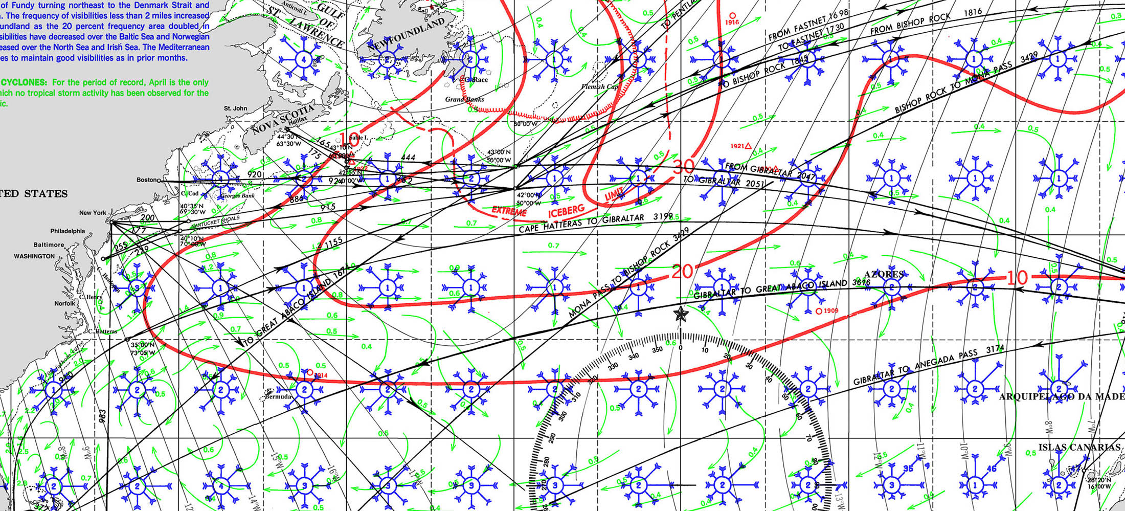
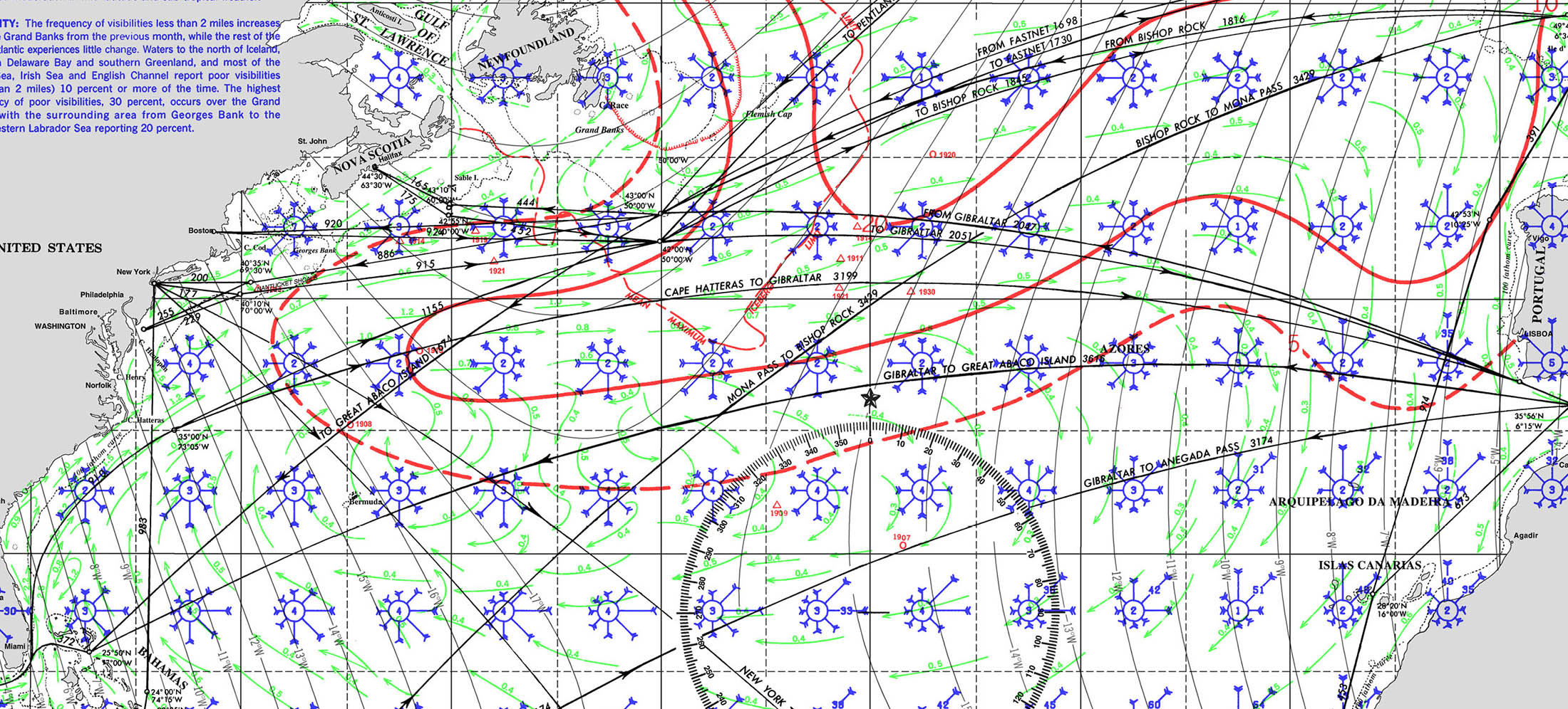
PILOT CHARTS – APRIL AND MAY
PILOT CHARTS APRIL & MAY